Central Waterfront Area Plan
NOTE: This Plan supersedes the 1990 Central Waterfront Area Plan adopted by Planning Commission Resolution 12040. The geographic area covered in this current 2008 Central Waterfront Plan is bounded by Mariposa Street on the north, San Francisco Bay on the east, Islais Creek on the south, and I-280 on the west as shown in the Land Use Concept Map.
The entire area designated as Mission Bay in the 1990 Central Waterfront Plan has been designated as two separate Redevelopment Project Areas, Mission Bay North and Mission Bay South, and is governed by the Mission Bay North and Mission Bay South Redevelopment Plans, respectively. Please refer to the Mission Bay North and Mission Bay South Redevelopment Plans, their accompanying Design for Development documents and related approval documents for sub-area-specific planning objectives, land use standards and design guidelines.
Additionally, the areas in the 1990 Central Waterfront Plan designated as Showplace Square and North Potrero are now part of a separate new Area Plan, called the Showplace Square/Potrero Hill Area Plan. The area designated as Lower Potrero is no longer identified as such and it is all part of the new Central Waterfront Plan. Please refer to those area plans for planning objectives, land use standards and other policies which govern those parcels.
INTRODUCTION
Envision...that the Central Waterfront has grown to accommodate both new housing and neighborhood commercial services while maintaining its role as an area of important economic activity; it has evolved but its character remains familiar. It is a neighborhood of well designed, mixed-use buildings that take advantage of transit and a place where new, cutting-edge businesses have appeared next door to more traditional light industrial uses. It is a place better connected to the rest of the city, with an improved public realm, welcoming streets, and well preserved historic structures, providing glimpses into the area’s past. It is a place that has grown and carefully maintained an unusual mix of uses; it is a neighborhood that has achieved a balance in the process of becoming a better place.
This is the vision that emerged from several years of community planning in the Central Waterfront as part of the city’s Better Neighborhoods program, culminating in the release of The Central Waterfront Neighborhood Plan, Draft for Public Review, in 2002. Since that point, planning for the Central Waterfront area has moved forward together with the larger Eastern Neighborhoods process, because many key issues, particularly around land use and housing, are similar for these areas.
This Central Waterfront Area Plan incorporates the ideas and vision contained in the 2002 Draft Neighborhood Plan, into the structure and general policy framework of the Eastern Neighborhoods Plans. The earlier document remains available as a rich resource of history, background material and detailed explanations of policy proposals.
The Central Waterfront today is a man-made landscape whose natural appearance has been completely transformed. The creeks, marshes, waters, and hills that dominated the area in 1850 have vanished in favor of flat lands and fill. This early transformation was accompanied by the development of industrial, maritime, and residential uses. The waterfront north of Sixteenth Street was once home to Mission Bay and Mission Creek. Once the home to industry and railroads, it is now home to the new Mission Bay development.
The waters of Mission Bay covered approximately 260 acres and, though shallow, were navigable by draft vessels. Mission Creek drained the eastern slopes of Twin Peaks and adjacent areas. Salt marshes fringed Mission Bay and Mission Creek, occupying an additional 330 acres and extending inland westward of Potrero Hill to what is now 20th and Harrison Streets.
Beginning in the 1850s, the marshes were filled by individual owners and as part of the construction of toll roads that bridged Mission Bay. Southern Pacific Railroad acquired the bulk of the Mission Bay property in 1868 and 1869 from the state and from private landowners, and gradually filled the bay during the later 19th and the early 20th centuries.
Originally, the Central Waterfront was a rocky peninsula extending from Potrero Hill approximately between 20th and 22nd Streets. The peninsula rose to an altitude of 100 feet or more above the Bay. Leveling and filling has occurred to such an extent over the years that almost no vestige of its former shape remains, save for the small portion of Irish Hill on Michigan Street that remains today.
The section of the Central Waterfront from 25th Street south to Islais Creek was developed most recently. Islais Creek originally drained the area from Twin Peaks and Glen Park to Alemany Gap. It still flows into San Francisco Bay, although its course today runs through a concrete aqueduct terminating beneath Interstate 280.
Islais Creek and the marshes surrounding it were a barrier to the southern development of San Francisco. Organized efforts for reclamation were unsuccessful until 1925, when the state passed legislation that enabled the creation of the Islais Creek Reclamation District. The district successfully filled the marshes and tidelands, and dredged Islais Creek to include a turning basin at its western end to allow for ship maneuvering. Industrial development to the north of Islais Creek was generally delayed until after World War II. During the war the area was the site of temporary housing. This housing was demolished after the war and much of the area was subsequently developed as an industrial park with single-story concrete buildings; food and oil processing plants were developed south of Army Street (now Cesar Chavez Street). The most recent filling of Islais Creek occurred during the construction of Pier 80, formerly the Army Street Ship Terminal. Financed by a state bond approved in 1958, the terminal went into operation in 1967.
Now, however, development involving the Bay is closely regulated. In response to concerns that the health of the Bay itself was being threatened, the San Francisco Bay Conservation and Development Commission (BCDC) was established by the 1965 McAteer-Petris Act. BCDC has curtailed Bay fill by regulating activities within its jurisdiction, which includes a part of the shoreline.
While there has almost always been a small residential population here, from the middle of the 19th century the Central Waterfront has been primarily a job center, not a residential neighborhood. However, even in its role as a place of work, the neighborhood has changed in response to shifts in economic conditions. From explosives manufacturing and shipbuilding to auto-oriented warehouse and distribution activities and the current eclectic mix of businesses, the Central Waterfront has reinvented itself in response to economic trends and the changing fortunes of several key industries. Throughout its history, perhaps the neighborhood’s most salient features have been its evolving industrial character and its flexibility and resilience.
Far from the center of the still-small city of San Francisco, and with access rendered difficult by the hills to the west and Mission Bay to the north, the area was remote and undeveloped. In fact, the first development sought to take advantage of Potrero Point’s remote location. Increasing population and a city ordinance promulgated in the 1850s to prevent the most dangerous industries from locating near settled areas forced certain industrial activities out of South of Market. Isolated Potrero Point, with its deep-water anchorage, was the ideal location, and by the late 1850s several gunpowder manufacturers had built factories and wharves there. Several other industries followed the gunpowder manufacturers, notably the San Francisco Cordage Manufactory (Tubbs Cordage Works), which sold ropes for shipping and mining in the Western United States, Mexico, Peru, China, and Japan. Shipbuilders, attracted by the availability of large parcels of land and a deep-water port, also began to set up operations in the area. Tubbs Cordage Works was established in 1856 on a leveled site now occupied by Muni’s Woods Yard. Included in the project was a 1500-foot ropewalk that extended into the Bay and probably served a secondary purpose as a loading wharf.
Throughout the 1860s, 1870s, and 1880s the area continued to grow into an important industrial district. William Alvord received a grant of submerged property that he filled in order to construct Pacific Rolling Mills in 1867. Pier 70 is now on this site. As fill increased, other industries located in the Potrero Point area. The San Francisco Gas Light Company began operations in 1872 and parts of it exist today in the present power plant. Other factories set up in this area included the California Poppy Soap Company, California Sugar Refinery later Sea Island Sugar House, and the American Barrel Company. The most important event in the industrial history of the area was the establishment of the Union Iron Works (UIW) shipyard at the site of what is now Pier 70 in 1883. UIW soon grew into one of San Francisco’s largest industrial establishments and became a key part of the city’s economy. Most of Potrero Point was leveled in conjunction with the construction of the iron works. Though originally known for machinery production, Union Iron Works was also active in the shipbuilding field. Its acquisition in 1905 by Bethlehem Steel led to an expansion of the company’s shipbuilding efforts. Ship production peaked during World War I and World War II and was augmented with repair and maintenance work during other times.
For decades it remained the largest employer in the area and had an enormous and lasting impact on the area. Bethlehem Steel and the other Central Waterfront industries were closely linked to the global economy: they exported mining equipment throughout the Pacific Basin and their ships traveled the world.
Despite the area’s predominantly industrial character, some housing was built. Beginning as early as the late 1860s, Irish Hill became home to a concentration of worker housing, which was eventually demolished during World War I to make room for expansion of the shipyard. In the late 1870s another residential area began to arise in Dogpatch. Whereas most inhabitants of Irish Hill were unskilled and semi-skilled Irish male laborers, Dogpatch was originally home to mainly native-born skilled craftsmen, some of whom applied their skills to building their homes. With few exceptions, most residences in the Central Waterfront were demolished over the decades. The remaining homes can be found along Tennessee Street between Eighteenth and Twenty-second Streets.
From the beginning, then, the Central Waterfront was marked by its industrial character. Despite the construction of some housing in Dogpatch, the area was always more important as an employment center than as a residential neighborhood. Even at its peak, it was never home to more than 1,200 people, whereas the local industries employed at least ten times that number during World War I.
In its role as an employment center, the Central Waterfront has demonstrated significant flexibility and resilience, “reinventing” itself several times over the course of its life. The heavy industry—primarily shipbuilding—that dominated until the end of World War II eventually gave way to a mixture of other manufacturing establishments, such as the American Can Company, and wholesale, warehousing, and distribution operations. These latter businesses grew in response to shipping activity and freeway connections to downtown and the rest of the region. This mixture of activities led to a more fine-grained pattern of buildings and users. With the loss of wartime shipbuilding activity and the other factors that caused manufacturing to move out of the city, the Central Waterfront became more specialized in distribution, primarily small-scale local distribution.
Later, in the 1980s and 1990s, the neighborhood began to attract an eclectic mix of small manufacturing firms, graphic designers, film production studios, and other activities that had either been priced out of other parts of the city or simply found the neighborhood and its buildings well suited to their purposes. Many former manufacturing buildings—notably the American Can Company buildings—became home to a wide range of small firms and played an important role as incubator space for new businesses.
In more recent years, production activities have made a comeback in the area. This appears to be due not only to the neighborhood’s continued suitability for those activities but also to the displacement of certain production activities from South of Market and the changing nature of production. For example, some printing firms have moved to the Central Waterfront in search of lower rents while the printing industry as a whole has grown in San Francisco, which is likely related to the new style of production in printing. So, in many ways, the evolution of the Central Waterfront reflects changes in production and distribution, especially as they were affected by economic cycles and advancements in technology, that the city in general has experienced.
Transportation connections to rest of the city—and the world—have always been a major factor shaping the area’s development. As mentioned above, the deep-water anchorage was one of the traits that originally made Potrero Point suitable for industry. But until 1867 the area remained cut off from the rest of the city. In that year, the Long Bridge was built across Mission Bay, extending Third Street down to the Central Waterfront and ending the area’s isolation. Horse-drawn streetcars began to roll down Third Street, followed eventually by electric streetcars. Transportation connections allowed workers to travel from elsewhere, fueling the development of industries that, unlike gunpowder manufacturing, were not drawn to the area’s isolation. Transportation also permitted a substantial segregation between industry and housing that was very different from the mixture of uses that characterized South of Market.
The Port was, of course, the largest component of the area’s transportation infrastructure for many years, and a significant amount of manufacturing and distribution activities concentrated in the Central Waterfront in order to have access to the Port. Rail spurs connected the area to the nationwide railroad network, and in 1907 the Bayshore Cutoff was completed and the Central Waterfront became the main access to the city for all trains. The post-World War II years witnessed the eventual decline of both freight and passenger rail in San Francisco. But by 1973, the extension of the I-280 freeway through the neighborhood established its appeal to trucking activities, airport shuttles, and other auto-oriented transportation and distribution companies. Transportation continues to play an important role in the area. The coming introduction of Third Street Light Rail and CalTrain improvements will enhance the neighborhood’s accessibility and thereby its attractiveness to both housing and business development. The continued presence and expansion of Muni yards represent a different, but ongoing, presence of transportation functions.
Today an unusual, sometimes fine-grained, mix of uses is one of the defining characteristics of the Central Waterfront. The wide variety of uses and the mix of building types have helped the Central Waterfront continue to be a diverse and flexible place. There are few, if any, other areas of the city that contain the same variety of activities, and this eclectic mix is cited by the residents as one of the features of the neighborhood that they value. The northern part of the Central Waterfront, west of Illinois Street, contains the most widely ranging combination of activities in the area; it is where parcels are small and the building types are the most varied. The southern part of the Central Waterfront is characterized by a more regular pattern of large parcels and primarily large, single-story buildings.
While the area has long contained residences, and even though the construction of a number of live/work buildings has altered the character of parts of the neighborhood to some degree, the Central Waterfront is nevertheless still overwhelmingly defined by the production, distribution, and repair (PDR) businesses found in the area’s many one- and two-story, mostly large floor-plate structures. San Francisco Drydock and Pier 80, the Port’s container terminal, comprise the Port’s maritime uses in this part of the waterfront; the Port has identified a portion of Pier 70 as a significant opportunity site for future development.
The most readily identifiable residential area in the Central Waterfront is found on Tennessee and Minnesota Streets, the center of the Dogpatch neighborhood. Many of the houses in this area were built around the turn of the century, if no earlier, and are typically one- to two-story structures. In fact, the neighborhood has a significant concentration of historic buildings, including the I.M. Scott School and the old fire and police stations in Dogpatch itself, as well as a number of structures on Port property associated with the old Union Iron Works and Bethlehem Steel. In coordination with residents, the city is in the process of designating a Dogpatch historic district.
Unlike most typical residential neighborhoods, a number of PDR businesses are intermingled with the residences. This mixing has continued with the more recent housing development, which has come in the form of live/work units scattered throughout the area.
As of the year 2000, the Central Waterfront’s population numbered about 850, and it contained about 457 housing units (including live/work), though these figures are actually a little higher as several live/work projects have been completed in the interim. The neighborhood’s sparse residential population has limited the number of neighborhood-serving businesses it can support. A small collection of such shops and services are found at 22nd Street, which serves as the commercial “heart” of Dogpatch. Esprit Park, recently transferred to city ownership, is the neighborhood’s primary open space.
In addition to the Eastern Neighborhoods-wide goals outlined above, the following community-driven goals were developed specifically for Central Waterfront, over the course of many public workshops:
Encourage development that builds on the Central Waterfront’s established character as a mixed-use, working neighborhood.
Foster the Central Waterfront’s role in the city’s economy by supporting existing and future production, distribution, repair, and maritime activities.
Increase housing in the Central Waterfront without impinging on or creating conflicts with identified existing or planned areas of production, and repair activities.
Establish a land use pattern that supports and encourages transit use, walking, and biking.
Better integrate the Central Waterfront with the surrounding neighborhoods and improve its connections to Port land and the water’s edge.
Improve the public realm so that it better supports new development and the residential and working population of the neighborhood.
1. Land Use
OBJECTIVE 1.1
ENCOURAGE THE TRANSITION OF PORTIONS OF THE CENTRAL WATERFRONT TO A MORE MIXED-USE CHARACTER, WHILE PROTECTING THE NEIGHBORHOOD’S CORE OF PDR USES AS WELL AS THE HISTORIC DOGPATCH NEIGHBORHOOD
Portions of the Central Waterfront have been transitioning from PDR to a more mixed-use character. This has been particularly the case in the northern portion of the neighborhood, with new residential development and a small amount of new retail occurring along Third Street. In addition, life science and medical related uses are expected to desire locations close to Mission Bay in the northern portion of this neighborhood. This mix of uses in the northern portion of the neighborhood should be maintained and promoted, while the core PDR areas south of 23rd Street and east of Third Street should be protected.
Because of its proximity to Mission Bay and the UCSF research and hospital facilities there, Central Waterfront is a logical place to encourage development of life-science related research institutions.
The existing Dogpatch residential neighborhood and its small adjacent neighborhood commercial district constitute a unique enclave within the larger Central Waterfront area. The historic homes in this area, along Tennessee and Minnesota Streets, were built around the turn of the twentieth century and earlier. Land use controls in this area should ensure its future as a small-scale residential enclave.
Controls should also maintain and protect the unique character of the Central Waterfront’s existing neighborhood commercial area. Twenty-Second Street is already the focus of retail activity for the neighborhood and connects the CalTrain Station to Third Street. Continuing to encourage retail on the ground floor between Third and Minnesota Streets builds on the existing character of the street, concentrates activity, and helps to create a “neighborhood heart.” To ensure compatibility with the existing scale of these areas, large lot development and lot mergers should be restricted and business sizes carefully controlled.
The Port conducted a community planning process to develop a comprehensive strategy for Pier 70, including the shipyard area, and created the Pier 70 Union Iron Works Historic District, which is listed on the National Register of Historic Places. The Pier 70 area is generally defined as the area east of Illinois Street between Mariposa Street and 22nd Street.
The Pier 70 community planning collaborations built support for developer partnerships and the creation of the Pier 70 Special Use District. The Port and City are working in coordination with the developers to implement improvements consistent with, and incorporated by reference in, the Port’s Waterfront Plan. The Pier 70 Special Use District will: 1) rehabilitate and adaptably reuse Pier 70 Historic Resources; 2) support maritime industry; 3) provide new Blue Greenway open spaces including shoreline access; 4) conduct as-needed environmental remediation; 5) provide for new infill development that is adaptively designed to address sea level rise; 6) develop new infrastructure required to support the development; and 7) provide a funding stream to implement the variety of goals defined for the site. Adjacent to Pier 70, the site of the former Potrero Power Station is now proposed for mixed-use development, as further described in Policy 1.1.8.
This Plan’s approach to land use controls in the Central Waterfront neighborhood consists of the following key elements:
In the northern part of the Central Waterfront (generally north of 23rd Street and west of Illinois Street) establish new controls that allow mixed-income residential development, while limiting new office and retail development.
Provide a buffer around the Dogpatch neighborhood, where larger office and life clinical facilities would not be permitted.
In the core PDR area, generally south of 23rd Street, establish new controls that protect PDR businesses by prohibiting new residential development and limiting new office and retail development.
In areas controlled by the Port as well as the Potrero Power Station site, guide improvements according to the Pier 70 Special Use District and Potrero Power Station Special Use District Development Agreements’ planning policies, zoning controls, and design standards, and maintain existing industrial zoning of Port property outside of the Pier 70 area.
Address Seal Level Rise as an integral goal when planning and designing new buildings and developments along the waterfront.
The policies to address the needs highlighted include the following:
POLICY 1.1.1
In the core PDR area generally south of 23rd Street, protect and promote PDR activities, as well as the arts, by prohibiting construction of new housing and limiting the amount of new office and retail uses.
POLICY 1.1.2
Maintain the revised land use controls in formerly industrial areas outside the core Central Waterfront industrial area, which creates new mixed use areas, and allow mixed-income housing as a principal use, as well as limited amounts of retail, office, and research and development, while protecting against the wholesale displacement of PDR uses.
POLICY 1.1.3
Permit and encourage life science and medical related use at the most appropriate locations.
POLICY 1.1.4
Maintain the integrity of the historic Dogpatch neighborhood.
POLICY 1.1.5
Create a buffer around the Dogpatch neighborhood to protect against encroachment of larger office and life science research uses.
POLICY 1.1.6
Permit and encourage small and moderate size retail establishments in neighborhood commercial areas of Central Waterfront, while allowing larger retail in the new Urban Mixed Use districts only when part of a mixed-use development.
POLICY 1.1.7
Ensure that development at Pier 70 supports Port and City land use and planning policies and design standards set forth in the Pier 70 Special Use District, and complements the maritime and industrial nature of the area.
POLICY 1.1.8
Ensure the development of the Potrero Power Station Mixed-Use Development Project, a multi-phase 29 acre master development that was approved in 2019; the Potrero Power Station Mixed-Use Development Project includes a wide mix of residential, non-residential, and community facility uses along with a wide variety of recreational and open space facilities that, among other goals, provide a continuous sequence of park and recreational opportunities along and to the Bay waterfront. Integral to the Power Station Development are strategies that assure the development is sustainable and resilient, particularly to Sea Level Rise.
POLICY 1.1.9
Permit and encourage greater retail uses on the ground floor on parcels that front 3rd Street to take advantage of transit service and encourage more mixed uses, while protecting against the wholesale displacement of PDR uses.
POLICY 1.1.10
While continuing to protect traditional PDR functions that need large, inexpensive spaces to operate, also recognize that the nature of PDR businesses is evolving gradually so that their production and distribution activities are becoming more integrated physically with their research, design and administrative functions.
OBJECTIVE 1.2
IN AREAS OF THE CENTRAL WATERFRONT WHERE HOUSING AND MIXED-USE IS ENCOURAGED, MAXIMIZE DEVELOPMENT POTENTIAL IN KEEPING WITH NEIGHBORHOOD CHARACTER
It is important that new housing is developed in appropriate areas, that it is compatible with its surroundings, and that it satisfies community housing needs. Permitting some housing in formerly industrial areas along with improved transit service allows new development to capitalize on existing infrastructure. By increasing development potential on some parcels, reducing parking requirements, and replacing existing unit density controls with “bedroom mix” controls that require a portion of new units to be larger and more family-friendly, more housing of the appropriate type can be encouraged.
Strong building design controls, discussed further in the Built Form chapter of this Plan, should ensure that these new buildings are designed to be compatible with their surroundings. Building facades should be broken up, development above a certain height should be set back on small residential alleys to allow light and air, and active ground floors should be required.
The policies to address the objective outlined above are as follows:
POLICY 1.2.1
Ensure that infill housing development is compatible with its surroundings.
POLICY 1.2.2
For new construction, and as part of major expansion of existing buildings in neighborhood commercial districts, require housing development over commercial. In other mixed-use districts encourage housing over commercial or PDR where appropriate.
POLICY 1.2.3
In general, where residential development is permitted, control residential density through building height and bulk guidelines and bedroom mix requirements.
POLICY 1.2.4
Identify portions of Central Waterfront where it would be appropriate to increase maximum heights for residential development.
OBJECTIVE 1.3
INSTITUTE FLEXIBLE “LEGAL NONCONFORMING USE” PROVISIONS TO ENSURE A CONTINUED MIX OF USES IN THE CENTRAL WATERFRONT
Although heavily industrial, Central Waterfront contains a mix of offices, retail, housing and other uses, in addition to PDR businesses. The intent of the Plan is to create successful mixed areas where PDR uses can compete well with other uses in the future. To ensure that this mix remains in place, existing office and retail establishments in the Mixed Use and PDR districts of Central Waterfront should be allowed to stay, as long as they were legally established in the first place. Property owners whose office and retail tenants leave should be allowed to replace them within a reasonable period of time with similar tenants.
Existing legal nonconforming use rules already provide substantial protections to certain types of establishments that pre-date the proposed rezoning. For example, in areas where limitations will be imposed under new zoning on retail and office uses, existing office and retail uses that do not comply with this limitation would be able to remain, provided they were legally established in the first place.
However, existing rules do not contemplate districts where housing units are prohibited outright. Because new zoning will create such districts, the nonconforming use provisions in the Planning Code should be modified in order to allow for the continuance of existing housing in areas where housing will no longer be permitted under the new zoning.
The policies to address the objective outlined above are as follows:
POLICY 1.3.1
Continue existing legal nonconforming rules, which permit pre-existing establishments to remain legally even if they no longer conform to new zoning provisions, as long as the use was legally established in the first place.
POLICY 1.3.2
Provide flexibility for legal housing units to continue in districts where housing is no longer permitted.
POLICY 1.3.3
Recognize desirable existing uses in the former industrial areas which would no longer be permitted by the new zoning, and afford them appropriate opportunities to establish a continuing legal presence.
OBJECTIVE 1.4
SUPPORT A ROLE FOR “KNOWLEDGE SECTOR” BUSINESSES IN APPROPRIATE PORTIONS OF THE CENTRAL WATERFRONT
The “Knowledge Sector” consists of businesses that create economic value through the knowledge they generate and provide for their customers. These include businesses involved in financial services, professional services, information technology, publishing, digital media, multimedia, life sciences (including biotechnology), and environmental products and technologies. The Knowledge Sector contributes to the city’s economy through the high wages these industries generally pay, creating multiplier effects for local-serving businesses in San Francisco, and generating payroll taxes for the city. Although these industries generally require greater levels of training and education than PDR workers typically possess, they may in the future be able to provide a greater number of quality jobs for some San Franciscans without a four-year college degree, provided appropriate workforce development programs are put in place.
From a land use perspective, the Knowledge Sector utilizes a variety of types of space. Depending on the particular needs of a company, this may include buildings for offices, research and development (R&D), and manufacturing. Mixed-use and industrial land in the Central Waterfront benefit from lower rents and less-intensive development than other parts of the city. These characteristics may allow for the location of manufacturing and R&D components of the Knowledge Sector, as well as provide some Class B office space suitable for Knowledge Sector companies who cannot afford or would prefer not to be located downtown. Additionally, the proximity of the Central Waterfront to the life science research and medical uses of Mission Bay support a concentration of life science uses in parts of the Central Waterfront. These uses could be supported in the following manner:
The PDR component of the Knowledge Sector could locate throughout the Mixed Use and PDR districts of the Central Waterfront.
The office component of the Knowledge Sector should be directed towards space above the ground floor in buildings in the Central Waterfront’s Mixed Use and PDR-1 districts. The amount of office in these buildings should be restricted to support PDR uses above the ground floor.
-
R&D uses range from being office-only to a mixture of office and production and testing. To the degree that uses are office-only, they will face the same controls as office uses. The more R&D uses could be located throughout the Mixed Use and PDR districts, though the office component would be subject to office controls.
The policies to address the objective outlined above are as follows:
POLICY 1.4.1
Continue to permit manufacturing uses that support the Knowledge Sector in the Mixed Use and PDR districts of the Central Waterfront.
POLICY 1.4.2
Allow medical office and life science uses in portions of the Central Waterfront where it is appropriate.
POLICY 1.4.3
Allow other Knowledge Sector office uses in portions of the Central Waterfront where it is appropriate.
POLICY 1.4.4
Identify portions of the Central Waterfront where it would be appropriate to allow other research and development uses that support the Knowledge Sector.
OBJECTIVE 1.5
MINIMIZE THE IMPACT OF NOISE ON AFFECTED AREAS AND ENSURE GENERAL PLAN NOISE REQUIREMENTS ARE MET
Noise, or unwanted sound, is an inherent component of urban living. While environmental noise can pose a threat to mental and physical health, potential health impacts can be avoided or reduced through sound land use planning. The careful analysis and siting of new land uses can help to ensure land use compatibility, particularly in zones which allow a diverse range of land uses. Traffic is the most important source of environmental noise in San Francisco. Commercial land uses also generate noise from mechanical ventilation and cooling systems, and though freight movement. Sound control technologies are available to both insulate sensitive uses and contain unwanted sound. The use of good urban design can help to ensure that noise does not impede access and enjoyment of public space.
The policies to address the objective outlined above are as follows:
POLICY 1.5.1
Reduce potential land use conflicts by providing accurate background noise-level data for planning.
POLICY 1.5.2
Reduce potential land use conflicts by carefully considering the location and design of both noise generating uses and sensitive uses in the Central Waterfront.
OBJECTIVE 1.6
IMPROVE INDOOR AIR QUALITY FOR SENSITIVE LAND USES IN THE CENTRAL WATERFRONT
Exposure to air pollutants can pose serious health problems, particularly for children, seniors and those with heart and lung diseases. Sound land use planning aims to reduce air pollution emissions by co-locating complementary land uses, which helps to decrease automobile traffic and encourage walkability and by avoiding land use-air quality conflicts that can result in exposure to air pollutants. While there are numerous social, environmental and economic benefits associated with integrating land use and transportation, there is also a potential risk of exposing residents to poor indoor air quality when infill residential developments are located in close proximity to air pollution sources, including traffic sources such as freeways or major streets. Epidemiologic studies have consistently demonstrated that children and adults living in proximity to busy roadways have poorer health outcomes, including higher rates of asthma disease and morbidity and impaired lung development. Given increasing demands for housing, particularly affordable housing, and the limited amount of available and suitable land for housing in San Francisco, it is important that the review process for proposed development projects incorporate analysis and mitigation of air quality conflicts, particularly with respect to sensitive land uses such as housing, schools, daycare and medical facilities.
The policy to address the objective outlined above is as follows:
POLICY 1.6.1
Minimize exposure to air pollutants from existing traffic sources for new residential developments, schools, daycare and medical facilities.
OBJECTIVE 1.7
RETAIN THE CENTRAL WATERFRONT’S ROLE AS AN IMPORTANT LOCATION FOR PRODUCTION, DISTRIBUTION, AND REPAIR (PDR) ACTIVITIES
It is important for the health and diversity of the city’s economy and population that space in San Francisco be preserved for Production, Distribution, and Repair (PDR) activities. PDR jobs account for nearly all jobs in the Central Waterfront. These jobs tend to pay above average wages, provide jobs for residents of all education levels, particularly immigrants, and offer good opportunities for advancement.
PDR is also a valuable export industry. PDR businesses that design or manufacture products in San Francisco often do so because of advantages unique to being located in the city. These export industries present an opportunity to grow particular PDR sectors, strengthening and diversifying our local economy. PDR also supports the competitiveness of knowledge industries by providing critical business services that need to be close, timely and often times are highly specialized.
The Central Waterfront remains part of the city’s core industrial area and contains a significant amount of the city’s remaining industrial land. Since the 1850s, the Central Waterfront has played an important and dynamic role within the city’s economy and land use system, providing critical “flex-space” for new and changing industries, and is one of the last areas of the city still suited for this purpose. Along the waterfront, almost half of the land area is controlled by state regulations that only allow maritime related, essentially industrial, uses as permanent activities that service the Port. Many PDR businesses and jobs are located here that help to diversify and strengthen San Francisco’s economy and space should remain available for their use.
The Central Waterfront, particularly the portions south of 23rd Street and east of 3rd Street, has several characteristics particularly favorable for PDR businesses. This area contains important building stock that has the features desirable for many PDR businesses, including large floor plates, clerestory structures and loading docks, for example. This space is comparatively far from residential areas and rents for prices that are affordable to PDR businesses.
Many of these businesses form clusters, including arts activities, that are unique to San Francisco and provide services and employment for local residents. Establishing space for PDR activities that is protected from encroachment by other uses responds to existing policy set forth in the city’s General Plan, particularly the Commerce and Industry Element (C&I), that includes the following pertinent policies:
Seek to retain existing commercial and industrial activity and to attract new such activity to the city (Objective 2, Policy 1)
Promote the attraction, retention, and expansion of commercial and industrial firms which provide employment improvement opportunities for unskilled and semi-skilled workers (Objective 3, Policy 1)
Avoid public actions that displace existing viable industrial firms (Objective 4, Policy 3)
When Displacement does occur, attempt to relocate desired firms within the city (Objective 4, Policy 4)
Avoid encroachment of incompatible land uses on viable industrial activity (Objective 4, Policy 5)
Maintain an adequate supply of space appropriate to the needs of incubator industries (Objective 4, Policy 11)
Generally, establishing areas for PDR businesses achieves the following:
Stabilize activities that are susceptible to displacement including arts activities.
Stabilize areas that contain concentrations of blue collar, unskilled and semi-skilled jobs.
Helps to ensure the availability of jobs across all economic sectors, providing a wide range of employment opportunities for San Francisco’s diverse population.
Ensures that there is space for activities important to meeting the city’s everyday needs.
Ensures that there is space for businesses that support the city’s wider economy and health.
Ensures that there is space for new business sectors to emerge, which helps San Francisco to maintain its role as a regional center.
Fosters a diverse economy, which helps to ensure the city’s long-term economic vibrancy.
POLICY 1.7.1
In areas designated for PDR, protect the stock of existing buildings used by, or appropriate for, PDR businesses by restricting conversions of industrial buildings to other building types.
POLICY 1.7.2
Ensure that any future rezoning of areas within PDR districts is proposed within the context of periodic evaluation of the city’s needs for PDR space.
PDR districts proposed in this Plan were established to acknowledge and protect existing clusters of PDR activity and to provide an appropriate land supply to accommodate the city’s need for PDR businesses into the foreseeable future. Land use needs change over time, but case-by-case rezoning of individual parcels or groups of parcels within larger PDR districts would disrupt the integrity of the districts. Proposed rezoning should only be considered in the context of an evaluation and monitoring report of the Eastern Neighborhoods Plans, to be conducted by the Planning Department at five-year intervals.
POLICY 1.7.3
Require development of flexible buildings with generous floor-to-ceiling heights, large floor plates, and other features that will allow the structure to support various businesses.
Flexibly designed buildings with high floor-to-ceiling heights best accommodate the PDR businesses of today and tomorrow. Such spaces, equipped with roll-up doors or other large apertures, for example, facilitate the movement of goods and supplies.
OBJECTIVE 1.8
PROTECT MARITIME AND MARITIME-RELATED ACTIVITIES IN THE CENTRAL WATERFRONT
The Central Waterfront has long been home to maritime activities, including the existing Pier 70 shipyard. As a response to the advent of containerization in the 1960s, the Port of San Francisco began to focus its cargo operations at Pier 80, and south of Islais Creek at Piers 94-96. Maintaining and supporting these activities, including ship repair, maritime support, warehousing and storage, and shipping, is important to both the Port’s mission and more generally to San Francisco’s economy. The various industrial activities occurring on and near Port land need to be able to carry out their operations without the impediments caused by the presence of sensitive land uses such as housing or neighborhood-related activities.
Shipbuilding and ship repair had been carried out at the Pier 70 dry dock since the late 1880s. In fact, Pier 70 hosted the longest continually operating, non-military dry dock on the West Coast. While the Port’s ship repair operator terminated operations in 2017, the Pier 70 shipyard will continue to serve various maritime and industrial uses. Any development adjacent to the shipyard facility should not impinge on its maritime and industrial use.
The Port’s terminal at the 69-acre Pier 80 is in active use, providing the Port and city with non-container-cargo handling facilities. The businesses at and related to Pier 80 are well integrated with the city’s economy; they employ a substantial number of people, generate income for the Port, and taxes for the city. Continued, efficient access by freight rail and truck from the peninsula, freeways, and via city streets is fundamental to the viability of the pier and the industries related to it. Therefore, transportation infrastructure in the vicinity of Pier 80 should not be changed in ways that would interfere with its continued efficient operation.
The policies to address the needs highlighted above are as follows:
POLICY 1.8.1
Ensure that development adjacent to the Pier 70 and Pier 80 facilities does not conflict with intensive 24-hour industrial operations characteristic of these sites or conflict with transportation access to these areas.
POLICY 1.8.2
To better serve businesses and industry, enhance the infrastructure and working environment within areas designated for maritime uses.
2. Housing
The Central Waterfront is a unique neighborhood – an area where historic and new housing, neighborhood landmarks, and industrial and port activities mix. It is sited along the City’s valuable water edge with a major transit line, Muni’s newly constructed Third Street Light Rail line, at its heart. Its transformation from traditional port activities has resulted in under used land, and in turn to the capacity to accommodate a significant amount of new housing.
The current residential population of the Central Waterfront is significantly smaller then the other Eastern Neighborhoods, which has limited the number of neighborhood-serving businesses in the area. Bringing housing to the Central Waterfront is critical to supporting a much-needed increase in neighborhood commercial services, to enlivening open spaces, and to creating a vibrant and cohesive residential neighborhood.
The Central Waterfront continues to be home to many production, distribution, and repair firms (PDR), the traditional users of industrial land, which are an important part of the city’s economy. Unlike most typical residential neighborhoods, a number of PDR businesses are intermingled with residential uses. This mixing has continued with more recent housing development, in the form of live/work units. Given the importance of PDR jobs to the city’s economy and the increasing demands for housing, the balance of these two uses remains an important goal, as well as a challenge.
The production of affordable housing is one of the main goals of the Central Waterfront Area plan, in order to provide housing for residents who are overburdened by their housing costs. “Affordable housing” refers simply to apartments or condominiums that are priced so as not to financially burden a household – housing costs that do not prevent individuals or families of any income level from affording other necessities of life, such as food, clothing, transportation and medical care.
What constitutes an affordable rent or mortgage is more specifically defined locally as a proportion of annual income for individuals and families. Households are categorized by income as very low, low, and moderate income households based on their relation to the median income. (“Median income” means the level at which exactly half of the City’s households earn are below, and half are above) According to the Mayor’s Office of Housing, the median income for 2007 for a household with four members in San Francisco was $80,319. Yet the substantial majority of market-rate homes for sale in San Francisco are priced out of the reach of low and moderate income households – less than 10 percent of households in the City can afford a median-priced home.
The City’s Inclusionary Affordable Housing Program is one existing method by which the City produces several Below-Market-Rate (BMR) units to families and individuals’ earning below what is required to afford market prices. Under the amended 2006 Ordinance, market-rate developments of five units or more are required to include a mandatory fifteen percent of the project’s total units as BMR’s, which are affordable to low and moderate-income buyers (for rentals, people earning below 60 percent of median; for ownership units, people earning between 80 and 120 percent of median). Alternatively, developments may select an equivalent option of off-site development or payment of in-lieu fee.
However, this program only covers those earning up to 120 percent of median income, which in 2007 was $96,400 for a household of four. Yet even families earning more than this have difficulty affording housing in San Francisco. Almost 30 percent of its households fall in the bracket of moderate and middle incomes. Housing for working households remains one of the City’s greatest needs.
The Central Waterfront Plan strives to meet six key objectives surrounding housing production and retention:
The Plan strives to construct new housing affordable to people with a wide range of incomes via the rezoning of some of the City’s industrial lands. It assists households at low and very low-incomes through inclusionary and land dedication strategies. It aims to help people making above the 120 percent of median income threshold for inclusionary housing but below the amount required to afford market-rate units, through “middle income” development options.
The Plan strives to retain and improve existing housing, in recognition of the fact that sound existing housing is one of the most valuable sources of housing the City has.
The Plan ensures that residential development meets not only the affordability needs, but the other needs- unit size, number of bedrooms, community services and neighborhood amenities – to create a high quality of life for all individuals and families in the Eastern Neighborhoods.
The Plan aims to lower the costs of housing production to translate into lower-priced units, by enabling cost-effective construction and by recognizing that “time is money”, in reducing unnecessary processes.
The Plan aims to promote health and well-being for residents, through well-designed, environmentally friendly neighborhoods and units.
The Plan aims to continue the City’s ongoing efforts to increase affordable housing and production, through increased funding available for affordable housing through City, state, federal and other sources.
OBJECTIVE 2.1
ENSURE THAT A SIGNIFICANT PERCENTAGE OF NEW HOUSING CREATED IN THE CENTRAL WATERFRONT IS AFFORDABLE TO PEOPLE WITH A WIDE RANGE OF INCOMES
The City of San Francisco has produced a significant number of market-rate units in the last five years, yet still has many units to produce at low, moderate and middle incomes if it is to meet the spectrum of need identified in the Housing Element of the General Plan. San Francisco’s Housing Element establishes the plan area, as well as the entirety of the Eastern Neighborhoods, as a target area in which to develop new housing to meet San Francisco’s identified housing targets in the category of low, moderate and middle income units. A portion of the industrial lands of the Eastern Neighborhoods – areas formerly zoned for C-M, M-1, and M-2, but not required to meet current PDR needs – offer an opportunity to zone areas to meet these identified categories of need.
In order to facilitate the housing production percentage targets identified in the Housing Element, this plan sets forth new zoning districts on formerly industrial lands that enable the production of the type of housing San Francisco needs. In these new zoning districts, affordable housing would be permitted as of right. However, not all sites will be appropriate for the development of 100 percent affordable housing projects, or are available for development.
Under the “mixed-income” housing requirements, in the formerly industrial zones, where market-rate housing was previously restricted, would be modified to allow developers to meet affordability needs. Those wishing to develop market-rate housing would be able to do so only under the following requirements:
Provide a high percentage of units affordable to very low, low, or moderate income households on-site (through superinclusionary requirements, above and beyond the City’s Inclusionary Program) in a mixed-income project.
Dedicate land for the development of 100 percent affordable housing, available to very low and low-income households.
Provide moderately affordable units on-site, as housing available to middle income households – those making below 150 percent of the median income.
Site developability in these areas will be increased by removal of density controls and in some cases through increased heights, to address the City’s most pressing housing needs.
Single Room Occupancy (SRO) units – defined by the Planning Code as units consisting of no more than one room at a maximum of 350 square feet – represent an important source of affordable housing in the Central Waterfront, representing 6 percent of the total housing units. (There are an estimated 457 SRO Hotels in San Francisco with over 20,000 residential units, with most located in the Mission, Tenderloin, Chinatown, and South of Market). SRO units have generally been considered part of the city’s stock of affordable housing, and as such, City law prohibits conversion of SROs to tourist hotels. SROs serve as an affordable housing option for elderly, disabled, and single-person households, and in recognition of this, the Plan adopts several new policies to make sure they remain a source of continued affordability. Therefore, SROs are permitted as a category of housing available to moderate, middle income and low income households. In recognition of the fact that SROs serve small households, the Plan exempts SRO developments from meeting unit-mix requirements. In recognition of the fact that SROs truly are living spaces, and to prevent the kind of sub-standard living environments that can result from reduced rear yards and open spaces, this Plan requires that SROs adhere to the same rear yard and exposure requirements as other types of residential uses. Finally, the Plan calls for sale and rental prices of SROs to be monitored regularly to ensure that SROs truly remain a source of affordable housing, and that policies promoting them should continue.
The policies to address the objective outlined above are as follows:
POLICY 2.1.1
Require developers in some formally industrial areas to contribute towards the City’s very low, low, moderate and middle income needs as identified in the Housing Element of the General Plan.
POLICY 2.1.2
Provide land and funding for the construction of new housing affordable to very low and low-income households.
POLICY 2.1.3
Provide units that are affordable to households at moderate and ”middle incomes” – working households earning above traditional below-market-rate thresholds but still well below what is needed to buy a market priced home, with restrictions to ensure affordability continues.
POLICY 2.1.4
Allow single-resident occupancy hotels (SROs) and “efficiency” units to continue to be an affordable type of dwelling option, and recognize their role as an appropriate source of housing for small households.
OBJECTIVE 2.2
RETAIN AND IMPROVE EXISTING HOUSING AFFORDABLE TO PEOPLE OF ALL INCOMES
The existing housing stock is the City’s major source of relatively affordable housing. The Eastern Neighborhoods’ older and rent-controlled housing has been a long-standing resource for the City’s lower and middle income families.. Priority should be given to the retention of existing units as a primary means to provide affordable housing. Demolition of sound existing housing should be limited, as residential demolitions and conversions can result in the loss of affordable housing. The General Plan discourages residential demolitions, except where they would result in replacement housing equal to or exceeding that which is to be demolished. The Planning Code and Commission already maintain policies that generally require conditional use authorization or discretionary review wherever demolition is proposed. In the Eastern Neighborhoods, policies should continue requirements for review of demolition of multi-unit buildings. A permit to demolish a residence cannot be issued until the replacement structure is approved. When approving such a demolition permit and the subsequent replacement structure, the Commission should review levels of affordability and tenure type (e.g. rental or for-sale) of the units being lost, and seek replacement projects whose units replaced meet a parallel need within the City. The goal of any change in existing housing stock should be to ensure that the net addition of new housing to the area offsets the loss of affordable housing by requiring the replacement of existing housing units at equivalent prices.
The rehabilitation and maintenance of the housing stock is also a cost-effective and efficient means of insuring a safe, decent housing stock. A number of cities have addressed this issue through housing rehabilitation programs that restore and stabilize units already occupied by low-income households. While the City does have programs to finance housing rehabilitation costs for low-income homeowners, it could expand this program to reach large scale multi-unit buildings. Throughout the project area, the City could work to acquire and renovate existing low-cost housing, to ensure its long-term affordability.
The policies as well as implementing actions to address the objective outlined above are as follows:
POLICY 2.2.1
Adopt Citywide demolition policies that discourage demolition of sound housing, and encourage replacement of affordable units.
POLICY 2.2.2
Preserve viability of existing rental units.
POLICY 2.2.3
Consider acquisition of existing housing for rehabilitation and dedication as permanently affordable housing.
POLICY 2.2.4
Ensure that at-risk tenants, including low-income families, seniors, and people with disabilities, are not evicted without adequate protection.
OBJECTIVE 2.3
REQUIRE THAT A SIGNIFICANT NUMBER OF UNITS IN NEW DEVELOPMENTS HAVE TWO OR MORE BEDROOMS EXCEPT SENIOR HOUSING AND SRO DEVELOPMENTS UNLESS ALL BELOW MARKET RATE UNITS ARE TWO OR MORE BEDROOM UNITS
The need for housing in Central Waterfront covers the full range of tenure type (ownership versus rental) and unit mix (small versus large units). While there is a market for housing at a range of unit types, recent housing construction has focused on the production of smaller, ownership units. Yet 90 percent of residents in Central Waterfront are renters. The Housing Element of the City’s General Plan recognizes that rental housing is more immediately accessible, and often more affordable than for-sale housing, and existing city policies regulate the demolition and conversion of rental housing to other forms of occupancy. New development in the Central Waterfront area should provide rental opportunities for new residents as well.
To try to achieve more family friendly housing, the Plan makes several recommendations. New development will be required to include a significant percentage of units with two or more bedrooms (SROs and senior housing will be exempted from this requirement). Family friendly design should incorporate design elements such as housing with private entrances, on-site open space at grade and accessible from the unit, inclusion of other play spaces such as wide, safe sidewalks, on-site amenities such as children’s recreation rooms or day-care. The Planning Department can also encourage family units by drafting family-friendly guidelines to guide its construction, and by promoting projects which include multi-bedroom housing located in close proximity to schools, day-care centers, parks and neighborhood retail. Projects which met such guidelines could be provided faster processing time, including streamlined processing.
One of the key priorities of the Mayor’s Office of Housing is expanding the stock of family rental housing, with particular emphasis on very low and extremely low-income families. The Plan encourages the Mayor’s Office to maintain this priority in funding 100 percent affordable housing developments that provide safe, secure housing with multiple bedrooms and family-oriented amenities such as play areas and low-cost child care.
In addition to the type of housing constructed, it is important to consider the services and amenities available to residents – transit, parks, child care, library services, and other community facilities. Many parts of the Eastern Neighborhoods are already underserved in many of these categories; and the lower income, family-oriented households of these neighborhoods, more than any other demographic, have a need for these services. The Plan aims to improve the neighborhoods, and to meet the needs that new residential units in the Eastern Neighborhoods will create, including increased demands on the area’s street network, limited open spaces, community facilities and services1. New development will be required to contribute towards improvements that mitigate their impacts. The resulting community infrastructure, constructed through these funds and through other public funding, will benefit all residents in the area.
1. See the "San Francisco Eastern Neighborhoods Needs Assessment," developed by Seifel Consulting Inc, November 2007, for an assessment of the current and future need for community services and amenities in the Eastern Neighborhoods.
The public benefits funds generated will support improvements to community infrastructure, including parks, transit, child care, libraries, and other community facilities needed by all new residents, but particularly needed by lower-income residents and families. Often, affordable housing exists in areas with poor neighborhood quality of life, poor access to transit and unreliable neighborhood services; yet the lower income households, more than any other demographic, have a need for these services. The public benefit policies intended to mitigate new development’s impacts will, in cooperation with other public funding, ensure that not only new housing, but also existing affordable housing, receives the community infrastructure a good neighborhood needs.
The policies as well as implementing actions to address the objective outlined above are as follows:
POLICY 2.3.1
Target the provision of affordable units for families.
POLICY 2.3.2
Prioritize the development of affordable family housing, both rental and ownership, particularly along transit corridors and adjacent to community amenities.
POLICY 2.3.3
Require that a significant number of units in new developments have two or more bedrooms, except Senior Housing and SRO developments.
POLICY 2.3.4
Encourage the creation of family supportive services, such as child care facilities, parks and recreation, or other facilities, in affordable housing or mixed-use developments.
POLICY 2.3.5
Explore a range of revenue- generating tools including impact fees, public funds and grants, assessment districts, and other private funding sources, to fund community and neighborhood improvements.
POLICY 2.3.6
Establish an impact fee to be allocated towards an Eastern Neighborhoods Public Benefit Fund to mitigate the impacts of new development on transit, pedestrian, bicycle, and street improvements, park and recreational facilities, and community facilities such as libraries, child care and other neighborhood services in the area.
OBJECTIVE 2.4
LOWER THE COST OF THE PRODUCTION OF HOUSING
There is a demonstrated need to reduce the overall cost of housing development and therefore reduce rental rates and purchase prices. Revising some requirements associated with housing development and expediting processing can help lower costs. The city’s current minimum parking requirement, for example, is a significant barrier to the production of housing, especially affordable housing. In much of the housing built under current parking requirements, the cost of parking is included in the cost of owning or renting a home, requiring households to pay for parking whether or not they need it. As part of an overall effort to increase housing affordability in the plan area, costs for parking should be separated from the cost of housing and, if provided, offered optionally.
There are a number of design and construction techniques that can make housing “affordable by design” – efficiently designed, less costly to construct, and therefore less costly to rent or purchase. For example, forgoing structured parking can significantly reduce construction costs. Thus, as part of this Plan, parking requirements will be revised to allow, but not require parking. This provision will allow developers to build a reasonable amount of parking if desired, and if feasible while meeting the Plan’s built form guidelines. Small infill projects, senior housing projects or other projects that may desire to provide fewer parking spaces would have the flexibility to do so. Also, conventionally framed low-rise construction is less costly than high rise construction requiring steel and concrete. City actions including modifying zoning and building code requirements to enable less costly construction, as well as encouraging smaller room sizes and units that include fewer amenities or have low-cost finishes while not yielding on design and quality requirements, can facilitate these techniques.
Finally the approval process for housing can be simplified, to reduce costs associate with long, protracted approval periods. Discretionary processes such as Conditional Use authorizations, and mandatory (i.e. non community initiated) Discretionary Review, should be limited as much as possible while still ensuring adequate community review. Provisions within CEQA should be used to that enable exemptions or reduced review, including reduced traffic analysis requirement for urban infill residential projects.
The policies as well as implementing actions to address the objective outlined above are as follows:
POLICY 2.4.1
Require developers to separate the cost of parking from the cost of housing in both for sale and rental developments.
POLICY 2.4.2
Revise residential parking requirements so that structured or off-street parking is permitted up to specified maximum amounts in certain districts, but is not required.
POLICY 2.4.3
Encourage construction of units that are “affordable by design.”
POLICY 2.4.4
Facilitate housing production by simplifying the approval process wherever possible.
OBJECTIVE 2.5
PROMOTE HEALTH THROUGH RESIDENTIAL DEVELOPMENT DESIGN AND LOCATION
Well-planned neighborhoods – those with adequate and good quality housing; access to public transit, schools, and parks; safe routes for pedestrians and bicyclists; employment for residents; and unpolluted air, soil, and water – are healthy neighborhoods. Quality living environments in such neighborhoods have been demonstrated to have an impact on respiratory and cardiovascular health, reduce incidents of injuries, improve physical fitness, and improve social capital, by creating healthy social networks and support systems.
Housing in the plan area should be designed to meet the physical, social and psychological needs of all and in particular, of families with children. Housing should also be designed to meet high standards for health and the environment. Green structures which use natural systems have better lighting, temperature control, improved ventilation and indoor air-quality which contribute to reduced asthma, colds, flu and absenteeism. Also, health-based building guidelines can help with health and safety issues such as injury & fall prevention; pest prevention; and general sanitation.
To promote health at the neighborhood level, the San Francisco Department of Health has facilitated the multi-stakeholder Eastern Neighborhood Community Health Impact Assessment (ENCHIA) to produce a vision for a healthy San Francisco as well as health objectives, measures, and indicators. The Department of Public Health (DPH) has worked with the Planning Department and other city agencies to assess the impacts, both positive and negative, of new development, and many aspects of this plan reflect those efforts.
The policies are as follows:
POLICY 2.5.1
Consider how the production of new housing can improve the conditions required for health of San Francisco residents.
POLICY 2.5.2
Develop affordable family housing in areas where families can safely walk to schools, parks, retail, and other services.
POLICY 2.5.3
Require new development to meet minimum levels of “green” construction.
POLICY 2.5.4
Provide design guidance for the construction of healthy neighborhoods and buildings.
OBJECTIVE 2.6
CONTINUE AND EXPAND THE CITY’S EFFORTS TO INCREASE PERMANENTLY AFFORDABLE HOUSING PRODUCTION AND AVAILABILITY
The city already has programs in place to increase access and production of affordable housing, primarily though the Mayor’s Office of Housing. These existing programs, such as the inclusionary housing program, should be promoted and strengthened where economically feasible. Current city programs such as the second mortgage loans, first-time homebuyer, and down payment assistance programs should be promoted and expanded. To encourage private renovation of existing housing by low-income homeowners, programs that provide low-cost credit and subsidies to homeowners for the repair of code violations and target such subsidies to low-income households, especially families and seniors, should be initiated. And new models that reduce housing costs, such as limited equity models, location efficient mortgages and community land trusts, should be explored. Finally, programs, incentives and funding to increase housing production outside of the Mayor’s Office of Housing should be pursued, such as developer-supported housing initiatives, for-profit and nonprofit developer partnerships as well as employer subsidies for workforce housing.
In addition, there are a number of Citywide policies that can be modified to recognize population needs and growth. Units that are nonconforming or illegal, such as accessory units or housing in nonresidential structures, are often sources of affordable housing, and the City should continue to explore ways of legalizing such units. One prime example is live-work units, which as nonconforming units are limited in expansion. The City could enable live/work units to conforming status as a residential unit, provided they meet planning and building code requirements for residential space and pay retroactive residential development fees, e.g. school fees, as well as new impact fees that are proposed as part of this area plan. Finally, the City should work outside of the planning process to support affordable housing through Citywide initiatives, such as housing redevelopment programs, and employer subsidies for workforce housing.
The City should continue to work for increased funding towards its programs, utilizing outside sources such as state and regional grant funding as well as new localized sources. Property transfer taxes, tax increment, and City prioritization all offer potential dedicated funding streams that can provide needed revenue to the continued need for affordable housing.
POLICY 2.6.1
Continue and strengthen innovative programs that help to make both rental and ownership housing more affordable and available.
POLICY 2.6.2
Explore housing policy changes at the Citywide level that preserve and augment the stock of existing rental and ownership housing.
POLICY 2.6.3
Research and pursue innovative revenue sources for the construction of affordable housing, such as tax increment financing, or other dedicated City funds.
3. Built Form
The Central Waterfront today is a man-made landscape whose natural appearance has been completely transformed. The creeks, marshes, waters, and hills that dominated the area in 1850 have vanished in favor of flat lands and fill. This early transformation was accompanied by the development of industrial, maritime, and residential uses. Although there has almost always been a small residential population here, since the middle of the 19th century the Central Waterfront has been primarily a job center, not a residential neighborhood. However, in its role as a place of work, and in areas a place for living, the neighborhood has changed in response to shifts in economic conditions. From explosives manufacturing and ship-building to auto-oriented warehouse and distribution activities and the current eclectic mix of businesses, the Central Waterfront has reinvented itself in response to economic trends. Throughout its history, perhaps the neighborhood’s most salient features have been its evolving industrial, business, and associated residential character and the flexibility and resilience of the area’s built form.
With this understood, given the demand for housing and the desirable characteristics of the Central Waterfront, a variety of new construction at different scales is likely to occur: modest structures will fill in gaps on small parcels along Third Street or within Dogpatch; some building owners will merely upgrade their facades; other large underutilized parcels will see dramatic redevelopment. Regardless of scale, new development should add to the district’s character, create a human-scaled public realm, and fit within the city’s fabric, regardless of architectural style. Larger-scale development efforts must take great care to not overwhelm the scale of the area and should help to establish a pedestrian-scale pattern.
The design guidelines included in this chapter will help ensure that the fundamental principles of good neighborhood design are followed while allowing for freedom of architectural expression. A variety of architectural styles can meet these important design performance standards. As such, architectural style is not regulated in these guidelines. Instead, the guidelines pertain to the elements of building and site design that affect the scale, character, pedestrian friendliness, and other characteristics that affect the public realm. The intent is to encourage building design that will create an inviting and visually interesting neighborhood.
The Central Waterfront is home to a variety of architectural styles and building types, historic areas warranting special consideration, and large parcels awaiting redevelopment, making it a unique place in the city’s form. With careful attention, the Central Waterfront can build on its best features to become one of the most engaging, dynamic, and enjoyable places in San Francisco.
OBJECTIVE 3.1
PROMOTE AN URBAN FORM THAT REINFORCES THE CENTRAL WATERFRONT’S DISTINCTIVE PLACE IN THE CITY’S LARGER FORM AND STRENGTHENS ITS PHYSICAL FABRIC AND CHARACTER
Enhancing qualities of place, by promoting high-quality buildings that relate to historic and surrounding structures and to the street, is an important element in promoting a neighborhood’s character, its ultimate viability, and a rational relationship with the rest of the city.
San Francisco’s urban form is comprised of memorable patterns that help residents and visitors alike navigate through the city, understand relationships between different neighborhoods, and feel the uniqueness of place. The traditional street grid pattern, creating unique view corridors reinforced by tightly-knit streetfront buildings, is the strongest organizing pattern in the city and should be used to connect the activity centers in the plan area as well as to link the Central Waterfront to its neighboring districts, and most importantly, to its greatest natural asset, the Bay.
New development should take the opportunity to “close the distance” between the inland residential neighborhoods and the Bay. Visual connection is one effective means for closing this distance, as distances seem much shorter when the destination is clearly visible. Visual connection to the Bay, if not directly to water’s edge, is a defining characteristic of the neighborhood. Generally, building heights should not obstruct public views of the Bay from Potrero Hill. Public “windows” to the bay should be maintained or created from within the Central Waterfront by extending the street grid as much as possible through Port lands to give views of the water or maritime activities.
Specific policies and design guidelines to address this objective are as follows:
POLICY 3.1.1
Adopt heights that are appropriate for the Central Waterfront’s location in the city, the prevailing street and block pattern, and the anticipated land uses, while producing buildings compatible with the neighborhood’s character.
POLICY 3.1.2
Development should step down in height as it approaches the Bay to reinforce the city’s natural topography and to encourage and active and public waterfront.
The existing waterfront areas of the Central Waterfront are generally difficult to access and “placeless.” With new development opportunities on the water’s edge, new construction should contribute to environments that are safer and more welcoming, offering more opportunities to enjoy this great asset -- the waterfront. In order to make waterfront spaces feel more accessible and welcoming, new development will need to directly address and activate the waterfront with a pedestrian-friendly face and integrate public access into their siting and design. In all waterfront development, more active uses, including the office or other pedestrian-friendly components of industrial developments, should be located adjacent to the waterfront edge to activate any public spaces.
POLICY 3.1.3
Relate the prevailing heights of buildings to street and alley width throughout the plan area.
Generally, the height of buildings is set to relate to street widths throughout the Plan area. An important urban design tool in specific applications is to frame streets with buildings or cornice lines that roughly reflect the street’s width. A core goal of the height districts is to create an urban form that will be intimate for the pedestrian, while improving opportunities for cost-effective housing and allowing for pedestrian-supportive ground floors.
POLICY 3.1.4
Heights should reflect the importance of key streets in the city’s overall urban pattern, while respecting the lower scale development of Dogpatch.
Generally, the prevailing height of buildings is set to relate to street widths throughout the Plan area. Height should also be used to emphasize key transit corridors and important activity centers. A primary intent of the height districts is to provide greater variety in scale and character while maximizing efficient building forms and enabling gracious ground floors.
The scale of development and the relationship between street width and building height offer an important orientation cue for users by indicating a street’s relative importance in the hierarchy of streets, as well as its degree of formality. Taller buildings with more formal architecture should line streets that play an important role in the City’s urban pattern.
Bounded by Third Street, Indiana Street, Twentieth Street, and the diagonal alignment of the former rope factory between 22nd and 23rd Streets, Dogpatch is a notable enclave of small-parceled, fine-grained, historic, primarily residential development dating back to the 1880s. The district, which includes a number of gracious older non-residential structures, is a very walkable, intimate environment, a contrast to much large floor-plate, large parcel development in the southern and eastern areas of the Central Waterfront. This scale also provides a significant contrast to the larger-scaled new loft-style developments to the north and south. Though a number of PDR buildings have mixed into the neighborhood, most are small in scale and fit in the fabric of 25-foot-wide lots. Rows of Victorian and Edwardian-era houses, originally constructed as industrial worker’s dwellings between 1870 and 1910, are concentrated on Minnesota and Tennessee Streets, and Twenty-second Street serves as the local commercial neighborhood heart, with mixed-use buildings defining the street. Restrictions on parcel consolidation, attention to compatibility with the historic building forms and detailing, moderation of the impacts of off-street parking, and careful crafting of building heights are necessary to maintain the character of the neighborhood and augment it successfully as the enclave expands according to the Plan. Controls to encourage the continuation of the unique mixed-use character of Dogpatch – with small-scale PDR businesses and structures sitting side-by-side with residential buildings −are addressed in the land use chapter.
POLICY 3.1.5
Respect public view corridors.
San Francisco’s natural topography provides important wayfinding cues for residents and visitors alike, and views towards the hills or the bay enable all users to orient themselves vis-à-vis natural landmarks. Further, the city’s striking location between the ocean and the bay, and on either side of the ridgeline running down the peninsula, remains one of its defining characteristics and should be celebrated by the city’s built form.
POLICY 3.1.6
New buildings should epitomize the best in contemporary architecture, but should do so with full awareness of, and respect for, the height, mass, articulation and materials of the best of the older buildings that surrounds them.
Infill development should always strive to be the best design of the times, but should do so by acknowledging and respecting the positive attributes of the older buildings around it. Therefore, the new should provide positive additions to the best of the old, and not merely replicate the older architecture styles.
POLICY 3.1.7
Attractively screen rooftop HVAC systems and other building utilities from view.
POLICY 3.1.8
New development should respect existing patterns of rear yard open space. Where an existing pattern of rear yard open space does not exist, new development on mixed-use-zoned parcels should have greater flexibility as to where open space can be located.
POLICY 3.1.9
Preserve notable landmarks and areas of historic, architectural or aesthetic value, and promote the preservation of other buildings and features that provide continuity with past development.
Important historic buildings cannot be replaced if destroyed. Their rich palette of materials and architectural styles imparts a unique identity to a neighborhood and provides valuable additions to the public realm. The Central Waterfront demonstrates how adaptive reuse of historic buildings can provide a unique, identifiable, and highly enjoyed public place. Historic or otherwise notable buildings and districts should be celebrated, preserved in place, and not degraded in quality. See the Historic Preservation section of this area plan for specific preservation policies.
POLICY 3.1.10
After results are obtained from the historic resources surveys, make necessary adjustments to these built form guidelines to ensure that new structures, particularly in historic districts, will be compatible with the surrounding historic context.
POLICY 3.1.11
Establish and require height limits along alleyways to create the intimate feeling of being in an urban room.
Small streets and alleys offer residents and visitors the opportunity to walk through one of the most intimately-scaled environments in San Francisco. This feeling of intimacy is established by carefully balancing building height and setbacks so as to ensure a sense of enclosure, while not overwhelming the senses.
Heights at the property line along both sides of alleys should be limited. In general, building height at the property line must not exceed 1.25 times the width of the alley. Above this height, a minimum 10-foot setback is required to maintain the appropriate and desired scale.
POLICY 3.1.12
Establish and require height limits and upper story setbacks to maintain adequate light and air to sidewalks and frontages along alleys.
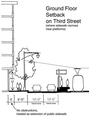 The narrowness of the Central Waterfront’s alleyways requires that development along them be carefully sculpted to proper proportions and to ensure that adequate light and air reach them and the frontages along them.
In addition to the building height and setback requirements stated in Policy 3.1.10 above, the building height at the property line along the southerly side of alleys must be setback so as to ensure a 45-degree sun access plane, as extended from the property line on the opposite side of the street to the top corner of each story.
Along both north-south and east west alleyways, setbacks are not required for the first 60 linear feet of the alley from the adjoining major street, as measured from the property line along the major street, so as to allow a proper streetwall along that street.
OBJECTIVE 3.2
PROMOTE AN URBAN FORM AND ARCHITECTURAL CHARACTER THAT SUPPORTS WALKING AND SUSTAINS A DIVERSE, ACTIVE AND SAFE PUBLIC REALM
Achieving an engaging public realm for the Central Waterfront is essential. While visual interest is key to a pedestrian friendly environment, current development practice does not always contribute positively to the pedestrian experience, and many contemporary developments detract from it. Seeing through windows to the activities within – be they retail, commercial, or PDR – imparts a sense of conviviality that blank walls or garage doors are unable to provide. Visually permeable street frontages offer an effective and engaging nexus between the public and private domains, enlivening the street, offering a sense of security and encouraging people to walk. Where there are residential uses, seeing the activities of living is key, represented by stoops, porches, entryways, planted areas, and windows that provide “eyes on the street.”
POLICY 3.2.1
Require high quality design of street-facing building exteriors.
-
Provide strong, repeating vertical articulation on new buildings, especially those with large street frontages, to achieve the visual interest necessary to sustain pedestrian interest and activity. Avoid undifferentiated massing longer than 25 feet on residential streets or alleys, and 40 feet on all other streets. Such vertical articulation as this cannot be satisfactorily achieved by minor changes such as change of color alone.
-
For vertically mixed-use buildings, changes in use should be visually differentiated through changes in material, scale, setback or other means, and not solely by color.
-
Building openings and fenestration should represent the uses behind them, minimize visual clutter, harmonize with prevailing conditions, and provide architectural interest. Windows should have a minimum recess of 3 inches, generally should be oriented, and open, vertically, and the frames should not be made of vinyl.
-
Use authentic materials with a substantial appearance, including wood, masonry, ceramic tile, pre-cast concrete or integrated stucco. Avoid using inauthentic materials, in particular those that have the appearance of thin veneer or attachment, such as EIFS or tilt-up panels. If used, inauthentic materials should not be the dominant façade material, and should not be used for detailing or ornamentation.
-
Brick, stone, tile, veneers or other applied materials should terminate logically and strongly, such as by wrapping corners and terminating at architectural modulations, articulations, frames or other features, so that they don’t appear superficially affixed to the façade.
-
Blank or blind frontages at the ground floor are highly discouraged and should be minimized wherever possible. Where necessary, frontages used for utilities, storage, refuse collection and other activities should be integrated into the overall articulation and fenestration of the façade, or be masked by landscaping or other design features where active uses are not possible.
-
Extended blank or blind frontages are not permitted along Transit Preferential Streets, even if alternative street or alley frontage is not available.
-
Horizontal articulation is required between the ground floor and second story. A minimum 6-inch projection is suggested. The human scale of the sidewalk is of paramount importance on neighborhood commercial streets. Architectural detailing, such as a belt course or cornice, at the ground floor ceiling height helps to frame the pedestrian space of the sidewalk.
POLICY 3.2.2
Make ground floor retail and PDR uses as tall, roomy and permeable as possible.
Maximize interior clear ceiling heights for ground floor retail or PDR uses. Where height districts end in five feet, such as 45’, 55’, 65’, and 85’, interior ground floor clear ceiling heights should maximize a fifteen foot envelope. This additional height will increase the flexibility of the space and improve its long-term viability.
Ground-level facades should be 75 percent transparent to permit a clear view inwards from the street and should not be tinted. Post construction alterations, such as retail displays, should not obscure the clear view.
POLICY 3.2.3
Minimize the visual impact of parking.
-
Where off-street parking is provided, placing it underground should be encouraged wherever site conditions allow, and especially for development on lots exceeding 5,000 square feet. Underground parking should be consolidated for multiple properties, where opportunities arise, thereby reducing the average cost of construction and minimizing the number of curb cuts and garage entrances.
-
At grade parking is strongly discouraged. Where at-grade parking is necessary, it should be wrapped with a minimum of 15 feet of active use, such as residential, retail, or PDR on both the primary and secondary street frontages, except for the minimum frontage required for fire doors and parking access.
-
For development with no more than 20 units, parking access should be provided by a single door not exceeding 8 feet. Where lot dimensions require separate ingress and egress, individual doors and driveways should not exceed a width of eight feet and should be separated by at least one foot.
-
For developments with more than 20 residential units but less than 100 residential units, individual doors and driveways should not exceed a width of 8 feet for ingress and 8 feet for egress, separated by one foot, and should not be widened to allow for off-street loading. Combined ingress and egress should not exceed 16 feet. More than one ingress and one egress or one combined ingress/egress access point should be discouraged.
-
For developments with 100 residential units or more, individual doors and driveways should not exceed a width of 8 feet for ingress and 8 feet for egress for auto parking, separated by one foot, and 10 feet for ingress and 10 feet for egress for joint parking and loading. Based on the conditions above, a combined ingress and egress should not exceed 20 feet. More than one ingress and one egress or one combined ingress/egress access point should be discouraged.
-
The number of curb cuts should be kept to an absolute minimum, with no more than one lane for ingress and one lane for egress, regardless of the total amount of parking proposed. Parking and loading should share access lanes, wherever possible, rather than requiring separate doors and driveways.
-
Curb cuts are prohibited on Transit Priority Streets (TPS), even if alternative street or alley frontage is not available.
-
Where a building has two frontages, parking entrances, loading docks, bays, and auxiliary service entrances should be accessed from secondary streets, and their visual impact on the neighborhood should be minimized.
POLICY 3.2.4
Strengthen the relationship between a building and its fronting sidewalk.
-
Buildings should embrace the public realm and the sidewalk, and set back only to accommodate elements that enhance this effect. Variations from this to accommodate wider sidewalks or front steps or stoops, create lively storefronts, or to mark entrances should be limited to the ground floor as defined elsewhere in these guidelines. In the case of Historic Dogpatch, where a pattern of building setbacks exists, the prevailing setback pattern should be respected. In the case of through-lots, concentrate massing along public rights of way and locate any open areas at the center of the lot.
-
Blank and blind walls at the ground floor are highly discouraged and should be minimized. Building frontage should not be used for utilities, storage, and refuse collection wherever possible; where this function must be on the street, landscaping and other well-integrated design features should be used to enhance the street frontage.
-
Ground-floor units should be primarily accessed directly from the public way, and not through common corridors or lobbies. Upper story units should connect to a lobby entry that opens directly onto the public way. Where possible, units should not only be accessed from an interior courtyard.
-
The individual entrances to ground-floor units should be set back 3-5 feet but no more than 10 feet from the street-fronting property line, and should be at least 18 inches, and ideally 3 feet, above sidewalk level.
-
All setback areas should maximize landscaping opportunities.
-
Utility vaults and access panels shall be placed in driveway curb cuts or at other locations so as to prevent blank building frontages and to ensure that sidewalk planting opportunities for street trees and landscaping are not limited.
-
Physically intimidating security measures such as window grills or spiked gates should be avoided; security concerns should be addressed by creating well-lit, well-used streets and active residential frontages that encourage “eyes on the street.”
-
The ground floor of new development along Third Street should be set back five feet from the property line to create wider sidewalks where the sidewalk narrows and curbside parking is absent alongside light rail platforms. To allow for more ample pedestrian space at transit nodes, a mandatory five-foot ground floor building setback is generally required along Third Street for parcels on the blocks on either side of the platforms at Mariposa, 20th, 23rd, and Marin Streets. This setback space must be free of columns or other significant pedestrian obstructions and should be treated as an extension of the sidewalk and allow public pedestrian passage. In order to avoid an undesirable “sawtooth” pattern of building setbacks (from a practical, aesthetic, and safety standpoint) due to the presence of buildings that are not likely to be redeveloped in the foreseeable future (such as historic structures, existing residential or large PDR buildings), the following guidelines with respect to setbacks should be followed:
POLICY 3.2.5
Building form should celebrate corner locations.
-
In use, design and entry, orient buildings towards corners.
-
Retail entrances should be located at corners, but primary residential entrances can be located away from the corner to prevent congestion.
-
Architectural features and detailing including towers, bays, and copulas at the corner are strongly encouraged.
-
Special building elements and architectural expressions such as towers, special entries, or cupolas should be used strategically at key locations, including street intersections and near important public spaces. They contribute to a building’s distinction as a landmark, help to define a gateway, draw attention to an important activity, or help define public gathering places. These elements must be integrated into the overall design of the building. Special corner treatments are encouraged for buildings that front onto the intersections of Third Street and Eighteenth Street, Twentith, and Twenety-second Street.
POLICY 3.2.6
Sidewalks abutting new developments should be constructed in accordance with locally appropriate guidelines based on established best practices in streetscape design.
In dense neighborhoods such as the Central Waterfront, streets can provide important and valued additions to the open space network, offering pleasurable and enjoyable connections for people between larger open spaces.
San Francisco’s Better Streets Plan will provide guidance on how to improve the overall urban design quality, aesthetic character, and ecological function of the city’s streets while maintaining the safe and efficient use for all modes of transportation. Changes to sidewalks should adhere to those in the Better Streets Plan.
POLICY 3.2.7
Strengthen the pedestrian network by extending alleyways to adjacent streets or alleyways wherever possible, or by providing new publicly accessible mid-block rights of way.
-
All buildings must have a maximum horizontal plan dimension of 110 feet, with a maximum diagonal of 125 feet. This standard is based on the walking speed of the average person and the need to experience diversity in the streetfront every ten to twenty paces. The form of new buildings must consider the proportions and massing of other residential and street-front commercial buildings found throughout San Francisco, which are typically based on 25-foot wide building increments for row houses and neighborhood retail frontages, and that generally do not exceed 75 feet in width for larger apartment or office buildings. Efforts should be made to integrate the building into the overall scale of the streetwall. Many of the development parcels in the plan area are wider than the traditional 25-foot lot pattern, and care must be taken to create a fine-grained human scale. Individual buildings should maintain an expression of architectural unity, even for larger buildings, within the 110 foot maximum dimension. There must be a qualitatively different expression of buildings between adjacent structures.
-
Developments on properties with 300 or more feet of street frontage on a block face longer than 400’ should provide a minimum 20-foot-wide publicly accessible mid-block right of way and access easement for the entire depth of the property, connecting to existing streets or alleys.
-
Developments on properties with 200 feet or more, but less than 300 feet of street frontage should be encouraged to provide a minimum 20-foot wide publicly accessible easement where doing so would reconnect an alley with an adjacent street or another alley.
-
Developments on properties with 100 feet or more, but less than 200 feet of street frontage in the middle one-third of a block face longer than 400’ where the adjacent property has the potential to do likewise, should be encouraged to provide a minimum 10-foot-wide publicly accessible mid-block right of way and access easement for the entire depth of the property, connecting to existing streets or alleys.
OBJECTIVE 3.3
PROMOTE THE ENVIRONMENTAL SUSTAINABILITY, ECOLOGICAL FUNCTIONING AND THE OVERALL QUALITY OF THE NATURAL ENVIRONMENT IN THE PLAN AREA
Given the reality of global climate change, it is essential that cities, and development within those cities, limit their individual and collective ecological footprints. Using sustainable building materials, minimizing energy consumption, decreasing storm water runoff, filtering air pollution and providing natural habitat are ways in which cities and buildings can better integrate themselves with the natural systems of the landscape. These efforts have the immediate accessory benefits of improving the overall aesthetic character of neighborhoods by encouraging greening and usable public spaces and reducing exposure to environmental pollutants.
Specific policies and design guidelines to address the objective outlined above are as follows:
POLICY 3.3.1
Require new development to adhere to a new performance-based ecological evaluation tool to improve the amount and quality of green landscaping.
The San Francisco Planning Department, in consultation with the Public Utilities Commission, is in the process of developing a green factor. The green factor will be a performance-based planning tool that requires all new development to meet a defined standard for on-site water infiltration, and offers developers substantial flexibility in meeting the standard. A similar green factor has been implemented in Seattle, WA, as well as in numerous European cities, and has proven to be a cost-effective tool, both to strengthen the environmental sustainability of each site, and to improve the aesthetic quality of the neighborhood. The Planning Department will provide a worksheet to calculate a proposed development’s green factor score.
POLICY 3.3.2
Discourage new surface parking lots and explore ways to encourage retrofitting existing surface parking lots and off-street loading areas to minimize negative effects on microclimate and stormwater infiltration. The city’s Stormwater Master Plan, upon completion, will provide guidance on how best to adhere to these guidelines.
POLICY 3.3.3
Enhance the connection between building form and ecological sustainability by promoting use of renewable energy, energy-efficient building envelopes, passive heating and cooling, and sustainable materials.
POLICY 3.3.4
Compliance with strict environmental efficiency standards for new buildings is strongly encouraged.
The positive relationship between building sustainability, urban form, and the public realm has become increasingly understood as these buildings become more commonplace in cities around the world. Instead of turning inwards and creating a distinct and disconnected internal environment, sustainable buildings look outward at their surroundings as they allow in natural light and air. In so doing, they relate to the public domain through architectural creativity and visual interest, as open, visible windows provide a communicative interchange between those inside and outside the building. In an area where creative solutions to open space, public amenity, and visual interest are of special need, sustainable building strategies that enhance the public realm and enhance ecological sustainability are to be encouraged.
OBJECTIVE 3.4
ENSURE FUTURE PLANNING AND DEVELOPMENT ADDRESS THE NEED TO MITIGATE AND RESPOND TO FUTURE HAZARDS, PARTICULARLY THOSE CAUSED BY SEA LEVEL RISE AND CLIMATE CHANGE
POLICY 3.4.1
Engage the community on an ongoing basis when adapting land use and development policies to mitigate and reduce hazard risks associated with Sea Level Rise.
In August 2021, the City and the Port published the Islais Creek Southeast Mobility Adaptation Strategy (ICSMAS), which examined the Creek and its surrounding neighborhood’s flood hazard risks and identified a comprehensive suite of possible adaptation pathways to protect the area and its key public assets from flooding and permanent inundation. The ICSMAS describes community engagement, methodology, and recommendations that could be used as a template and starting point for future ongoing planning and community engagement to address SLR-related hazard risk around Islais Creek.
4. Transportation
NOTE: The following Transportation objectives and policies relate specifically to the transportation system. Objectives and policies related to physical street design can be found in the Streets and Open Space chapter.
The gritty, industrial character of the Central Waterfront extends to the transportation system serving it. The challenge is to preserve the essential character of the neighborhood while supporting a full, equitable range of choices for the movement of people and goods to, within, and from the Central Waterfront. Access to transportation, particularly alternatives to the private automobile, must be knitted into the fabric of the neighborhood and everyday services promoted to reduce the need to travel.
Ongoing improvements to the operation of the new Third Street Light Rail line will continue to improve the accessibility of the area by transit. New commercial and residential development will support basic services and reduce the need to travel outside the neighborhood. The Central Waterfront’s transportation infrastructure must continue to cater to industrial uses while also reducing conflicts that heavy freight traffic creates with other road users such as bicyclists and pedestrians.
OBJECTIVE 4.1
IMPROVE PUBLIC TRANSIT TO BETTER SERVE EXISTING AND NEW DEVELOPMENT IN CENTRAL WATERFRONT
The Central Waterfront is well served by both local and regional transit. In early 2007, Muni’s Third Street Light Rail entered revenue service, providing a direct link north to downtown and south to Bayview/Hunters Point and Visitacion Valley. The 22nd Street Caltrain Station provides regional connections south to the South Bay and Silicon Valley. While the majority of transit service and ridership in the Central Waterfront is along north-south corridors, the need remains to improve cross-town routes. As the number of workers and residents in the neighborhood increases, the cross-town routes also play an important role as feeder routes to the Third Street Light Rail.
In 2011, the San Francisco Municipal Transportation Agency (SFMTA), Planning Department and the San Francisco County Transportation Authority (SFCTA) completed a comprehensive Eastern Neighborhoods Transportation Implementation Planning Study (EN TRIPS) that explored the feasibility of the options described above, determine which projects are needed, how they should be designed and how they can be funded. A key input to this was SFMTA’s Muni Forward Project, which was the first comprehensive study of the Muni system since the late 1970s. Muni Forward promoted overall performance and long-term financial stability through faster, more reliable transportation choices and cost-effective operating practices. In 2021, the multiagency transportation planning collaboration ConnectSF produced a Transit Strategy, which describes the major capital projects and programs that will help San Francisco’s transit system meet the existing and future travel needs of residents, workers, and visitors.
The policies to address the objective outlined above are as follows:
POLICY 4.1.1
Commit resources to an analysis of the transportation impacts of new zoning and mobility needs in the Central Waterfront to develop a plan that prioritizes transit while addressing needs of all modes (auto circulation, freeway traffic, bicyclists, pedestrians).
This policy refers to the Eastern Neighborhoods Transportation Implementation Planning Study (EN TRIPS) described above.
POLICY 4.1.2
Decrease transit travel time and improve reliability through a variety of means, such as transit-only lanes, transit signal priority, transit “queue jumps,” lengthening of spacing between stops, and establishment of limited or express service.
POLICY 4.1.3
Continue to support the service recommendations of the Muni Forward program and the recommendations of the ConnectSF Transit Strategy.
POLICY 4.1.4
Reduce existing curb cuts where possible and restrict new curb cuts to prevent vehicular conflicts with transit on important transit and neighborhood commercial streets.
Curb cuts should be reduced on key neighborhood commercial, pedestrian, and transit streets, where it is important to maintain continuous active ground floor activity, protect pedestrian movement and retail viability, and reduce transit delay and variability. This is a critical measure to reduce congestion and conflicts with pedestrians and transit movement along Transit Preferential Streets, particularly where transit vehicles do not run in protected dedicated rights-of-way and are vulnerable to disruption and delay. Curb cuts are currently restricted along Third Street.
POLICY 4.1.5
Ensure Muni’s storage and maintenance facility needs are met to serve increased transit demand and provide enhanced service.
Additional transit vehicles will be needed to serve new development in the Eastern Neighborhoods. The capacity of existing storage and maintenance facilities should be expanded and new facilities constructed to support growth in the Eastern Neighborhoods. Address the need to mitigate and respond to possible future hazards, particularly related to SLR, in Muni’s ongoing planning for, and maintenance and future rehabilitation of, such facilities.
POLICY 4.1.6
Improve public transit in the Central Waterfront including cross-town routes and connections the 22nd Street Caltrain Station and Third Street Light Rail.
OBJECTIVE 4.2
INCREASE TRANSIT RIDERSHIP BY MAKING IT MORE COMFORTABLE AND EASIER TO USE
A transit rider’s experience is largely impacted by the quality of environment in and around the stops and stations where they start or end their transit trips. Transit stops can be made more attractive and comfortable for riders through installation of bus bulbs, shelters, additional seating, lighting, and landscaping. Pedestrian safety should also be prioritized near transit through the installation and maintenance of signs, crosswalks, pedestrian signals and other appropriate measures. Quality passenger information and accurate real-time transit information should be provided. Key transit stops with high passenger volumes or high transfer volumes should be prioritized for enhanced amenities. The stations along the Third Street Light Rail line reflect their importance through unique shelter designs, artwork and real-time transit information.
Areas for improvement include the Caltrain Station at 22nd Street & Pennsylvania Avenue. The station is unpleasant and provides few amenities. Shelter is provided by the overhead freeway. An open drainage ditch runs down the edge of the platform. Set 20 feet below grade between two dark tunnels, absolutely no “natural surveillance” can be provided by occupied windows or passing traffic, creating a space that is frightening for many users, particularly late at night. A major opportunity exists to better integrate the Caltrain Station at 22nd Street into the Central Waterfront through good design. In addition, the station’s presence in the neighborhood needs to be made more prominent, through street treatments and signage on pedestrian routes to and from the station. Improvements to personal safety such as the removal of potential “lurking spaces” in and around the station area, lighting improvements, the installation of emergency call boxes, and similar changes should also be addressed.
POLICY 4.2.1
Improve the safety and quality of streets, stops and stations used by transit passengers.
POLICY 4.2.2
Provide comprehensive and real-time passenger information, both on vehicles and at stops and stations.
OBJECTIVE 4.3
ESTABLISH PARKING POLICIES THAT IMPROVE THE QUALITY OF NEIGHBORHOODS AND REDUCE CONGESTION AND PRIVATE VEHICLE TRIPS BY ENCOURAGING TRAVEL BY NON-AUTO MODES
Limited on-street parking is available in the Central Waterfront north of 23rd Street. However, this is largely due to the absence of any form of parking management. Relatively few on-street parking spaces in the Central Waterfront have any sort of restriction or designation—parking meters, residential permit restrictions, or time restrictions. South of 23rd Street, occupancy drops as the density falls and the neighborhood becomes more industrial. As the neighborhood develops, on street parking in this area should be managed more like parking elsewhere in the city. Meters, residential permit parking zones, pricing policies, and time limits must be used to give priority to residents and customers over other users, particularly commuters.
Many of the goals and objectives of this Plan depend heavily on how parking – both on and off street – is managed in the Central Waterfront. These goals include reduced congestion and private vehicle trips, improved transit, vibrant neighborhood commercial districts, housing production and affordability, and good urban design.
Elimination of minimum off-street parking requirements in new residential and commercial developments, while continuing to permit reasonable amounts of parking if desired, allows developers more flexibility in how they choose to use scarce developable space. In developments where space permits or where expected residents would particularly desire to own cars, parking can be provided, while in transit intensive areas, or where expected residents would not need cars (senior developments for example) parking would not be required. Space previously dedicated to parking in residential developments can be made available for additional housing units. With no parking minimums and therefore no need for individual drive-in parking spaces, new residential and commercial developments can explore more efficient methods of providing parking such as mechanical parking lifts, tandem or valet parking.
“Unbundling” parking from housing costs can reduce the cost of housing and make it more affordable to people without automobiles. The cost of parking is often aggregated in rents and purchase prices. This forces people to pay for parking without choice and without consideration of need or the many alternatives to driving available. This could be avoided by requiring that parking be separated from residential or commercial rents, allowing people to make conscious decisions about parking and auto ownership.
Proper management of public parking, both on-street and in garages is critical. Currently, on-street parking is difficult to find in many parts of the city. Loose regulation and relatively inexpensive rates increase demand and decrease turnover of parking spaces. This shifts demand away from public transit and other modes, increases congestion and encourages long term on-street parking by employees and commuters. To support the needs of businesses and create successful commercial areas, on-street parking spaces should be managed to favor short-term shoppers, visitors, and loading. In residential areas, curbside parking should be managed to favor residents, while allocating any additional spaces for short-term visitors to the area. Recent research has proposed a number of ways to use market-based pricing and other innovative management techniques to improve availability of on-street parking while also increasing the revenue stream to the city. These methods are currently under study and should be applied in this area.
In accordance with Section 8A.113 of Proposition E (2000), new public parking facilities can only be constructed if the revenue earned from a new parking garage will be sufficient to cover construction and operating costs without the need for a subsidy. New development built with reduced parking could accommodate parking needs of drivers through innovative shared parking arrangements like a “community parking garage.” Located outside of neighborhood commercial and small scale residential areas, such a facility would consolidate parking amongst a range of users (commercial and residential) while providing an active ground floor featuring neighborhood services and retail.
The policies to address the objective outlined above are as follows:
POLICY 4.3.1
For new residential development, provide flexibility by eliminating minimum off-street parking requirements and establishing reasonable parking caps.
POLICY 4.3.2
For new non-residential development, provide flexibility by eliminating minimum off-street parking requirements and establishing caps generally equal to the previous minimum requirements. For office uses limit parking relative to transit accessibility.
POLICY 4.3.3
Make the cost of parking visible to users, by requiring parking to be rented, leased or sold separately from residential and commercial space for all new major development.
POLICY 4.3.4
Encourage, or require where appropriate, innovative parking arrangements that make efficient use of space, particularly where cars will not be used on a daily basis.
POLICY 4.3.5
Permit construction of public parking garages in Mixed Use districts only if they are part of shared parking arrangements that efficiently use space, are appropriately designed, and reduce the overall need for off-street parking in the area.
POLICY 4.3.6
Reconsider and revise the way that on-street parking is managed in both commercial and residential districts in order to more efficiently use street parking space and increase turnover and parking availability.
The San Francisco County Transportation Authority is conducting the On-Street Parking Management and Pricing Study to evaluate a variety of improved management techniques for on-street parking and recommend which should be put into effect in San Francisco.
OBJECTIVE 4.4
SUPPORT THE CIRCULATION NEEDS OF EXISTING AND NEW PDR AND MARITIME USES IN THE CENTRAL WATERFRONT
In the areas south of 23rd Street and generally east of Third Street the needs of industry should be prioritized while still accommodating pedestrians, bicyclists and cars. Along many of these streets, the entire width of the rights-of-way is used for truck maneuvering, loading, and parking. These activities must be allowed to continue if industrial activities are to remain viable. Loading docks should be allowed to face the street with the expectation that trucks will partially block the public right-of-way while loading. There should be fewer restrictions against curb cuts in these areas; sidewalks and street trees should not be required where their presence would conflict with truck operations.
The city should evaluate the existing on-street curb-designation for delivery vehicles and improve daytime enforcement to increase turnover. Where necessary, curbside freight loading spaces should be increased. During evenings and weekends, curbside freight loading spaces should be made available for visitor and customer parking. In new non-residential developments, adequate loading spaces internal to the development should be required to minimize conflicts with other street users.
The policies to address the objective outlined above are as follows:
POLICY 4.4.1
Provide an adequate amount of short-term, on-street curbside freight loading spaces in PDR areas of the Central Waterfront.
POLICY 4.4.2
Continue to require off-street facilities for freight loading and service vehicles in new large non-residential developments.
POLICY 4.4.3
In areas with a significant number of PDR establishments and particularly along Illinois Street, design streets to serve the needs and access requirements of trucks while maintaining a safe pedestrian and bicycle environment.
POLICY 4.4.4
Allow existing street encroachments in public rights-of-way to continue if their use will not significantly detract from efficient and safe public use of the street, and the use of the existing development presents strong justifications for occupying the street area.
New street encroachments into the public right-of-way, even for industrial uses, should not be permitted. However, many existing industrial structures in the area have features, such as loading docks, that encroach beyond the property lines. If these encroachments are necessary to support the functional use of the existing structures for industrial use, they should be allowed to remain, as long as industrial use of the adjacent privately-owned property is maintained.
Should the use of the adjacent privately-owned property change and no longer support industrial use, the City should rescind the encroachment permit of the adjacent public right-of-way. If structures on the adjacent property are proposed to be demolished, enlarged or substantially renovated, the City should rescind the encroachment permit and require the private property owner to reconfigure uses and incorporate the private use of the right-of-way within the privately-owned property.
The City should rescind an encroachment permit if the use of the public right-of-way has changed from the original approved use.
POLICY 4.4.5
Maintain and enhance rail access to maritime facilities.
Freight rail is important to the attraction and retention of active maritime uses along the waterfront. The new rail bridge across Islais Creek at Illinois Street will accommodate freight rail in Central Waterfront. The bridge will provide direct freight rail and vehicle access to Pier 80 and a goods movement terminal south of Islais Creek linking the Port’s cargo shipping facilities. The Illinois Street Bridge will also underscore the role of Illinois Street as a major trucking and freight movement route. This new bridge will allow freight trains to use an existing rail right-of-way from the mainline to Cargo Way, then up Illinois Street to Pier 70.
OBJECTIVE 4.5
CONSIDER THE STREET NETWORK IN CENTRAL WATERFRONT AS A CITY RESOURCE ESSENTIAL TO MULTI-MODAL MOVEMENT AND PUBLIC OPEN SPACE
Not only are the Central Waterfront’s streets essential for the movement of people and goods they are also an essential component of our public realm and open space network. Streets are the city’s most important and ubiquitous civic open space. They are the primary place for people to meet and socialize, stroll, contemplate vistas, peer in storefronts, and absorb the diversity that the city has to offer around each corner.
One of the key design goals of this plan is to augment and enrich the public street and pathway system. The Central Waterfront’s street grid should be extended to break up large parcels into human-scaled city-scale blocks and facilitate greater access to all areas of the neighborhood. In areas where the street cannot be extended due to topography, preservation of historical features, or other factors, the “line of the grid” should be extended through building placement and, if possible, pathways to ensure the continuation of sight lines and pedestrian access. In the plan area, the grid is also a key tool to reconnect the area’s open spaces, waterfront, retail areas, and transit services with one another and to create a walkable place.
The Central Waterfront contains a number of public right-of-ways that have, over the years, been abandoned or allowed to be incorporated into private parcels. These are more appropriately used to support the public realm, as part of the system of public ways. Recovering these right-of-ways is especially important in the Central Waterfront because of the dearth of public space. The city should not vacate or sell this public space to private interests unless it is determined that removing excess roadway or reconfiguration of specific intersection geometries will achieve significant public benefits such as increased traffic or pedestrian safety and public open space. New developments on large lots should also be required to provide alleys to break up the scale of the building and allow greater street connectivity.
The policies to address the objective outlined above are as follows:
POLICY 4.5.1
Maintain a strong presumption against the vacation or sale of streets or alleys except in cases where significant public benefits can be achieved.
POLICY 4.5.2
As part of a development project’s open space requirement, require publicly-accessible alleys that break up the scale of large developments and allow additional access to buildings in the project.
POLICY 4.5.3
Redesign underutilized streets not needed for PDR business circulation needs in the Central Waterfront for creation of Living Streets and other usable public space.
POLICY 4.5.4
Extend and rebuild the street grid, especially in the direction of the Bay.
The Bay is an incredible natural asset, yet the Central Waterfront now has little access to the waterfront because of large parcelization and Port and industrial uses that do not allow many streets to penetrate through to or follow the water’s edge. Extending east-west streets to the water’s edge to facilitate public access and siting new structures so as not to obstruct public views down rights-of-way to the water’s edge is encouraged as large properties and Port lands redevelop. Where historic structures would block the straight extension of rights-of-way (such as 20th and 22nd Streets), roads or paths should bend around the structures, though public pedestrian access through the structures should be explored. The specific design of these streets should be considered in the context of the Pier 70 planning process and not conflict with any established policies.
POLICY 4.5.5
Reclaim public rights-of-way that have been vacated or incorporated into private parcels.
OBJECTIVE 4.6
SUPPORT WALKING AS A KEY TRANSPORTATION MODE BY IMPROVING PEDESTRIAN CIRCULATION WITHIN CENTRAL WATERFRONT AND TO OTHER PARTS OF THE CITY
As an industrial and maritime area, the Central Waterfront has historically provided an environment unfriendly to pedestrians. The Central Waterfront’s incomplete street grid, limited waterfront access, truck traffic, and large land parcels provide challenges to pedestrian access and circulation. However, this is changing. The completion of the Third Street Light Rail and related street upgrades like pedestrian countdown signals and new curb ramps along Third Street have helped create a friendlier environment for pedestrians. Efforts to make the Central Waterfront an increasingly walkable place should continue. Extending the street grid and creating human-scaled city blocks can help further establish pedestrian comfort in Central Waterfront. Improving pedestrian connections between the Central Waterfront and surrounding neighborhoods is also important to create strong pedestrian links. The Bay Trail and Blue Greenway present opportunities to further establish the Central Waterfront as a place to walk with recreation paths.
The policies to address the objective outlined above are as follows:
POLICY 4.6.1
Use established street design standards to make the pedestrian environment safer and more comfortable for walk trips.
POLICY 4.6.2
Prioritize pedestrian safety improvements at intersections and in areas with historically high frequencies of pedestrian injury collisions.
POLICY 4.6.3
Improve pedestrian access to transit stops including Third Street light rail and the 22nd Street Caltrain Station.
POLICY 4.6.4
Facilitate improved pedestrian crossings at several locations to better connect the Central Waterfront and surrounding areas – Potrero Hill, Mission Bay, and Showplace Square.
POLICY 4.6.5
Facilitate completion of the sidewalk network in Central Waterfront, especially where new development is planned to occur.
POLICY 4.6.6
Explore opportunities to identify and expand waterfront recreational trails and opportunities including the Bay Trail.
The Association of Bay Area Governments’ (ABAG) Bay Trail project is a planned recreational corridor that, when complete, will encircle San Francisco and San Pablo Bays with a continuous 400-mile network of bicycling and hiking trails. At present, much of the Bay Trail extends along Third Street and Illinois Street. Created in 2012, the Blue Greenway open space guidelines and network through the Central Waterfront promote parks and public access that extends to and along the waterfront, integrated in new mixed use developments while respecting space needs of industrial and maritime uses. Signs for spur trails to new and improved public open spaces and shoreline access at Islais Creek, Warm Water Cove, Irish Hill, and Pier 70 should be placed and included in the Bay Trail maps and literature.
OBJECTIVE 4.7
IMPROVE AND EXPAND INFRASTRUCTURE FOR BICYCLING AS AN IMPORTANT MODE OF TRANSPORTATION
The Central Waterfront plays a critical role in creating a continuous, safe, comfortable bicycle connection between downtown and the Bayview/Hunters Point. It is flat and provides direct routes between the two areas. Given the Mission Bay development to the north, the best bike corridors through the Central Waterfront are Indiana and Illinois Streets. Indiana Street provides direct access to the 22nd Street Caltrain Station, Esprit Park, and Islais Creek open space. Illinois Street improvements would connect to downtown via Terry Francois Boulevard, and to Bayview/Hunters Point via the Illinois Street bridge over Islais Creek.
The SFMTA is studying these corridors, as well as Minnesota Street, for bicycle improvements that will facilitate safer north-south connections. Potential east-west bicycle improvements include, but are not limited to, changes on Cesar Chavez Street and Mariposa Street. Additional bicycle connections have been created in Pier 70 to connect new development and Blue Greenway open spaces to the city street grid and public realm. Bicycle access and improvements should be carefully designed with respect to Central Waterfront industrial and truck operations as addressed in Objective 4.4.
The policies to address the objective outlined above are as follows:
POLICY 4.7.1
Provide a continuous network of safe, convenient and attractive bicycle facilities connecting Central Waterfront to the citywide bicycle network that conforms with the San Francisco bicycle policies and is designed for safety on streets that serve industrial business and vehicular traffic.
POLICY 4.7.2
Provide secure, accessible and abundant bicycle parking, particularly at transit stations, within shopping areas and at concentrations of employment.
POLICY 4.7.3
Support the establishment of the Blue-Greenway by including safe, quality pedestrian and bicycle connections from Central Waterfront.
The vision for the “Blue Greenway” is to create a 13-mile greenway network along San Francisco’s Southern Waterfront, completing San Francisco’s portion of the Bay Trail, increasing public enjoyment of this historic, working waterfront, and providing much-needed open space, water access, and a walking/biking route to San Francisco’s eastern neighborhoods.
OBJECTIVE 4.8
ENCOURAGE ALTERNATIVES TO CAR OWNERSHIP AND THE REDUCTION OF PRIVATE VEHICLE TRIPS
In addition to investments in our transportation infrastructure, there are a variety of programmatic ways in which the city can encourage people to use alternative modes of travel. Car sharing and transportation demand management programs (TDM) are important tools to reduce congestion and limit parking demand.
Carsharing offers an affordable alternative to car ownership by allowing individuals the use of a car without the cost of ownership (gas, insurance, maintenance). Carsharing companies provide privately owned and maintained vehicles for short-term use by their members. Carshare members pay a flat hourly rate or monthly fee to use cars only when they need them (i.e. to run errands or make short trips).
Recent zoning code changes require carshare spaces in new residential developments. Locating carshare spaces and vehicles in new and existing developments helps to provide an attractive and convenient alternative to automobile ownership. As a dense neighborhood with good access to local and regional transit, additional spaces in Central Waterfront should be encouraged.
Transportation Demand Management (TDM) combines marketing and incentive programs to reduce dependence on automobiles and encourage use of a range of transportation options, including public transit, bicycling, walking and ridesharing. Potential TDM programs employers should introduce in the Eastern Neighborhoods include “Cash-out” policies (where employers provide cash instead of a free parking space), Commuter Checks and Emergency Ride Home programs.
Businesses and institutions with large numbers of employees or students should be required to develop on-site transportation demand management programs or join in a larger area-wide program such as San Francisco Transportation Management Association (TMA). Major residential developments (50+ units) could be required to provide transit passes to all residents as part of rent or homeowner association fees.
The policies to address the objective outlined above are as follows:
POLICY 4.8.1
Continue to require car-sharing arrangements in new residential and commercial developments, as well as any new parking garages.
POLICY 4.8.2
Require large retail establishments, particularly supermarkets, to provide shuttle and delivery services to customers.
POLICY 4.8.3
Implement the Citywide Transportation Demand Management (TDM) program for the Eastern Neighborhoods that provides information and incentives for employees, visitors and residents to use alternative transportation modes and travel times.
OBJECTIVE 4.9
FACILITATE MOVEMENT OF AUTOMOBILES WHILE STRIVING TO REDUCE NEGATIVE IMPACTS OF VEHICLE TRAFFIC
New development in Central Waterfront will generate additional travel in and through the area. Since many new trips in the area are expected to occur by public transit, walking and biking, efforts should be made to accommodate new vehicle traffic while reducing conflicts with pedestrians or transit. Traffic calming projects such as those underway in nearby Potrero Hill should be implemented and expanded to reduce speeding and improve neighborhood livability. New technologies such as those being developed by the Department of Parking and Traffic’s “SFGO” program should be pursued to reduce congestion, respond to current traffic conditions and move autos safely and efficiently.
The policies to address the objective outlined above are as follows:
POLICY 4.9.1
Introduce traffic calming measures where warranted to improve pedestrian safety and comfort, reduce speeding and traffic spillover from arterial streets onto residential streets and alleyways.
POLICY 4.9.2
Decrease auto congestion through implementation of Intelligent Traffic Management Systems (ITMS) strategies such as smart parking technology, progressive metering of traffic signals and the SFMTA “SFGO” program.
OBJECTIVE 4.10
DEVELOP A COMPREHENSIVE FUNDING PLAN FOR TRANSPORTATION IMPROVEMENTS
New development in Central Waterfront and throughout the Eastern Neighborhoods will exert significant strain on the area’s existing transportation infrastructure. The city must develop new funding sources and a funding plan to ensure needed improvements are made.
Transportation improvements are costly. While federal, state, regional and local grant sources are available to partially defray the cost of transportation capital projects, they are not sufficient to meet transportation needs identified by the community. Streets and transportation improvements (pedestrian, bicycle, and transit) will require a significant portion of the funding generated through the Eastern Neighborhoods Public Benefits Program. Because funds from this program will also be needed to support a number of other community improvements beside transportation, it will be important to identify additional sources of funding.
The policies to address the objective outlined above are as follows:
POLICY 4.10.1
As part of the Eastern Neighborhoods Public Benefits Program, pursue funding for transit, pedestrian, bicycle and auto improvements through developer impact fees, in-kind contributions, community facilities districts, dedication of tax revenues, and state or federal grant sources.
MAP 3 – Eastern Neighborhoods Public Transit Improvements Concept
MAP 4 – Eastern Neighborhoods Pedestrian/Bicycle/Traffic Calming Improvements
5. Streets & Open Space
Central Waterfront has had a deficiency of open spaces serving the neighborhood. Given that much of Central Waterfront is transitioning from industrial to mixed-use, notable portions of Central Waterfront are not within walking distance to an existing park and many areas lack adequate places to recreate and relax. With the addition of new workers and residents, this deficiency will only be exacerbated. Thus, one of the primary objectives of this Plan is to provide more open space to serve both existing and new residents, workers and visitors. Outside of Pier 70 and Potrero Power Station, which together propose roughly nine acres of new open space, this Plan proposes to provide this new open space by creating at least one substantial new park site (or more than one smaller open spaces commensurate to one substantial new park) in Central Waterfront. In addition, the Plan proposes to encourage some of the private open space that will be required as part of development to be provided as public open space and to utilize our existing rights-of-way to provide pocket parks.
OBJECTIVE 5.1
PROVIDE PUBLIC PARKS AND OPEN SPACES THAT MEET THE NEEDS OF RESIDENTS, WORKERS AND VISITORS
In a built-out neighborhood such as this, finding sites for sizeable new parks is difficult. However, it is critical that at least one new substantial open space be provided as part of this Plan. This Plan identifies a number of potential park sites: the area behind the IM Scott School site, which is currently used for parking, expansion of Warm Water Cove and the development of Crane Cove Park north of Pier 70. Additionally, as part of a new development at the former Potrero Power Plant and the Pier 70 Special Use District sites, the Bay shoreline will be improved with bayfront parks, pathways, and public access connecting the Bay Trail through these areas. The area surrounding Irish Hill is also identified as a potential park site.
The City is working with the San Francisco Unified School District on the IM Scott School site and with the Port of San Francisco to develop Crane Cove Park, and the City suppports the renovation and expansion of Warm Water Cove. The Port sites greatly expand public access to the waterfront and provide large areas of public open space. Crane Cove Park, located at 19th and Illinois Street, includes over 1,200 feet of Bay edge access, two cranes, and a small boat/aquatic center. This major new waterfront park adjacent to the Pier 70 shipyard is integrated with the restoration of the historic maritime structures. Also envisioned is the renovation and future expansion of Warm Water Cove, a small landscaped picnic area at the end of 24th Street adjacent to the Bay. The new master planned development at Pier 70 and the Potrero Power Station will provide multiple acres of open space along the waterfront and internal to the two sites.
As a result of the Pier 70 planning processes, the remnant of Irish Hill swill be incorporated into the open space network. Irish Hill was once a prominent feature of the Central Waterfront, serving as the home for workers in the nearby mills from the 1880s until World War I, when the hill was mostly leveled to make way for expansion of the shipyards. While little of the original bluff remains, it is an unusual reminder of the area’s history.
In order to provide a public park, significant funding will need to be identified to acquire, develop, and maintain the spaces. One source of funds would be impact fees or direct contributions from new development. New residential development directly impacts the existing park sites with its influx of new residents, therefore new residential development will be required to either pay directly into a fund to acquire new open space or provide publicly accessible space on or off-site. Funding for the planned Port open spaces is also needed. The Port, with the Recreation and Parks Department, will propose future open space bonds, which could partially cover the cost of improvements to Warm Water Cove and an expanded Crane Cove Park, but additional funding sources will need to be found to ensure the development of these open spaces.
Commercial development also directly impacts existing park sites, with workers, shoppers and others needing places to eat lunch and take a break outside. This Plan also proposes to charge an impact fee for commercial development to cover the impact of proposed commercial development.
The policies to address the objective outlined above are as follows:
POLICY 5.1.1
Identify opportunities to create new public open spaces and provide at least one new public open space serving the Central Waterfront.
POLICY 5.1.2
Require new residential and commercial development to provide, or contribute to the creation of public open space.
OBJECTIVE 5.2
ENSURE THAT NEW DEVELOPMENT INCLUDES HIGH QUALITY PRIVATE OPEN SPACE
In addition to the publicly accessible open space requirements, another tool for making Central Waterfront greener is to require additional private open space. Currently residential developments are required to provide open space accessible to residents. In Central Waterfront this requirement is currently much lower than any other neighborhood in the city where residential uses are allowed. This Plan increases the open space required as part of new developments to be similar to what is currently required in other neighborhoods.
Additionally, commercial development is currently required to provide open space in SoMa. These existing requirements establish a minimum amount of open space to be provided on-site, or project sponsors may elect to pay an in-lieu fee. Because these fees are low, project sponsors often elect to pay the fee. This plan proposes to reexamine the current requirements for commercial development in SoMa to provide adequate, usable open space, and it proposes to encourage publicly accessible open space as part of new residential and commercial development in the Central Waterfront.
In small-scale residential developments, for example the Dogpatch neighborhood, open space is provided as backyards. Taken together in the center of a block, these rear yards provide a sense of visual relief and access to open space in this part of the city. In areas where the existing pattern is one of rear yards, this pattern should be maintained. However, in areas where rear yards do not predominate, new residential developments should provide open space in a manner that best fits the characteristics of the particular site, while still ensuring high quality open space design.
The quality of the private open space is also being reexamined in the Central Waterfront. Currently, open space is often provided as sterile hardscape atop a building’s podium. By employing the new performance-based evaluation tool, discussed in greater detail in the Built Form section of this Area Plan, this required open space will be made greener, more ecologically sustainable, and more enjoyable for residents.
The policies to address the objective outlined above are as follows:
POLICY 5.2.1
Require new residential and mixed-use residential development to provide on-site private open space designed to meet the needs of residents.
POLICY 5.2.2
Establish requirements for commercial development to provide on-site open space.
POLICY 5.2.3
Encourage private open space to be provided as common spaces for residents and workers of the building wherever possible.
POLICY 5.2.4
Encourage publicly accessible open space as part of new residential and commercial development.
POLICY 5.2.5
New development will respect existing patterns of rear yard open space. Where an existing pattern of rear yard open space does not exist, new development on mixed-use-zoned parcels has flexibility as to where open space can be located.
POLICY 5.2.6
Ensure quality open space is provided in flexible and creative ways, adding a well used, well-cared for amenity for residents of a highly urbanized neighborhood. Private open space should meet the following design guidelines:
-
Designed to allow for a diversity of uses, including elements for children, as appropriate.
-
Maximize sunlight exposure and protection from wind
-
Adhere to the performance-based evaluation tool.
In new mixed-use developments, common, unenclosed residential open space areas can be provided as a rear yard, rooftop garden, central courtyard, balcony, or elsewhere on the lot or within the development so long as it is clearly accessible and usable by residents. Landscaping visible from the street is encouraged. Common spaces are encouraged over private spaces.
OBJECTIVE 5.3
CREATE A NETWORK OF GREEN STREETS THAT CONNECTS OPEN SPACES AND IMPROVES THE WALKABILITY, AESTHETICS, AND ECOLOGICAL SUSTAINABILITY OF THE NEIGHBORHOOD
In a built out neighborhood such as Central Waterfront, acquiring sites for new large parks can be difficult. For this reason, in addition to the acquisition of at least one park site in the neighborhood, the Central Waterfront Area Plan proposes an open space network of “Green Connector” streets, with wider sidewalks, places to sit and enjoy, significant landscaping, and gracious street trees that would provide linkages between larger open spaces and diffuse the recreational and aesthetic benefits of these spaces into the neighborhood. Specifically, this Plan proposes to create a greenway along 24th Street that will connect Warm Water Cove to the rest of the neighborhood. At 100 feet, the 24th Street right-of-way between the water and Michigan Street is wider than a typical street width, offering the opportunity for landscaping and greening elements to connect the park more strongly to Third Street and to attract more users from Third Street. Additional green Connector streets are proposed along Minnesota Street to connect Esprit Park, to Muni Park and passing the proposed IM Scott school site park. Third Street also represents an important street with the light rail and pedestrian activity on this street. Additionally, 22nd Street connecting the Central Waterfront neighborhood to new neighborhood and waterfront public access in the Pier 70 Special Use District provides an opportunity for greening. Proposed landscaping and greening improvements would enhance this streetscape.
Public access to Islais Creek is also in need of improvement. Currently, there are two access points: the north side of Tennessee Street is a hardscaped area that covers a sewage outfall facility and the south side of the creek is a handicap-accessible put-in for non-motorized watercraft. On the east side of the Third Street Bridge is Tulare pocket park. None of these spaces are well used (except by skateboarders, who use the outfall cover) because they are not easily reached, are small, and feel isolated and disconnected. As much as possible, future development should be required to contribute to the creation of a continuous loop of publicly accessible open space, and should themselves help to activate it. The loop should run from Illinois Street west along the northern edge of the creek, turning at the end of the creek to run east along the southern edge, ending at the 3rd Street Bridge. Future improvements to Islais Creek and its adjacent open spaces and infrastructure should include features and programs that address possible future flooding and inundation caused by Sea Level Rise and climate change.
The area marking the historic alignment of the Tubbs Cordage Factory has been developed into a public pedestrian passage that connects Tennessee and Third Streets. Now constructed, this improves the connection between the Caltrain station and the 23rd Street light rail stop. (See Map 5 – Eastern Neighborhoods Streets and Open Space Concept Map)
Streets can and should provide important and valued additions to the open space network and aesthetic quality of the area. The design and maintenance of all other streets throughout the Plan area should be guided by the Pier 70 Plan and the Better Streets Plan, which will provide direction on how to improve the overall urban design quality, aesthetic character, and ecological function of the city’s streets while maintaining safe and efficient use for all modes of transportation. The Better Streets Plan will provide guidance for both public and private improvements to the streetscape. The Central Waterfront Area Plan, in addition to the Better Streets Plan, will generate amendments to the planning code to make more explicit the requirements of private developers to construct and maintain a more enjoyable, more beautiful pedestrian environment.
In addition to these general streetscape improvements along streets, specific design interventions should also be considered for major intersections. As evidenced throughout the Plan Area, where major intersections are often two streets of speeding through traffic framed on four corners by single-story buildings, these places are unfriendly to the walker and cyclist. To better foster a sense of place and to improve the pedestrian experience, significant public space improvements – such as bulb-outs and landscaping treatments – should be focused at these intersections. Additionally, as described in the Built Form chapter of this Plan, specific effort should be paid to improving the quality, design, massing, and scale of corner buildings to better reflect the civic importance of major street intersections.
The Central Waterfront Area Plan calls for the development of the Blue Greenway, as discussed further in the Transportation Chapter. The Blue Greenway is a 13 mile recreational corridor that would run along the Bay – perhaps Central Waterfront’s greatest natural asset – providing a connection between The Embarcadero and China Basin all the way to Candlestick Point, as a necklace of small waterfront parks, pathways, and promenades.
An important consideration for Central Waterfront is the visual and functional dominance of the elevated freeway and at-grade railway infrastructure. To soften this dominance and to improve connections through the infrastructure, the City is working with Caltrans to provide landscaping along the freeway, as well as architectural lighting. This lighting should be both energy efficient and designed to minimize light spill into abutting neighborhoods.
The Plan also proposes to utilize the existing rail rights-of-way by pursuing acquisition or conversion of the curved alignment between the Caltrain Station and 20th Street. Comprised of two lots, both were former railroad rights-of-ways. They are currently privately owned and are used as parking lots. Incorporating these into the system of green connector streets would help create a functional, attractive pedestrian route between Caltrain, future development at Pier 70, and other neighborhood destinations.
The policies to address the objective outlined above are as follows:
POLICY 5.3.1
Redesign underutilized portions of streets as public open spaces, including widened sidewalks or medians, curb bulb-outs, “living streets” or green connector streets.
POLICY 5.3.2
Maximize sidewalk landscaping, street trees and pedestrian scale street furnishing to the greatest extent feasible.
POLICY 5.3.3
Design the intersections of major streets to reflect their prominence as public spaces.
POLICY 5.3.4
Enhance the pedestrian environment by requiring new development to plant street trees along abutting sidewalks. When this is not feasible, plant trees on development sites or elsewhere in the plan area.
POLICY 5.3.5
Significant above grade infrastructure, such as freeways, should be retrofitted with architectural lighting to foster pedestrian connections beneath.
POLICY 5.3.6
Where possible, transform unused freeway and rail rights-of-way into landscaped features that provide a pleasant and comforting route for pedestrians.
POLICY 5.3.7
Develop a continuous loop of public open space along Islais Creek.
POLICY 5.3.8
Maintain public access to the Tubbs Cordage Factory alignment.
POLICY 5.3.9
Explore opportunities to identify and expand waterfront recreational trails and opportunities including the Bay Trail and Blue-Greenway.
OBJECTIVE 5.4
THE OPEN SPACE SYSTEM SHOULD BOTH BEAUTIFY THE NEIGHBORHOOD AND STRENGTHEN THE ENVIRONMENT
Open space not only provides places to recreate and relax, but also provides a means to strengthen the environmental quality of the neighborhood. As discussed in the Built Form chapter of this plan, one tool for greening private open spaces is the performance-based evaluation tool. This tool requires all new development to meet a defined standard for on-site water infiltration, and offers developers a large number of strategies to meet the standard.
Ecological sustainability is also a key goal in the development of public spaces. Some new public spaces will be created through the reclamation of the excess street rights-of-way throughout the Central Waterfront. Turning these concrete and impermeable surfaces into pocket parks and plantings will not only beautify the street, it will also provide greater on-site water filtration. Additionally, new public parks that are being acquired will consider incorporating ecological sustainability elements, such as bioswales and natural areas.
In addition to the on-site menu of options available to project sponsors as part of the performance–based evaluation tool, there are many additional measures that can create a better environment. Built out, urban areas such as San Francisco can improve existing water quality of our bays and oceans by encouraging more on-site infiltration. Pervious surfaces, such as parking lots, are one of the main causes of pollution flowing directly into these water resources and one of the easiest sources to make more permeable. Permeability allows the water to be filtered through the soil before reaching the bay or the ocean. An ongoing master planning process being conducted by the San Francisco’s Public Utility Commission (PUC) and the Port will provide guidance on how best to mitigate stormwater flow into the city’s sewers, for example, by designing surface parking and loading areas to infiltrate rainwater onsite, rather than sending it into the drain.
Public art can be a component of existing and proposed open spaces that enhance the spaces and contextualize them to the existing neighborhoods. For example, a rotating art public art exhibit such as the one at Victoria Manolo Draves Park in East SoMa provides a cultural element to the new park.
The policies to address the objective outlined above are as follows:
POLICY 5.4.1
Increase the environmental sustainability of Central Waterfronts system of public and private open spaces by improving the ecological functioning of all open space.
POLICY 5.4.2
Explore ways to retrofit existing parking and paved areas to minimize negative impacts on microclimate and allow for storm water infiltration.
POLICY 5.4.3
Encourage public art in existing and proposed open spaces.
OBJECTIVE 5.5
ENSURE THAT EXISTING OPEN SPACE, RECREATION AND PARK FACILITIES ARE WELL MAINTAINED
Throughout the community planning process participants have given a high priority to maintaining and renovating existing park facilities. Maintenance needs will only become more apparent with the acquisition of a new park and as more open spaces such as green connector streets, living streets, and pocket parks are constructed. These types of spaces are often more complex and therefore generally more difficult to maintain on a per square foot basis then an open field, so the city should work to find space for maintenance equipment in the Central Waterfront area and to assure that maintenance funding and funding to renovate existing parks is provided with the development of these spaces.
This Plan proposes to renovate at least one existing park by securing the funding through impact fees and other sources. Specifically in Central Waterfront, the recent renovations in Esprit Park focused on irrigation and drainage and additional design improvements are needed. Additionally, the MUNI Mini Park and PORT parks, such as Warm Water Cove provide an opportunity for better utilization of our existing facilities with their renovation. The Recreation and Park Department is now using, safe, durable and long lasting materials and are designing facilities appropriately for the intended uses and these efforts will result in fewer repairs, longer and expanded usage periods and more reliable facilities. New public parks and re-designs of existing public parks should maximize drought tolerant landscaping and minimize features that require regular irrigation. Native species are encouraged, where appropriate.
The policies to address the objective outlined above are as follows:
POLICY 5.5.1
Prioritize funds and staffing to better maintain existing parks and obtain additional funding for a new park and new open space facilities.
POLICY 5.5.2
Renovate run-down or outmoded park facilities to provide high quality, safe and long-lasting facilities. Identify at least one existing park or recreation facility in the Central Waterfront for renovation.
POLICY 5.5.3
Explore opportunities to use existing recreation facilities, such as school yards, more efficiently.
6. Economic Development
Economic development should create sustainable prosperity for the residents, workers, and businesses of San Francisco. As described in the San Francisco Economic Strategy, such sustainable prosperity includes increasing job growth, wages and tax revenue, and small business development; while decreasing economic inequality and out-migration of businesses.
Attaining these goals involves determining the relationships that link government policy, industry competitiveness, and economic outcomes. From a government policy standpoint, these relationships are manifested in three ways:
by focusing on the land, through the City’s land use strategy and zoning
by focusing on our businesses, through the City’s business assistance programs
by focusing on our workers, through the City’s workforce development programs and other mechanisms to promote economic self-sufficiency for workers.
This chapter will focus on objectives for supporting businesses and workers, while the land use-related economic development objectives are reflected in the Land Use chapter of this Plan.
OBJECTIVE 6.1
SUPPORT THE ECONOMIC WELLBEING OF A VARIETY OF BUSINESSES IN THE EASTERN NEIGHBORHOODS
Business assistance forms a vital part of an overall strategy to help San Francisco’s business sectors grow, compete and succeed. Business assistance is provided by a city or a nonprofit organization and often broadly includes start-up assistance, ongoing technical assistance, assistance navigating city government processes, financial assistance, real estate and site selection assistance, assistance accessing workforce and incentive programs and assistance forming sector specific industry associations or organizations. In the Eastern Neighborhoods, there are three broadly defined industries: Physical Infrastructure; the Knowledge Sector, and the Small Business Sector.
The physical infrastructure sector includes production, distribution and repair (PDR) businesses that share key characteristics, such as the need for flexible, industrial space and their role in providing goods and services that support other primary industries in San Francisco (such as tourism, retail, high technology, and office-based industries). Providing business assistance to businesses in the physical infrastructure sector is important because these businesses are critical to the city’s economy. Specifically:
These jobs tend to pay above average wages, provide jobs for residents of all education levels and offer good opportunities for advancement
These businesses support our Knowledge Sectors by providing critical business services that need to be close, timely and often times are highly specialized
The products produced in this sector provide a valuable export industry in the city. Businesses that manufacture products in San Francisco often do so because of the city’s unique combination of location, talent, and proximity to clients.
While protecting physical infrastructure businesses and other vulnerable uses, space should be provided in the Eastern Neighborhoods for “Knowledge Sector” businesses. (See Land Use chapter.) Broadly speaking, the Knowledge Sector describes businesses that create economic value because of the knowledge they possess and generate for their customers. Knowledge Sector business assistance is important because most Knowledge Sector industries have the highest fiscal impacts of any industry in the local economy. Specifically:
Citywide, the Knowledge Sector provides the majority of San Francisco’s high-wage jobs and can provide above-average paying jobs for workers without a four-year degree.
The Knowledge Sector creates significant multiplier effects for local-serving businesses and City payroll taxes.
The strength of the Knowledge Sector will play a large part in determining the trajectory of the entire City economy.
Small businesses are generally defined as businesses with a total workforce of 100 or fewer employees and include sole-proprietors who have no employees. Small business assistance is important because small businesses represent a significant and growing portion of the city economy. Specifically
Small businesses account for over 95 percent of the companies in San Francisco and one out of every three jobs.
The growth in the number of small business has created an alternative to salaried employment for many San Francisco residents, and has the potential to address the city's high rates of asset poverty and economic insecurity.
Small businesses that start in San Francisco tend to grow and expand in San Francisco, creating more jobs and revenue for the city.
Providing business assistance to PDR businesses, Knowledge Sector businesses and small businesses is important in achieving the broader economic and workforce objectives of the city as defined in the city’s Economic Strategy. The high cost of doing business in San Francisco, and perceptions of an unfriendly business climate, are cited as barriers to business growth and economic development in the city. If the city is to retain PDR, Knowledge Sector and small businesses as they grow—and benefit from the greater range of jobs that large firms offer—then it must work to offer a competitive business climate. Business assistance services are a vital part of an overall strategy to strengthen the overall business climate and help these business sectors grow.
The policies to address the needs highlighted above are as follows:
POLICY 6.1.1
Provide business assistance for new and existing PDR businesses in the Eastern Neighborhoods.
POLICY 6.1.2
Provide business assistance for new and existing Knowledge Sector businesses in the Eastern Neighborhoods.
POLICY 6.1.3
Provide business assistance for new and existing small businesses in the Eastern Neighborhoods.
OBJECTIVE 6.2
INCREASE ECONOMIC SECURITY FOR WORKERS BY PROVIDING ACCESS TO SOUGHT-AFTER JOB SKILLS
Workforce development efforts – including job preparation, occupational skills training, and other strategies – are designed to provide individuals with the skills and knowledge necessary to access and retain quality jobs in a competitive economy. Skills development is key to helping workers move toward economic self-sufficiency through jobs that are in demand in our local and regional economies. Supporting the development of job skills benefits individual workers and their families, and also benefits companies that do business in San Francisco.
Because of the complex and changing nature of our economy, it is important that our workforce development strategies are aligned with the needs of industry – matching job training with the skills needed by employers. This is the match that will ensure that all San Francisco residents – particularly those that are low-income and/or may experience barriers to employment – are prepared for jobs as a result of their training. The workforce success of all San Francisco residents is essential to sustainable economic development and reducing inequality in San Francisco.
Workforce development strategies will target a range of established and growing industries. These industries reflect the breadth of San Francisco’s economy, and include Physical Infrastructure jobs and Knowledge Sector jobs (as discussed above), as well as those that are more involved in the “Experience Sector” (i.e., tourism and hospitality) and human services. These sectors are specifically targeted because of their ability to pay above-average wages to well-trained workers, even if those workers do not have a four-year degree. Employers range from small neighborhood-serving businesses to large and mature companies.
The policies as well as implementing actions to address the needs highlighted above are as follows:
POLICY 6.2.1
Provide workforce development training for those who work in and live in the Eastern Neighborhoods, particularly those who do not have a college degree.
7. Community Facilities
Community facilities are key elements that can help to create a strong sense of community and identity. They are an integral element of socially and sustainable communities and they include community anchors like schools and libraries, child care facilities, community centers (where youth, after school, and other activities can occur), cultural and arts centers, clinics and a range of other amenities. Community facilities can include any type of service needed to meet the day-to-day needs of the community. In the Eastern Neighborhoods these facilities can provide language/communication programs to address education gaps, job skills and training, tutoring and youth development, cultural resource centers, and the support networks often so critical for lower income communities. Specific needs might include multicultural programs, legal aid, information referrals, various parenting groups, immigration adaptation and settlement, etc.
Some community facilities critical to neighborhood development, such as streets, open space, housing and transportation, are addressed specifically in other sections of this Area Plan. This Community Facilities chapter includes the remaining needs and attempts to address how they will be met either through traditional land use regulations or through other methods to fund, encourage and maintain them. In the Eastern Neighborhoods, the expected level of need for these community facilities is based on existing needs as well as future ones, derived from projected population growth and new development demand. Recommendations towards expansion or improvements to community facilities are based on this assessment, as well as on conversations with the community and with typical providers of these community services. The policies that follow will be accompanied by a separate implementation document, which will outline funding strategies and public benefit funds available for such facilities, and provide direction for their execution. The plan will also include a monitoring strategy to assess changes in needs so that the pool of funds for public benefits can be allocated efficiently and based on community priorities.
OBJECTIVE 7.1
PROVIDE ESSENTIAL COMMUNITY SERVICES AND FACILITIES
The Central Waterfront has a very particular, if not unique, mixed-use character with which its residents and workers closely identify. It currently contains some housing which is expected to increase with the implementation of new zoning controls. However, there are few neighborhood services and amenities to meet the needs of residents or workers. While the provision of new community resources is a priority for the neighborhood, the community also recognizes the strength of the existing facilities and that these facilities are already proving inadequate and thus need to be maintained and strengthened. New residents will increase the need to add new facilities and to maintain and expand existing ones.
Community facilities are necessary for many kinds of households, but particularly for families – improved schooling, upgraded libraries, improved and expanded parks, and increased child care facilities and subsidies are critical to maintaining an acceptable quality of life for San Francisco’s families. Schools provide an anchor for families even beyond education: providing a safe local environment, facilitating social connections, and facilitating child growth and development. While Bessie Carmichael Elementary School recently expanded from a pre-K-5 to a pre-K-8 school in East SoMa, increasing the educational opportunities in this nearby neighborhood, if families prefer to attend school near their homes, there may be a need for additional middle school spaces in the Central Waterfront area based on projected growth in this area.
Alternatively, additional middle school spaces could be located in the Potrero Hill or the eastern portion of the East SoMa neighborhoods. This potential need for more elementary and middle school spaces could be accommodated by co-locating programs in an existing site, such as the former Enola Maxwell Campus, which now houses the International Studies Academy or by considering the new Mission Bay site for a school, if appropriate. Future school closure, relocation and merger decisions by the San Francisco Unified School District as well as future attendance trends in the Eastern Neighborhoods and the rest of the district will impact the way in which this need evolves. Additionally, changes to schools in this neighborhood will be a part of a District-wide approach to projected changes in enrollment citywide.
Public libraries too, play a critical role in community life. Library branches can contribute to the social fabric of their communities by serving as distribution point for community information, by promoting social networks, and by providing access to the internet and digital networking. The community libraries at the Mission, Potrero, and Mission Bay Branch provide reasonable access to the residents of the Eastern Neighborhoods, but the projected increase in population could add to the need for existing libraries to provide additional materials. Therefore, maintenance as well as planning for additional materials is another important consideration in the allocation of community benefits.
Child care facilities, like schools, can be strong neighborhood and community anchors. Locating child care in schools, near residential areas, on-site in new residential complexes, near transit facilities, or near employment centers, supports families by reducing the time spent by parents going to and from daycare. This may also contribute to other plan goals such as traffic reduction, and increased transit ridership. Sufficient care facilities for the neighborhood’s working families are critical if the Eastern Neighborhoods are to not only continue, but grow their role as a place for families.
Therefore, the city should facilitate the careful location and expansion of essential neighborhood services, while limiting the concentration of such activities within any one neighborhood. New development can also help fund such additional new services and amenities in proportion to the need generated by new development. Additionally, maintenance is an important, though often neglected, aspect of community facilities. Proper maintenance of existing (and new) facilities is equally important to the creation of new facilities. The influx of residents will further increase the usage of existing facilities, potentially increasing their staffing and maintenance costs. Even if no new facilities are built in Central Waterfront, existing facilities need to be adequately staffed and maintained and methods for meeting the increased costs must be considered.
The policies to provide essential community facilities and services are as follows:
POLICY 7.1.1
Support the siting of new facilities to meet the needs of a growing community and to provide opportunities for residents of all age levels.
POLICY 7.1.2
Recognize the value of existing facilities, including recreational and cultural facilities, and support their expansion and continued use.
POLICY 7.1.3
Ensure child care services are located where they will best serve neighborhood workers and residents.
POLICY 7.1.4
Seek the San Francisco Unified School District’s consideration of middle school options in this neighborhood, or in the Showplace Square/Potrero Hill or East SoMa neighborhoods, or the expansion of existing schools to accommodate middle school demand from projected population growth in the Eastern Neighborhoods.
POLICY 7.1.5
Ensure public libraries that serve the plan area have sufficient materials to meet projected growth to continue quality services and access for residents of the area.
OBJECTIVE 7.2
ENSURE CONTINUED SUPPORT FOR HUMAN SERVICE PROVIDERS THROUGHOUT THE EASTERN NEIGHBORHOODS
San Francisco’s population is known for its ethnic diversity, and many of its diverse cultural and ethnic traditions are rooted in areas of the Eastern Neighborhoods. The Mission holds more than 25 percent of the City’s Latino population, SoMa retains a significant number of the City’s Asian, and specifically its Filipino, population. The neighborhoods have long been a home for much of the City’s ethnic, cultural, linguistic and social diversity, and as a result, the neighborhoods’ populations have demonstrated a greater need for community facilities, human and social services to support this diversity.
Most human and social service needs are met through a partnership of public and nonprofit organizations. Nonprofit providers often serve under contract with City agencies, leverage substantial additional funding from state, federal, corporate, foundation and private sources. In a 2001 survey, nonprofit human service providers laid claim to exactly how important it was to be located close to their clients, in their own neighborhoods: the majority stated that it was “essential” that their activities were located in a specific neighborhood; the neighborhoods most often cited were the Mission, Potrero Hill, and SoMa2. This information demonstrates just how important the existing facilities are to the local communities of the Eastern Neighborhoods, and how critical it is that services continue.
2. "A Comprehensive Profile of San Francisco’s Nonprofit Human Service Providers," San Francisco Urban Institute/Public Research Institute, 2001
Health Care is another critical component for the Eastern Neighborhoods, where many residents fall between the cracks of managed health care. The neighborhoods have a good number of care centers and nonprofit health providers – the Department of Public Health recommends a one-mile access to health care centers, and all except for the easternmost edges of the Eastern SoMa are within a one mile radius of a public health center. On a per capita basis, the Eastern Neighborhoods have more facilities than exist citywide – this need for these facilities will continue if the Eastern Neighborhoods continues to house a substantial number of low-income residents.
As the Plan aims to improve the neighborhoods, and to meet the needs that new residential units in the Eastern Neighborhoods will create, it must provide support for continuance of the area’s existing public health and communities. Studies have shown that even in the midst of growth, the need for community and human services stays high or grows, and the rise in costs in San Francisco – high land costs, rents, facilities, employment costs – has already led to a host of pressures for service providers. New growth must mitigate this pressure with support for facilities, through facility provision, financing and other methods of assistance. Impact fees will support improvements to community infrastructure: existing impact fees already are dedicated to funding schools; new impact fees will provide revenue for others such as child care and libraries.
POLICY 7.2.1
Promote the continued operation of existing human and health services that serve low-income and immigrant communities in the Eastern Neighborhoods.
POLICY 7.2.2
Encourage new facilities and spaces for providers of services such as English as a Second Language, employment training services, art, education, and youth programming.
POLICY 7.2.3
Explore a range of revenue- generating tools to support the ongoing operations and maintenance of public health and community facilities, including public funds and grants as well as private funding sources.
POLICY 7.2.4
Support efforts to preserve and enhance social and cultural institutions.
POLICY 7.2.5
Encourage the creation of new social and cultural facilities in the Central Waterfront area.
8. Historic Preservation
The heritage of San Francisco is preserved in its historically significant buildings, sites, districts, and other resources. These historic resources are important to quality of life in the city, and they help to make it attractive to residents, visitors, and businesses. They provide continuity to the events, places, people, and architectural styles of the city’s storied past. Plan policies should promote the identification, protection and rehabilitation of known and unknown historic resources to assure that they accommodate for current populations as well as future generations.
The Central Waterfront plan area is historically significant as a mixed-use industrial and residential district; its period of significance spans from 1854 to 1948. The industrialization of Potrero Point intensified as boat and ship builders in search of large parcels of land with deep-water access made the move from the older and more congested South of Market district to Potrero Point. The development of the early shipyards not only provided jobs for nearby residents of the Irish Hill and Dogpatch neighborhoods, but also illustrated the potential of this area as a major shipbuilding center.
Changes to the landscape played an important role in the physical development of the Central Waterfront area. The first major leveling of Potrero Point occurred in conjunction with the construction of the Union Iron Works in the 1880s. The iron works business grew into one of Central Waterfront’s largest industries between the 1880s and the early 20th century. These mills provided iron for the railroads, I‑beams for bridges, iron rails for streetcars and San Francisco’s cable cars, and produced numerous small ships. By the beginning of the 20th century, industry and railroad companies occupied most of Potrero Point -- commonly known as Irish Hill -- to create the industrial coastline seen today.
The development of Central Waterfront’s residential enclaves, Irish Hill and Dogpatch, began in 1867 with the completion of Long Bridge, known today as 3rd Street. Irish Hill, a small eight block residential neighborhood, was located between Illinois, Maryland, 20th and Humboldt Streets. Over the past 100 years, the hill has been reduced in size to the extent that only a "T" shaped portion remains at the southern end of the Pier 70 area. Irish Hill represents two major significant themes. First, it represents the extent to which industry has made the land in the survey area conform to its needs through a system of quarrying and filling-in of the San Francisco Bay – primarily in the Pier 70 area. Gravel and soil taken from Irish Hill over the years was also used as fill material for the reclamation of land from the Bay at Islais Creek Basin and Mission Bay. Second, Irish Hill was characterized by single, working-class, Irish male immigrants, representing the first primarily residential neighborhood in the Central Waterfront.
Dogpatch was the second residential enclave to develop, shortly after Irish Hill, as an isolated “company town” that grew up around the fringes of the heavy industries of Potrero Point. Several of the oldest surviving dwellings in Dogpatch, such as 718 22nd Street or 707 Eighteenth Street reflect the early history of the neighborhood. The oldest surviving residential structure outside of Dogpatch but in the Central Waterfront survey area (circa 1875) is located at 2636-2638 3rd Street (originally 1564 Kentucky).
The historic preservation objectives and policies of the Central Waterfront area plan provide for identification, retention, reuse, and sustainability of the area’s historic properties. The Plan regulates sound treatment of historic resources according to established standards, encourages rehabilitation of resources for new compatible uses, and provides incentives for qualifying historic projects. As greater understanding of the Central Waterfront’s important historic resources is gained through ongoing surveys and property evaluations, the preservation policies of the Central Waterfront area plan may be revised or augmented to incorporate the new information.
OBJECTIVE 8.1
IDENTIFY AND EVALUATE HISTORIC AND CULTURAL RESOURCES WITHIN THE CENTRAL WATERFRONT AREA PLAN
Individually significant historic resources or historic districts are often identified by a historic resource survey or a historical context statement. A number of historic resource surveys have been completed in the Central Waterfront Plan Area (including the identification of a Pier 70 Nation Register Historic District and Article 10 designation of the Dogpatch Historic District). The Planning Department will update existing resource surveys as needed.
Of the many historic and cultural resources identified through survey efforts, some merit special recognition by the City for inclusion in Article 10 of the Planning Code while others are eligible for designation at the state or national levels. The Planning Department will support official designation of resources at local, state, and national levels to foster civic pride in historic preservation for the benefit of the Central Waterfront area plan and the city as a whole.
Materials, styles, and property types associated with the recent past are not as widely appreciated or studied as those from the nineteenth- and early twentieth-centuries. While less than fifty years old, there are some structures that have developed exceptional cultural or historic significance as part of our recent past. Resources within the Central Waterfront, such as the industrial building built for the Reynolds Aluminum Corporation at 1055 Marin, deserve special consideration in the preservation process. The Planning Department will evaluate buildings, objects, landscapes, or other properties that are less than fifty years of age within the Central Waterfront area plan that displays exceptional significance to the recent past as a resource.
POLICY 8.1.1
Periodically update context-based historic resource surveys within the Central Waterfront area plan.
POLICY 8.1.2
Pursue formal designation of the Pier 70 Waterfront, the Third Street Industrial District and other historic and cultural resources for Article 10 designation, as appropriate.
POLICY 8.1.3
Recognize and evaluate historic and cultural resources that are less than fifty years old and may display exceptional significance to the recent past.
POLICY 8.1.4
Protect important examples of engineering achievements such as bridges and tunnels in the Central Waterfront.
A number of engineering achievements exist in the Central Waterfront plan area, such as the Bayshore Cutoff Tunnels and associated bridges at 23rd and 25th Streets, the Third Street Islais Creek Bridge, and various manufacturing and shipbuilding cranes.
OBJECTIVE 8.2
PROTECT, PRESERVE, AND REUSE HISTORIC RESOURCES WITHIN THE CENTRAL WATERFRONT AREA PLAN, INCLUDING THE UNION IRON WORKS NATIONAL REGISTER HISTORIC DISTRICT AT PIER 70
A substantial portion of the Central Waterfront area plan’s rich history is represented in the unique and largely intact collection of historic and cultural resources found on Port-owned property, in particular, within the Pier 70 area. The Pier 70 Union Iron Works Historic District was listed on the National Register. Other significant historic and cultural resources located in the Central Waterfront area plan include individual properties, districts, and engineering achievements such as bridges and tunnels that are listed on or eligible for the National or California Register, or that are designated as Landmarks or Districts under Article 10 of the Planning Code. These historic and cultural resources cannot be replaced if lost to demolition or altered in such manner that their historic significance is diminished.
The established Secretary of the Interior’s Standards for the Treatment of Historic Properties provide guidelines for managing any change to a historic resource and for appropriately addressing historical materials, features, and character. In other instances, because many historic and cultural resources no longer retain their historic use, it is desirable to adapt historic resources to accommodate compatible new uses while preserving character-defining features. The Planning Department will support rehabilitation and the adaptive reuse of historic buildings within the Central Waterfront area plan pursuant to the Secretary of the Interior’s Standards for Rehabilitation.
POLICY 8.2.1
Protect individually significant historic and cultural resources and historic districts in the Central Waterfront area plan from demolition or adverse alteration, particularly those elements of the Maritime and Industrial Area east of Illinois Street.
POLICY 8.2.2
Apply the Secretary of the Interior’s Standards for the Treatment of Historic Properties in conjunction with the Central Waterfront area plan and objectives for all projects involving historic or cultural resources.
POLICY 8.2.3
Promote and offer incentives for the rehabilitation and adaptive reuse of historic buildings in the Central Waterfront area plan.
OBJECTIVE 8.3
ENSURE THAT HISTORIC PRESERVATION CONCERNS CONTINUE TO BE AN INTEGRAL PART OF THE ONGOING PLANNING PROCESSES FOR THE CENTRAL WATERFRONT AREA PLAN
Historic resources are particularly vulnerable to deterioration due to their age and lack of maintenance. Neglect can result in effective demolition of a historic resource and alterations executed without the benefit of the appropriate city permits have the potential to diminish the significance of a historic resource. Owners of all properties have a responsibility to maintain their investment in good condition and to obtain City approval for alterations.
Valuing the historic character of older buildings can help to protect these structures in the event of a natural disaster. Older buildings are among those most vulnerable to destruction or heavy damage from events such as earthquake or fire, resulting in potential danger to life safety as well as an irreplaceable loss of the historic fabric of San Francisco.
Valuing the historic character of neighborhoods can preserve economic diversity. In come cases, older buildings that are responsibly rehabilitated may be more affordable than new construction. These buildings may be opportunities for low and moderate income households to find affordable housing.
POLICY 8.3.1
Pursue and encourage opportunities, consistent with the objectives of historic preservation, to increase the supply of affordable housing within the Central Waterfront plan area.
POLICY 8.3.2
Ensure a more efficient and transparent evaluation of project proposals which involve historic resources and minimize impacts to historic resources per CEQA guidelines.
POLICY 8.3.3
Prevent destruction of historic and cultural resources resulting from owner neglect or inappropriate actions.
POLICY 8.3.4
Consider the Central Waterfront’s historic and cultural resources in emergency preparedness and response efforts.
POLICY 8.3.5
Protect and retrofit local, state, or nationally designated UMB (Unreinforced Masonry Buildings) found in the Plan Area.
OBJECTIVE 8.4
PROMOTE THE PRINCIPLES OF SUSTAINABILITY FOR THE BUILT ENVIRONMENT THROUGH THE INHERENTLY “GREEN” STRATEGY OF HISTORIC PRESERVATION
A commitment to retaining and preserving historic resources saves, preserves, recycles and reuses valuable materials that contain embodied energy. For this reason, the preservation, protection and reuse of historic and cultural resources are “green” strategies that can be applied to the built environment and help the City to achieve broader goals of sustainability.
POLICY 8.4.1
Encourage the retention and rehabilitation of historic and cultural resources as an option for increased sustainability and consistency with the goals and objectives of the Sustainability Plan for the City and County of San Francisco.
OBJECTIVE 8.5
PROVIDE PRESERVATION INCENTIVES, GUIDANCE, AND LEADERSHIP WITHIN THE CENTRAL WATERFRONT AREA PLAN
Preservation incentives are intended to offset the cost of preservation and encourage property owners to maintain, repair, restore, or rehabilitate historic and cultural resources. A number of financial incentives are available to owners of historic and cultural resources to assist in preservation.
On a local level, San Francisco offers preservation incentive programs, and other incentives are offered through California Office of Historic Preservation. These include federal tax credits for rehabilitation of qualified historical resources, property tax abatement programs (the Mills Act), and tax reductions for preservation easements. Grants, loans, and other funding sources are also available from public and private organizations. Preservation incentives can result in tangible benefits to property owners.
On a State level, the California Historic Building permits alternate design approaches to the regular Building Code that can minimize adverse impacts while still providing for health and safety. The CHBC can be used to find creative solutions to protect materials and methods of construction that might not otherwise be permitted under the standard Code. Property owners seeking to rehabilitate historic buildings may also be able to realize cost savings when rehabilitating an historic structure by using the CHBC. The CHBC protects California’s heritage by recognizing the unique construction problems inherent in historic buildings and providing an alternative to the regular Building Code.
Another good resource for incentive programs and education is the Planning Department staff. The Planning Department retains a core staff of Historic Preservation Technical Specialists who are available to share expertise with the public and other government agencies. Because the City and County of San Francisco is the largest owner of officially designated landmarks in the City, the planning staff will work to share their expertise with other agencies to identify, maintain and rehabilitate the publicly owned historic and cultural resources in the Central Waterfront plan area. With the guidance of the Landmarks Preservation Advisory Board, the City will also lead by example and demonstrate good stewardship of its resources by maintaining, rehabilitating, and restoring its publicly owned historic resources within the Central Waterfront plan area.
POLICY 8.5.1
Disseminate information about the availability of financial incentives for qualifying historic preservation projects.
POLICY 8.5.2
Encourage use of the California Historic Building Code for qualifying historic preservation projects.
POLICY 8.5.3
Demonstrate preservation leadership and good stewardship by the city of publicly owned historic and cultural resources.
OBJECTIVE 8.6
FOSTER PUBLIC AWARENESS AND APPRECIATION OF HISTORIC AND CULTURAL RESOURCES WITHIN THE CENTRAL WATERFRONT AREA PLAN
San Francisco residents, merchants, and local historians may possess and have access to valuable historic information not widely known about buildings or other resources that would be useful in the evaluation process. The public can play an important role in identifying historic resources by participating in City surveys and context statement development or by submitting Potential San Francisco Landmark Evaluation forms to begin a formal designation process. Such participation can help to promote greater civic pride and awareness of the historic and cultural landscape of the Central Waterfront plan area which is also helpful for the planning and environmental decision-making process.
POLICY 8.6.1
Encourage public participation in the identification of historic and cultural resources within the Central Waterfront plan area.
POLICY 8.6.2
Foster education and appreciation of historic and cultural resources within the Central Waterfront plan area among business leaders, neighborhood groups, and the general public through outreach efforts.
9. Public Realm Implementation
The Planning Department, in partnership with Public Works, the Municipal Transportation Agency, the Port ofSan Francisco, and the Recreation and Park Department, led a robust public process from September 2015 to November 2017 engaging numerous community stakeholders to develop the Central Waterfront-Dogpatch Public Realm Plan. The Public Realm Plan developed specific recommendations for implementing Built Form, Transportation, Streets, and Open Space Objectives and Policies of the Central Waterfront Area Plan. The 2018 Central Waterfront-Dogpatch Public Realm Plan serves as the guiding framework for the investment of complete streets, parks, and open spaces within the Central Waterfront-Dogpatch Public Realm Plan Area. This Public Realm Plan, which may be amended from time to time at the discretion of the Planning Commission, is incorporated herein by reference.
OBJECTIVE 9.1
DESIGN AND IMPLEMENT COMPLETE STREETS AND OPEN SPACE IMPROVEMENTS CONSISTENT WITH THE CENTRAL WATERFRONT-DOGPATCH PUBLIC REALM PLAN
POLICY 9.1.1
Encourage new development in the Central Waterfront-Dogpatch Public Realm Plan area to implement complete streets improvements recommended in the 2018 Central Waterfront-Dogpatch Public Realm Plan, pending necessary review and approvals ofthe pertinent City agencies.
POLICY 9.1.2
The City shall seek to implement the 2018 Central Waterfront-Dogpatch Public Realm Plan to the maximum extent feasible, both through its oversight and permitting of privately sponsored street improvements as well as City-sponsored improvements.
Amendment by Resolution 12040, adopted 9/27/1990
Amendment by Resolution 13017, adopted 2/14/1991
Amendment by Resolution 13907, adopted 7/6/1995
Amendment by Resolution 14240, adopted 11/21/1996
Amendment by Resolution 14355, adopted 4/24/1997
Amendment by Resolution 14467, adopted on 10/16/1997, and Board of Supervisors Ordinance 26-98 adopted 1/5/1998
Amendment by Resolution 14698, adopted 9/17/1998
New plan adopted by Planning Commission Motion No. 17585 on 4/17/2008 and the Board of Supervisors Ordinance No. 297-08 on 12/19/08
Amendment by Resolution 180849, adopted 11/13/2018
Amendments by Board of Supervisors Ordinance 0274-18 adopted on 11/13/2018
Amendments by Board of Supervisors Ordinance 0064-20 adopted on 04/21/2020.
Amendments by Board of Supervisors Ordinance 0155-23 adopted on 07/25/2023.