Transit Center District Sub-Area Plan
INTRODUCTION
The Transit Center District Plan builds on the City’s renowned Downtown Plan that envisioned the area around the former Transbay Terminal as the heart of the new downtown. Twenty-five years after adoption of the Downtown Plan, in 1985, this part of the city is poised to become just that. The removal of the Embarcadero Freeway, along with the adoption of plans for the Transbay Redevelopment Area and Rincon Hill, has allowed the transformation of the southern side of the downtown in the cohesive way envisioned in the Downtown Plan. Projected to serve approximately 20 million users annually, the new Transbay Transit Center will be an intense hub of activity at the center of the neighborhood.
This sub-area Plan seeks to enhance the precepts of the Downtown Plan, to build on its established patterns of land use, urban form, public space, and circulation, and to make adjustments based on today’s understanding of the future. The Plan presents planning policies and controls for land use, urban form, and building design of private properties and properties owned or to be owned by the Transbay Joint Powers Authority around the Transbay Transit Center, and for improvement and management of the District’s public realm and circulation system of streets, plazas, and parks. To help ensure that the Transbay Transit Center and other public amenities and infrastructure needed in the area are built, the Plan also recommends mechanisms for directing necessary funding from increases in development opportunity to these purposes.
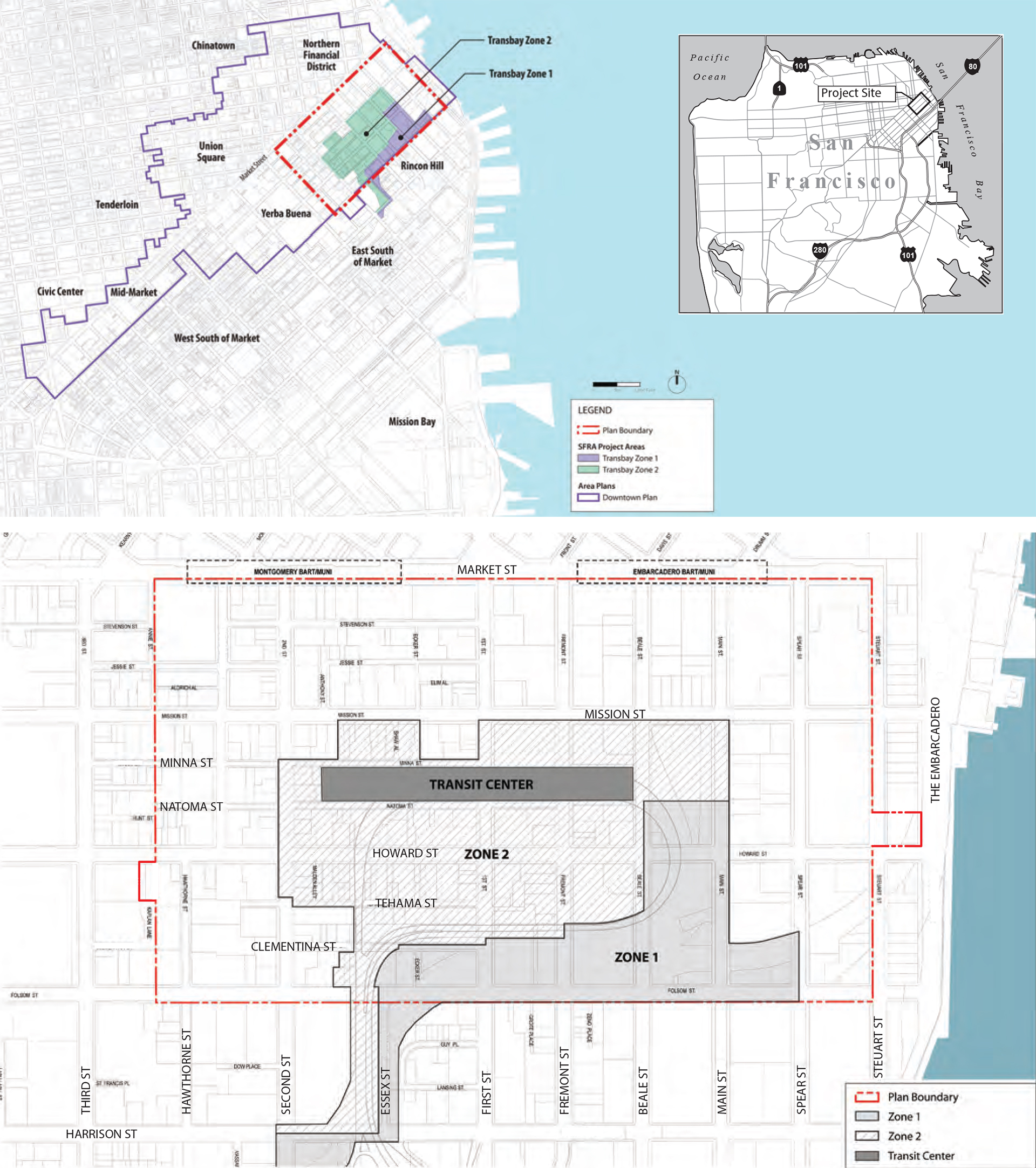
Plan Area Boundary
The Transit Center District, or Plan Area, consists of approximately 145 acres centered on the Transbay Transit Center, situated between the Northern Financial District, Rincon Hill, Yerba Buena Center and the Bay. The boundaries of the District are roughly Market Street on the north, Embarcadero on the east, Folsom Street on the south, and Hawthorne Street to the west. While these boundaries overlap with those of the Transbay Redevelopment Project Area, this Plan does not affect the adopted land use or development controls for Zone 1 of the Redevelopment Area and is consistent with the overall goals of the Transbay Redevelopment Plan.
The majority of the land within the Plan Area is privately-owned with the notable exceptions of parcels owned by the Transbay Joint Powers Authority (TJPA), of which at least two will be available for significant new development: the site of the proposed Transit Tower (in front of the Transit Center along Mission Street), and a lot (Parcel “F”) on the north side of Howard between First and Second streets formerly housed bus ramps to be rebuilt on adjacent parcels just to the west. (Additionally, Zone 1 of the Redevelopment Area, also within the Plan Area, is primarily comprised of publicly-owned parcels subject to the controls of the Redevelopment Plan as opposed to the Planning Code.)
Plan Goals
The overarching premise of the Transit Center District Plan is to continue the concentration of additional growth where it is most responsible and productive to do so—in proximity to San Francisco’s greatest concentration of public transit service. The increase in development, in turn, will provide additional revenue for the Transit Center project and for the necessary improvements and infrastructure in the District.
Increasing development around downtown San Francisco’s rich transit system and increased revenues for public projects are core goals of the Plan, but it is also critical that these policies be shaped by the values and principles of place-making that are essential to maintaining and creating what makes San Francisco a livable and unique city. The guiding principal behind the policies of the Transit Center District Plan is to balance increased density with the quality of place considerations that define the downtown and the city. With that in mind, the Plan is concerned with:
-
The livability of public spaces; ensuring sunlight, sufficient green space, accessibility, and attention to building details.
-
Scale of the built environment and the perception and comfort of the pedestrian.
-
The essential qualities and relationships of the built city at the macro level of skyline and natural setting, and the images that inspire residents and visitors everyday and connect them to this place.
-
The ground plane; a graceful means for moving from place to place, for pausing, for socializing, and for conducting business.
-
A comprehensive program of sustainability that goes beyond the basic underpinnings of land use and transportation, and includes supporting systems, such as water and power.
-
A transportation system that supports and reinforces sustainable growth and the District’s livability, one that ensures sufficient and appropriate capacity, infrastructure, and resources.
Plan Overview and Context
In 1985, the City adopted the landmark Downtown Plan, which sought to shape the downtown by shifting growth to desired locations. The plan sought to expand the job core, then concentrated north of Market Street, to south of Market Street, especially around the Transbay Terminal. The Terminal area was designated as desirable for growth for a number of reasons. First, the expansion of downtown south of Market Street would better center job growth on the major local and regional transit infrastructure along the Market Street corridor. Second, re-directing growth potential would protect important, valued downtown historic buildings from demolition. As an incentive, the Downtown Plan permitted development rights to be transferred from these buildings to the Transit Center District.
The Downtown Plan also emphasized the tangible and intangible qualities essential to keeping San Francisco a special place. The plan made broad, but well-articulated, gestures to preserve the best of the past, shape new buildings at an appropriate scale, and provide for a range of public amenities. Additionally, the plan included measures to ensure that the necessary support structure paralleled new development, through requirements and fees for open space, affordable housing, and transit, as well as a system to meter and monitor growth over time.
It has been 25 years since the adoption of the Downtown Plan and the time has come to revisit its policies and identify those that may need adjusting or strengthening. Downtown as currently envisioned by the Downtown Plan is at a point where it is largely built out, and the areas for growth are diminishing and limited. Furthermore, when the Downtown Plan was adopted, certain major pieces of infrastructure and facilities were in place or envisioned. Now, key changes have occurred and new investments are planned.
After being damaged by the 1989 Loma Prieta earthquake, the Embarcadero Freeway was torn down and the city was reconnected to its waterfront with a beautiful promenade, roadway and light rail line. This change enabled the downtown to grow southward, linking downtown to a future high-density residential neighborhood. The creation of this neighborhood was codified by the Rincon Hill Plan and the Transbay Redevelopment Plan, both adopted in 2005. Together, these plans guide the creation of a new residential neighborhood centered on Folsom Street, with a mixture of high, mid, and low-rise buildings. The high-rise elements add a new component to the skyline, creating a southern punctuation to the downtown.
During the Transbay and Rincon Hill planning processes, planners and decision-makers recognized the need to think anew about the downtown core. The Redevelopment Plan notes that the area north of the former freeway parcels along Folsom Street should be regarded as part of downtown and addressed in that context. This portion of the Redevelopment Area has been designated “Zone 2,” with jurisdiction for planning and permitting delegated back to the Planning Department.
By far, the most significant project planned for the District is the new Transbay Transit Center. Being built by the Transbay Joint Powers Authority, with construction commenced in 2010, this facility will replace the obsolete terminal with a 21st Century multi-modal transit facility meeting contemporary standards and future transit needs. The Transit Center will not only have expanded bus facilities, but will include a rail station to serve as the San Francisco terminus for Caltrain and ultimately California High Speed Rail. While the idea for improving the Transbay Terminal had existed for a number of years, this potential for building transit capacity and new public space transformation was not envisioned in 1985 when the Downtown Plan was adopted. Realizing the Transit Center and other changes demand a new, fresh look at the land use, urban form, public space, and circulation policies and assumptions for the area. Moreover, while the Transit Center project is moving ahead, additional funding is still needed for the rail portion of the project.
Downtown San Francisco in the Context of Regional Growth
The future of the Transit Center District requires consideration of its place within the context of the larger city and the region as a whole. The growth and development patterns associated with the Transit District can advance larger regional sustainability goals.
One of the defining global issues of the 21st century is environmental sustainability. Patterns of human settlement, particularly land use and transportation, are a major component of sustainable development, as much as the ways we generate our energy, grow and consume our food, and produce and consume the products that fill our lives. The inefficient patterns of population growth spreading outward from urban centers in the past 60 years (i.e. “sprawl”) have produced immeasurable dilemmas for the Bay Area, the bioregion, the state, and beyond. As a result, the region is faced with diminishing recreational space, animal habitat, and farmland; increasing levels of congestion, air and water pollution; and increasing greenhouse gases, which lead to climate change effects, such as rising sea levels, erratic and disruptive weather patterns, and decreasing habitability of our local waters and lands for indigenous fish, land animals, and plants.
The Bay Area is now intensifying efforts to grapple with the question of sustainability, particularly steps to reduce greenhouse gas emissions without stifling growth. With the passage of AB 32 (which mandates statewide reductions in greenhouse gas emissions) and SB 375 (which requires regions to adopt growth management land use plans that result in reduced greenhouse gas emissions) in the California state legislature, and similar action on climate change likely at the federal level, there is increasing momentum to encourage transit-oriented development within every jurisdiction in the region and state.
Every urban center in the region is obligated to reassess its plans and potential changes within this context. Working with the Metropolitan Transportation Commission (MTC), the Association of Bay Area Governments (ABAG) allocates targets for jobs and housing to every jurisdiction, based on regional growth projections for the next 25 years. In order to meet the targets of AB 32 and SB 375, ABAG has substantially increased growth allocations to all urban centers and transit-served locations in the region—particularly San Francisco, Oakland, and San Jose. Downtown San Francisco has existing infrastructure in place that makes it a model of successful transit-oriented, low-impact growth. Adding development capacity to the downtown is a prudent step toward furthering the goal of reducing the State and region’s development footprint.
Many of these issues of controlled growth were understood in 1985, and reflected in the Downtown Plan. The core premise of the Downtown Plan was that a compact, walkable, and transit-oriented downtown is the key precondition for the successful and sustainable growth of the city and the region. The Transit Center District Plan furthers these principles and builds on them consistent with current conditions and context.
Land Use
The Land Use section outlines the evolving nature of land uses downtown and in the Transit Center District. It sets forth policies aimed at fulfilling a vision for the District as the city’s grand center, a symbol of the region’s vitality, with a dense mix of uses, public amenities, and a 24-hour character.
Introduction and Context
Since the adoption of the Downtown Plan in 1985, much of the area has been developed and multiple economic cycles have come and gone. Major growth has transformed portions of the downtown, particularly south of Market Street, expanding the downtown southward as directed by the Downtown Plan. In 1985, Mission Street was not regarded in any way as a prime downtown location; today, Mission Street is a premier address, an expansion of the city's Financial District. With new high-density downtown residential neighborhoods planned and starting to grow on the southern edge of the downtown, Mission Street and the Transbay Transit Center are fast becoming the geographic heart and center of the downtown, which now stretches from Rincon Hill and the Bay Bridge on the south to the Transamerica Pyramid on the north. The few remaining potential development sites in downtown are primarily near the Transbay Transit Center.
Downtown Growth in the Transit Center District
Maintaining a compact, walkable central business district, one that can be walked from end to end in about 20 minutes, is a core premise of the Downtown Plan. Compactness, particularly in relation to public transit, was recognized as one of the district’s chief assets. The Downtown Plan envisioned the area just south of Market Street around the Transbay Terminal not just as the primary growth area of the downtown, but as its hub.
A quarter of a century ago, during the preparation of the Downtown Plan, few downtown functions existed south of Market Street. The city was experiencing a major demand for office space and unless new policies were enacted, growth would continue to displace older important buildings in the business core north of Market. The Downtown Plan proposed and the City adopted new Planning Code provisions that landmarked dozens of important buildings and shifted office development to a special district with the city’s tallest height limits (at 550 feet) around the Transbay Terminal. Zoning was also structured to enable unused development rights from designated historic buildings throughout the downtown to be transferred to this district.
In recent years, development has occurred in the Transit Center District, and the goals and controls enacted in the Downtown Plan are being realized. The Transit Center District Plan is intended to build on the goals and principles of the Downtown Plan, and to continue to realize development potential and public investment in the Transit Center District.
Regional Environmental Sustainability and Downtown San Francisco
How people commute to work has dramatic implications for the region’s overall sustainability. More driving leads to more greenhouse gas emissions, lower air and water quality, more congestion on regional roads, and negative impacts on social equity and access to jobs (as jobs located away from public transportation are difficult to reach for lower income and transit-dependent people). Compared to other locations in the region, downtown San Francisco has far and away the highest share of workers commuting by means other than auto. Over 75 percent of all workers in the core part of the Financial District use transit to get to work, with only 17 percent driving or carpooling. Once a job is located outside of downtown, even within San Francisco, the percentage of transit users drops by half and the auto use rises equivalently. In downtown Oakland area, transit use is lower still. Outside of these major downtowns, the percentage of workers that do not drive to work is minuscule. Increasing the development capacity in the Transit Center District, as opposed to any other locality in the region (or city), will go further to support both local and regional goals to reduce greenhouse gas emissions and reduce other environmental impacts without major additional regional transit investment beyond those already planned.
While concentrating both jobs and housing (and other uses) near major transit centers reduces auto travel, research has consistently shown a notably stronger correlation between auto travel and the proximity of jobs to transit than housing to transit. That is, workers, in determining whether to take transit or drive to work, are more sensitive to distance from major transit on the job end of the commute trip than on the home end. Research has also shown the threshold for job proximity to transit is not more than ½-mile from regional transit, whereas for housing it is one mile or more. This suggests that to maximize regional transit use and achieve the lowest overall auto travel, land immediately proximate to major regional transit (e.g. rail stations like BART or Caltrain) should be oriented more toward high-density jobs, with areas ringing these cores oriented more to high-density housing. Both areas should be mixed-use and pedestrian-oriented with a rich variety of supporting services (such as retail and community facilities), in order to create a vibrant and active district for residents, employees, and visitors. Most importantly, this research helps to confirm the land use mix envisioned in the Plan Area.
Objectives and Policies
The following objectives and policies are intended to achieve the vision set out for the Transit Center District as a high-density, vibrant employment center, with building heights, densities, FAR, and an engaging public realm appropriate to its place in the city.
OBJECTIVE 1.1
MAINTAIN DOWNTOWN SAN FRANCISCO AS THE REGION’S PREMIER LOCATION FOR TRANSIT-ORIENTED JOB GROWTH WITHIN THE BAY AREA.
OBJECTIVE 1.2
REINFORCE THE ROLE OF DOWNTOWN WITHIN THE CITY AS ITS MAJOR JOB CENTER BY PROTECTING AND ENHANCING THE CENTRAL DISTRICT’S REMAINING CAPACITY, PRINCIPALLY FOR EMPLOYMENT GROWTH.
OBJECTIVE 1.3
CONTINUE TO FOSTER A MIX OF LAND USES TO REINFORCE THE 24-HOUR CHARACTER OF THE AREA.
POLICY 1.1
Increase the overall capacity of the Transit Center District for additional growth.
For the core of the downtown business district where building heights are the tallest, overall development density is controlled primarily through FAR, and secondly through height and bulk limitations. For areas with the tallest height limits, the maximum physical envelope allowed or desired are often not attainable without acquiring and combining multiple contiguous parcels, which is often not possible or desirable. This condition leads to buildings that are not fully maximized in development intensity in the core area where it is most appropriate. There is currently a maximum cap of 18:1 FAR in the C-3-O and C-3-O (SD) districts. Rezoning the entire Plan area to C-3-O(SD) and eliminating the upper FAR limit will enable buildings to achieve the densities and heights envisioned in the Plan, with some reaching an FAR of over 30:1. As a result of lifting the FAR cap, controls for the physical envelope of the buildings will regulate the development density of the District. This step, however, will require even more thought on physical design quality and building envelope to ensure the maintenance of a livable and attractive downtown. New guidelines for design quality and building scale that build on existing controls and design guidelines are included in the Urban Form section of this Plan.
POLICY 1.2
Revise height and bulk limits in the Plan Area consistent with other Plan objectives and considerations.
While acknowledging the Plan’s premise that the overall development capacity of the District should be increased, height and bulk limits must be also shaped by considerations for urban form, key public views, street level livability, shadows on key public spaces, wind impacts, historic resources, and other factors. Height and bulk limits are discussed in more detail in the Urban Form section of the Plan.
POLICY 1.3
Encourage and permit non-residential uses on major opportunity sites.
In view of the limited number of sizable development sites in the District, which represent the bulk of the remaining office capacity in the downtown core, it is essential to allow major development sites to include a sizable commercial component.
Preserving office and job growth capacity is a major consideration, but so too is ensuring a mix of uses to help the area achieve a more 24-hour character. A mix of uses is generally desirable for very large projects. Additionally, the Plan recognizes that small lots are often not large enough to be developed with efficient office buildings, and some very large buildings contemplated in the Plan (i.e. taller than 600 feet) may be too large from a risk and market absorption standpoint to be devoted to a single use.
POLICY 1.4
Prevent long-term under-building in the area by requiring minimum building intensities for new development on major sites.
Major existing and planned investments in regional and local transit infrastructure and a limited capacity for added development make it unwise to permit new development to substantially under-build any of the few remaining major development sites in downtown. Moreover, under-building yields substantially lower revenues than necessary to help fund the Transit Center, affordable housing, streetscape improvements, and other area infrastructure.
POLICY 1.5
Consider the complexity and size of projects in establishing the duration for entitlements for large development projects.
Many development projects in the Plan Area are, by their very nature, large and complex. In the best of circumstances, it can take projects a year or two to finalize construction financing, complete the necessary drawings and documents, and complete final reviews with the necessary City agencies prior to actually commencing construction. Further, the fluctuations of local and wider economic conditions can slow down the completion of an approved project despite the best efforts of project sponsors to construct approved and desirable projects. Because of the size and complexity of many of the large projects in the Plan Area, these factors are magnified to necessitate longer lead times to reasonably realize these projects. Currently, planning entitlements are typically valid for three years (but some for as little as 18 months) prior to mandatory discretionary hearings to consider extensions. The City should evaluate all of the pertinent entitlement durations that may affect a project and consider adopting a uniform longer time-frame for entitlement validity, such as five years.
OBJECTIVE 1.4
ENSURE THE DISTRICT MAINTAINS AREAS THAT CONTAIN CONCENTRATIONS OF GROUND-LEVEL PUBLIC-SERVING RETAIL AND CONVENIENCE USES FOR WORKERS AND VISITORS.
OBJECTIVE 1.5
ACTIVATE ALLEYS AND MID-BLOCK PEDESTRIAN WALKWAYS WITH ACTIVE USES IN ADJACENT BUILDINGS TO MAKE THESE SPACES ATTRACTIVE AND ENJOYABLE.
POLICY 1.6
Designate certain select street frontages as active retail areas and limit non-retail commercial uses, such as office lobbies, real estate offices, brokerages, and medical offices, from dominating the street level spaces.
Establishing a vibrant public realm is a critical element of achieving the goals of the Transit District, such as supporting an active employment center, encouraging transit use, and creating a walkable and pedestrian-friendly street environment. While all streets and alleys should be pedestrian-oriented and feature active uses lining the ground floors, key streets and alleys to ensure active retail uses include 2nd Street, Natoma Street, and Ecker Street.
Urban Form
Urban form relates to the physical character of an area and the relationship of people and the landscape to the built environment. In the Transit Center District Plan Area, urban form is especially important as the intensity and height of buildings planned for the area greatly affects the character and quality of the city, and our experience of it at two levels: at both the cityscape level and at the ground level. Because of this, urban form within the Plan Area is considered at several scales, including building heights and their effect on the skyline and views, tower design, streetwall design, and the experience at the pedestrian level.
This section addresses the balance between maximizing development intensity in the Plan area to take advantage of proximity to good transit access and ensuring that the core objectives of urban form and livability are achieved— creating and maintaining a sense of place, protecting public views, and ensuring a pleasant and welcoming pedestrian environment.
The City adopted the Urban Design Element of the General Plan in 1972 and the Downtown Plan in 1985. These plans set out the policies that have achieved the characteristics of downtown San Francisco we enjoy today: a compact, human-scaled, walkable and dynamic urban center and a dramatic concentrated skyline set against the natural backdrop of the city’s hills. This section builds on the core principles of city form established in these two plans. It presents key objectives and policies for directing new development in a manner that enhances the overall cityscape and builds upon established and planned transit assets downtown.
Building Height and Skyline
San Francisco is renowned for its physical beauty and unique sense of place. These qualities are defined by buildings and streets laid upon hills and valleys, the San Francisco Bay and Pacific Ocean, and signature landmarks poised at picturesque locations. This stunning assemblage—the rise and fall of hills, the backdrop of a downtown cityscape against the water and hills across the Bay, the iconic pairing of the Bay Bridge with the skyline—are enjoyed by residents and visitors viewing the city from its hills, streets, public spaces, and surrounding vantages. The city’s urban form at this scale is an essential characteristic of San Francisco’s identity. The city’s urban form:
-
Orients us and provides a sense of direction;
-
Imprints in our minds the physical relationship of one place to another, through features of topography, landscape, access, activity, and the built environment;
-
Distinguishes one area from another; and
-
Grounds us, providing reference points and reminding us of where we are.
When changes to the cityscape are considered, the goal is to build on and reinforce existing patterns and qualities of place that provide the city with its unique identity and character. The natural topography of the city is augmented by the man-made topography of its skyline, such as the concentrations of large buildings within downtown. Changes to the skyline, such as significant changes in allowable building heights, must be considered as if reshaping major elements of the city’s natural topography of hills and valleys, for this is the scale of change to the visual landscape that they represent. The undifferentiated spread of tall buildings without appropriate transitions, or without deference to the larger patterns, iconic and irreplaceable relationships, or to key views of defining elements of the area’s landscape, can diminish and obscure the city’s coherence and the collective connection of people to their surroundings.
The critical factors in the urban form at a larger scale are building height (and bulk) and the placement and orientation of tall buildings. While a building design may be gracious, well-articulated, and artistic in its own right, its placement, scale and orientation relative to the overall cityscape is equally, if not more, important. A building design and scale that may be appropriate in one specific location may not be appropriate if sited even one block away.
In addition to affecting the quality of place at the cityscape level, the size and placement of buildings significantly influence the quality of the city at the ground level. One specific effect of building height and location at ground level is sunlight access on streets and public spaces. San Franciscans have long expressed and continue to reinforce the importance of maintaining sunlight on streets and public spaces. As the Downtown Plan states, “As a forest becomes denser, it becomes more difficult to find a sunlit meadow. Similarly, in San Francisco's downtown, sunshine and wind protection, which are essential to the personal comfort of open space users, become of prime importance in the planning for downtown open space.” This is not to say that all potential shading of all public spaces should be avoided at all costs. What is of most concern is the shading of heavily-used open spaces during key usage times of the day and in key locations. Consistent with the procedures and standards adopted as part of the implementation of sunlight protection regulations, primarily Section 295 (“Prop K”) created by the voters, decision makers must weigh the Plan’s overarching public objectives against potential impacts. The urban form proposals of this Plan, particularly building height, are tailored where possible with an eye to this key ingredient of livability (i.e. without compromising the core Plan objectives for land use and the larger urban form).
The following objectives and policies address building height and skyline within the Plan area, with attention focused on creating a high quality urban form, at both the cityscape scale and on the ground.
OBJECTIVE 2.1
MAXIMIZE BUILDING ENVELOPE AND DENSITY IN THE PLAN AREA WITHIN THE BOUNDS OF URBAN FORM AND LIVABILITY OBJECTIVES OF THE SAN FRANCISCO GENERAL PLAN.
OBJECTIVE 2.2
CREATE AN ELEGANT DOWNTOWN SKYLINE, BUILDING ON EXISTING POLICY TO CRAFT A DISTINCT DOWNTOWN “HILL” FORM, WITH ITS APEX AT THE TRANSIT CENTER, AND TAPERING IN ALL DIRECTIONS.
OBJECTIVE 2.3
FORM THE DOWNTOWN SKYLINE TO EMPHASIZE THE TRANSIT CENTER AS THE CENTER OF DOWNTOWN, REINFORCING THE PRIMACY OF PUBLIC TRANSIT IN ORGANIZING THE CITY'S DEVELOPMENT PATTERN, AND RECOGNIZING THE LOCATION'S IMPORTANCE IN LOCAL AND REGIONAL ACCESSIBILITY, ACTIVITY, AND DENSITY.
OBJECTIVE 2.4
PROVIDE DISTINCT TRANSITIONS TO ADJACENT NEIGHBORHOODS AND TO TOPOGRAPHIC AND MAN-MADE FEATURES OF THE CITYSCAPE TO ENSURE THE SKYLINE ENHANCES, AND DOES NOT DETRACT FROM, IMPORTANT PUBLIC VIEWS THROUGHOUT THE CITY AND REGION.
OBJECTIVE 2.5
BALANCE CONSIDERATION OF SHADOW IMPACTS ON KEY PUBLIC OPEN SPACES WITH OTHER MAJOR GOALS AND OBJECTIVES OF THE PLAN, AND IF POSSIBLE, AVOID SHADING KEY PUBLIC SPACES DURING PRIME USAGE TIMES.
POLICY 2.1
Establish the Transit Tower as the “crown” of the downtown core—its tallest and most prominent building—at an enclosed height of 1,000 feet.
As the geographic epicenter of downtown, as well as the front door of the Transbay Transit Center, the Transit Tower should be the tallest building on the city’s skyline. The Tower represents the City’s commitment to focusing growth around a sustainable transportation hub, as well as the apex of the downtown skyline. Additionally, the sheer prominence of this building will be a substantial benefit to the Transit Center itself, as 100 percent of the Transbay Terminal revenue from the sale or lease of the publicly-owned land for the Transit Tower development will be used for the funding of the Transit Center program. Based on visual simulations of urban form alternatives, a Transit Tower height of 1,000 to 1,200 feet (to the tip of the building’s tallest element) is appropriate and desirable.
The creation of a new crown to the skyline adjacent to the Transit Center is an important objective of the Plan. If the Transit Tower is built ultimately to a height of less than 900 feet or otherwise reasonably judged after a period of time unlikely to be built, the Planning Commission and Board of Supervisors should consider rezoning one of the key sites near the corner of 1st and Mission Streets to a height of 1,000 feet.
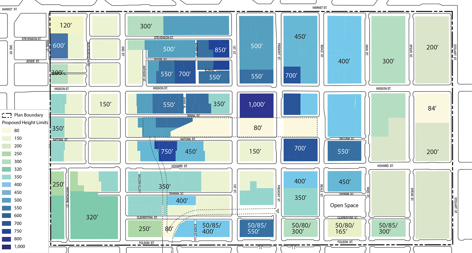
FIGURE 2 - Proposed Height Limits
(Note: Height limits shown at 600 feet or taller are intended to indicate total building height as described further in Policy 2.7 and are not intended to allow for the ten percent tower height extensions allowed for the “S” bulk district. Height limits shown at lower than 600 feet are intended to remain in the “S” bulk district.)
POLICY 2.2
Create a light, transparent sculptural element to terminate the Transit Tower to enhance skyline expression without casting significant shadows. This vertical element may extend above the 1,000 foot height limit.
To ensure an elegant and unique sculptural termination to the top of the Transit Tower, an un-enclosed sculptural element that is consistent with the building's architecture and is set in a way that addresses shadow concerns is strongly encouraged.
POLICY 2.3
Create a balanced skyline by permitting a limited number of tall buildings to rise above the dense cluster that forms the downtown core, stepping down from the Transit Tower in significant height increments.
In order to create a skyline in all directions to enhance the downtown’s topographic “hill” form with graceful transitions in all directions, a small number of buildings should rise above a height of 600 feet—the downtown’s current maximum height limit—but at heights lower than the Transit Tower site. The number of these buildings greater than 600 feet in height should be limited and carefully sited to maintain sky visibility between them from key public vantage points and to prevent these buildings from visually merging into a single wide mass of great height.
One building of up to 850 feet in height is desirable between Market and Mission Streets, just west of First Street, sufficiently distanced from the Transit Tower, on the west side of First Street, north of Elim Alley. Should a building taller than 700 feet not be built in this zone within a sufficient amount of time, such as ten years, or otherwise reasonably judged unlikely to come to fruition, the City should consider reclassifying the 700-foot zone on the north side of Mission Street just west of Ecker Street to enable a building up to 850 feet to be constructed at that site.
Height transitions of at least 150 feet (e.g. 1000 to 850, 850 to 700, 700 to 550) are essential between major height tiers in order to create graceful and distinct transitions between buildings of such scale in this compact area. A more significant transition, however, is necessary in the southern portion of the District, where prevailing building heights in the districts immediately adjacent are lower. In this area, height limits should more quickly transition to 350 feet and lower.
POLICY 2.4
Transition heights downward from Mission Street to Folsom Street and maintain a lower “saddle” to clearly distinguish the downtown form from the Rincon Hill form and to maintain views between the city’s central hills and the Bay Bridge.
POLICY 2.5
Transition heights down to adjacent areas, with particularly attention on the transitions to the southwest and west in the lower scale South of Market areas and to the waterfront to the east.
The intent of the urban form changes introduced by the Rincon Hill Plan was to separate the Hill’s form from the downtown skyline. For all of the reasons discussed earlier in this section, maintaining a sense of place and orientation by distinguishing neighborhoods and districts on the skyline is important. The building heights of Rincon Hill and areas to the north were crafted to maintain a lower point, or “saddle” in the skyline between Howard Street and the north side of Folsom Street. This lower stretch on the skyline between the downtown core and Rincon Hill also provides important east-west views from the hills in the center of the city (e.g. Corona Heights, Twin Peaks, Upper Market) to the East Bay hills, the Bay Bridge, the Bay, and vice versa. This section of the skyline should achieve a height no taller than 400 feet. Equally important to stepping down buildings in the north-south direction, structures should also transition downward to adjacent lower scale neighborhoods and to the waterfront. Building heights should taper down to 250 feet and lower along the Second Street corridor to the southwest.
POLICY 2.6
Ensure a minimum height requirement for the Transit Tower site, as well as other adjacent sites zoned for a height limit of 750 feet or greater.
The ultimate height of the occupied portion of the building proposed for the Transit Tower (and other buildings) will be affected largely by the market. To achieve the urban form goals of the Plan, it is critical that this building be the crown of the skyline. If, for whatever reason, the Transit Tower is proposed for an occupied height lower than the maximum height allowed, the building should include an architectural feature that extends the effective height of the building in some form to a height of at least 950 feet.
POLICY 2.7
Establish controls for building elements extending above maximum height limits to incorporate design considerations and reduce shadow impacts.
The typical height limit rules that apply to buildings in the C-3 and in the S bulk districts which allow tower extensions and that govern architectural elements at the tops of buildings should not apply to buildings taller than 650 feet or where height limits are greater than 550 feet. Instead, specific rules should be crafted to apply to such tall buildings to reflect their central and iconic positions on the skyline in order to enhance their appearance while minimizing potential visual and shadow impacts.
Building Design: Tower Zone
The Transit Center District will be home to several of the tallest buildings in San Francisco. Because these buildings affect the street environment, access to sun and sky, and the skyline, the massing and design of towers is critical to achieving the overall urban form goals for the Plan area. With this in mind, the following objectives and policies address the massing and scale of tall buildings within the District.
OBJECTIVE 2.6
PROVIDE FLEXIBILITY AND SUFFICIENT ALLOWANCE FOR THE STRUCTURAL CORE OF TALL BUILDINGS (TALLER THAN 600 FEET), WHILE ENSURING THAT THE BUILDINGS MAINTAIN ELEGANT AND SLENDER PROPORTIONS AND PROFILE.
OBJECTIVE 2.7
ENSURE ARTICULATION AND REDUCTION TO THE MASS OF THE UPPER PORTIONS AND TOPS OF TOWERS IN ORDER TO CREATE VISUAL INTEREST IN THE SKYLINE AND HELP MAINTAIN VIEWS.
OBJECTIVE 2.8
MAINTAIN SEPARATION BETWEEN TALL BUILDINGS TO PERMIT AIR AND LIGHT TO REACH THE STREET, AS WELL AS TO HELP REDUCE ‘URBAN CANYON’ EFFECTS.
Do not limit the floorplate or dimensions of the lower tower for buildings taller than 550 feet.
POLICY 2.9
Require a minimum 25 percent reduction in the average floorplate and average diagonal dimension for the upper tower as related to the lower tower.
For the purposes of this Plan, towers are divided vertically into two main components: the Lower Tower (generally defined as the lower 2/3 of the tower) and Upper Tower (the upper 1/3 of the tower). For buildings taller than 650 feet, there should be no bulk controls for the Lower Tower. However, adherence to tower separation rules is critical and exceptions to them must be limited. To reduce bulk at the highest levels, a 25 percent floorplate reduction and 13 percent average diagonal reduction is required for the Upper Tower portion of tall buildings.
POLICY 2.10
Maintain current tower separation rules for buildings up to 550 feet in height, extend these requirements for buildings taller than 550 feet, and define limited exceptions to these requirements to account for unique circumstances, including adjacency to the Transit Center and to historic structures.
Building Design: Streetwall and Pedestrian Zone
The character of a district is largely defined by the scale of the roadway, sidewalks, and adjoining building frontages. Collectively, these shape the pedestrian experience by creating a sense of enclosure, often called an "urban room." The Transit District will contain many of the city's tallest buildings and buildout of the District will entail replacement of many smaller buildings that now provide a humane scale. Without moderation and articulation of the lower portions of tall buildings, the result could lack pedestrian references that create a comfortable experience at the ground level. Therefore, it is particularly critical that buildings be designed in a thoughtful manner, taking into consideration the street scale and pedestrian interest in the massing of tall buildings, not simply be designed as architectural gestures of the skyline. In addition, the ground floors must foster a lively and attractive pedestrian experience. In guiding building design in the Plan Area, the following policies address two main building zones:
Streetwall Zone. The height of the streetwall, generally its relation to the street width, is a defining characteristic of a neighborhood’s scale. Within the Transit Center District, the streetwall is defined as that part of the building above the pedestrian zone and extending to a height of 55 to 110 feet (depending on the context).
Pedestrian Zone. Pedestrians are most aware of the first two to three stories at the ground, or what is within their immediate view. These policies focus on the character of the street and how buildings meet the ground. The pedestrian zone is defined as the first 20–25 feet of a building.
Streetwall Zone
OBJECTIVE 2.9
PROVIDE BUILDING ARTICULATION ABOVE A BUILDING BASE TO MAINTAIN OR CREATE A DISTINCTIVE STREETWALL COMPATIBLE WITH THE STREET’S WIDTH AND CHARACTER.
OBJECTIVE 2.7
MAINTAIN APPROPRIATE CHARACTER-DEFINING BUILDING SCALE IN THE HISTORIC DISTRICT.
POLICY 2.11
Ensure that buildings taller than 150 feet in height establish a distinct base element to define the street realm at a comfortable height of not more than 1.25 times the width of the street.
Buildings with sheer facades rising up straight from the ground without a horizontal break at the streetwall height create a vertiginous and inhuman scale, particularly when grouped without intervening lower scale buildings. Unlike the Financial District area north of Market Street where numerous historic buildings of moderate scale remain interspersed between taller buildings, the core parts of the Transit Center District (such as along Mission Street) where likely development sites exist have only a few significant older buildings of modest scale (i.e. 50 to 100 feet in height). The Downtown Plan contains a policy to require a horizontal element (e.g. a belt course) on the façade in a manner that suggests a human-scaled building base, but this architectural feature alone is insufficient. Towers that incorporate upper story setbacks to define a distinctive base element or that distinctly taper away from the streetwall above the base height help to create a comfortable pedestrian environment, one that is more scaled to the human perspective at the street level. For the Transit Center District, a streetwall height of 55 to 110 feet defines a comfortable “urban room,” based on a prevailing street width of 82.5 feet. Where project sites are large enough to incorporate multiple buildings along the street face, including both tall towers and lower scale buildings of 150 feet in height or less, the towers themselves may not necessarily need to feature setbacks. However, where projects consist of a single tall building at the street face, even if accompanied by an adjacent open plaza, such towers should meet the articulation requirements described above. At least 60 percent of the building frontages on each block face should feature a distinct base that contributes to creating the urban room.
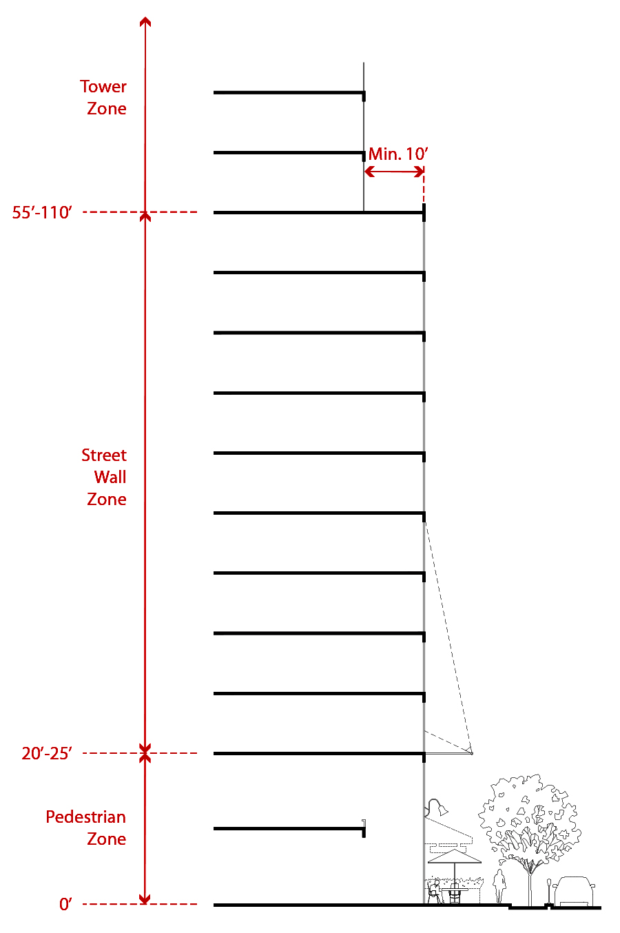
FIGURE 3 - Streetwall and Pedestrian Zone
POLICY 2.12
Where construction of the downtown rail extension must unavoidably demolish buildings, reduce impacts on the District’s character by facilitating appropriate re-use of these parcels.
The underground downtown rail extension is planned under Second Street curving eastward into the basement of the Transit Center. While the Second Street construction can be executed within the right-of-way, the necessary curvature alignment and widening of the tracks into the Transit Center necessitate the full or partial acquisition of several private parcels at both the northeast and southeast corners of Second and Howard streets, including the demolition of several buildings. It is important to ensure a positive re-use of these sites so that the district is not left with awkward or minimally-usable parcels. Because of the unique situations caused by the train’s alignment affecting both sides of Howard Street, the Plan proposes the following distinct responses:
Northeast Corner: The extent of the below-grade alignment and complexity of the track and station infrastructure challenges the feasibility of significant development at this corner. As a result, the best possible use of these parcels is the creation of a new public open space that facilitates pedestrian flow to the Transit Center and provides both a needed additional ground level open space and an opportunity for a major public vertical access to the rooftop Transit Center park. The design of the plaza should also incorporate architectural elements at the street edge that connect the plaza to the fabric of the historic district. The Public Realm section provides more detail on this concept.
Southeast Corner: The eastern edge of the underground track alignment slices diagonally across the three parcels north of Tehama Street and west of Malden Alley, with little possibility of constructing a building with foundations or columns immediately above the tracks. The remaining developable portion of the parcels east of the tracks totals approximately 9,000 square feet, though in a somewhat awkward wedge configuration. Given the potential for a plaza at the more appropriate northeast corner of this intersection adjacent to the Transit Center, a new building should be encouraged on this site to maintain the physical continuity of the historic district along Second and Howard streets. Though it may not possible to construct building foundations above the rail tunnel on this site, a new building here should strive to create a prominent corner presence at Second and Howard.
To make a new building more feasible given the shape and size of the site that remains after the Downtown Rail Extension right-of-way needs are met, the City should consider vacating Malden alley in order to permit a merger with the affected properties along Second Street. The General Plan includes policies (Urban Design Element Policies 2.8–2.10) discouraging the vacation of public-rights-of-way except under unique and extraordinary circumstances in which the demonstrable public benefit of a proposed project requiring the vacation substantially outweighs the loss in public value (both current and potential) of maintaining the right-of-way in public ownership. In this unique circumstance, vacating Malden could aid in the positive transition of this block in light of the rail alignment. Consequently, at an appropriate point following completion of arrangements with the TJPA to secure the necessary property for the rail alignment and submittal of a building proposal, vacation of Malden should be considered consistent with the General Plan vacation policies along with demolition of the subject buildings along Second Street. If the extent of the rail alignment necessitates taking more of the parcels along 2nd Street than is currently planned, a major development would be unlikely on these sites and the rationale for vacating Malden Alley may not be justifiable.
OBJECTIVE 2.11
PURSUE BUILDING SETBACKS TO AUGMENT A SIDEWALK WIDENING PROGRAM ON STREET FRONTAGES WHERE SIGNIFICANT CONTIGUOUS STRETCHES OF PARCELS ARE LIKELY TO BE REDEVELOPED.
In some areas within the Transit Center District, the program for widening sidewalks can be augmented by requiring building setbacks. Such treatment, however, is only appropriate where there are contiguous stretches of anticipated new development, such as those listed and in those situations where the result would not create a “sawtooth” pattern of building frontages at the sidewalk. When utilized, building setbacks must be designed as a seamless extension of the sidewalk.
POLICY 2.13
As appropriate on a case-by-case basis, require new buildings located at major street corners (outside of the Conservation District) in the Plan Area to modestly chamfer the corner of the building at the ground level (if the building is otherwise built out to the property line) in order to provide additional pedestrian space at busy corners.
POLICY 2.14
Require building setbacks for new buildings to expand the roadway where necessary to accommodate needed transit, bicycle and pedestrian facilities.
A minimum setback of at least 12.5 feet should be required on the following frontage:
- South side of Mission Street between First and Fremont streets (Transit Tower).
This is necessary to accommodate new roadway configuration for Mission Street on this block that includes a transit boarding island while still maintaining the necessary sidewalk width (e.g. 20’) in front of the tallest building in the City and the busy Transit Center hub.
Consider requiring a building setback of up to ten feet on the following frontages if development proceeds such that a desirable pattern of buildings would result:
- North side of Mission Street between First and Second streets
- North side of Howard Street between First and Second streets
- West side of First Street between Market and Mission streets
Pedestrian Zone
Buildings in the Transit Center District should be designed at where they meet the ground, in such a way that reinforces the human scale. Ground floor uses and building features such as entries, building materials, canopies and awnings, display windows, and lighting, all contribute to conditions ideal for attracting pedestrian activity. To that end, the following policies apply to the pedestrian zone of all buildings within the District.
OBJECTIVE 2.12
ENSURE THAT DEVELOPMENT IS PEDESTRIAN-ORIENTED, FOSTERING A VITAL AND ACTIVE STREET LIFE.
OBJECTIVE 2.13
ENACT URBAN DESIGN CONTROLS TO ENSURE THAT THE GROUND-LEVEL INTERFACE OF BUILDINGS IS ACTIVE AND ENGAGING FOR PEDESTRIANS, IN ADDITION TO PROVIDING ADEQUATE SUPPORTING RETAIL AND PUBLIC SERVICES FOR THE DISTRICT.
OBJECTIVE 2.14
ENCOURAGE TALL AND SPACIOUS GROUND FLOOR SPACES.
OBJECTIVE 2.15
ENCOURAGE ARTICULATION OF THE BUILDING FAÇADE TO HELP DEFINE THE PEDESTRIAN REALM.
OBJECTIVE 2.16
MINIMIZE AND PROHIBIT BLANK WALLS AND ACCESS TO OFF-STREET PARKING AND LOADING AT THE GROUND FLOOR ON PRIMARY STREETS TO HELP PRESERVE A SAFE AND ACTIVE PEDESTRIAN ENVIRONMENT.
POLICY 2.15
Establish a pedestrian zone below a building height of 20 to 25 feet through the use of façade treatments, such as building projections, changes in materials, setbacks, or other such architectural articulation.
Combined with upper level setbacks to define the streetwall, emphasizing the ground floor of a building can help create a more interesting and comfortable streetscape and pedestrian environment.
POLICY 2.16
Require major entrances, corners of buildings, and street corners to be clearly articulated within the building’s streetwall.
POLICY 2.17
Allow overhead horizontal projections of a decorative character to be deeper than one foot at all levels of a building on major streets.
POLICY 2.18
Limit the street frontage of lobbies and require the remaining frontage to be occupied with public-oriented uses, including commercial uses and public open space.
Expansive lobby frontages do not activate the street or contribute to an engaging pedestrian experience and can negatively dampen and discourage the life and character of the district. Frontages where lobbies are minimized in width (but prominent) at the street face can be lined with active spaces, such as commercial uses and public space, creating an engaging pedestrian experience. Lobbies should be limited to 40 feet in width or 25 percent of the street frontage of the building, whichever is larger.
POLICY 2.19
Discourage the use of arcades along street frontages, particularly in lieu of setting buildings back.
Arcades are generally not an appropriate design solution within the Transit Center District, as they can deaden the sidewalk environment by separating a building’s ground floor from the street by a wall of columns. Additionally, as development sites are generally not contiguous along an entire block and are interspersed with existing buildings, arcades remain as truncated non-continuous paths of travel and so are generally avoided by pedestrians whose destinations are other than the immediate building. In addition, San Francisco’s cool, temperate climate often results in empty, little-used arcades in Downtown which, because they are carved out of the building face at the ground level, do not receive direct sunlight. In climates that are warmer or wetter than San Francisco’s, arcades can be a more practical and valuable addition to the urban environment.
POLICY 2.20
Require transparency of ground-level facades (containing non-residential uses) that face public spaces.
Opaque window treatments and the placement of mechanical building features (even if camouflaged) on the façade within the pedestrian zone effectively act as blank walls that have a deadening presence along the street. By encouraging maximum ground floor transparency, this policy aims to increase the liveliness of the pedestrian realm.
POLICY 2.21
Limit the width of the individual commercial frontages on 2nd Street to maintain a dense diversity of active uses.
Second Street is the retail center of the District, characterized by many small shops and services lining the sidewalks. This pattern enables people to find a wide variety of stores and services meeting their needs and to stroll along the sidewalks browsing for restaurants and services that fit their needs. This diversity of small uses ensures a lively and vibrant district. It is important to ensure the continuance of this pattern. Ground floor spaces must be articulated into storefronts with multiple entryways. Larger floor plate uses should be wrapped by other commercial spaces such that no more than 75 linear feet of one street frontage is occupied by a single commercial space. All façades should have multiple entrances and be highly transparent.
POLICY 2.22
Prohibit access to off-street parking and loading on key street frontages. Whenever possible, all loading areas should be accessed from alleys.
Maintaining the continuity of the pedestrian environment is paramount in this busy district, as is ensuring efficient movement of transit. In order to promote active street frontages and prevent vehicular conflict with sidewalk activity and transit movement, access to off-street parking and loading should be prohibited or restricted on key streets. Please see Policy 3.9 in the Public Realm section for more detail.
Building Design: Materials
The smart use of building materials can contribute greatly to the livability and sustainability of a place. The Downtown Plan addresses this notion by stressing the importance of using consistent building materials to create a visually interesting and harmonious building pattern. This Plan builds on this by encouraging the treatment of wall surfaces, such as with plants and light coloring, to further the District’s urban design and sustainability goals.
OBJECTIVE 2.17
PROMOTE A HIGH LEVEL OF QUALITY OF DESIGN AND EXECUTION, AND ENHANCE THE DESIGN AND MATERIAL QUALITY OF THE NEIGHBORING ARCHITECTURE.
POLICY 2.23
Assure that new buildings contribute to the visual unity of the city.
For the most part, buildings in San Francisco are light in tone and harmonize to form an elegant and unified cityscape. The overall effect, particularly under certain light conditions, is that of a white city laid over the hills, contrasted against the darker colors of the Bay and the vegetated open spaces and hilltops.
POLICY 2.24
Maximize daylight on streets and open spaces and reduce heat-island effect, by using materials with high light reflectance, without producing glare.
POLICY 2.25
Encourage the use of green, or “living,” walls as part of a building design in order to reduce solar heat gain as well as to add interest and lushness to the pedestrian realm.
Public Realm
The public realm is the shared space of a city—its streets, alleys, sidewalks, parks, and plazas. It is through these spaces that we experience a city, whether it is walking to work, shopping, or having lunch in a sunny plaza. A high quality public realm is fundamental in our perception of what makes a place special. Sufficient sidewalk widths and open spaces, along with streetscape elements, such as lighting, street furniture, and plantings, all play a big role in the character, comfort, and identity of place.
San Francisco’s Transit Center District is poised to become the heart of the new downtown, and with that comes the responsibility of creating an inviting, lively public realm that not only accommodates more people, but also creates a wonderful place, one that showcases the importance of this part of the city. To reach this goal, the Plan Area, which today is rather bleak and dominated by heavy traffic, will need to be significantly transformed. Most of the streets are designed for cars traveling to and from the Bay Bridge and regional highways, and as a result, the street environment is unattractive, with long blocks, few pedestrian amenities, and poor sidewalk conditions. In addition, open space in the area is comprised of small, dispersed, privately-managed spaces on individual sites. While there are a handful of major parks nearby, such as Yerba Buena Gardens and Rincon Park, the Plan area itself lacks any significant public open space.
Within the next 10 to 20 years, the Transit Center District will see exponential increases in pedestrian volumes, making it one of the busiest areas, if not the busiest, in downtown. Two separate factors will substantially contribute to the increased pedestrian volume—land use intensification and the Transbay Transit Center itself. Adding nine million square feet of building space to these concentrated blocks will result in a density greater than that of the Financial District to the north. Furthermore, the Transit Center will attract great volumes of train and bus users throughout the day, particularly during peak hours. The downtown extension of Caltrain and the future California High Speed Rail, each running multiple trains per hour in the peak, and with capacities approaching or exceeding 1,000 passengers per train, will add thousands of people to sidewalks, corners, and crosswalks, in a downtown neighborhood already experiencing new development and growth.
To fulfill the vision of an unsurpassed pedestrian-friendly place that supports the circulation and social needs of the District, the Plan proposes substantial changes in the design and allocation of the limited right-of-way space. These necessary changes include widening sidewalks (which can largely be achieved only by shifting allocation of roadway space from autos), adding mid-block crossings at key locations, and enhancing alleys as pedestrian spaces.
Augmenting the system of public ways, well-designed parks and plazas of sufficient size and distribution are essential to the function and livability of the downtown. These spaces provide room for socializing, eating lunch, taking quiet breaks from one’s day, providing facilities for recreational and cultural diversion, supporting the needs of local residents, and performing ecological functions. Above all, such spaces encourage locals and visitors alike to spend time downtown, activating the area throughout the day and year. As population and densities within the District increase, open space becomes an essential neighborhood amenity and a counterbalance in the built environment. The proposed 5.4-acre rooftop Transit Center Park will be a crucial component in meeting downtown’s open space needs. Additional open space amenities will be needed to augment this space and weave it into the neighborhood. To begin addressing this, the Plan proposes a new public plaza on the northeast corner of Howard and Second Streets. Besides providing additional street-level public space, the plaza will act as an important visual and physical connector to the Transit Center and the Transit Center Park.
Pedestrian Environment and Circulation
Aside from outlining a public realm and circulation system to support the Plan’s proposed intensified land use program, another key objective is to create a public realm that complements the major regional transportation infrastructure and service changes coming to the area. The District’s centerpiece, the Transit Center, will be a symbol of a new neighborhood that prioritizes transit and pedestrians. Along with an increase in development, this world-class multi-modal station will generate an unprecedented amount of pedestrian activity in the Plan Area.
To create a public realm worthy of a great city, as well as accommodate the increased number of pedestrians and transit users, the balance of space must shift more toward people on the street. To do this, the Plan envisions widened sidewalks with significant amenities and enhanced landscaping, and an overall cohesive streetscape design for the District. Unavoidably, this step involves certain tradeoffs between pedestrian improvements and space for automobiles. Wider sidewalk widths can feasibly be provided only through expanding the sidewalk into the roadway, removing on-street parking or traffic lanes, and to a lesser extent by narrowing traffic lanes. Giving priority to pedestrians and the Transit Center District’s place in the city means difficult choices in view of space limitations in the rights-of-way. The only other alternative is to require setbacks for all new buildings; however, such a policy would result in an entirely uneven and inconsistent sidewalk space since the relatively few likely building sites are dispersed and many buildings will remain in place. As a result, requiring building setbacks in this context is not a viable strategy for creating the consistent sidewalk widths and streetscape infrastructure envisioned as necessary for the District.
OBJECTIVE 3.1
MAKE WALKING A SAFE, PLEASANT, AND CONVENIENT MEANS OF MOVING ABOUT THROUGHOUT THE DISTRICT.
OBJECTIVE 3.2
CREATE A HIGH-QUALITY PEDESTRIAN ENVIRONMENT IN THE DISTRICT CONSISTENT WITH THE VISION FOR THE CENTRAL DISTRICT OF A WORLD-CLASS CITY.
OBJECTIVE 3.3
GRACIOUSLY ACCOMMODATE INCREASES IN PEDESTRIAN VOLUMES IN THE DISTRICT.
OBJECTIVE 3.4
EMPHASIZE THE IMPORTANCE OF STREETS AND SIDEWALKS AS THE LARGEST COMPONENT OF PUBLIC OPEN SPACE IN THE TRANSIT CENTER DISTRICT.
POLICY 3.1
Create and implement a district streetscape plan to ensure consistent corridor-length streetscape treatments.
POLICY 3.2
Widen sidewalks to improve the pedestrian environment by providing space for necessary infrastructure, amenities and streetscape improvements.
A consistent program of landscaping is essential in creating a well-appointed downtown area. The streets in the District, particularly key streets such as Mission Street, are generally barren of necessary streetscape infrastructure, including trees, landscaping, benches, pedestrian lighting, bicycle racks, waste receptacles, news racks, kiosks, vendors, and other elements. Additionally, transit shelters and stops create serious pinch points that congest sidewalks. A consistent curb zone of at least six feet in addition to space allocated for circulation is necessary on all streets to accommodate these elements. Additional space is also necessary for improved curbside transit stops that meet minimum contemporary standards for passenger amenity but do not impinge on sidewalk circulation (as current bus shelters do). In addition to enhancing the quality of life for pedestrians, workers, residents, and visitors, green infrastructure creates necessary ecological features aimed at issues of stormwater flow and retention, air quality, urban heat islands, habitat, and other aspects.
POLICY 3.3
Facilitate pedestrian circulation by providing sidewalk widths that meet the needs of projected pedestrian volumes and provide a comfortable and safe walking environment.
Without substantial sidewalk widening throughout the district, pedestrian conditions would further degrade and result in uncomfortable or even unsafe conditions, particularly at street corners. Sidewalk and corner crowding can cause uncomfortable or unpleasant walking conditions: an inability to walk at a preferable speed to fit one’s needs (either leisurely or hurriedly), to walk abreast with companions, to stop and chat or look in shop windows, to avoid physical contact with other people, or to pass others. Added sidewalk widths throughout the District will accommodate anticipated pedestrian traffic, allow for a coordinated program of streetscape amenities and improvements, as well as provide areas for sidewalk cafes and retail displays. The minimum width necessary throughout the district to accommodate pedestrian circulation is 15 feet, exclusive of space for sidewalk amenities and infrastructure (e.g. transit shelters, trees, landscaping, benches, kiosks).
As described in preceding policies, sidewalks in the district need to be wide enough to allow for comfortable circulation and for streetscape infrastructure. The typical sidewalk in the district therefore should be at least 21 feet in width.
POLICY 3.4
Amend the Downtown Streetscape Plan to reflect sidewalk width and streetscape changes proposed in the Transit Center District Plan.
POLICY 3.5
Continue the Living Streets treatment to create linear plazas along Beale, Main, and Spear streets.
The “Living Streets” concept established in the Rincon Hill Plan and Transbay Redevelopment Plan should be extended into and through the Transit Center District area as originally envisioned in those plans. The design strategy of Living Streets reduces the number of traffic lanes, generally to two travel lanes plus parking, in order to significantly widen the pedestrian space on one side of the street (to approximately 30 feet in width), effectively creating a linear open space with significant amenities. As part of the Transit Center District Plan, this streetscape treatment on Beale, Main, and Spear Streets is extended north of Folsom to Market Street, creating significant green linkages from Market Street south past the Transbay Park in Zone 1 and through the new residential neighborhoods.
As the neighborhood character changes from Bryant Street to Market Streets, however, so shall the character of the Living Streets. South of Howard, pocket parks, seating areas, and community gardens in the linear open space complement adjacent residential uses. From Howard to Market Streets, the design emphasis of Beale, Main, and Spear Streets will focus more on hardscape elements and active uses (e.g. kiosks, bicycle sharing pods, café seating). By creating a linear open space stretching from Bryant Street to Market Street, the Living Streets weave two neighborhoods together, while creating an open space amenity in a very dense part of the city.
POLICY 3.6
Create additional pedestrian capacity and shorten pedestrian crossing distances by narrowing roadways and creating corner curb bulbouts.
Curb-to-curb distances on streets within the Transit Center District average between 50 and 60 feet, with multiple traffic lanes. For pedestrians, these wide streets can be unpleasant and potentially unsafe to cross. Widening sidewalks and removing travel or parking lanes on most of the District’s streets would significantly shorten the distance pedestrians must cross. Where on-street parking would remain, the curb at intersections can be extended to further reduce crossing distances while providing more pedestrian queuing capacity and reducing vehicle turning speeds. On streets where sidewalks cannot be widened sufficiently, corner bulbouts can provide critical expansion of queuing capacity for pedestrians, as corners are the most congested and impacted pedestrian locations. Where there is on-street parking, corner sidewalk extensions also make pedestrians more visible to drivers. The design of bulb-outs must be consistent with the adopted standards in the Better Streets Plan.
POLICY 3.7
Enhance pedestrian crossings with special treatments (e.g. paving, lighting, raised crossings) to enhance pedestrian safety and comfort, especially where bulb-outs cannot be installed.
In certain cases, specific bus movements make the installation of bulb-outs infeasible. In other cases, such as portions of First, Beale, and Main streets, on-street parking is subject to peak-hour parking restrictions in order to provide additional auto travel capacity. In these instances, special attention should be paid to the design of crosswalks to enhance their visibility and safety. Design strategies could include special paving treatments, highly visible crossing markings, flashing light fixtures, or illuminated signs.
Particularly at the ends of alleys where they meet major streets, raised crosswalks at sidewalk level should be created across the mouth of the alley. These features would emphasize to drivers that they are entering a special, slower zone in the alley and also heighten driver awareness of pedestrians at major streets as vehicles leave the alley.
POLICY 3.8
Develop “quality of place” and “quality of service” indicators and benchmarks for the pedestrian realm in the district, and measure progress in achieving benchmarks on a regular basis.
Similar to the current practice of measuring the function of right-of-ways for vehicles, steps should be taken to measure the quality of streets as both walking corridors and social spaces for people. For pedestrians, a legitimate indicator system would go beyond the suitability of sidewalks, comfort, and safety to empirically measure the amount and quality of human and social life on the street. The only measurement currently used for pedestrians is a version of “Pedestrian Level of Service” that assesses crowding conditions. Yet it is only one measure of pedestrian quality. Factors that should be considered in assessing the quality of the public realm include characteristics of adjacent motor vehicle traffic, aesthetic quality of the environment, amount and prevalence of pedestrian amenities, continuity of active uses in adjacent buildings, distance between link choices, and a thorough accounting for the differing types of activities that people engage in (or don’t engage in) on the street, such as chatting, sitting, window-shopping, reading, eating, and so forth. These measurements allow planners to identify problems, establish performance indicators, and highlight deficiencies, improvements, and results. The City needs to periodically monitor, qualitatively and quantitatively, the pedestrian environment to ensure that the policies and goals of the Plan are met.
OBJECTIVE 3.5
RESTRICT CURB CUTS ON KEY STREETS TO INCREASE PEDESTRIAN COMFORT AND SAFETY, TO PROVIDE A CONTINUOUS BUILDING EDGE OF GROUND FLOOR USES, TO PROVIDE A CONTINUOUS SIDEWALK FOR STREETSCAPE IMPROVEMENTS AND AMENITIES, AND TO ELIMINATE CONFLICTS WITH TRANSIT.
Multiple curb cuts along a street can have several negative effects on the pedestrian experience. Not only do they create inactive sidewalks, they become a significant hazard for pedestrians, who must maneuver around cross traffic. Curb cuts, moreover, remove valuable right-of-way space for trees, bicycle parking, and other pedestrian amenities. By limiting curb cuts on key streets, the Plan creates a safer and more attractive pedestrian environment for downtown users.
POLICY 3.9
Designate Plan Area streets where no curb cuts are allowed or are discouraged. Where curb cuts are necessary, they should be limited in number and designed to avoid maneuvering on sidewalks or in street traffic. When crossing sidewalks, driveways should be only as wide as necessary to accomplish this function.
No curb cuts to access off-street parking and loading should be allowed on key streets designated as priority thoroughfares for pedestrians, transit and continuous ground-floor retail. These include Second and Mission streets, the main north-south and east-west connectors in the District, respectively. The Plan extends the Transbay Redevelopment Plan’s and Rincon Hill’s curb cut restrictions on Folsom from Essex to Second Street, further strengthening its key function as a neighborhood retail and pedestrian spine. New curb cuts should also restricted on several alleys—Ecker, Shaw, and Natoma—that currently function or are envisioned as active pedestrian passageways. While not prohibited, new curb cuts should be strongly discouraged on First and Fremont Streets, especially on blocks that have alley access, and should require discretionary approval (e.g. Conditional Use) in all instances.
OBJECTIVE 3.6
ENHANCE THE PEDESTRIAN NETWORK WITH NEW LINKAGES TO PROVIDE DIRECT AND VARIED PATHWAYS, TO SHORTEN WALKING DISTANCES, AND TO RELIEVE CONGESTION AT MAJOR STREET CORNERS.
OBJECTIVE 3.7
ENCOURAGE PEDESTRIANS ARRIVING AT OR LEAVING THE TRANSIT CENTER TO USE ALL ENTRANCES ALONG THE FULL LENGTH OF THE TRANSIT CENTER BY MAXIMIZING ACCESS VIA MID-BLOCK PASSAGEWAYS AND CROSSWALKS.
OBJECTIVE 3.8
ENSURE THAT NEW DEVELOPMENT ENHANCES THE PEDESTRIAN NETWORK AND REDUCES THE SCALE OF LONG BLOCKS BY MAINTAINING AND IMPROVING PUBLIC ACCESS ALONG EXISTING ALLEYS AND CREATING NEW THROUGH-BLOCK PEDESTRIAN CONNECTIONS WHERE NONE EXIST.
OBJECTIVE 3.9
ENSURE THAT MID-BLOCK CROSSWALKS AND THROUGH-BLOCK PASSAGEWAYS ARE CONVENIENT, SAFE, AND INVITING.
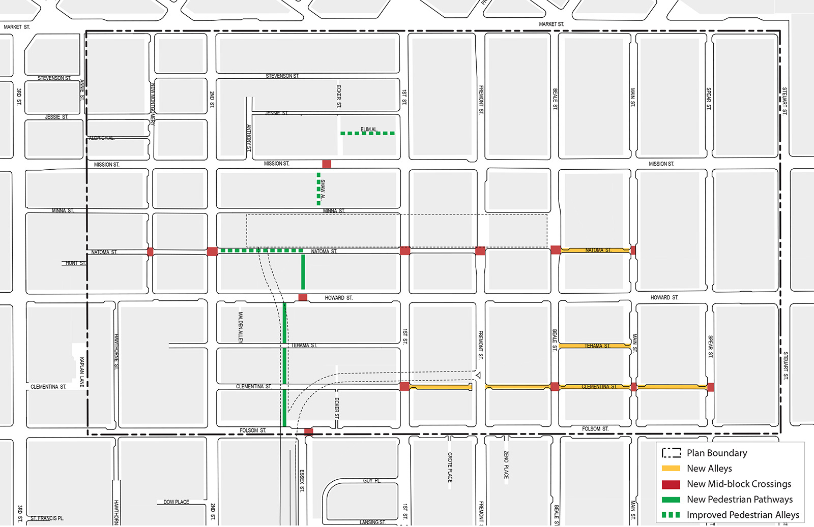
Many of the blocks in the Plan Area are very long, reducing the walkability of the district. The blocks between First and Second streets, in particular, are 850 feet long, necessitating a need for mid-block and through-block connections. The District’s alleyways are a character-defining element of the street fabric. They provide relief for pedestrian circulation, interest and diversity in the pedestrian network, and are critical for loading and parking access off of the main streets. Alleys additionally provide light and air in a dense district and create a more humane, fine scale of development. The Plan proposes to enhance this network by improving existing alleys, creating new mid-block pedestrian passages, as well as adding safe mid-block crossings. These improvements will help disperse pedestrians throughout the District, and allow access to the Transit Center at different points, thereby helping to relieve pedestrian congestion on key corners of major streets around the core of the district.
POLICY 3.10
Create convenient pedestrian access by providing signalized mid-block crosswalks, especially on blocks longer than 300 feet.
New pedestrian mid-block crossings should be introduced to ease access between major activity centers, as well as to help shorten pedestrian walking distances within the District. North-south pedestrian movement should be enhanced through the creation of three new mid-block crossings between 1st and 2nd Streets—on Mission Street near Shaw Alley, on Howard Street at mid-block, and Folsom Street at Essex Street. Several new crossings should be created along Natoma Street—at New Montgomery, Second, First, Fremont, Beale, and Main Streets—to facilitate access to the Transit Center and to emphasize its importance as an east-west pedestrian corridor. Lastly, the Transbay Redevelopment Plan proposes extending Clementina Street east to Spear Street. Mid-block crossings should be created where Clementina Street crosses First, Beale, Main, and Spear Streets to facilitate pedestrian access to the Transbay Park and to emphasize this new corridor.
POLICY 3.11
Prohibit the elimination of existing alleys within the District. Consider the benefits of shifting or re-configuring alley alignments if the proposal provides an equivalent or greater degree of public circulation.
Alleys are critical components of the pedestrian system and the character of the Plan area. Even the shortest and narrowest alleys, while seemingly insignificant in the present, will become ever more necessary as the district density intensifies and the population increases. The City’s General Plan (Urban Design Element Policies 2.8–2.10) acknowledges their importance and already generally prohibits the vacation of public rights-of-way except under unique and extraordinary circumstances in which the demonstrable public benefit of a proposed project requiring the vacation substantially outweighs the loss in public value (both current and potential) of maintaining the right-of-way in public ownership. However, based on other Plan policy and development goals for this District, it may be desirable to “shift” or build over certain narrow alleys for development purposes. In all of these cases, the General Plan explicitly requires the proposal of an actual development proposal for a public-right-of-way prior to consideration of vacation in order to weigh the specific merits of a particular development proposal against the loss of a public right-of-way.
POLICY 3.12
Design new and improved through-block pedestrian passages to make them attractive and functional parts of the public pedestrian network.
POLICY 3.13
Require a new public mid-block pedestrian pathway on Block 3721, connecting Howard and Natoma Streets between First and Second streets.
There are currently no north-south pedestrian connections from Howard to Natoma Streets on the long block between 1st and 2nd Streets. To facilitate pedestrian connections to the Transit Center from the south, a new public passageway is essential on Block 3721 as part of the development of the TJPA’s “Parcel F.” To minimize pedestrian/vehicular conflicts, this mid-block pathway should be located away from any major ramp or driveway accessing a vehicular facility below the Transit Center or off-street parking or loading facility for a building, but should be located close to the mid-block crosswalk planned for this block of Howard Street.
POLICY 3.14
Close Shaw Alley permanently to vehicles and design it as a pedestrian-only open space for thru-connection to the Transit Center.
Shaw Alley is a key link in the pedestrian network feeding the Transit Center from Market Street because of its connection to Ecker Street to the north, as well as to a planned mid-block crossing on Mission Street. A major entrance to the Transit Center is planned at Shaw Alley, as well as a ground-level passage through the Transit Center. The approved project adjacent to Shaw at 535 Mission, as a condition of approval, is to improve the alley and seek at least temporary lunchtime vehicular street closure for use as a pedestrian passageway and café space. However, Shaw should be permanently closed to vehicles once the Transit Center is in operation.
POLICY 3.15
Convert the western portion of Natoma Street between First and Second streets on the south side of the Transit Center to a primarily pedestrian-only street.
The western two-thirds of Natoma Street between First and Second streets will become a critical pedestrian space once the Transit Center is in operation. The ground floor of the Transit Center facing Natoma Street will feature continuous retail shops. The vision for Natoma Street is to create an active retail destination in the alley akin to Maiden Lane and other downtown destination alleys. This portion of Natoma Street will also be very heavily used by pedestrians to access the Transit Center as this will be the primary access point from the south and west; many people on foot are expected to come from the South of Market and Yerba Buena areas south of Howard Street and west of Second Street. It may be feasible and desirable to allow service vehicles and deliveries to access this portion of Natoma Street during the night and early morning hours before the peak transit and retail times. The eastern third of the street near First Street would remain open to vehicles as a two-way street to maintain access to parking and loading for existing buildings on the north side of Howard Street.
Public Open Space
Parks and plazas are vital to the area’s quality of life, helping to foster social interactions and providing places for rest and recharge. As the population and densities within the District increase, open space becomes an increasingly important neighborhood amenity. Not only is there a need to increase the amount of open space, but also the type of space. Different users—from office workers during lunch to special events to downtown residents walking with dogs or playing with their children—require unique open space facilities.
Currently, the primary open spaces in the area are dispersed, mostly small, publicly-accessible but privately-owned spaces constructed as part of buildings since 1985 as a result of zoning requirements adopted in the Downtown Plan. There are no moderate to large open spaces and none that are truly public and managed as public spaces. The nearest large-scale parks are several blocks to the east (Justin Herman Plaza and Rincon Park) and to the west (Yerba Buena Gardens).
There are, however, a few new public open spaces of note currently planned within the Transit Center District as part of the Transit Center itself and as part of the redevelopment of public parcels in Zone 1 of the Transbay Redevelopment Area. At 5.4 acres, the park planned for the roof of the Transit Center, dubbed “City Park,” will be the District’s “Central Park.” As proposed, the park will be a self-sustaining ecosystem, allowing for a variety of both passive and active activities, educational experiences, special events, as well as habitat for local wildlife. Also part of the Transit Center development, Mission Square will serve as the grand entrance to the new station at the corner of Fremont and Mission Streets. On the block bounded Beale, Main, and new extensions of Tehama and Clementina Streets, the City (in its role as the successor to the Redevelopment Agency) will build a new 1.1-acre Transbay Park once the Transit Center is operational. There are other ideas under consideration that the areas below the bus ramps serving the Transbay Transit Center could be improved with recreational amenities, such as sport courts or dog runs, to serve the neighborhood.
To augment these spaces, this Plan proposes a new public plaza at the northeast corner of Howard and Second Streets. Measuring one half an acre, this plaza will connect the Transit Center Park with the public realm at street level and provide a southern gateway to the Transit Center.
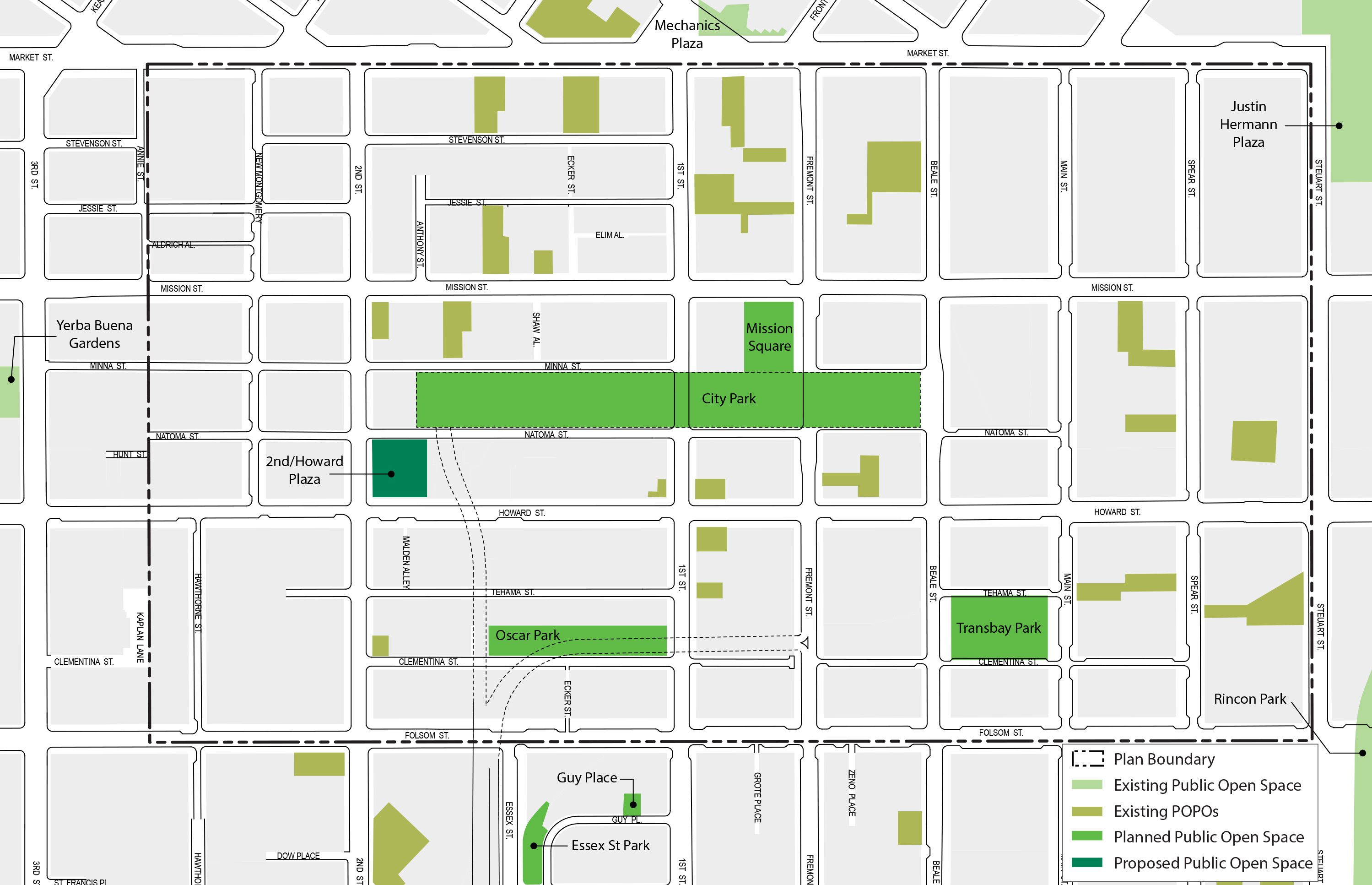
OBJECTIVE 3.10
ENHANCE THE OPEN SPACE NETWORK IN THE AREA TO SERVE INCREASING NUMBERS OF WORKERS, RESIDENTS, AND VISITORS.
POLICY 3.16
Create a new public plaza at the northeast corner of Second and Howard streets.
A number of parcels on the northeast corner of Second and Howard must be acquired by the TJPA to construct the Downtown Train Extension. These parcels have a severely limited development potential because the train tunnel’s curvature and envelope below grade restricts the feasibility of construction above. As a result, the best possible use of the site is to create a new public space, designed to fit within the context of the historic district.
This open space has the capacity to be a major access point to the adjacent elevated Transit Center Park, as well as to provide a significant entry to the Transit Center itself. The central location of this space could accommodate a restaurant, retail or other uses, supported by both foot traffic from Second and Howard Streets, and transit and park users. Lastly, since train construction requires the demolition of on-site historic buildings, portions of these buildings could be reused as part of the new plaza design.
OBJECTIVE 3.11
ENHANCE ACCESS AND MAXIMIZE THE VISIBILITY OF THE TRANSIT CENTER’S FUTURE ROOFTOP PARK FROM THE SURROUNDING NEIGHBORHOODS, ESPECIALLY NEIGHBORHOODS TO THE SOUTH.
The Transit Center Park will be the largest public open space within the downtown and will be a unique and special place at the heart of this dense district. It should be celebrated and its use encouraged with grand, welcoming and highly-visible means of access for the public in addition to those provided from within the Transit Center itself, from key public spaces abutting the Transit Center, particularly Mission Square, as well as from adjacent private buildings, particularly the Transit Tower. Being 70 feet above grade, the Park will require numerous access points to maximize its visibility and active use besides the access points provided from within the Transit Center building itself. To ensure that the public can take advantage of the major public amenity of the Park it is critical to weave into the neighborhood enhanced public access to the Park from as many points as possible. Any external access to the Transit Center Park will need approval from the TJPA. The City, TJPA, developers and property owners should work cooperatively to meet the intents and spirit of these policies.
POLICY 3.17
Ensure that highly-visible, welcoming, and grand means of public access to the Transit Center Park are provided directly from key public spaces and buildings adjacent to the Transit Center.
The most prominent opportunities to provide public access to the Transit Center Park are Mission Square and the Transit Tower. Mission Square is the front door of the Transit Center and the primary public space adjacent to it. Public access directly to the Park from Mission Square through the Transit Tower (which is adjacent to Mission Square and in front of the Transit Center), should also be provided because of the Tower’s location, size and public significance. Another key opportunity for direct access from adjacent public spaces will be from the proposed 2nd/Howard Plaza.
POLICY 3.18
Encourage the rooftop Transit Center Park to remain open from sunrise to sunset, seven days a week.
POLICY 3.19
Permit buildings to satisfy open space requirements through direct connections to the Transit Center Park.
Existing General Plan policy is to significantly discourage or prohibit any building connections (i.e. footbridges) over rights-of-way. This strong policy exists in order to preserve view corridors down streets—both major and minor streets—as they are major public assets, wayfinding devices, and defining characteristics of San Francisco. Only under limited and unique circumstances of overriding public benefit, where impacts to views and the streets below are demonstrably minimal, are such bridges considered acceptable.
The alleys abutting the Transit Center—Minna and Natoma—generally do not continue eastward of 1st and Fremont Streets respectively, and bus ramps already cross Natoma between 1st and 2nd Streets. Connections to the Transit Center park from adjacent buildings fronting Minna and Natoma would therefore create minimal impact to view corridors and to the streets below, while providing significant public benefit in the form of public access and activation of the park.
Buildings immediately abutting the Transit Center or along Minna and Natoma Streets opposite the Transit Center are encouraged to partially satisfy their Planning Code Section 138 publicly-accessible open space requirements by providing a direct pedestrian connection to the Transit Center Park. These connections, however, should be limited to select locations in order to minimize structures over alleyways. This Plan does not support such direct connections across the major streets in the District, as the value of direct connections to the Transit Center Park does not outweigh the value of protecting the visual axes of these streets.
POLICY 3.20
Consider extending the Transit Center rooftop park along the new bus ramp, so that it connects to a possible future Bay Bridge multiuse pathway.
With a new Bay Bridge bicycle and pedestrian pathway currently underway to connect Oakland and Yerba Buena Island, the possibility of having a connection across the Bay to San Francisco is becoming closer to reality. If this is the case, the top deck of the Transit Center’s new bus ramps could serve as a potential route for continuation of a Bay Bridge Multi-Use Path, terminating at the rooftop Transit Center Park. Besides increasing regional access to the Transit Center Park, it would provide an attractive “landmark” embarkation and arrival point in downtown for pedestrian trips on the Bay Bridge.
Privately-Owned Public Open Space
Section 138 of the Planning Code requires all new non-residential development projects to provide publicly-accessible space to meet growing needs for open space. Much of the existing open space now within the District is comprised of these privately-owned public open spaces, or “POPOS.” Many of these spaces are successful additions to the downtown open space network, but changing circumstances suggest that some changes to this approach in the Transit Center District would be beneficial:
-
The proposed Plan makes possible very large and dense buildings, many on lots not much bigger than the footprints of the buildings themselves. It becomes physically impossible for some buildings to provide the Code required open space on-site.
-
An over-production of plazas adjacent to every large building is beginning to erode the urban fabric. The public realm of the street, the “urban room,” should be framed by a consistent streetwall of buildings. It should occasionally be punctuated by open public spaces and public ways and not characterized by the pattern of alternating plazas and buildings.
-
Many of these privately-owned public spaces face a difficult challenge to make them genuinely feel and function as “public,” thereby fulfilling the intent of the requirement. These spaces, many indoors or tucked behind, within, or on top of buildings, can be difficult to find, and their design and management limits their usefulness as true “public” spaces.
Modification to policies and regulations to offset these trends are outlined below. These policies and proposals are aimed at creating more flexibility in how private resources are used to meet open space requirements. It also seems clear that more attention to the design and management of POPOS (i.e. more than just spaces for lunch) is warranted to evolve their usefulness and contribution to a growing and maturing downtown.
OBJECTIVE 3.12
ENSURE THAT PRIVATE OPEN SPACE BOTH ENHANCES THE PUBLIC OPEN SPACE NETWORK AND ACHIEVES THE PLAN’S OPEN SPACE GOALS.
OBJECTIVE 3.13
PROVIDE FLEXIBILITY AND ALTERNATIVES TO MEETING OPEN SPACE REQUIREMENTS THAT ACHIEVE THE DISTRICT’S OPEN SPACE VISION, AND THAT ENHANCE AND IMPROVE ACCESS TO PLANNED PUBLIC SPACE, PARTICULARLY THE TRANSIT CENTER PARK.
POLICY 3.21
Permit payment of an in-lieu fee as an alternative to fulfilling Section 138 Open Space Requirements in C-3 Districts.
POLICY 3.22
Permit and encourage buildings to satisfy open space requirements through direct connections across Minna and Natoma Streets to the Transit Center Park.
OBJECTIVE 3.14
ENSURE THAT INDOOR OPEN SPACE FUNCTIONS AS PUBLIC SPACE INDEPENDENT OF THE BUILDING’S PRIMARY USES.
POLICY 3.23
Design interior open spaces to have a distinct street presence separate from the building’s primary building entrance and lobby functions
OBJECTIVE 3.15
ENCOURAGE PROVISION OF PUBLICLY ACCESSIBLE AMENITIES IN THE DISTRICT’S TALLEST TOWERS.
POLICY 3.24
The tallest buildings in the District should have a facility of public accommodation at a level no lower than 650 feet above grade that provide the general public the opportunity for views of the cityscape and Bay.
The general public should have the ability to enjoy panoramic views from the tallest building in the city and region. With such an unparalleled and unique regional amenity, these towers enjoy a privilege that must be shared with the public, not just building tenants.
Such facilities may include observation decks, restaurants, bars, lobbies, or any space accessible to the general public, and which does not require an appointment or membership, but which may charge a nominal fee for entrance (to cover the costs of maintenance). The Transit Tower and other tall buildings (greater than 600 feet tall) are encouraged to provide such amenities
Moving About
Introduction
The Downtown Plan has guided the substantial growth of downtown (including the Transit Center District) largely on the back of transit. Since 1985, the total built space in downtown has increased by about 25 percent, including 19 million square feet of office space. Traffic congestion and auto travel, however, has not increased commensurately. In other words, the growth in downtown jobs and residents—and the resulting growth in the City’s tax base—has been dependent on the City’s and region's commitments to enhancing local and regional transit service and getting most people to downtown San Francisco without autos. The success of the Transit Center District Plan will hinge on maintaining this “transit first” commitment.
The development of the new Transbay Transit Center—the “Grand Central Station of the West”—and development in the Transit Center District will both create and necessitate a significantly enhanced transit service beyond what downtown San Francisco enjoys today. With a focus on transit as the primary mode of moving people into and throughout the District, the accommodation of growth (let alone current levels) in automobile traffic cannot be prioritized. Instead, a rich public realm that supports large amounts of pedestrian activity can be created. The Transit Center District Plan’s vision is to enhance the function of surface transit and manage vehicular traffic in order to transform the District’s streets into memorable, active, and world-class public spaces that support walking and bicycling, that encourage and support social activity, and that create a vibrant urban center made particularly unique by its focus around the new Transbay Transit Center.
Anticipated growth and the location of the Transit Center in this district necessitate considerable improvements to the transportation system and rights-of-way that support transit and encourage travel by non-auto modes. This future cannot be achieved based on the current design of the area’s streets and management of its circulation system. The majority of trips to and through the District must occur via non-auto modes, or proposed growth in the District will be stifled and congestion will bring the city’s core transit network to a standstill.
In order to transform the District’s public realm into a great place for people to get around safely and conveniently and to prepare for its new workers, residents, and visitors, this Plan recommends infrastructure improvements, transit enhancements and Transportation Demand Management (TDM) policies that will:
- Create great urban streets that promote walking and bicycling,
- Support high-quality transit service (including improved travel time performance as well as passenger amenity and comfort),
- and Actively manage auto congestion.
This section contains the objectives, and proposed implementing actions (policies and controls) to achieve these outcomes. Many of the proposed implementing actions build off the success of existing policies and programs that have been in place for decades, including the Downtown Plan, Transit First Policy, and recent efforts to manage parking supply and demand in order to reduce per capita vehicle trips and to help surface transit become faster and more reliable. As a result of these efforts, the greater downtown area already has substantially higher rates of transit use, carpooling, biking, and walking compared to the rest of the region and the rest of the city.
The Downtown Plan sets performance measures to reduce the effects of downtown growth on traffic congestion, and while many of its policies have been successful, some important performance measures have not been met, including limiting the growth of the commuter parking supply and increasing the rates of carpooling (as measured by AVR, or Average Vehicle Ridership). The Downtown Plan’s goal for increasing transit mode share has been more successful in the financial district core with diminishing success outwards.
The Moving About section proposes several new implementing actions for improving the transportation network in the District. These new policies and controls build on previous successes, but they also go beyond existing measures to balance the role of the Transit Center District as a major multi-modal point of arrival and embarkation for the entire Bay Area, a regional employment center and recreational destination, and as an evolving San Francisco neighborhood.
What follows is a series of objectives and policies that seek to modify excessive auto traffic through the District in favor of transit, walking, and other means of circulation. Successful traffic management will make possible a new place at the core of the city, one that attracts a dense mix of commerce and people because of its bright vitality and pleasant environment. Not all of these recommendations need to be implemented or initiated immediately. Their timing will depend on the pace of the District’s development and monitoring of various factors, including public transit performance. Several policies call for further evaluation of possible improvements to circulation and the street environment. This approach is taken because the complexities of the central district and some of the recommendations need to be understood in a larger context for their effects on various systems.
Overall Objectives
OBJECTIVE 4.1
THE DISTRICT’S TRANSPORTATION SYSTEM WILL PRIORITIZE AND INCENTIVIZE THE USE OF TRANSIT. PUBLIC TRANSPORTATION WILL BE THE MAIN, NON-PEDESTRIAN MODE FOR MOVING INTO AND BETWEEN DESTINATIONS IN THE TRANSIT CENTER DISTRICT.
OBJECTIVE 4.2
THE DISTRICT’S TRANSPORTATION SYSTEM WILL IMPLEMENT AND REQUIRE TRANSPORTATION DEMAND MANAGEMENT STRATEGIES TO MINIMIZE GROWTH IN AUTO TRIPS AND REDUCE VOLUMES AS NECESSARY. ACTIVELY MANAGE THE TRANSPORTATION SYSTEM TO OPTIMIZE PERSON-CARRYING CAPACITY.
OBJECTIVE 4.3
THE DISTRICT’S TRANSPORTATION SYSTEM WILL MEET CHANGING TRANSIT NEEDS, PARTICULARLY TO SUPPORT THE NEW TRANSBAY TRANSIT CENTER AND ACCOMMODATE INCREASED DENSITIES. MAKE CHANGES IN THE CIRCULATION NETWORK THAT ENSURE DELIVERY OF RELIABLE AND CONVENIENT TRANSIT SERVICE TO THE TRANSBAY TRANSIT CENTER AND FOR DISTRICT RESIDENTS, EMPLOYEES, AND VISITORS.
OBJECTIVE 4.4
THE DISTRICT’S TRANSPORTATION SYSTEM WILL PRIORITIZE PEDESTRIAN AMENITY AND SAFETY. INVEST IN CIRCULATION MODIFICATIONS AND URBAN DESIGN MEASURES THAT SUPPORT THE CREATION OF AN ATTRACTIVE AND MEMORABLE PUBLIC REALM.
OBJECTIVE 4.5
THE DISTRICT’S TRANSPORTATION SYSTEM WILL BUILD ON SUCCESSFUL TRAFFIC AND PARKING MANAGEMENT PROGRAMS AND POLICIES THAT ARE IN PLACE. EXPAND AND STRENGTHEN EXISTING ADOPTED POLICIES (E.G. DOWNTOWN PLAN, C-3 PARKING CONTROLS) AND CURRENT PLANNING INITIATIVES (E.G. TRANSIT EFFECTIVENESS PROJECT, SFPARK).
OBJECTIVE 4.6
THE DISTRICT’S TRANSPORTATION SYSTEM WILL REQUIRE MANAGEMENT OF BAY BRIDGE QUEUES TO REDUCE AND MITIGATE IMPACTS OF REGIONAL TRAFFIC ON TRANSIT CIRCULATION AND THE PUBLIC REALM IN THE DISTRICT.
OBJECTIVE 4.7
THE DISTRICT’S TRANSPORTATION SYSTEM WILL FURTHER SUSTAINABILITY GOALS. ADVANCE THE GOALS OF THE CITY’S CLIMATE ACTION PLAN, BY REDUCING GREENHOUSE GAS EMISSIONS GENERATED BY VEHICULAR TRANSPORTATION.
Transit
Public transportation is fundamental to accommodating the movement of large populations of workers and residents to, within and through the city. Transit is the very backbone of the downtown’s infrastructure and enables its day-to-day function and its continued sustainable growth. Levels of density and activity, such as currently exist in the downtown and as proposed for the District, are possible only through the overwhelming majority of its workers, visitors, and residents relying on transit to move about. A circulation network that prioritizes transit will support the creation of the public spaces, walking environment and bicycle network that are envisioned for the Transit Center District. Moreover, the Transbay Transit Center is the central hub of San Francisco’s and the region’s transit network, and service delays or problems in the Plan Area can radiate throughout the network. For these reasons it is critical to facilitate transit movements in the District, as well as to and from the Transbay Transit Center.
OBJECTIVE 4.8
DESIGN THE CIRCULATION SYSTEM AND TRANSIT FACILITIES TO ACCOMMODATE ANTICIPATED GROWTH IN TRAVEL TO AND THROUGH THE DISTRICT IN 2030 AND BEYOND.
OBJECTIVE 4.9
PRIORITIZE TRANSIT MOVEMENTS THROUGH AND WITHIN THE DISTRICT OVER ALL OTHER TRANSPORTATION MODES.
OBJECTIVE 4.10
DESIGN TRANSIT FACILITIES TO IMPROVE THE RELIABILITY AND FUNCTION OF TRANSIT MOVEMENTS AND TO ENHANCE THE RIDER EXPERIENCE.
OBJECTIVE 4.11
ENSURE THAT CHANGES TO THE CIRCULATION NETWORK, INCLUDING PEDESTRIAN AND STREETSCAPE IMPROVEMENTS, ARE DESIGNED TO SUPPORT AND ENHANCE THE OPERATION OF TRANSIT.
All infrastructure improvements and right-of-way management should strive to:
- Provide dedicated transit space (not porous to conflicting traffic)
- Create high-quality stations and passenger experiences (real “places”)
- Provide transit riders with “front-door service” to key destinations (not 2nd-class treatment)
- Provide inter-agency benefits (improvements that benefit other transit providers, if possible)
- Improve operational reliability
- Provide overall improvements to the quality of service
- Increase operating speeds (from current 6mph average to at least 10mph)
POLICY 4.1
Extend self-enforcing, dedicated transit lanes throughout the district.
Dedicated transit lanes expedite surface transit movement, improve transit travel time, and support more efficient operating costs by allowing for more reliable and consistent headways, especially during peak hours.
Existing dedicated transit lanes in the vicinity are located along Third Street (outside of the plan area); Mission Street; and on First and Fremont streets between Market Street and the existing Transbay Terminal. These transit lanes are not currently self-enforcing. As a result, automobiles can drive in the transit lane unless manual enforcement is available. As resources for manual enforcement is limited, conflicts with vehicular traffic occur often, impacting delivery of transit service in the District.
To improve transit flow and facilitate the future movement of transit through the District and to and from the Transit Center, existing transit lanes should be upgraded to be self-enforcing, and new self-enforcing transit lanes will be necessary in the following locations:
- Fremont Street between Howard Street and Mission Street
- Beale Street between Market Street and the Transbay Transit Center
SFMTA is considering the need for possible service expansion of the 1-California line along Main and Beale streets. A final determination regarding this service has not been made and will be subject to ongoing evaluation of travel patterns in the emerging Transbay/Rincon Hill residential area. It is important to note that should this service be enhanced, and the engineering and design of a transit lane on Main Street must be considered. In the Transit Center District Plan, Main Street is proposed to be reconfigured as an extension of the Living Street design concept, in which case an engineering solution, such as a timed “transit-only” lane may be suitable during peak periods. SFMTA is committed to identifying balanced solutions that solve critical transit needs while achieving the desired character of the District’s streets and public realm.
To acknowledge potential service modifications, transit lane enhancements may be necessary on:
- Main Street between Market and Bryant streets
In addition to local surface transit, inter-city buses (e.g. Amtrak, Greyhound, “airporter” type buses serving High Speed Rail), operate on city streets, many circulating from an inter-city bus plaza to be built at the east end of the Transit Center, located between Beale and Main streets. Many of these buses are destined for the Bay Bridge and need dedicated access to avoid being stuck in general auto queues.
Dedicated transit lanes on the following streets may be necessary to support inter-city buses (and will already be in place as part of the Temporary Transit Center while the new Transit Center is under construction):
- Folsom Street (westbound) between First and Essex streets
- Essex Street (southbound)
POLICY 4.2
Design all transit lanes to be self-enforcing and to heighten awareness of transit facilities.
The design of transit lanes to make them self-enforcing is critical to their success. When transit lanes are self-enforcing, the imposition of vehicular traffic into the transit lane is less-likely, difficult or not possible at all. Without this treatment, transit lanes have limited effectiveness, as illustrated in the District today by cars regularly impeding the movement of busses by driving and parking in transit lanes.
To the extent possible, all transit lanes within the District must be designed as self-enforcing, dedicated transit lanes. Some design and engineering techniques that have been successful to these ends include textured or colored paving, raised pavement that elevates transit lanes above vehicular travel lanes (such as on Judah Street in the Sunset District), and physical elements delineating or separating transit lanes from other lanes, such as curbs, rumble strips or features that exclude low-clearance vehicles. Another technique that enhances the self-enforcing character of transit lanes is locating them in the center of the roadway (rather than curb-side), where experience has shown improvements to transit mobility and effectiveness and reduced conflicts from vehicles, such as by double parking and making right turns.
Future District streetscape projects and other construction on streets with transit lanes will implement measures to ensure the highest level possible of transit lane self-enforcement. The Plan’s proposed funding program dedicates money for this purpose.
POLICY 4.3
Evaluate the concept for a transit-only zone on Mission between First and Fremont streets.
Mission Street in front of the Transbay Transit Center, between First and Fremont streets, will become an exceptionally busy place, bustling with transit and pedestrian traffic. Almost all of the Transit Center-bound buses, except for AC Transit, and including Muni, Golden Gate Transit, and SamTrans converge on this block, providing service at the front door of the Transit Center. Several Muni lines coming from Market Street that terminate at the Transit Center will head south on First Street from Market and then turn left onto Mission Street, dropping all passengers in front of the Transit Center and Transit Tower. The high-frequency Mission Street Muni buses (designated as a “Rapid” line in the TEP) also use this stretch, plus many of the other regional bus carriers. In addition to all of the transit movements, there will be thousands of pedestrians moving about, particularly in peak hours, when many trains, both Caltrain and High Speed Rail, arrive and depart each hour. Added to this transit-related activity will be a substantial general increase in pedestrian traffic from development growth in the immediate area (not least of which the Transit Tower and major development near the northwest corner of First and Mission streets).
The concept of creating a transit-only zone on this block of Mission deserves additional study for a number of reasons from both a transportation and place-making standpoint. Besides simplifying the traffic on the block to allow for heavy, frequent volumes of transit and pedestrians, this concept could reduce auto volumes overall on Mission Street. This could have benefits to transit west of the Plan Area and help mitigate any diversionary effects of auto restrictions on Market Street that might otherwise impact transit on Mission Street. As important as the circulation issue, is the goal of creating a special place in front of the Transit Center to celebrate and mark its presence (and that of the Transit Tower) in the downtown public realm as a hub of activity and social interaction. In order to create a special destination event in the urban landscape, the influence of the Transit Center and Mission Square plaza should expand to encompass the street in front of the Transit Center and should break the continuity of the general patterns of circulation.
OBJECTIVE 4.12
PROVIDE HIGH-QUALITY FACILITIES AND EXPERIENCE FOR TRANSIT PASSENGERS.
POLICY 4.4
Provide sidewalk space and facilities for enhanced transit stops with passenger amenities on Mission Street and other primary transit streets.
Prioritize amenities and infrastructure to improve passenger experience and convenience and to improve the performance of the transit system. Elements such as enhanced stops with ticket machines, maps, real-time arrival information, bicycle parking and other supportive facilities, in addition to other streetscape infrastructure and amenities, can support expeditious boarding and alighting and improve operations.
OBJECTIVE 4.13
SUPPORT ENHANCED FUNDING AND CAPACITY FOR REGIONAL TRANSIT SERVICE TO SUPPORT INCREASES IN POPULATION AND EMPLOYMENT GROWTH AS WELL AS SHIFTS FROM AUTO TO PUBLIC TRANSIT TRAVEL.
As downtown San Francisco is a regional job center, up to half of all workers in the city commute from homes outside of the city, making improvement and expansion of regional transit service imperative to support downtown and continued growth.
POLICY 4.5
Support funding and construction of the Transbay Transit Center project to further goals of the District Plan, including completion of the Downtown Extension for Caltrain and High Speed Rail.
POLICY 4.6
Ensure that regional transit carriers operating on city streets are prioritized along with local transit by implementing the surface transit priority improvements proposed in this plan.
POLICY 4.7
Work with BART to identify and fund measures to increase capacity as necessary to serve the District, particularly at the Montgomery and Embarcadero stations.
The two BART stations serving the Transit Center District area are the Montgomery and Embarcadero stations. As ridership continues to rise, capacity constraints during peak periods become a problem. For BART, the initial constraints are not expected to be with the “line haul” capacity per se, but more with the stations themselves, in terms of crowding on platforms, vertical circulation, and the “dwell time” required for trains to load and unload passengers. The Transbay Tube itself is not necessarily a constraint in the system to accommodate growth. BART is currently in the process of designing and planning to procure new 3-door cars with higher capacity in order to accommodate expected passenger volumes, and expanding the size of the fleet to extend more trains in the peak period to 10-car trains. The use of 3-door cars would speed the boarding process and serve a higher number of passengers in existing stations without changes to service levels and without increasing dwell times that slow the system. BART is also in the process of designing improvements to the train control system to allow for more frequent peak service, which will also reduce train and station crowding. Other measures that BART can take to increase station capacity in the future include platform edge doors, better public information regarding train arrivals at concourse and street levels, and other transportation management strategies. With the measures described here, the capacity of these stations would increase by about ten percent.
OBJECTIVE 4.14
SUPPORT ENHANCED FUNDING AND CAPACITY FOR LOCAL TRANSIT SERVICE TO SUPPORT INCREASES IN POPULATION AND EMPLOYMENT GROWTH AS WELL AS SHIFTS FROM AUTO TO PUBLIC TRANSIT TRAVEL.
POLICY 4.8
Support revenue measures and investments essential to enhancing Muni’s capacity, reliability and operational efficiency in providing service to and within the District.
The existing Transit Impact Development Fee is assessed on all commercial development and goes exclusively to San Francisco’s Muni to increase capacity and service to support this growth. These fees do not address all of the capital and operational expenses necessary to improve and expand local transit service within the city, especially if additional shifts are encouraged and expected from autos to transit.
Transportation Demand Management
Transportation Demand Management (TDM) is a term for measures and regulations that reduce travelers’ use of autos and encourage a behavioral and preferential shift toward transit, carpooling, bicycling, walking, and other non-single-occupant vehicle means of getting around. The Downtown Plan contained two primary transportation targets to accommodate growth with minimal increases in traffic congestion and maximal improvement to the quality of life in the downtown (and beyond): increase vehicle occupancy on the major routes into the City from 1.48 to 1.66 persons per vehicle and increase transit mode share from 64 to 70 percent.
Evidence suggests achieving these goals has been mixed. Though somewhat dated, a focused survey of member office buildings conducted in 2000 by the Transportation Management Association of San Francisco indicated that 77 percent of commute trips to the core Financial District were made by public transit, while 17 percent were made by auto (including carpooling). But data compiled from the 2000 Census by the Metropolitan Transportation Commission (MTC) for the broader downtown, encompassing the entire C-3 zone and adjacent areas (i.e. “Superdistrict 1”), showed that 49 percent of workers took transit, 41 percent of commuters came by auto (including 29% who drove alone to work) and about 10 percent took other means (primarily walking and bicycling).3 Moreover, vehicle occupancy trends (i.e. number of people per vehicle) also appear counter to the intentions of the Downtown Plan. Evidence reviewed in the 2004 Downtown Monitoring Report indicate that vehicle occupancy on both major bridges into the City have declined since 1985. Bay Bridge peak hour occupancy declined from over 2.0 in 1985 to under 1.5 in 2000, and Golden Gate Bridge occupancy declined from 1.35 in 1985 to 1.25 in 1993.
While the number of commuters driving to work is considerably less than other Bay Area communities, downtown San Francisco still struggles with traffic congestion, particularly in the evening peak hours and much of it bound for the Bay Bridge. This congestion negatively impacts public transit performance and diminishes the street environment for walking and bicycling. Completion of the new Transbay Transit Center, an increase in transit service in the District, continued land use growth, and the creation of an improved public realm all require traffic congestion to be managed through a series of demand management strategies. Transportation Demand Management (TDM) is critical to the success of the Transit Center District Plan and is an essential tool in shifting trips, particularly in peak hours, from auto to public transit and other means of moving about the city.
OBJECTIVE 4.15
USE DEMAND MANAGEMENT STRATEGIES TO REDUCE OVERALL LEVELS OF AUTO TRAFFIC IN THE PLAN AREA AND DOWNTOWN, PARTICULARLY IN THE PEAK HOURS, IN ORDER TO REDUCE AUTO IMPACTS ON OTHER TRANSPORTATION MODES AND ENABLE THE CREATION OF A HIGH QUALITY PUBLIC REALM.
POLICY 4.9
Complete a detailed traffic analysis for the downtown and the District specifically to determine which TDM measures will be most effective and necessary to reduce traffic volumes and traffic impacts on the District.
POLICY 4.10
Update the goals of the Downtown Plan and establish specific targets for cumulative traffic volumes and non-auto travel that are necessary to achieve the conditions that enable the flow of transit, the flow of local circulation, and the creation of the public realm infrastructure as proposed by the Plan.
All projections indicate that, without significant intervention, the level of the auto traffic in the downtown and the Plan Area specifically will cause the streets in the District to reach gridlock levels over the course of the Plan’s horizon—even without any added growth in the Plan Area. Many streets in the District are already at substantially degraded and congested conditions, especially in the peak commute hours. The effects of the present and future degradation of traffic conditions would substantially impair the basic circulation of surface transit (e.g. Muni, Golden Gate Transit), and hinder the ability of necessary local circulation and commercial activity to function, in addition to causing substantially unpleasant and potentially unsafe conditions for pedestrians and cyclists.
Further analysis of the circulation and public realm system necessary and desirable to support the District will enable the determination of maximum traffic volumes that can be accommodated without compromising the system and the quality of place.
While the Downtown Plan established per-capita and per-vehicle metrics as core transportation goals, achieving these targets will likely not be sufficient to achieve the necessary vehicle reductions, as actual cumulative trips would continue to grow with continued land use growth and intensification. What are needed are actual absolute targets based on the capacity of the circulation system to handle vehicles without stifling movement.
Additionally, rather than focusing exclusively on transit mode share, the metrics should speak to all non-auto modes cumulatively, as walking and bicycling trips continue to grow as a share of overall trips into and within the District. For instance, the number of bicycle trips in the downtown has grown steadily over the past several years, increasing by 36 percent from 2006-2008 alone to over 3,400 cyclists in the peak hour in the downtown in 2008,4 representing a commute mode share for cycling comparable to or greater than some major public transit modes, such as ferries or even Caltrain.
Metric goals for the Transit Center District, as a sub-area of the downtown, should be established that are more ambitious than those for the downtown as a whole. A target of at least 95 percent non-auto modes for all trips into and around the District should be achieved (which is consistent with the current auto parking restrictions in the C-3 districts that allow a maximum of about one space per 20 workers). A minimum transit share of 80 percent for transit should be easily feasible (considering the evidence that approximately 75% of workers currently take transit to work in the core financial district), plus a combined walking-biking share goal of 15 percent.
POLICY 4.11
Study the feasibility of and implement, as feasibility and necessity determines, congestion pricing of roadways as a primary tool to reduce overall traffic levels in the Plan area, particularly peak-hour bridge and freeway queues.
Without pricing intervention, it is unlikely that the necessary volume reduction targets could be met in the downtown as a whole and the District specifically. The reduction of traffic volume in the district likely cannot wholly be achieved by regulation of quantity and pricing of parking either in the District or the downtown more broadly. Much of the existing traffic originates outside of the downtown and uses the streets of the District to access the bridge and freeways. Even if traffic is re-routed around the core of the downtown, it is likely that some form of roadway pricing would also be needed to reduce volumes sufficiently to achieve the necessary improvements for transit, pedestrians, cycling, and public space required to support the growth contemplated by the Plan.
The City and County, through the appropriate implementing agencies, such as the MTA and the County Transportation Authority, should work to complete the necessary analyses to determine the appropriate triggers, mechanisms, and scope for a congestion pricing program, and implement it. Such a program could ultimately take multiple forms that vary in physical parameters (e.g. boundaries and cordon points, such as freeway ramps or broader district edges), temporal parameters (e.g. time of day, day of week), and other factors; the program would have to be tailored over time as necessity and feasibility dictate. Further, funds raised from such a program should be directly funneled into improvements and capacity enhancements to public transit, walking, cycling, car sharing, taxi and other non-auto infrastructure. This Plan dedicates some funding to contribute to the completion of the necessary studies and the implementation of such a program.
TDM: Automobile Parking Supply and Management
OBJECTIVE 4.16
CREATE A PARKING PLAN THAT ENCOURAGES THE USE OF PUBLIC TRANSIT AND OTHER MODES OF TRANSPORTATION THAT ARE ALTERNATIVES TO SINGLE-OCCUPANT VEHICLES.
The availability and cost of automobile parking play a major role in determining whether or not people choose to drive, particularly to areas that have high levels of transit service such as the Transit Center District. When parking is readily available and inexpensive, workers and visitors are much more likely to drive to and within the city, and less likely to take transit, to bicycle, or to walk. These commuters have the greatest impact on downtown’s circulation network, particularly during peak commuting periods. These impacts are magnified within the Transit Center District, as the District’s streets are both core corridors in the entire city’s transit network and main access ways to Bay Bridge on-ramps. Back-ups during peak commute hours can extend many blocks, resulting in significant delays to the citywide transit system. Controlling the availability and cost of parking is one of the most proven, effective, and essential TDM tools to tamper growth in auto use, and has been one of the foundations for managing the transportation system to support the continued growth of downtown since before the Downtown Plan was adopted.
TDM: Incentives, Brokerage and Monitoring
OBJECTIVE 4.17
CREATE AND ENSURE COMPLIANCE WITH MECHANISMS THAT PROVIDE WORKERS AND RESIDENTS WITH INCENTIVES TO TAKE TRANSIT AND USE MODES OF TRANSPORTATION OTHER THAN SINGLE-OCCUPANT AUTOS.
POLICY 4.12
Ensure compliance with the Commuter Benefits Ordinance.
POLICY 4.13
Pursue creation of requirements for transportation incentives and brokerage services for large residential properties in the District.
While the Commuter Benefits Ordinance provides incentives for employees working in San Francisco to use transit or modes of transportation other than single-occupant autos, many city residents work for employers outside of the city, work for employers smaller than are covered by the Ordinance, or are not employed. Just as large commercial developments are required to provide transportation brokerage services for on-site workers, possibly too should large residential developments as a way to encourage transit usage among its residents (whether owners or renters). A standard set of conditions or incentives should also be considered as requirements for large residential properties. Such conditions may include subsidized transit passes, car sharing memberships, or other services.
OBJECTIVE 4.18
ENCOURAGE THE USE OF NON-AUTO MODES OF TRANSPORTATION BY REQUIRING PARTICIPATION IN A TRANSPORTATION DEMAND MANAGEMENT PROGRAM IN NEW BUILDINGS THROUGHOUT THE DISTRICT.
OBJECTIVE 4.19
ENSURE THAT BROKERAGE AND TDM REQUIREMENTS ARE APPROPRIATE FOR CURRENT AND FUTURE TRAVEL PATTERNS FOR THE DISTRICT AND DOWNTOWN, ARE DESIGNED FOR GREATEST EFFECTIVENESS WHILE MAINTAINING FLEXIBILITY, INCLUDE ALL MODES OF TRANSPORTATION, AND PROVIDE A TOOLKIT OF FINANCIAL INCENTIVES TO REDUCE AUTO TRIPS.
POLICY 4.14
Reduce the size threshold for new and renovated buildings to trigger the requirement for transportation demand management and participation in the Transportation Management Association (TMA).
POLICY 4.15
Expand the TMA requirement to include non-office uses, including hotels, large retail, cultural, and institutional uses.
POLICY 4.16
Require commercial property managers or owners to monitor and report yearly mode split or peak-hour vehicle trips of their employees and to increase or modify TDM programs if targets are not being met.
POLICY 4.17
Fund a comprehensive study to develop recommendations on the structure, operations, and authority of the existing downtown Transportation Management Association (TMA), update the goals and tools available to the TMA, and evaluate whether a district specific TMA is needed.
POLICY 4.18
Expand the purview and funding of the existing downtown Transportation Management Association (TMA) or create a district-specific TMA.
POLICY 4.19
Require that the downtown Transportation Management Association (TMA) duties, programs, and funding be reviewed and updated every 5 years and updated if necessary.
POLICY 4.20
Develop a transportation monitoring and enforcement plan for the district based on adopted performance measures; to be implemented by the TMA with annual reports submitted to Planning and San Francisco Municipal Transportation Agency.
The Transportation Management Association of San Francisco (TMA SF) was established in 1989 to enable developments to fulfill the requirements of Section 163. As a privately funded, non-profit organization, the TMA provides information to the general public and businesses on commute options for all modes of transportation. The goals, objectives, and requirements of the TMA were adopted in 1989. The original objectives and goals have not been updated since that time, although these may be updated every five years when the TMA provides its proposed work scope for the next five years and reports on its past performance.
Walking
As a major employment center and transit hub, the plan area attracts thousands of people daily, all of whom will either begin or end their trip as pedestrians. Thousands of new workers in the district joining the thousands already there, most arriving by transit and walking to or from buses, trains, and ferries, will combine with the thousands of passengers who will arrive and depart at the Transbay Transit Center. A transformation of the public realm will be required to accommodate people on foot and give them enjoyable paths to travel, linger, shop and socialize. Along with people who arrive by transit, additional daily pedestrian traffic will include workers walking to business meetings; workers walking to eat, drink or shop during the workday; residents of the burgeoning downtown neighborhoods walking to work, shop, or recreate; and visitors walking from conferences and hotels to shop, eat, and see the City. On top of those on foot who arrived by other means, thousands of people daily walk from point to point in and around downtown as the primary or only mode of transport, including workers walking to business meetings; workers walking to eat, drink or shop during the workday; residents of the burgeoning downtown neighborhoods walking to work, shop, or recreate; and visitors walking from conferences and hotels to shop, eat, and see the City. Streets are not just for movement, but for slowing down to socialize and take in the rhythms of the City. Creating a complete, high quality walking network is necessary to make all aspects of the transportation system function well.
The Public Realm section of this plan contains all of the detailed policy discussion regarding pedestrian issues and design of the public realm. Below is the compiled list of objectives and policies from that section related to walking.
OBJECTIVE 4.20
MAKE WALKING A SAFE, PLEASANT, AND CONVENIENT MEANS OF MOVING TO AND THROUGHOUT THE DISTRICT.
OBJECTIVE 4.21
CREATE A HIGH-QUALITY PEDESTRIAN ENVIRONMENT IN THE DISTRICT CONSISTENT WITH THE VISION FOR THE CENTRAL DISTRICT OF A WORLD-CLASS CENTRAL CITY.
OBJECTIVE 4.22
GRACIOUSLY ACCOMMODATE INCREASES IN PEDESTRIAN VOLUMES IN THE DISTRICT.
OBJECTIVE 4.23
EMPHASIZE THE IMPORTANCE OF STREETS AND SIDEWALKS AS THE LARGEST COMPONENT OF PUBLIC OPEN SPACE IN THE TRANSIT CENTER DISTRICT.
POLICY 4.21
Facilitate pedestrian circulation by providing sidewalk widths that meet the needs of projected pedestrian volumes and provide a comfortable and safe walking environment.
POLICY 4.22
Create and implement a district streetscape plan to ensure consistent corridor-length streetscape treatments.
POLICY 4.23
Widen sidewalks to improve the pedestrian environment by providing space for necessary infrastructure, amenities and streetscape improvements.
POLICY 4.24
Facilitate pedestrian circulation by providing sidewalk widths that meet the needs of projected pedestrian volumes and provide a comfortable and safe walking environment.
POLICY 4.25
Continue the Living Streets treatment to create linear plazas along Beale, Main, and Spear streets.
POLICY 4.26
Create additional pedestrian capacity and shorten pedestrian crossing distances by narrowing roadways, and creating corner curb bulbouts.
POLICY 4.27
Enhance crosswalks with special treatments (e.g. paving, lighting, raised crossings) to enhance pedestrian safety and comfort especially at potential conflict locations, such as at new mid-block crosswalks or where bulb-outs cannot be installed.
POLICY 4.28
Develop “quality of service” indicators and benchmarks for pedestrian travel to and through the district, and measure progress in achieving benchmarks on a regular basis.
OBJECTIVE 4.24
RESTRICT CURB CUTS ON KEY STREETS TO INCREASE PEDESTRIAN COMFORT AND SAFETY, TO PROVIDE A CONTINUOUS BUILDING EDGE OF GROUND FLOOR USES, TO PROVIDE A CONTINUOUS SIDEWALK FOR STREETSCAPE IMPROVEMENTS AND AMENITIES, AND TO ELIMINATE CONFLICTS WITH TRANSIT.
POLICY 4.29
Designate Plan Area streets where no curb cuts are allowed or are discouraged. Where curb cuts are necessary, they should be limited in number and designed to avoid maneuvering on sidewalks or in street traffic.
OBJECTIVE 4.25
ENHANCE THE PEDESTRIAN NETWORK WITH NEW LINKAGES TO PROVIDE DIRECT AND VARIED PATHWAYS, TO SHORTEN WALKING DISTANCES, AND TO RELIEVE CONGESTION AT MAJOR STREET CORNERS.
OBJECTIVE 4.26
ENCOURAGE PEDESTRIANS ARRIVING AT OR LEAVING THE TRANSIT CENTER TO USE ALL ENTRANCES ALONG THE FULL LENGTH OF THE TRANSIT CENTER BY MAXIMIZING ACCESS VIA MID-BLOCK PASSAGEWAYS AND CROSSWALKS.
OBJECTIVE 4.27
ENSURE THAT NEW DEVELOPMENT ENHANCES THE PEDESTRIAN NETWORK AND REDUCES THE SCALE OF LONG BLOCKS BY MAINTAINING AND IMPROVING PUBLIC ACCESS ALONG EXISTING ALLEYS AND BY CREATING NEW THROUGH-BLOCK PEDESTRIAN CONNECTIONS WHERE NONE EXIST.
OBJECTIVE 4.28
ENSURE THAT MID-BLOCK CROSSWALKS AND THROUGH-BLOCK PASSAGEWAYS ARE CONVENIENT, SAFE, AND INVITING.
POLICY 4.30
Create convenient pedestrian access by providing signalized mid-block crosswalks, especially on blocks longer than 300 feet.
POLICY 4.31
Prohibit the elimination of existing alleys within the District. Consider the benefits of shifting or re-configuring alley alignments if the proposal provides an equivalent or greater degree of public circulation.
POLICY 4.32
Design new and improved through-block pedestrian passages to make them attractive and functional parts of the public pedestrian network.
POLICY 4.33
Require a new public mid-block pedestrian pathway on Block 3721, connecting Howard and Natoma Streets between First and Second streets.
POLICY 4.34
Close Shaw Alley permanently to vehicles and design it as a pedestrian-only open space for thru-connection to the Transit Center.
POLICY 4.35
Convert the western portion of Natoma Street between First and Second streets on the south side of the Transit Center to a primarily pedestrian-only street.
Bicycles
Transit passengers using both trains and buses currently have and will continue to have high bicycle demand and there needs to be good connections from the Bike Network. In addition, a need to bolster the localized bike facilities in the Plan Area is anticipated to account for higher-than-average intra-district bike travel. The Transit Center District Plan seeks to connect the Transit Center to the greater city bike network.
Existing Class 2 bike lanes are present along Howard and Folsom streets in the Plan Area (in one direction on each street), as well as along the Embarcadero in both directions. Lanes proposed under the SFMTA Bicycle Plan bolster the north-south connections by providing new lanes along Second Street, Fremont Street between Folsom and Harrison, and Beale Street south of Folsom. This Plan identifies the potential for enhanced bike facilities in the future on Fremont and Beale streets from Folsom Street to Market Street. Additional on-street bike parking will be added to the widened sidewalks in the Plan Area, and the Transbay Transit Center will have a bike station integrated into the facility.
The Transit Center itself will be a major draw for cycling, particularly to connect to transit services. Caltrain has a very high (and growing) ridership that uses bicycles (both parked at the station and passengers who bring bikes on board). High Speed Rail is also likely to have high bicycle demand, particularly for riders to leave a bicycle at the station before boarding. The design for the Transit Center includes direct bicycle access via a bike ramp from the north side of Howard Street (between 1st and 2nd) down to the train concourse level (one level below grade), where there will also be a large bike station.
Bicycle Movement
OBJECTIVE 4.29
MAKE CYCLING A SAFE, PLEASANT, AND CONVENIENT MEANS OF TRANSPORTATION THROUGHOUT THE DISTRICT.
OBJECTIVE 4.30
ENSURE HIGH-QUALITY ON-STREET BICYCLE CONNECTIONS TO THE TRANSBAY TRANSIT CENTER.
OBJECTIVE 4.31
ENHANCE FACILITIES FOR INTRA-DISTRICT BICYCLE TRAVEL.
OBJECTIVE 4.32
ENSURE LOCAL CONNECTIONS TO REGIONAL BICYCLE FACILITIES.
POLICY 4.36
Expand the Bicycle Network in the area.
Create dedicated bicycle facilities on the following streets:
- Fremont Street (northbound)
- Beale Street (southbound)
- Main Street (northbound)
POLICY 4.37
Provide the necessary connections to the future bicycle ramp on Howard Street between First and Second streets, which will be the primary access point for bicycles to the Transit Center, including a bicycle station at the train concourse level.
Direct connections to the Transit Center bicycle ramp from the core Bicycle Network will be necessary to ensure that cyclists can arrive and depart from the Transit Center from all directions for convenience and safety (including ensuring that cyclists are not tempted to ride on sidewalks or against traffic to access the Transit Center). Consideration could include access from Natoma Street (including access to Natoma from southbound 2nd Street), facilities on Howard between First and Second, and facilities under the bus ramps between Folsom and Howard Street
POLICY 4.38
Do not preclude future connections to a potential Bay Bridge multi-use pathway.
The new east span of the Bay Bridge between Oakland and Yerba Buena Island, scheduled to be complete by 2013, includes a 15-foot wide bicycle and pedestrian pathway. In addition, Caltrans feasibility studies in 2001 and 2011 considered a 12-foot shared use (bicycle and pedestrian) bidirectional path on the outside of both the north and south sides of the upper deck of the bridge’s west span. Caltrans is currently undertaking a new feasibility study for the pathway and its potential touchdown options. A potential multi-use path on the Bay Bridge would become an essential regional bicycle connection linking San Francisco, Treasure Island, and Oakland. Because potential locations and configurations for such a pathway to touchdown in San Francisco are limited due to the city’s built-out nature and some fall within the Transit Center District Plan Area (due the Plan Area’s proximity, circulation and infrastructure connections to the Bridge), it is important that infrastructure changes in and around the District do not preclude identified path touchdown options and should be coordinated with Caltrans and the Bay Area Toll Authority. Without the ability to touchdown the path in the city, there can be no path regardless of the feasibility and willingness of the State to add it to the bridge itself.
Bicycle Parking and Facilities
The provision of secure bike parking and the availability of shower facilities significantly facilitates bicycle commuting. With adopted City goals to increase bicycle mode share to 20 percent of all trips by 2020, and Plan goals to increase bike share of trips into and within the District, providing sufficient bicycle parking is critical.
OBJECTIVE 4.33
ENSURE THE PROVISION OF ADEQUATE SECURE, ON- AND OFF-STREET BICYCLE PARKING FACILITIES TO ACCOMMODATE AND ENCOURAGE EMPLOYEES TO CYCLE FOR COMMUTING AND DAILY NEEDS.
POLICY 4.39
Increase the requirement for secure bicycle parking in new and renovated non-residential buildings to a minimum of five percent of peak on-site employees and visitors.
POLICY 4.40
Develop a plan to identify demand and locations for installation of on-street bicycle parking in the Plan Area to supplement current process of bicycle racks being installed at the request of building owners.
POLICY 4.41
Pursue legislation to require existing commercial and industrial development to provide secure bicycle parking in conformance with current requirements or to allow employees to bring bicycles into the building if parking is not provided.
POLICY 4.42
Support and implement a public bicycle sharing program in the District.
POLICY 4.43
Update and publish an improved Bicycle Parking Design Guidelines document to establish appropriate parameters for off-street bicycle parking in new residential, commercial, and industrial development, consistent with the requirements in the Planning Code.
Traffic Circulation
Should proposed policies and improvements in this Plan be implemented, the Transit Center District would soon become San Francisco’s premier “transit-first” neighborhood where almost all local trips can be made without a car. But a large percentage of automobile traffic in the area— and the vast majority of peak-hour traffic congestion—will continue to be regional trips that do not originate and are not destined for the Plan Area.
Instead, these trips are passing through the Plan Area using local street network to access regional bridges and freeways. The use of the streets in the Plan Area—which is not just the heart of the city’s transit network, but a dense downtown transit- and pedestrian-oriented district—for the storage of cars that are queued for regional bridges and freeways is an inefficient and unsustainable use of the District’s street network. This conflict is heightened by the need to transform the function of streets in the District to better serve pedestrians, transit, bicycles, and local circulation for a growing population and the Transit Center.
This Plan recognizes the need to maintain appropriate traffic flow to and through the area in recognition of the District’s role as an evolving San Francisco neighborhood, a regional employment center and recreational destination, and a multi-modal point of embarkation throughout the Bay Area and beyond.
OBJECTIVE 4.34
FACILITATE TRAFFIC FLOW TO AND THROUGH THE DISTRICT AT LEVELS THAT ARE CONSISTENT WITH ENVISIONED IMPROVEMENTS FOR TRANSIT, PEDESTRIANS AND BICYCLES.
OBJECTIVE 4.35
MITIGATE THE IMPACTS OF REGIONAL AUTO TRAFFIC WITHIN THE DISTRICT.
OBJECTIVE 4.36
DESIGN STREETS TO SLOW AND CALM TRAFFIC, TO IMPROVE SAFETY AND ATTRACTIVENESS FOR ALL ROAD USERS, COMMERCE AND FOR SOCIAL INTERACTION.
OBJECTIVE 4.37
FACILITATE IMPROVED CIRCULATION WITHIN THE DISTRICT FOR LOCAL DESTINATIONS.
POLICY 4.44
Do not compromise pedestrian, bicycle, or transit amenity or service within the District to accommodate or maintain levels of service for regional auto trips.
POLICY 4.45
Pursue measures to actively manage traffic volumes and bridge and freeway vehicle queues in order to achieve appropriate levels of traffic necessary to allow for the creation of the public realm and circulation system envisioned and necessary for the District.
POLICY 4.46
Prioritize vehicle trips that increase the efficiency and person-carrying capacity of the transportation system (e.g. carpools, taxis) and that are “high- value” (e.g. goods movement, emergency response).
In order to accommodate the needs of the District, transit lanes must be created and expanded, sidewalks must be widened, and bicycle circulation must be improved. Given the finite right-of-way available, trade-offs and choices must be made as to allocation of space. As discussed earlier in the Transportation Demand Management section, sufficient TDM measures must be pursued to manage traffic volumes to appropriate levels. Such measures include demand-responsive pricing of roadways and capacity restrictions and pricing of on-and off-street parking facilities, amongst others.
POLICY 4.47
Consider rerouting bridge and freeway vehicle queues onto other streets outside the core of the District, avoiding primary transit, bicycle, and pedestrian streets.
Freeway queues in the District currently affect many streets, particularly in the afternoon peak hours, including First, Folsom, New Montgomery, and Howard streets. Some of these streets are important transit, bicycle, and pedestrian streets, and the extent of these queues on all streets has negative ripple effects on the function of all area streets, including substantial delays to transit, through blockage of intersections and critical movements on both the streets in question and the cross streets. In addition to pursuing ambitious TDM measures, the City should explore shifting traffic patterns to move some or all freeway queues out of the core area and off of key transit, bicycle, and retail streets. Roadway and demand-based pricing can certainly reduce these queues and enable traffic to flow. In addition to those measures, consideration should also be given to shifting the location of queues to streets that have lesser impacts on the transit, bicycles, and pedestrians. It is important to avoid simply shifting the burden of traffic to other important streets, and the relative benefits of different scenarios must be balanced. Some ideas to explore include reducing or eliminating vehicular usage of Essex Street and minimizing bridge queues on First Street, particularly during the PM peak period to prevent the queue from extending north of Folsom or Howard streets.
POLICY 4.48
Consider converting some one-way streets to two-way in order to improve local circulation.
There are some benefits of a system of one-way streets, particularly regarding roadway capacity for vehicles, but there are also downsides. Particularly, a system of exclusively one-way streets can make it difficult or complex to access local buildings. Such a system may require circuitous routing around multiple blocks to reach a destination. Streets with multiple lanes of one-way traffic also often encourage speeding (due to a lack of oncoming traffic) and can feel more like freeways than do two-way streets, making them significantly less pleasant for pedestrians and local shopping districts. One-way streets are also frustrating for cyclists due to the required circuitous routing to reach a destination which tends to promote wrong-way and sidewalk riding. The following streets in the District should be considered for conversion from one-way to two-way operation:
- Folsom Street (east of 2nd Street)
- Spear Street (north of Folsom Street)
- Howard Street (east of New Montgomery)
POLICY 4.49
Support taxi use and circulation in the District but manage their circulation to prevent conflicts with other transportation modes, particularly transit and bicycles.
Parking
The availability and pricing of on- and off-street parking are primary determinants in the number and character of auto trips into the area. Given the high level of non-automobile transportation service in the District, parking policies and management are integral to shaping people’s decisions whether or not to drive or use other means to travel to and around the district.
The Downtown Plan, adopted in 1985, sought to limit the number of long-term parking spaces to the number that existed in 1984. Since that time, however, the supply of parking has continued to grow. Between 2002 and 2007, a total of 2,311 off-street parking spaces were approved in the C-3.5
Transit Center District Plan Considerations and Issues
The combination of no minimum parking requirements for all uses, in addition to parking maximums, limits the potential auto trip generation of buildings and encourages more transit-oriented development. However, given the large size of projects proposed for this area, large garage facilities could still be constructed to serve these buildings, and cumulatively could result in a net increase of over 2,000 parking spaces in the Plan Area (after taking into account that at least a couple new developments will be constructed on what are currently surface parking lots). In order to achieve the necessary reduction in auto volumes as the district grows, further curbs on the growth in parking in the District seem necessary, rather than permitting the unrestrained growth of parking supply allowed under the existing controls.
Further, there is not a simple enforcement mechanism of the pricing and unbundling policies and no clearly established penalties for noncompliance. Commercial buildings regularly offer tenants free parking, in addition to selling monthly or discounted passes to area workers, and new residential projects still regularly market and sell units as “coming with deeded parking,” despite the requirements in their conditions of approval requiring that parking be sold or leased as separate from, and in addition to, dwelling units.
OBJECTIVE 4.38
CREATE A PARKING SUPPLY AND DEMAND MANAGEMENT PLAN THAT ENCOURAGES THE USE OF PUBLIC TRANSIT AND OTHER NON-SINGLE OCCUPANT VEHICLE MODES OF TRANSPORTATION.
OBJECTIVE 4.39
LIMIT GROWTH IN AUTO TRIPS TO THE DISTRICT AND CONGESTION THROUGH STRICT LIMITS ON THE SUPPLY OF PARKING.
OBJECTIVE 4.40
ESTABLISH A PARKING PRICING STRUCTURE AS A PRIMARY STRATEGY TO MANAGE PARKING DEMAND AND ACHIEVE GOALS FOR PARKING TURNOVER AND AVAILABILITY.
OBJECTIVE 4.41
IMPLEMENT PARKING MANAGEMENT STRATEGIES AND TECHNOLOGIES THAT FACILITATE THE DYNAMIC MANAGEMENT OF PARKING SUPPLY AND DEMAND.
OBJECTIVE 4.42
MINIMIZE THE IMPACTS OF PARKING FACILITIES ON TRANSIT, PEDESTRIANS, AND BUILDING DESIGN BY REGULATING THE LOCATION AND DESIGN OF PARKING FACILITIES, INCLUDING ENTRANCE AND EGRESS LOCATIONS.
OBJECTIVE 4.43
LIMIT THE CONTINUANCE OF SURFACE PARKING LOTS AND ENSURE THAT LOTS CONTRIBUTE TO THE PUBLIC REALM.
POLICY 4.50
Establish an absolute maximum cap on number of parking spaces in the district and adjacent areas based on the established targets for traffic reduction and goals for transit usage.
In order to establish the appropriate cap on parking in the district, a comprehensive inventory of both on-street and off-street spaces in the Plan Area must be completed to establish a base. The cap should based on an amount of parking consistent with the established targets for non-auto transportation usage and for reduction of traffic levels that can be accommodated by the improved public realm and transit-priority circulation system envisioned by this Plan.
POLICY 4.51
Scrutinize and restrict new accessory and non-accessory parking in the Plan area until a comprehensive cap on new parking is adopted.
Until a cap is adopted that can comprehensively assess, monitor, meter, and regulate parking growth in the area, new accessory parking for nonresidential uses in the area should be limited to a maximum of 3.5 percent of the gross floor area of such uses (i.e. half of the current allowance). Non-accessory parking should be considered during this time only with a Conditional Use authorization from the Planning Commission and approval by the MTA Board.
POLICY 4.52
Increase and expand active management of on- and off-street parking.
POLICY 4.53
Prohibit parking and loading curb cuts on key transit and pedestrian streets, including Mission, Second, and Folsom streets.
Certain streets and street frontage are critical for transit and pedestrian movement as well as retail and other active uses. In addition, parking and loading is always preferable and encouraged to occur only from alleyways in the downtown. Core transit, pedestrian, and retail streets in the District must be protected vigorously from conflicts with parking and loading movements. Sacrifices to the quality of the ground floor interface with the sidewalk whenever garage access replaces ground floor uses must be avoided.
POLICY 4.54
Do not permit any new surface parking lots in the district, including as temporary uses.
POLICY 4.55
Ensure that existing surface parking lots provide landscaping and other amenities to improve the public realm and mitigate their ecological impacts.
POLICY 4.56
Require that temporary surface parking lots, as a condition of any re-authorization, include facilities for other non-private auto modes, including parking for car sharing vehicles and bicycles.
POLICY 4.57
Develop an administrative enforcement mechanism and authority to levy administrative fines for the existing Planning Code requirement for short-term parking pricing and prohibitions on discount rates for long-term parking.
POLICY 4.58
Consider making all non-residential parking, including accessory parking, subject to the City’s Parking Tax, regardless of whether such parking is made available to the public for a fee.
POLICY 4.59
Develop a local enforcement mechanism for the existing State of California “parking cash-out” law for parking accessory to commercial development.
POLICY 4.60
Develop a local parking cash-out ordinance to apply to all parking accessory to commercial development.
Parking cash-out is a State law in California, but the State law only applies to employers with 50 employees or more who lease their parking and whose parking costs can be separated out as a line item on their lease. In addition, the California Air Resources Board (CARB) is nominally tasked with monitoring compliance, but CARB currently has no dedicated enforcement resources. For this reason, some California jurisdictions such as Santa Monica and Los Angeles have implemented local parking cash-out requirements and enforcement mechanisms. The City of Santa Monica enforces the parking cash-out law through the Emission Reduction Plan that each employer with over 50 employees is required to submit. Employers who fail to include parking cash-out in their plan will have their Emission Reduction Plan disapproved which can result in fines.
POLICY 4.61
Support the establishment of a citywide multimodal transportation fee for new development that reflects the number of parking spaces and auto trips generated and invests the revenue in projects and programs that reduce or mitigate vehicle trips.
Loading
Commercial loading activities are vital to the function of businesses and institutions. However, loading activities and the traffic they produce can substantially add to the circulation burdens of the area and compromise the public realm and pedestrian experience (particularly because larger trucks and vans have typically provided these services). The coordination and regulation of loading activities are essential to ensuring the District functions smoothly. Criteria regarding the placement and design of loading facilities in development projects are critical to ensuring that loading does not create significant conflicts with transit, bikes, and pedestrians.
For off-street loading, Section 155 of the Planning Code requires loading in the Plan Area be enclosed and accessible by a private driveway that allows for the maneuvering of trucks. The Code states that it is preferable that the access driveway for loading be located off an alley rather than the street. Use of on-street parking for commercial loading is prevalent in some parts of the Plan Area, resulting conflicts with buses, bicyclists, and pedestrians. The existing policy of providing on-street loading spaces even where loading docks are provided negates the incentive/requirement to use loading docks provided on the alleys, thus increasing the potential for conflict between loading and other modes of transportation.
There are currently no time restrictions on off-street loading, and time restrictions for on-street loading vary by area. This results in a prevalence of large delivery trucks circulating downtown throughout the day, contributing to congestion and increased traffic conflicts with other modes of transportation.
OBJECTIVE 4.44
ENSURE CONTINUED ACCESS TO FREIGHT AND BUSINESS DELIVERY SERVICES IN THE DISTRICT.
OBJECTIVE 4.45
MINIMIZE CONFLICTS OF LOADING ACTIVITY WITH PEDESTRIANS, TRANSIT, BICYCLES, AND AUTOMOBILE TRAFFIC THROUGH SITING, DESIGN, AND OPERATIONAL REGULATION OF LOADING.
OBJECTIVE 4.46
IMPROVE ENFORCEMENT OF LOADING AND TRUCK RESTRICTIONS.
POLICY 4.62
Maintain off-street loading facility requirements for all major new development, but recognize that there are substantial efficiencies for large projects.
POLICY 4.63
Require loading docks to be located only on alleys and on streets where curb cuts are not restricted.
POLICY 4.64
Restrict commercial loading and deliveries to non-peak periods.
The Planning Commission should consider adding standard conditions to project approvals that restrict planned commercial deliveries to buildings to non-peak hours. Loading docks should remain free and available during daytime and peak hours for only unscheduled, quick deliveries.
POLICY 4.65
Where sidewalks are widened through the elimination of on-street parking, consider the creation of on-street loading “pull-outs” where sufficient sidewalk space exists without compromising pedestrian space and infrastructure.
Specific locations for on-street loading requires determination on a case-by-case basis, with considerations for pedestrian flow, sidewalk amenities and infrastructure, the presence of loading docks and alleys to serve the adjacent buildings, and other factors.
POLICY 4.66
Restrict the use of commercial freight/delivery vehicles over 30 feet long during peak-hour travel periods when street capacity is constrained.
POLICY 4.67
Explore the feasibility of using the TMA to facilitate coordination of deliveries for member buildings.
POLICY 4.68
Explore the feasibility of creating centralized distribution centers in or near the District for commercial deliveries, enabling the use of smaller and non-motorized vehicles for deliveries within the District.
In many European cities centralized goods distribution centers complement prohibitions on large truck movement in central districts. The use of centralized distribution centers enables goods to be efficiently distributed to buildings throughout the dense central area using fewer, smaller vehicles, including non-motorized means (e.g. bicycle delivery, hand carts). Such distribution centers would likely be located outside of the immediate area, though there may be some opportunities within the Transit Center District for consolidated deliveries. To the extent that rail services into the Transit Center carry freight, a small distribution center should be considered at the Transit Center. The TMA could be charged with coordinating planned commercial deliveries for member buildings.
POLICY 4.69
Develop and adopt an enforcement mechanism to effectively impose loading and truck limitations.
Car Sharing
Car sharing has become a viable alternative both for households to reduce their level of car ownership, as well as for businesses to reduce or negate the need for individual fleet services. Car sharing can help mitigate the negative impacts of new development by reducing vehicle ownership and vehicle miles traveled. The San Francisco Planning Code requires parking spaces be dedicated for car sharing vehicles in all developments where auto parking is provided.
OBJECTIVE 4.47
ENSURE THAT ADEQUATE SPACE IS PROVIDED FOR CAR SHARING SERVICES THROUGHOUT THE DISTRICT ACCESSIBLE TO RESIDENTS, EMPLOYEES, AND VISITORS.
POLICY 4.70
Pursue the dedication of on-street parking spaces for car sharing vehicles. Work with the MTA to identify appropriate locations for dedicated on-street parking spaces for car sharing vehicles.
Casual Carpool
Casual carpooling is an informal transportation mode where drivers pick up carpoolers—without specific prior arrangement between parties— at various set locations. These ad hoc carpools then take advantage of carpool lanes on freeways and bridges, as well as reduced or waived bridge tolls. The program currently focuses on rides for commuters who live in the East Bay and work in San Francisco. Almost all drop their passengers off in the Plan Area (though a small number drop off in the Civic Center). Most morning casual carpool riders take transit (either BART or AC Transit) home in the afternoon. (This may partially be because there is less financial incentive for drivers headed back to the East Bay, since the Bay Bridge is tolled only in the westbound direction). A smaller number of commuters use casual carpool to leave San Francisco in the eastbound direction in afternoon, primarily for people headed to more distant locations such as Hercules, Vallejo and Fairfield.
OBJECTIVE 4.48
SUPPORT THE CASUAL CARPOOL SYSTEM BY ENHANCING EXISTING FACILITIES AND AMENITIES. IF NECESSARY, THE CARPOOL FACILITIES SHOULD BE RECONFIGURED OR RELOCATED TO EQUALLY CONVENIENT LOCATIONS.
POLICY 4.72
Create sufficient sidewalk waiting and passenger loading/unloading space at casual carpool locations in the Plan Area.
POLICY 4.73
Add passenger amenities at evening waiting locations, including shelters, informational signage, and other supportive services.
Alleys
Alleys provide many substantial benefits. In addition to reducing the scale of development and providing light and air on large blocks, they provide critical access for back-of-house functions for buildings, such as loading docks and parking garages, preventing these functions from disrupting retail, pedestrians, cyclists, and transit on the primary streets. Alleys also provide alternative, shorter circulation paths for pedestrians in an area of large blocks.
Most of the objectives and policies related to alleys, including those related to the prohibitions of eliminating existing alleys and the design treatment of alleys and mid-block paths, are located in the Public Realm section of the Plan as well as listed earlier in the Walking section of this section.
OBJECTIVE 4.49
ENCOURAGE THE CREATION OF NEW AND EXTENDED ALLEYS WHEREVER FEASIBLE TO ENHANCE THE PEDESTRIAN AND BICYCLE NETWORK, PROVIDE OFF-STREET LOADING OPPORTUNITIES, AND ENHANCE ACCESS FOR SERVICE AND EMERGENCY RESPONSE VEHICLES.
POLICY 4.74
Create new public alleys on long blocks, including at the following locations:
Natoma Street (1 block between Beale and Main Streets)
Tehama Street (1 block between Beale and Main Streets)
Clementina Street (2 blocks between 1st and Beale Streets)
Clementina Street (2 blocks between Beale and Spear Streets)
The alleys listed above encompass new alley extensions included in the Transbay Streetscape and Open Space Plan.
Historic Preservation
The heritage of San Francisco is preserved in its historically significant buildings, sites, districts, and other resources. These historic resources provide a vital contribution to the quality of life in the city. As public amenities they not only enrich our built environment; they benefit residents, visitors, and businesses by creating a tangible link to our past and creating a sense of place.
The Transit Center District area embodies four important historical periods, the most important being the reconstruction of the South of Market area after the 1906 earthquake and fire, 1906–1929. Associated with this period of significance is the existing New Montgomery-Second Street Conservation District. Approved by the Board of Supervisors in 1985, the New Montgomery-Second Street Conservation District was established because the area “possesses concentrations of buildings that together create a sub-area of architectural and environmental quality and importance which contributes to the beauty and attractiveness of the city.” The Conservation District is described in depth in Section 5 of Appendix h of Article 11 of the Planning Code and is proposed for expansion under the Transit Center District Plan in order to recognize and protect previously overlooked buildings within the area that contribute to the District.
Some of the most prominent buildings within the reconstruction period are the Palace Hotel, the Sharon, Call, Rialto, William Volker, and Pacific Telephone & Telegraph buildings. Others are less well-known, but no less significant, as unusual or rare examples of a particular style or building type, such as the Drexler Estate building at 121 Second Street or the Philips Van Orden building at 234 First Street. During the reconstruction period, the area assumed much of its physical character that is experienced today. Primarily comprised of low- and mid-rise masonry industrial loft buildings, post-disaster building trends led to the exclusion of housing, supplanting it with wholesale businesses, light industry, and support functions for offices and retail businesses north of Market Street.
Another important context comprises the Depression and World War II periods. The period of significance for this era is 1930–1945. Long home to a large maritime workforce, migrant farm laborers, and other itinerant workers, the area became a destination for thousands looking for employment with the wartime effort. Mostly single males, these newcomers lived primarily in the residential hotels that once lined Third Street. A number of these local residents worked along the waterfront and participated in the 1934 waterfront and general strikes; however, the 1930s also saw important physical changes within the area as it became an important regional transit hub. The completion of the San Francisco-Oakland Bay Bridge in 1936 and the Transbay Terminal in 1939 greatly altered the physical fabric of the area. These massive public works projects cleared a number of buildings to make way for elevated concrete viaducts carrying both vehicular traffic and key route trains to and from the bridge.
A third important context within the area occurred as private and public capital began to finance the expansion of the financial district south of Market Street after World War II, 1946–1984. By the late 1950s, many of the traditional industries in the area had begun relocating outside the city. As local unemployment grew, social problems became more visible, serving as a pretext for urban renewal. Based on plans initially conceived in the mid-1950s by developer Ben Swig, the San Francisco Redevelopment Agency began acquiring properties on which to construct the Yerba Buena Center, demolishing buildings and displacing the remaining industries and longtime residents. As consensus broke down over what form the area should take, the City and County of San Francisco issued its 1971 Urban Design Plan. The Plan was focused on laying out the core physical elements that make San Francisco unique and livable and forging a positive relationship between the physical elements of the city and its inhabitants, including learning from recent mistakes, such as the indelicate siting, bulk, and ground-level interface of large buildings. The Urban Design Plan did not fundamentally reform the design or planning of large buildings, which it recognized have a place in the city (particularly downtown), though it did further encourage the need for improved public open space associated with large development.
The fourth and final context is ongoing, encompassing the 1980s office construction boom countered by the rise in support for the preservation of historic downtown San Francisco and a slow-growth approach. Its period of significance is 1985 to the present, during which much of the remaining industrial, warehousing, and other commercial uses were displaced by privately financed office towers, hotels, museums, and condominium projects. Devised in response to this development boom, the Downtown Plan, an element of the General Plan adopted in 1985, responded to the concerns of preservationists that downtown was losing its historic character. Utilizing the findings of San Francisco Architectural Heritage’s Downtown Survey, the Downtown Plan created several Conservation Districts protected approximately 250 of the area’s most significant buildings while allowing new development to occur on the sites of less significant buildings. Also of major concern for the Downtown Plan was shaping the design of new development to respect the pedestrian scale, provide more interesting building forms, and moderate bulk, as recent major buildings had been criticized for degrading the character of the city.
The historic preservation objectives and policies of the Transit Center District Plan build upon the preservation principles of the Downtown Plan. They are intended to provide for the identification, retention, reuse, and sustainability of the area’s historic properties. As the area continues to change and develop, historic features and properties that define it should not be lost or their significance diminished through demolition or inappropriate alterations. As increased densities will provide a contrast to the traditional lower-scale, masonry, pre-war buildings, new construction within the historic core of the Transit Center District should respect and relate to its historic context.
OBJECTIVE 5.1
PROTECT, PRESERVE, AND REUSE THOSE HISTORIC RESOURCES THAT HAVE BEEN IDENTIFIED AND EVALUATED WITHIN THE TRANSIT CENTER PLAN AREA.
POLICY 5.1
Protect individually significant historic and cultural resources and historic districts in the Transit Center District Plan from demolition or adverse alteration.
POLICY 5.2
Apply the Secretary of the Interior’s Standards for the Treatment of Historic Properties in conjunction with applicable Articles 10 and 11 of the Planning Code requirements to the Transit Center District Plan Area and objectives for all projects involving historic or cultural resources.
POLICY 5.3
Pursue formal recognition and designation of the Transit Center historic and cultural resources, as appropriate.
POLICY 5.4
Recognize and protect historic and cultural resources that are less than fifty years old that may display exceptional significance to the recent past.
The Landmarks Preservation Advisory Board adopted a survey and historic context statement for the Plan area in 2008 and updated findings were adopted by the Historic Preservation Commission (HPC) in 2012. Based on the findings of the historic context statement and these surveys, the Planning Department should recommend to the HPC that the New Montgomery-Second Street Conservation District be expanded pursuant to Article 11 of the Planning Code to include additional historic resources along Mission and Natoma Streets and should be renamed the New Montgomery-Mission-Second Street (NMMS) Conservation District. The properties in the proposed expansion advance the basic principles of the Downtown Plan and reinforce the unique sense of place provided by the Conservation District. The proposed expanded area contains some notable buildings and relates strongly to the context of the District and strengthens its overall historic character.
In addition, there are many historic buildings within the larger Plan area, including within the existing National Register District on the south side of Howard Street, which should be given individual recognition through Article 11 of the Planning Code. These additional buildings exhibit strong architectural significance, individually or as contributors to the larger historic context identified with the Plan Area and with the Conservation District, but are separated from the proposed contiguous NMMS Conservation District by multiple lots with non-contributory or non-historic buildings.
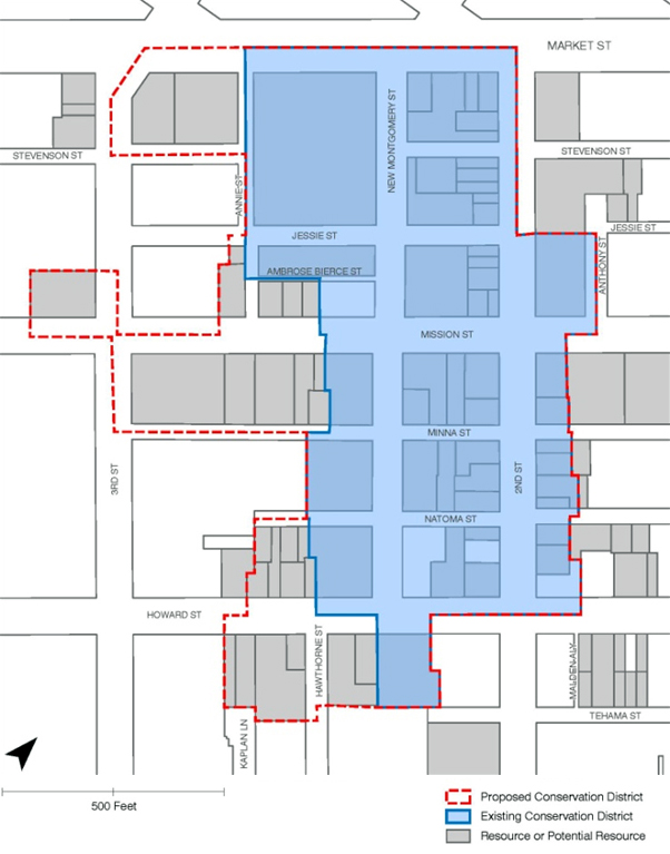
FIGURE 6 - Proposed and Existing New Montgomery Street, 2nd Street, and Mission Street Conservation District Boundary
The Plan recognizes that a number of existing buildings with architectural merit located within and adjacent to the existing Conservation District along Second, Howard, Natoma and Tehama Streets, have been previously identified for acquisition and removal by the TJPA in order to construct the Transit Center and Downtown Rail Extension (DTX). The removal of these historic resources has been vetted in adopted environmental documents. The overall historic integrity of the existing and proposed NMMS Conservation District remains intact, as do numerous associated adjacent groupings of buildings of merit in the immediate proximity. Moreover, while the City has no authority to restrict the TJPA’s demolition of buildings necessary to construct the Transit Center Project (including the DTX, ramps, etc.), new replacement buildings may be proposed on these parcels-to-be-acquired once construction of the train extension and Transit Center is complete. It is important that the design of new buildings on these sites be compatible, yet contemporary, with the adjacent district context in terms of massing, size, scale, and architectural features.
The survey identified a number of buildings that bear a strong association with San Francisco’s past and possess distinctive architectural characteristics. These irreplaceable buildings provide a tangible link to our history and the Planning Department will work with the community and stakeholders to identify and promote educational opportunities related to San Francisco history and historic preservation. Working with the community and stakeholders, the Planning Department will recommend to the HPC and the Board of Supervisors the nomination of individually eligible buildings for listing within Article 10 of the Planning Code as City Landmarks in order to protect, preserve, enhance and encourage continued utilization, rehabilitation and, where necessary, adaptive use of significant cultural resources.
OBJECTIVE 5.2
PROVIDE PRESERVATION INCENTIVES, GUIDANCE, AND LEADERSHIP WITHIN THE TRANSIT CENTER DISTRICT PLAN AREA
POLICY 5.5
Develop incentives that promote the retention and rehabilitation of significant resources within the Transit Center District Plan Area.
The Planning Department should continue to develop technical workshops, educational materials, and presentations for property owners and the public to increase the number of properties that take advantage of the Mills Act Property Tax Abatement Program.
Per the policies above, the Planning Department should evaluate and apply Article 11 classifications to all eligible buildings within the Plan Area so that property owners may leverage the sale of Transferable Development Rights (TDR) and other incentives for the maintenance and preservation of historic resources.
Transferable Development Rights (TDR)
In 1985 the Downtown Plan created the TDR program throughout the C-3 Districts. This program requires that, in order for the gross square footage of new development to exceed the established base Floor Area Ratio (FAR), the developer must purchase unused development rights from eligible historic properties in the downtown. The development rights for the historic property that sells TDR are forever retired and restrictions are recorded against the property. There are different C-3 sub-districts throughout downtown, with varying base FAR ranging from 5:1 to 9:1. The base FAR in the C-3-O(SD) district is 6:1 and in the C-3-O district it is 9:1. Currently, developments in both of these districts can build up to a maximum FAR of 18:1, meaning that projects building up to the maximum densities in these districts much purchase the square footage equivalent of 9 FAR or 12 FAR. For large projects, this can total several hundred thousand square feet of TDR.
When the TDR program was created through the Downtown Plan, the Planning Department at the time estimated that, based on its inventory of likely eligible historic properties, the potential “supply” of TDR was approximately 8 million square feet. Analysis of the remaining potential TDR has revealed that very few large, single sources of potential TDR (i.e. 50,000 gsf or larger) remain in the downtown. In other words, the large historic buildings in the downtown that can potentially sell large amounts of TDR have already sold their TDR, and generally only small properties remain to sell. The median size of potential TDR is currently less than 10,000 gross square feet. Considering that large projects individually need to assemble multiple hundreds of thousands of square feet each, this could mean that for each development someone would need to track down and assemble TDR from 20 to 30 historic properties.
There are many reasons why owners of historic properties have not and may not sell their potential TDR. These include: (1) they do not want to dilute their property rights; (2) the financial incentive is small in comparison to total property value; (3) they do not understand the TDR program; and (4) the organization of the ownership entity is unwieldy (e.g. family trust with many owners) and cannot or will not agree on a decision to sell the TDR.
Another concern is not just in the potential supply of TDR, but also in the imbalance between the likely potential supply and the likely demand. In the Transit Center District alone, there is the potential demand for over 7.5 million square feet of TDR given the proposed Plan rezoning, assuming the base FAR for the entire district is 6:1 and maintenance of the current rules requiring purchase of TDR for all square footage above the base. There is clearly not even half of the potential necessary TDR for that amount of demand. If the potential supply is too low, not only will developers not be able to find the TDR at any price, but the few sellers would be able to drive TDR prices to disproportionate heights. When the TDR program was created, economic analysis determined that the supply of TDR should be approximately two times the potential demand in order to have a healthy market.
POLICY 5.6
Maintain the TDR program as a critical component of the historic preservation program in the downtown and the Plan Area, but modify the program in the Plan Area based on updated information about the TDR program and on other objectives of this Plan.
POLICY 5.7
Balance the TDR requirement with other public benefits programs in the District by reducing the square footage requirement for the purchase of TDR by each individual development project.
POLICY 5.8
Pursue expansion of the supply of available TDR to meet expected demand or provide flexibility for development in satisfaction of the TDR requirement by providing an in-lieu mechanism that directly benefits the preservation, rehabilitation, maintenance and public education of historic resources in the downtown.
In order to ensure sufficient TDR continue to be available and to achieve the goals of the TDR program, the City should continue to investigate opportunities to expand the potential supply of TDR through designation of eligible buildings within and outside of the C-3, including publicly-owned historic properties that require substantial rehabilitation. A secondary approach after, or in tandem with, pursuing the expansion of supply would be the creation of an in-lieu TDR credit where project sponsors pay into a historic preservation fund.
OBJECTIVE 5.3
PROVIDE PRESERVATION INCENTIVES, GUIDANCE, AND LEADERSHIP WITHIN THE TRANSIT CENTER DISTRICT PLAN AREA
POLICY 5.9
Foster education and appreciation of historic and cultural resources within the Transit Center District Plan Area among business leaders, neighborhood groups, and the general public through outreach efforts.
In cooperation with the Arts Commission and the Department of Public Works develop a self-guided architectural and cultural tour, and infrastructure improvements, such as permanent markers in public spaces and along the public right-of-way, within the Transit Center District Plan Area.
OBJECTIVE 5.4
PROMOTE WELL-DESIGNED, CONTEMPORARY INFILL DEVELOPMENT WITHIN THE HISTORIC CORE OF THE TRANSIT CENTER DISTRICT PLAN AREA.
POLICY 5.10
Encourage well-designed, contemporary buildings for vacant sites, or to replace non-contributing buildings within the Conservation District that meet the Secretary of the Interior’s Standards.
POLICY 5.11
Provide technical assistance to government agencies and property owners for the development of buildings and amenities within the New Montgomery-Mission-Second Street Conservation District that strengthen its historic character and improve the public realm.
Several historic resources are proposed for demolition to construct the Transbay Transit Center. The Department should promote and encourage government agencies and other property owners to provide the City with well-designed, contemporary infill development within the New Montgomery-Mission-Second Street Conservation District, where applicable. New proposals for vacant land, whether devoted to the private or public realm, must strengthen the character-defining features of the District and contribute new opportunities for residents and visitors to experience and enjoy the District.
Infill projects must comply with Standard #9 of the Secretary of the Interior’s Standards, as well as any requirements of Articles 10 and/or 11 of the Planning Code, where applicable, and should represent the time in which they were constructed while respecting the character-defining materials, massing, size, scale, and architectural features of the District.
District Sustainability
Sustainability is inherent to the whole of the Transit Center District Plan, not least because of its location and focus as a regional transit hub. An overall aim for the Plan is to deliver low-impact, high-performing development that will fulfill regional growth and development requirements in an environmentally responsible and economically sound manner. The Plan capitalizes on the inherent land, energy, and water resource efficiencies of high-density, transit-oriented green development, thereby reducing the City and its residents’ dependency on these increasingly scarce and costly resources and providing a protective buffer against potential volatility in energy and water prices in the future. Though many positive impacts of the Plan will be felt locally by the city and the Bay Area region, it also achieves a global impact of helping to mitigate future impacts of climate change.
Regional Growth and Sustainability
From a regional sustainability perspective, there are substantial gains to be made with respect to the environmental impact of developing a high density regional transit hub located in the urban core of San Francisco as compared to continuing with the paradigm of lower-density suburban expansion. Aside from the land use program’s intensive transit-orientation, the proposed policies related to transportation management and public realm design described in the Public Realm and Moving About sections are necessary to realize the environmental gains represented in the model analysis. Included in these are comprehensive programs of re-allocating public right-of-way from space for autos (both parking and movement) to improve pedestrian conditions and to accommodate increased pedestrian travel, surface transit movement, and cycling, and of implementing core Transportation Demand Management policies related to congestion pricing, parking limitations, and enhancement of the function of the transportation brokerage services. All of these measures are necessary to achieve the core transit-oriented and non-auto goals of the Plan facilitate achievement of the carbon and resource reduction goals.
District Systems Sustainability
There are, however, some other significant opportunities that can be realized at a district level, particularly in terms of water usage, stormwater management, renewable resources, and energy efficiency, as well as green building practices. Due to the existing density of development in the Plan Area, mix of uses, and significant new development proposed, there is the opportunity for transforming the way the district uses energy. The redesign of the streets and public realm provides opportunities for a district-wide integrated water reuse management strategy that would substantially reduce use of potable water and have secondary benefits beyond minimizing flood risk. The focus on low energy buildings and efficient supply will ensure that properties in the Plan Area would lead the San Francisco real estate market in terms of low operating costs for both businesses and residents. Other sustainability opportunities to reduce the urban heat island effect, improve air quality, and enrich urban ecology are dealt with through inclusion of street trees, living walls, and other green infrastructure described in the Public Realm section.
District-Scale Energy and Combined Heat and Power
There is a great opportunity with the Transit Center Plan to establish a highly energy efficient district-scale approach to energy procurement and consumption, including combined heat and power (CHP), setting up the area to be an exemplar low carbon development. This will help the City to achieve its Climate Action Plan, Electricity Resource Plan and carbon reduction goals. With respect to CHP, the strategy could also future-proof the Plan Area to be able to take advantage of local renewable biomass energy sources as, and when, an appropriately scaled plant(s) becomes viable. Due to the high density of the development, the use of other forms of on-site renewable energy, such as building integrated solar power or urban-scale micro wind turbines, are unlikely to provide a significant proportion of energy demand in the near term. However, use of renewable generation and procurement of low-carbon energy are encouraged as part of an integrated district-scale energy strategy.
The greatest opportunity for reducing the energy use of buildings is energy-efficient building design, including passive and active control systems. However, a variety of approaches exist that may help reduce overall energy use and greenhouse gas emissions at a district scale, rather than the scale of individual buildings. These could include combined heat and power district energy facilities, use of the City’s existing steam loop infrastructure, procurement of GHG-free electricity, and other innovative methods to develop renewable energy at a community scale. For example, a trigeneration (tri-gen) system is a form of district energy that supplies electric power to a group of buildings while utilizing waste heat from power generation to also provide heating and cooling services to the district. By managing energy consumption at the community level, a networked approach can lead to greater overall efficiency, as well as lower and more stable energy costs. The bulk purchase of fuel and potential fuel flexibility can help mitigate the impact of a volatile fossil fuel marketplace (though most district heating networks and CHP systems currently run on fossil fuels). With a district heating systems, the district energy center can help future-proof an area for long term changes in fuel sources or technology advancements – only the energy center will need to be refurbished rather than each individual building should fuel cells or biomass gasifiers (or other new technology) become cost effective. Operation and maintenance tasks are also streamlined for building operators.
Areas characterized by high-density development with mixed uses providing complementary heat and power requirements, such as the Transit Center District Plan Area, may be good candidates for connection to a CHP system. The Plan Area and immediately adjacent areas (e.g. Transbay Redevelopment Area Zone 1, Rincon Hill, Central Corridor) contain commercial office space, retail, hotel, and residential uses and are surrounded by further areas of proposed development with potential for future expansion of any system started within the Plan Area.
Existing sources of waste heat, either from local underutilized plant or industrial processes can also be linked into district systems, further improving efficiency and reducing cost. This heat can essentially be considered zero carbon. The heat loads of existing and proposed new buildings in the Transit District are being assessed to help the City understand the opportunity to a greater extent. A number of buildings in the local area have invested in their own CHP plants to provide long term energy efficient heat and power supply, which may have the potential to supply adjacent buildings. Locally generated electricity supply can also help reduce peak loads on grids, and therefore, help minimize brownouts and reduce the need for investment in new more expensive, large scale plant and distribution systems.
OBJECTIVE 6.1
INCREASE ENERGY EFFICIENCY, REDUCE CARBON-INTENSIVENESS OF ENERGY PRODUCTION, AND ENHANCE ENERGY RELIABILITY IN THE DISTRICT.
OBJECTIVE 6.2
CAPITALIZE ON THE BALANCED, DENSE, MIXED-USE DEVELOPMENT IN THE TRANSIT CENTER DISTRICT AND TRANSBAY REDEVELOPMENT AREAS TO ENACT DISTRICT-SCALE ENERGY MEASURES.
OBJECTIVE 6.3
STREAMLINE POTENTIAL IMPLEMENTATION OF A DISTRICT ENERGY DISTRIBUTION NETWORK BY PHASING MAJOR STREETSCAPE AND UTILITY WORKS IN LINE WITH NEW BUILDING DEVELOPMENT IN THE TRANSIT CENTER DISTRICT AND TRANSBAY REDEVELOPMENT AREA.
POLICY 6.1
Pursue creation of efficient, shared district-scale energy systems in the district.
POLICY 6.2
Pursue a combined heat and power (CHP) system or series of systems for the Transit Center District and the Transbay Redevelopment Area (Zone 1).
POLICY 6.3
Require all new buildings to be designed to plug into such a system in the future.
POLICY 6.4
Require all buildings undergoing major refurbishment (defined as requiring new HVAC plant) to be designed to plug into such a system in the future.
POLICY 6.5
Identify and protect either suitable public sites or major development sites within the plan area for locating renewable or CHP generation facilities.
POLICY 6.6
Require all major development to demonstrate that proposed heating and cooling systems have been designed in accordance with the following order of diminishing preference:
- Connection to sources of waste heat or underutilized boiler or CHP plant within the transit center district or adjacent areas
- Connection to existing district heating, cooling, and/or power plant or distribution networks with excess capacity
- Site-wide CHP powered by renewable energy
- Site-wide CHP powered by natural gas
- Building level communal heating and cooling powered by renewable energy
- Building level communal heating and cooling powered by natural gas
POLICY 6.7
Investigate City support for energy service companies to finance, build, operate, and maintain transit center district energy networks; and work with necessary private utilities to facilitate connection of new electricity supply from CHP to the grid.
POLICY 6.8
Require all major development in the plan area to produce a detailed energy strategy document outlining how the design minimizes use of fossil fuel driven heating, cooling and power—through energy efficiency, efficient supply, and no or low carbon generation.
In addition to the LEED or Greenpoint rated checklist, each development should be expected to produce a detailed energy strategy document outlining how the design of the building minimizes its use of fossil fuel driven heating, cooling and power—through energy efficiency, efficient supply and no or low carbon generation. The city should develop a template strategy document outlining the information required as guidance for developers.
Building Performance
OBJECTIVE 6.4
ENSURE THAT NEW BUILDINGS CONSTRUCTED IN THE PLAN AREA REPRESENT LEADING EDGE DESIGN IN TERMS OF SUSTAINABILITY, BOTH HIGH PERFORMANCE FOR THEIR INHABITANTS AND LOW IMPACT ON THE ENVIRONMENT.
POLICY 6.9
Encourage buildings to take maximum advantage of San Francisco’s moderate year-round climate through integration of passive solar features into building design.
POLICY 6.10
Encourage the use of natural ventilation to reduce the need for mechanical air conditioning.
POLICY 6.11
Use renewable energy systems to reduce the use of fossil fuel generated energy.
While providing on-site renewably generated power can be challenging in highly dense urban areas, and particularly for high-rise buildings, an assessment of the feasibility of integrating renewable energy technologies into building design should be undertaken for review by the city. Other methods of obtaining renewable or GHG-free electricity include district-scale approaches to renewable generation or procurement of electricity from a GHG-free provider.
POLICY 6.12
Consider requiring all major buildings in the Plan Area to achieve the minimum LEED levels established in the SF Green Building Ordinance excluding credits for the given inherent factors of location, density, and existing City parking controls, in order to achieve high-performance buildings.
There are certain credits within the LEED scheme such as proximity to public transit and local amenities that new buildings in the Plan Area will automatically achieve due to their location. In addition, there are existing progressive City policies that new buildings will have to comply with which will also achieve LEED credits by default without requiring a further improvement in their design. Therefore, new development within the Plan Area may otherwise be able to achieve the minimum required certification levels on these virtues without substantive improvement to the core performance of the building itself. Implementation of this policy would require all projects within the Plan Area to exceed the minimum number of points needed to achieve the required certification level and require project sponsors to focus efforts on improving the actual environmental performance of the buildings and sites themselves, including energy, water, and materials.
POLICY 6.13
All major buildings in the Plan Area should exceed the minimum credits required by the SF Green Building Ordinance under the Energy and Water categories of the LEED schemes.
In order for new development within the Transit Center District to help achieve pivotal goals relating to carbon dioxide emission reduction, to help address California’s water shortages, and to position the Plan Area as an exemplar of sustainable development, it is important that energy and water efficiency are prioritized when developers are considering how to achieve the required LEED certification.
The relevant sections of the San Francisco Building Code relating to the Green Building requirements would need to be amended to reflect these policies for the Plan Area.
District Water
Water Supply
The city’s water is supplied by the SFPUC’s Regional Water System. The Hetch Hetchy Reservoir in Yosemite National Park delivers pristine Sierra snowmelt to provide 85 percent of San Francisco’s water, and local protected Alameda and Peninsula sources provide the remaining 15 percent. Currently, this high-quality potable water is used for almost all purposes, including those that do not require potable water, such as irrigation, toilet flushing, and industrial uses. There are many critical and ever-increasing reasons for the City to reduce the overall amount of potable water we use and increase the efficiency with which we use water in order to ensure continued reliable and adequate potable water for necessary potable uses. These reasons include frequent droughts, climate change, projected local and regional growth, impacts to fish and other wildlife, and environmental concerns for the health of the ecosystems from which the water is drawn. Developing a local supply of non-potable water for non-potable uses will help ensure that our water supply portfolio is managed to provide a reliable, high quality supply for public drinking water and ensure the state’s environment is not compromised.
Wastewater
Most of San Francisco (including the Transit Center District) is served by a combined storm sewer system, where stormwater, along with residential and commercial sewage, is directed to treatment plants prior to being released to the San Francisco Bay or the Pacific Ocean. During major wet weather events, stormwater runoff can overwhelm treatments plants that treat the combined sewers, leading to untreated or partially treated discharges into the Bay and Ocean. In addition to pollution and health problems, high amounts of runoff into the sewer systems can overwhelm them and lead to localized flooding. In urbanized areas, like the Transit Center District Plan Area, a high percentage of impervious surfaces (e.g. roofs, streets) leads to very high volumes and velocities of stormwater entering the sewer system during wet weather, contributing substantially to these problems. These problems can be addressed by both reducing the amount of water discharged into the combined sewer system (such as by graywater re-use) and by slowing or storing stormwater when it hits the ground or structures.
Recycled Water
Municipal recycled or other non-potable water use is a major avenue of future water efficiency and promises substantial reduction in potable water use. Non-potable water can be used for toilet flushing, building boilers/chillers, irrigation, and other uses. The Plan area is within the City’s designated Recycled Water Use Area (Use Area). The Recycled Water Ordinance, adopted in 1991, requires large developments in the Use Areas to be dual-plumbed (with “purple pipes”) to use recycled water once hookup is available to a recycled water distribution system. Currently there are no treatment facilities available to supply recycled water to the Transit Center District. The dozens of major new commercial and residential buildings that are approved or proposed in this area, representing over 6 million square feet of new office space and over 5,000 new housing units provide a great opportunity to advance the objectives and infrastructure for non-potable water use in the Ordinance area.
Storm and Rainwater Harvesting
Harvesting of stormwater runoff and rainwater during the rainy season for use is a time-honored tradition in arid and Mediterranean climates around the world, and is a logical way to remove large volumes of water from combined sewers. Because it does not contain sewage, if properly captured, this stormwater can receive moderate treatment and be reused for irrigation and other non-potable purposes such as toilet flushing and cooling. San Francisco agencies have agreed to allow the collection and use of rainwater for irrigation,toilet flushing, and other approved non-potable uses with moderate treatment. Rainwater and stormwater harvesting will have a two-fold impact on the system by providing a local source of water and reducing the demands on the combined sewer system.
Dewatering System Diversions
Another source of non-potable water is foundation drainage water. Throughout the downtown core, it is not uncommon for large buildings with foundations located below the water table to extract groundwater (through dewatering operations) which would otherwise seep into the foundations. This water is disposed of year-round to the combined sewer system where they contribute to pumping costs and combined sewer overflows. The City could require that all new buildings that dewater must develop re-use opportunities for this water for non-potable purposes, and could explore such re-use opportunities for existing buildings that are dewatering as well. One example is the Powell Bart station where preliminary studies indicate that the dewatering system discharges approximately 167,900 to 180,700gallons of groundwater to the sewer per day. Harvesting this water could result in approximately 65 million gallons of water annually. This is one example of numerous buildings within the area where foundation drainage resulting from high groundwater that could serve as another source of non-potable water for the city.
OBJECTIVE 6.5
REDUCE THE AMOUNT OF POTABLE WATER USED IN NEW DEVELOPMENT IN THE DISTRICT.
OBJECTIVE 6.6
REDUCE STORMWATER RUNOFF FROM THE DISTRICT INTO THE SEWER SYSTEM TO IMPROVE BAY WATER QUALITY AND REDUCE STRAIN ON TREATMENT PLANTS DURING WET WEATHER EVENTS.
OBJECTIVE 6.7
TAKE ADVANTAGE OF SIGNIFICANT CONCENTRATED DEVELOPMENT AND INFRASTRUCTURE RECONSTRUCTION IN THE DISTRICT AND ADJACENT AREAS TO CREATE DISTRICT-SCALE WATER EFFICIENCY AND REUSE MEASURES.
POLICY 6.14
Create a reliable supply of non-potable water that can be used throughout the plan area to reduce potable water demand.
POLICY 6.15
Pursue a variety of potential sources of non-potable water, including municipally-supplied recycled water and district-based graywater, black water, stormwater, and foundation drainage water.
POLICY 6.16
Create infrastructure in the Transit Center District and immediately adjacent areas for non-potable water use, including treatment and distribution.
POLICY 6.17
Include distribution pipes and other necessary infrastructure for non-potable water when undertaking any major streetscape or other infrastructure work in the right-of-ways in the Transit Center District and immediately vicinity.
POLICY 6.14
Identify and protect suitable sites within the Plan Area or immediate vicinity for locating a treatment facility for creating a local nonpotable supply.
The two options for creating a treatment and supply facility for the Transit Center District and adjacent areas are:
-
Add recycled water capacity at the existing North Point or Southeast Wastewater plants, per the suggestion of the RWMP, or at a new site to serve the entire eastside recycled water use area; or
-
Create a local district-serving treatment facility in the Transit Center District. A local district-serving treatment facility could be created by diverting some amount of flow in the combined sewer system in the Transit Center District into a local plant, or by acquiring area-generated excess stormwater, graywater, blackwater, and foundation drainage that cannot be used on-site by individual buildings before they enter the municipal wastewater system.
Such a local facility could be located below ground or above ground. Potential sites should be identified in the area, and could include underneath the future Transbay Square park in Zone 1 of the Redevelopment Area (block bounded by Howard, Main, Folsom, and Beale), above ground underneath the bus or freeway ramps, or integrated into one of the major development sites.
Because such extensive streetscape and infrastructure work will be done in coordination with the Transit Center, Downtown Extension (DTX), and development projects in the Transit Center District and Transbay Redevelopment Area, the opportunity to create the necessary non-potable water distribution system at marginal additional cost should not be missed. The cost of implementing a district-serving non-potable water distribution system later on would be substantially more. Even if a local recycled water treatment facility is not created in the immediate area and the SFPUC proceeds at a later date with adding this function to a more distanced plant, it is essential to advance the use of non-potable water by coordinating with any and all major streetscape and infrastructure work to create the necessary future distribution system.
POLICY 6.19
All new and large redevelopment projects in the city should adhere to the following hierarchical approach to maximize resources and minimize use of potable water:
- Reduce demands by installing efficient water fixtures and behaviors;
- Identify all on-site sources (rainwater, cooling tower blow down, fog, graywater, blackwater, stormwater, and foundation drainage water);
- Install appropriate on-site collection, treatment, storage and conveyance systems for toilet flushing, irrigation and additional identified nonpotable applications;
- Meet surplus non-potable demands using district non-potable water or municipal recycled water; and
- Meet all other remaining demands using potable water.
POLICY 6.20
Ensure projects use Low Impact Design (L.I.D.) techniques in all streetscape, public space, and development projects to reduce the quantity of stormwater runoff and slow its flow into the sewer system, and to harvest this water for on-site uses.
Funding Public Improvements
A key goal of this Plan is to create a very high-density, mixed-use urban neighborhood that capitalizes on and supports the major transportation investment and service represented by the Transbay Transit Center. Once the Plan, which proposes to allow significant density and height above the current zoning, is realized, new residents, workers, and visitors drawn to the area will create significant new demand for infrastructure and services which the area’s dated infrastructure and services cannot meet. While new development will generate a variety of local public revenues (property taxes, sales taxes, real estate transfer taxes, etc.), additional investments in parks, streets, transportation facilities, and community facilities and services—beyond what can be provided through these local General Fund revenue sources—are essential to meet demand attributable to the new development. To address the impacts of the new development, the Plan includes mechanisms for development to contribute to the funding of public infrastructure.
Plan Public Infrastructure Program
To achieve the Plan’s objectives and create the district envisioned, a broad range of public improvements and related programs are needed, as described in the prior sections. New residents, workers, and visitors drawn to new development in the Plan Area will increase demands on the existing transportation and transit network, open space and public facilities in the Plan Area and create demand for new infrastructure. In summary, four broad categories of public improvements are needed:
-
Streets and Pedestrian Circulation – including district-wide streetscape and pedestrian improvements, extensive widening of sidewalks, mid-block street crossings, signalization improvements, casual carpool waiting area improvements, landscaping and enhanced pedestrian routes from the Transit Center to nearby destinations and transit services.
-
Transit and Other Transportation – including improvements to enhance transit operational effectiveness, capacity, enhance safety, reduce congestion, manage transportation demand, and provide better connections to local and regional transit systems.
-
Open Space – including new parks, public plazas, recreational amenities, and green infrastructure throughout the Plan Area.
-
Sustainable Resource District Utility – district-wide systems for non-potable water and for combined heating and power that will serve development in the Plan Area and reduce environmental and infrastructure pressures of growth.
The Transit Center District Plan Program Implementation Document provides a detailed list of these improvements and programs identified throughout this Plan as well as their preliminary cost estimates. The Transit Center District Plan includes many necessary improvements to public infrastructure, services, and programs to support additional development. The focal point of the Plan area is realizing the improved multi-modal Transbay Transit Center. The former Transbay Terminal was a blighted and outdated facility. Because alleviating blight and creating new transit facilities adds substantial value to nearby real estate and facilitates higher density development than may otherwise be achievable, the Plan incorporates zoning changes that increase overall densities in the Plan Area. This higher density development can generate various sources of revenue that can then be used to offset the costs of the public improvements that have enabled the increased densities and values. However, it is important to balance the need for development-based revenues for public improvements with the economics of private development to enable the desired development to be financially feasible.
The policies and discussion below seek to establish parameters for private development’s contributions to the costs of the public improvements, given financial feasibility.
OBJECTIVE 7.1
ENSURE THAT PRIVATE DEVELOPMENT CONTRIBUTES FINANCIALLY TO BUILDING ESSENTIAL PUBLIC IMPROVEMENTS IN PROPORTION TO THE IMPACT THAT SUCH NEW DEVELOPMENT GENERATES IN THE DISTRICT.
OBJECTIVE 7.2
GENERATE PRIVATE DEVELOPMENT FUNDING TO HELP COMPLETE THE TRANSBAY TRANSIT CENTER PROJECT AND TO ESTABLISH A SUSTAINABLE RESOURCE PROGRAM WITHIN THE DISTRICT.
OBJECTIVE 7.3
BALANCE THE COST TO BE PAID BY PRIVATE PROJECTS FOR PUBLIC IMPROVEMENTS IN THE DISTRICT WITH THE ECONOMIC FEASIBILITY OF THESE DEVELOPMENTS.
POLICY 7.1
Require new development to participate in applicable components of a Funding Program as a condition of approval.
POLICY 7.2
Require that new development continue to be subject to existing impact fee programs and inclusionary housing requirements.
POLICY 7.3
Create a community facilities district to fund capital improvements, particularly the Transit Center, as well as operations and maintenance of new public spaces and facilities.
POLICY 7.4
Require all new development to pay development impact fees to fund implementation of the public improvements plan, proportional to the impact generated by new development.
POLICY 7.5
Within the limits of the established nexus for new fees, create tiers of the new impact fee to assess higher fees for more intensive projects where economically feasible.
POLICY 7.6
Provide flexibility for developers to meet Funding Program obligations through one-time charges, ongoing revenue streams, or in-kind contributions.
POLICY 7.7
Seek additional funding sources for necessary or desirable public improvements that are not funded by the Funding Program and existing fees and requirements.
POLICY 7.8
Create a Transit Center District Plan Program Implementation Document that outlines the Funding Program and guides future decision making in allocating revenues to public improvements.
Transit Center District Sub-Area Plan adopted by Board of Supervisors Ordinance 0185-12 on 07/31/2012.
Amendments by Board of Supervisors Ordinance 0042-25 adopted on 03/25/2025.