Glen Park Community Plan
INTRODUCTION
The Glen Park Community Plan is not a redevelopment plan or a plan proposing major change. The primary intent of the Plan is to preserve and enhance the unique qualities and character that make Glen Park special. The focus of the Plan is the “village” or “downtown” Glen Park – the small cherished but challenged neighborhood center and source of great community pride.
In 2002, a series of intensive planning workshops took place with residents, merchants and public agencies to create a preliminary plan for Glen Park. After publication of the Draft Glen Park Community Plan (2003)1, the project was postponed until additional funding could be identified to carry the Plan forward.
In 2009, the Planning Department and San Francisco Municipal Transportation Agency (SFMTA) re-launched the community planning process to revise and refine the draft Plan. The document here synthesizes the earlier planning effort with a series of public workshops and discussions held with the Glen Park community from 2009 - 2011.
1. Draft Glen Park Community Plan Summary (2003), Planning Department
Figure 1: Glen Park Timeline
Glen Park’s Unique Character
Glen Park exudes a small town charm unique within San Francisco. Nestled in a valley, the neighborhood sits amidst the natural beauty and steep topography of Glen Canyon. Winding streets, stunning views and a human-scaled built environment create a “village” atmosphere. At the same time, specialty stores, restaurants and transportation options provide conveniences found only in a big city. Glen Park uniquely combines the best features of a dense urban neighborhood with the characteristics of a small town.
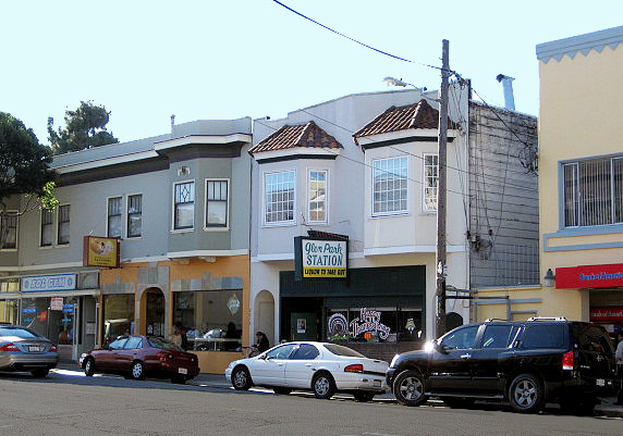
The “Village” Center
The heart of Glen Park is what residents commonly refer to as the “village” or “downtown.” This area encompasses the neighborhood commercial district along Diamond and Chenery Streets and nearby BART station. Here streets are lined with popular shops and restaurants - many of them locally-owned. Neighbors meet while visiting the library, markets or cafes. The confluence of BART and Muni transit lines makes downtown Glen Park a major intermodal transit center for the neighborhood and region. Over 9,000 riders use the Glen Park BART station every day. Approximately 75% of them arrive at the station by walking or public transit (Figure 2). In addition, the area provides direct and easy access to the I-280 freeway.
Figure 2: Glen Park Bart Station - Mode of Arrival. Source: Glen Park Community Plan Environmental Impact Analysis & Transportation Feasibility Study (2010)
Glen Park is a highly walkable and transit friendly area. Over half of the transit riders using the Glen Park BART Station area arrive by walking.
Key Challenges & Issues
Preserving Glen Park’s Character
Glen Park’s function and cherished qualities face some key challenges. Addressing these issues and protecting the character of the community are goals of the Glen Park Community Plan.
Transportation and Circulation
Glen Park’s small downtown sits at the center of a major transportation interchange. Several bus lines, freeway on/off-ramps and the BART station all converge here. Consequently, the area is a magnet for commuters inside and outside the neighborhood. Few entry and exit points and the limited capacity of narrow streets contribute to rush hour congestion, parking anxieties and concerns for pedestrian safety. Glen Park’s topography and fine-grained street grid strain to handle all of this activity. These transportation and circulation conflicts threaten the “village” quality residents wish to protect.
Mega Infrastructure
Massive public infrastructure projects of the 1960s and 70s significantly altered Glen Park. The freeway building boom resulted in the construction of the I-280 freeway, widening of Bosworth Street and the freeway-like portion of San Jose Avenue. These projects made vehicle access to and through Glen Park more convenient. However, they also severed connections to surrounding neighborhoods, brought new levels of traffic and introduced infrastructure out of scale with the small community. The opening of the BART station in 1973 further transformed Glen Park into a regional transit stop drawing thousands of riders into the neighborhood each day. Opportunities exist to more carefully stitch these large infrastructure projects back into the fabric of Glen Park.
Development Concerns
Glen Park is a largely built-out neighborhood and will not experience massive new growth or development. Only a limited number of sites for future development exist in the commercial core. These include the parcels at the northwest corner of Diamond and Bosworth Streets and the BART parking lot. The prominence of these sites requires they receive a high level of attention to ensure any development proposals support the context and character of the village.
The Community Plan
The Community Plan provides a vision for Glen Park developed in collaboration with the community from 2002-2011. The Plan seeks to protect and reinforce the character of the neighborhood commercial district, resolve challenges caused by the area’s massive vehicle infrastructure, enhance pedestrian and transit movement, improve the area’s mix of open spaces, and restore connections to Glen Canyon Park and surrounding neighborhoods.
The Plan will become part of the City’s General Plan providing long-term guidance to decision makers and public agencies to ensure infrastructure and land use changes are carried out with special sensitivity to the neighborhood. The Plan directs the City to implement certain near-term projects as well as pursue a couple of larger future visions.
The following chapters contain a set of objectives and policies in the areas of Land Use & Urban Design, Transportation, and Open Space. A corresponding implementation program follows detailing how the Plan will be carried out over time.
The Community Plan’s boundary includes Glen Park’s neighborhood commercial district, BART station, nearby homes, streets and open space.
The Glen Park Community Plan strives to achieve the following goals:
-
Protect and strengthen the character of Glen Park’s vibrant walkable neighborhood commercial district.
-
Balance the use of streets for pedestrians, bicycles, transit and automobiles in a way that satisfies circulation needs and enhances the livability of Glen Park.
-
Minimize the negative impacts of past large-scale infrastructure projects on the community.
An Evolving Village
Glen Park has grown from an area of disparate homesteads and cattle pastures into a thriving urban neighborhood. The images below illustrate the growth and change of the Glen Park village and surrounding area over the last 100 years.
1915
By 1915, Glen Park’s transformation from ranchland to neighborhood was well underway. The introduction of streetcar service (1892) to downtown San Francisco made the area more desirable for residential development. The map above shows land subdivided into lots with a scattering of homes and businesses. A cluster of buildings at Diamond and Chenery Streets demarcates a growing commercial district.
1946
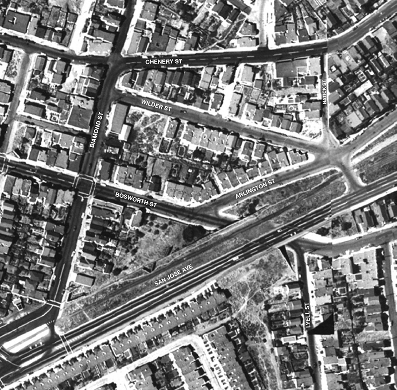
This aerial photo shows Glen Park village and the surrounding neighborhood largely built out. While the railroad tracks still exist, the train’s path has been widened to accommodate a four-lane San Jose Avenue. A large residential development can be seen just south of San Jose Avenue that would be removed just a few years later.
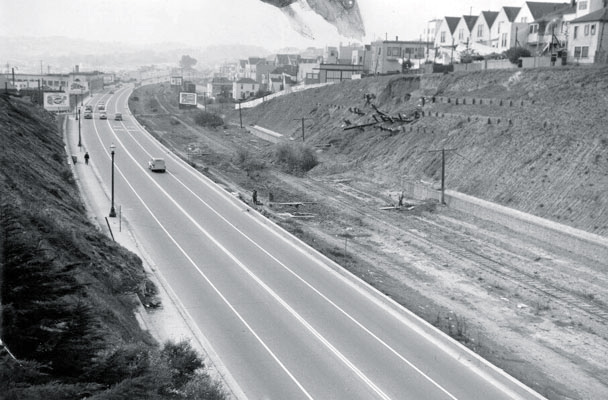
1964
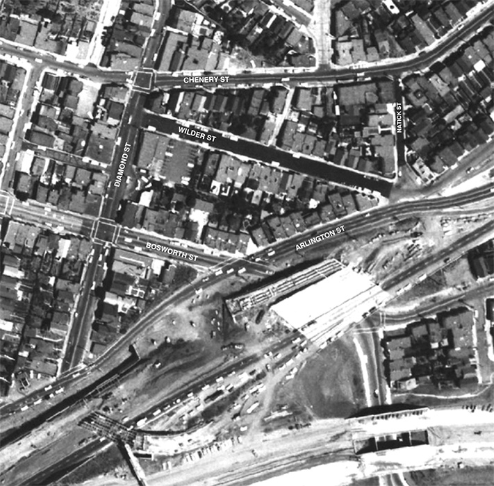
The construction of the Southern Freeway (I-280) and reconfiguration of San Jose Avenue are captured in this dramatic photo. The massive new vehicle infrastructure can be seen encroaching on the Glen Park neighborhood.
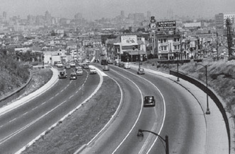
2011
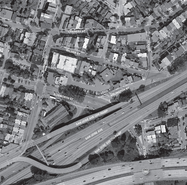
Here is the Glen Park of today. The popular village center is bordered by a tangle of roadways and on/off ramps. A number of homes and part of the commercial district have been removed to make room for the BART Station (1973) and parking lot. Extended in 1991, Muni’s J-Church line runs down the middle of San Jose Avenue.
Land Use & Urban Design
San Francisco’s neighborhood commercial districts serve an important role in the city. They offer a range of goods and services, shape community identity, and provide public gathering places. Glen Park’s commercial district emerged in the 1890s-1920s prior to the automobile boom. Built around pedestrians and public transit, the district’s intimate scale and rows of shops create a “village” atmosphere residents love.
The success and vibrancy of the commercial district is a product of its compact form, abundant transit service (BART & Muni) and dense mix of uses.
Within just a few blocks one can find restaurants, cafes, banks, salons, a grocery store, library and more. This concentration of activity supports a vibrant street life and leads to a feeling of safety on the streets. In contrast to the nearby freeway interchange, the village’s human-scale gives the area an intimacy and special charm.
The Plan seeks to guard and capitalize on the rare synergy afforded by the commercial district’s proximity to the BART station and surrounding homes to enhance walkability, safety, commercial vitality and community identity.
OBJECTIVE 1
PROTECT AND STRENGTHEN THE QUALITIES THAT MAKE DOWNTOWN GLEN PARK SPECIAL
The success of Glen Park’s commercial district is strongly linked to its diversity of uses, proximity to BART and surrounding residential areas. Its essential strengths should be preserved and expanded upon.
POLICY 1.1
Concentrate commercial uses and retail activity along Diamond and Chenery Streets to reinforce these as contiguous retail streets.
Glen Park’s thriving commercial core is a key component of the neighborhood’s character. Its function and vitality should be strengthened by maintaining a continuous pedestrian and retail frontage along these important streets.
POLICY 1.2
Update existing neighborhood zoning to strengthen Glen Park’s commercial district and reinforce the area’s pedestrian and transitoriented character.
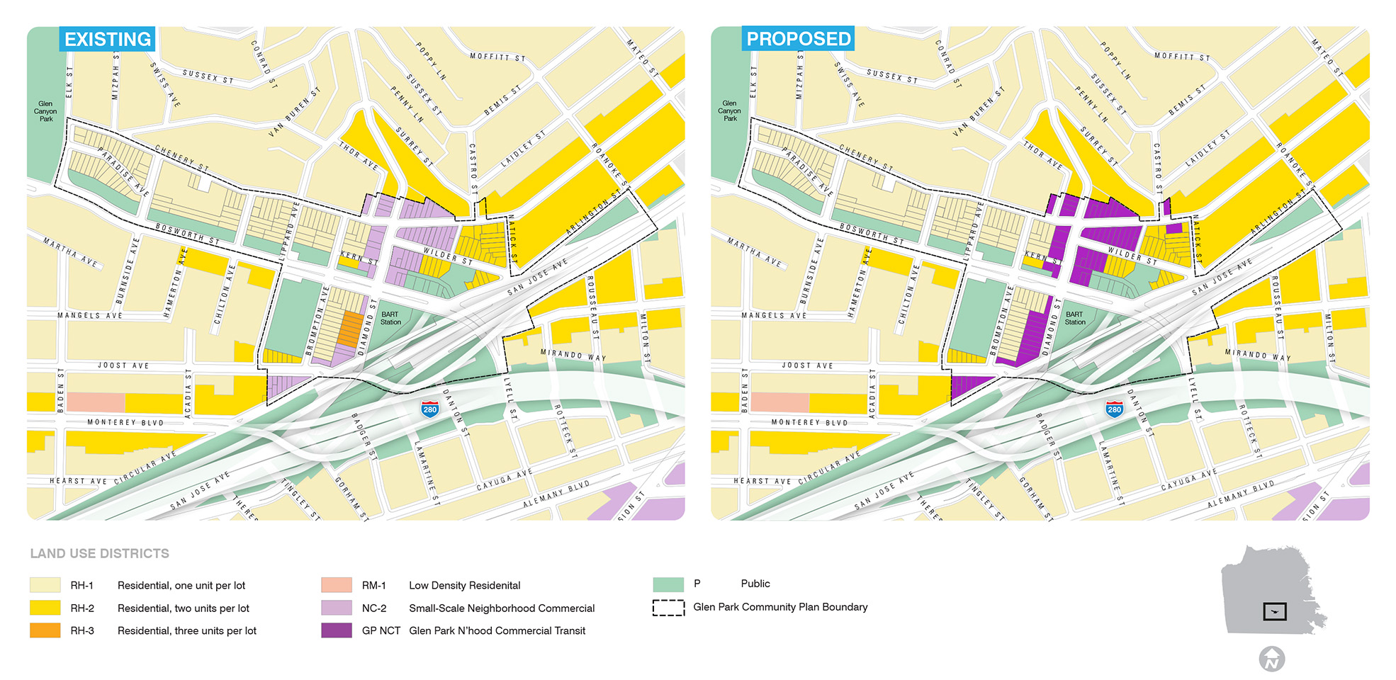
The Planning Department has worked with communities to apply Neighborhood Commercial Transit (NCT) zoning districts to strengthen San Francisco’s most walkable, transit-served, neighborhoods. The Plan proposes creating a unique Glen Park Neighborhood Commercial Transit District (see below for description).
A Glen Park Neighborhood Commercial Transit District
Creation of the Glen Park Neighborhood Commercial Transit District (Glen Park NCT) includes the following components:
-
Five foot height bonus for taller ground floors in commercial area. This slight height allowance is designed to encourage taller, roomier, commercial groundfloor storefronts that more closely reflect the district’s historic building pattern and support an inviting pedestrian environment. The increase, however, does not allow for an additional floor of development.
-
Flexibility in housing density and parking limits. In some cases, housing or commercial uses may be allowed with reduced off-street parking requirements to mirror the historic building pattern and support walkability, transit use and the efficient use of limited building space. Density would be determined by building height, bedroom count, design considerations and building codes.
-
Street frontage requirements along Diamond and Chenery Streets (within commercial district only). Glen Park’s compact commercial district and continuous rows of storefronts create and an attractive, popular, pedestrian-friendly shopping area. To preserve this character, zoning adjustments should:
- Require commercial uses at ground floors.
- Prohibit new curb cuts and driveways to safeguard the pedestrian experience and encourage retail activity.
- Require new off-street parking to be set back from the street to limit visibility and allow active uses.
Glen Park’s neighborhood commercial district is located primarily along Diamond and Chenery Streets. The district is currently zoned NC-2 (Small-scale Neighborhood Commercial) which allows commercial uses on lower floors of buildings and residences or offices above.
POLICY 1.3
Recognize the historic commercial pattern of the neighborhood by including existing Limited Commercial Uses (LCUs) into the neighborhood commercial district.
A small number of commercial uses exist in Glen Park that are not technically zoned for commercial activity. These popular businesses contribute to the vitality of the commercial district but are not formally recognized as part of it. Incorporating these properties into the neighborhood commercial district will ensure their important contributions to the area are preserved.
POLICY 1.4
Improve the streetscape in the commercial core to make the area safer and more comfortable for pedestrians and shoppers.
The sidewalks in Glen Park’s commercial core, particularly on Diamond Street, are narrow, cluttered and congested during peak times with few places to stop, sit or people watch. Opportunities to create additional gathering space should be sought. Consolidation of newsracks, undergrounding of utilities, sidewalk widening and other pedestrian improvements should be pursued.
POLICY 1.5
In the interior of Glen Park village, buildings should reinforce the existing character of the neighborhood.
The interior of Glen Park village is characterized by smaller buildings. This fine-grained pattern helps create an intimacy and a comfortable pedestrian environment.
Zoning
What is proposed to change?
The Plan recommends updating the existing neighborhood commercial zoning (NC-2) with a Glen Park neighborhood Commercial Transit District (Glen Park NCT). This new zoning recognizes the neighborhood’s unique identity, historic building pattern, and pedestrian/transit orientation. It includes the following components:
- Height bonus (5’) to allow taller ground floor storefronts but not another story of developement.
- Flexibility related to housing density and parking limits.
- Street frontage requirements: ground floor active uses, curb cut restrictions and setbacks for off-street parking.
What is not changing?
no changes are proposed for the publicly zoned (P) parcels including the BART properties. Residential zoning will also predominantly remain intact except for changes described in box below.
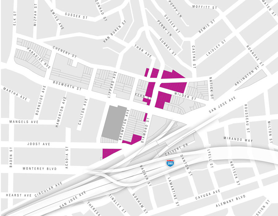
Additions to Glen Park’s Commercial District
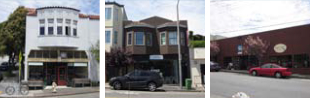
Left: Destinations Bakery 3121-3125 Castro Strett; Center: Osha Thai 2922-24 Diamond Street; Right: East-West Medicine 605 Chenery Street
Three residentially zoned properties with existing commercial uses are proposed for addition to the Glen Park neighborhood Commercial Transit District. The zoning change formally recognizes these properties as part of Glen Park’s commercial district.
2928-2958 Diamond Street
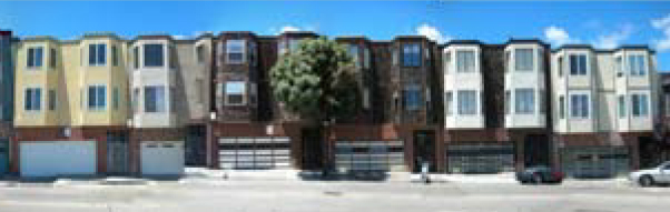
Located across from the BART station, this row of residential (RH-3) apartment buildings froms a gap in the commercial district. Rezoning of these properties to Glen Park nCT allows for possible ground floor commercial uses at a future time.
Heights
OBJECTIVE 2
ENSURE THE COMPATIBILITY OF NEW DEVELOPMENT WITH THE FORM AND CHARACTER OF GLEN PARK
Although little future growth is expected in Glen Park, new development should be sensitive to the area’s existing scale and reflect the mix of housing and commercial uses found there.
POLICY 2.1
Involve the community in decisions affecting Glen Park’s built environment.
The community’s strong interest and concern for neighborhood changes requires that outreach to residents be a part of any significant proposal for development in downtown Glen Park.
POLICY 2.2
Consider new housing and commercial opportunities in appropriately scaled infill development that supports the commercial area.
The vibrancy and safety of downtown Glen Park depends on a certain intensity and concentration of activity. The addition of appropriately scaled and designed housing or small-scale retail should be considered to reinforce the established pattern. Two potential locations where this type of development may be possible and beneficial include the cluster of parcels at the northwest corner of Diamond and Bosworth Streets and the BART parking lot. Any development on sites in the village should include wide sidewalks, where compatible with existing sidewalk patterns on adjacent frontages.
Which is more appropriate for Glen Park’s commercial area?
The Plan aims to reinforce the qualities that make the village successful including pedestrian character, active storefronts and visual interest.
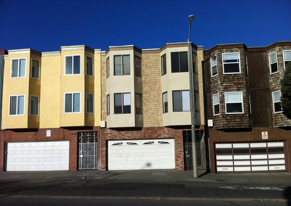
Garages and vehicle entrances disrupt the commercial district’s flow of storefronts, introduce conflicts with pedestrians, remove on-street parking spaces, and generally create an uninviting street environment.
The district’s charm and function is largely created by the pattern of varied building types. Groundfloor shops and windows allow views of the activity inside.
POLICY 2.3
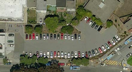
Consider other possible uses for the BART parking lot.
Glen Park’s 54-space BART surface parking lot provides free parking for BART patrons but contributes little to the character of the surrounding area. Given its central commercial district location and proximity to transit, a mix of commercial and residential uses here would contribute more to neighborhood vitality. BART has expressed interest in exploring development on this site. If pursued, a focused community process to determine what the appropriate form and character for new development should take place between BART, the Glen Park community and the City.
BART Parking Lot
No zoning change for property owned by BART is recommended as part of this Plan. Currently, the lot is zoned for Public use allowing only public-serving infrastructure or facilities. Housing or commercial buildings are not permitted at this time.
The Plan recognizes other uses might be preferable to a surface parking lot and should be explored. BART is considering the feasibility of developing the lot and is committed to involving the community in the process. Future rezoning consideration or project proposals should be in response to such a public process. All future zoning or development proposals would be subject to public hearings and approvals by the Planning Commission and Board of Supervisors.
POLICY 2.4
Design of new buildings should be consistent with the neighborhood’s existing pattern.
New buildings or major renovations should reinforce the character of Glen Park by creating attractive, pedestrian-friendly places to live, visit and shop. Infill development should follow existing design guidelines and be consistent with the intent and policies of the Plan particularly in relation to scale, height, bulk, materials and details.
Proposed development should relate to neighborhood character. Setbacks of facades may be appropriate to avoid an overwhelming appearance of new structures. Human-scaled buildings should be designed to be built close to the sidewalk, have active ground floors, use high-quality materials, and contain interesting features. Long blank monotonous walls or highly visible parking entrances should be avoided.
OBJECTIVE 3
RECOGNIZE THE CONTRIBUTION OF HISTORIC BUILDINGS TO NEIGHBORHOOD IDENTITY
Some of Glen Park’s earliest buildings still stand today. These structures contribute to neighborhood character and provide a historic link to Glen Park’s early days. Efforts should be made to protect and preserve these important buildings.
POLICY 3.1
Present survey of Glen Park’s historic resources for adoption to the Historic Preservation Commission.
A survey of historic resources was conducted to evaluate the historic significance and determine eligibility of buildings for San Francisco landmark status, as well as California and National Registers. These findings should be finalized and formally adopted by the City’s Historic Preservation Commission.
POLICY 3.2
Apply the Secretary of the Interior’s Standards and Guidelines for the Treatment of Historic Properties for projects involving historic resources.
Once identified, buildings determined to be culturally or architecturally important should be treated with special sensitivity. The Secretary of the Interior’s Standards and Guidelines for the Treatment of Historic Properties provide instructions for preservation and rehabilitation, so that as buildings change, their essential character defining features are retained.
POLICY 3.3
Protect historic buildings in Glen Park from demolition or adverse alteration.
To protect the character and quality of historic resources, proposals to demolish or significantly alter any historic resources should be considered closely. Innovative architectural treatments and contemporary designs should not be seen as incompatible if carried out in a respectful manner.
POLICY 3.4
Nominate properties that were found eligible to the San Francisco, California, or National Registers of Historical Places.
Properties that are listed on these registers become formally recognized and eligible for a variety of preservation incentives. These include the ability to use the California’s State Historical Building Code, Mills Act property tax reductions and a Federal tax credit for the rehabilitation of historic buildings.
Transportation
Glen Park has largely been shaped by its transportation history. The neighborhood remained undeveloped until streetcar service was introduced at the turn of the 19th century. As the city and suburbs grew into the mid-century, so did the need to accommodate increasing numbers of private automobiles. The Freeway Era of the 1950s & 60s was particularly dramatic in Glen Park. The Southern Freeway (I-280) and the San Jose Avenue expressway were constructed during this time. A proposal for an elevated freeway through Glen Canyon Park above Bosworth Street was successfully halted by residents. The arrival of BART in 1973 made the neighborhood a stop on the region’s first rapid transit line.
Over the years, transportation improvements have helped expand mobility and accessibility of Glen Park. They have also introduced new conflicts amongst the many autos, transit vehicles, bicyclists and pedestrians. The Plan suggests a variety of strategies to restore a more balanced street environment to the neighborhood. These include near-term improvements such as adding new crosswalks and long-term visions such as transforming San Jose Avenue into an attractive boulevard. The primary goal is to manage movement in a way that does not destroy or further compromise the character and function of the village.
Pedestrians
The ability of residents to walk from their homes to neighborhood stores, transit, parks and community facilities is a large part of what makes Glen Park special. Over half of Glen Park’s BART riders (56%) walk to the station2. The area has many walkable characteristics – small streets, scenic views and active commercial district. However, rush hour traffic conditions and limited pedestrian amenities make some spots unfriendly for walkers. The following section provides proposals to improve the primacy and pleasure of walking in the neighborhood.
2. Glen Park Community Plan Environmental Impact Analysis and Transportation Feasibility Study (2010).
OBJECTIVE 4
ESTABLISH GLEN PARK’S STREETS AS COMFORTABLE AND ATTRACTIVE PLACES FOR WALKING AND PUBLIC LIFE
Walking is the primary mode for moving around the village. Efforts to make Glen Park’s streets safer and more enjoyable for pedestrians should be undertaken. The Plan addresses barriers to pedestrian movement such as freeway structures, on/off ramps, cluttered sidewalks and vehicle conflicts.
POLICY 4.1
Pursue pedestrian and streetscape improvements that enhance safety and comfort for pedestrians.
While vehicle infrastructure has expanded over the years, corresponding improvements to the pedestrian realm have not kept pace. Pedestrian and streetscape improvements should be implemented that support the walkability of the village consistent with the City’s Better Streets Plan.
General Improvements
General improvement to the public realm should be pursued throughout the commercial district including the installation of street furniture, consolidation of newsracks, bulbouts, sidewalk widening, and street tree planting where possible.
Bosworth and Diamond Streets intersection
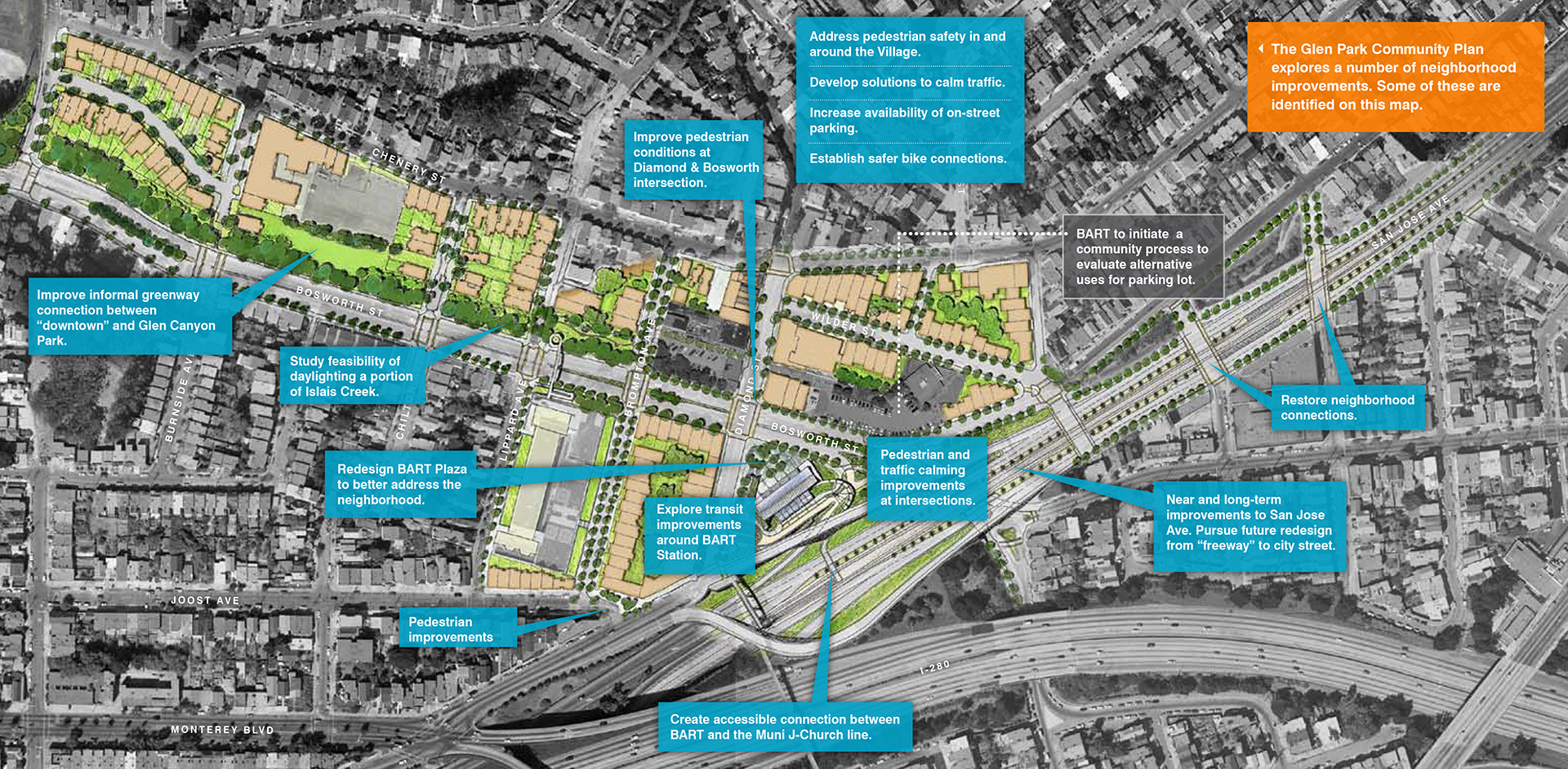
This intersection is the busiest in Glen Park - not only for pedestrians but also for vehicles. It serves as a gateway to the neighborhood and the commercial district. To reduce vehicle-pedestrian conflicts and strengthen neighborhood identity, pedestrian and streetscape improvements should be implemented. An intersection design that improves pedestrian conditions and access to the BART station should be developed.
Bosworth Street Underpass
The looming San Jose Avenue overpass above Bosworth Street creates an unwelcoming pedestrian environment and is a source of security concerns, especially at night. High-intensity lighting, pedestrian-scale street lamps, wall-mounted art or other treatments should be considered to improve the aesthetics and safety of this location. Removal of the overpass to restore a street level intersection should be explored as part of a future San Jose Avenue redesign (see Policy 9.2).
Pedestrian crossings along Bosworth Street
Limited marked crossing opportunities cause many pedestrians to jaywalk across traffic. The City should determine where additional crosswalks may be installed along Bosworth Street.
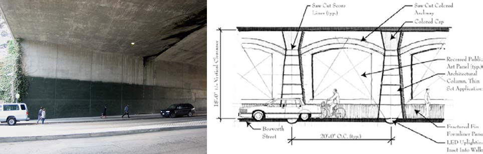
Mega infrastructure such as the Bosworth Street underpass can be humanized through streetscape design improvements that restore a pedestrian scale and character to the street.
POLICY 4.2
Prohibit new curbcuts or driveways on key commercial and pedestrian streets such as Diamond and Chenery Streets.
To reduce pedestrian/vehicle conflicts and support a continuous retail frontage, new driveways should be restricted on portions of downtown Glen Park’s most walkable shopping streets.
Bicycles
Glen Park serves as a critical link in the larger citywide bicycle network. The area’s steep topography and tangle created by the I-280 freeway and San Jose Avenue present a variety of challenging conditions for bicyclists. The San Francisco Bicycle Plan proposes a number of projects aimed at improving bicycle connections in Glen Park.
OBJECTIVE 5
IMPROVE ACCESS FOR BICYCLISTS TO GLEN PARK AND THE BART STATION
POLICY 5.1
Implement bicycle network improvements identified in the San Francisco Bicycle Plan.
The Bicycle Plan proposed a set of projects in Glen Park to fill remaining gaps in the City’s bicycle network. These should be implemented to improve safety and bicycle access through Glen Park and to BART. Projects include:
-
Bike lanes on Lyell Street
-
Bike lanes on Bosworth between Diamond and Rotteck Streets
-
Bike Lanes on Monterey Boulevard on and off ramps from San Jose Avenue
-
Arlington Street shared lane bike markings (“sharrows”)
-
Bosworth Street shared lane markings (“sharrows”)
POLICY 5.2
Consider increased opportunities for bicycle parking in Glen Park
Glen Park residents and merchants should work with the SFMTA to consider expanding both on-street and off-street bicycle parking near major destinations such as the commercial area, BART station, Muni, and Glen Canyon Park.
Public Transit
One of Glen Park’s greatest assets is its strong public transit infrastructure. Glen Park is served by four Muni bus lines (23-Monterey, 36-Teresita, 44-O’Shaugnessy, and 52- Excelsior), the J-Church Muni metro line and BART’s regional rail lines. In addition to public transit, a number of private employers operate shuttle buses to the BART station. Approximately 9,000 transit riders get on or off Muni, BART or shuttle buses in downtown Glen Park each day. Glen Park’s role as an important transit center for the neighborhood, city, and the region should be maintained. Improvements to transit include making service more accessible, reducing curbside conflicts and strengthening connections between Muni and BART.
OBJECTIVE 6
SUSTAIN GLEN PARK’S ROLE AS AN IMPORTANT INTERMODAL TRANSIT CENTER FOR THE CITY AND REGION
POLICY 6.1
Implement recommendations of the San Francisco Municipal Transportation Agency’s Transit Effectiveness Project (TEP) for the Glen Park neighborhood.
The SFMTA’s Transit Effectiveness Project (TEP) recommends the following Muni changes in Glen Park. These projects should be implemented per the TEP’s timeline:
-
Extension of the 35-Eureka bus line to the BART Station via Diamond Heights Boulevard and Diamond Street.
-
Redesign of 36-Teresita route to reach Glen Park BART Station (implemented).
POLICY 6.2
Manage curb space around the Glen Park BART station to improve the function of transit.
The limited curb space surrounding the BART station creates competition for passenger loading and unloading between Muni buses, employer shuttles and automobile pick-up and drop-off. Reconfiguration of bus stops and loading areas should be considered to reduce conflicts.
POLICY 6.3
SFMTA and BART should determine which future capital investments may be appropriate for transit.
The SFMTA has studied the technical feasibility of various projects to improve transit operation in Glen Park. While technically feasible, some projects may be prohibitive in terms of cost or operational efficiency. The SFMTA and BART should make appropriate recommendations based on agency goals, community input and environmental findings.
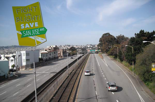
Rethinking San Jose Avenue
San Jose Avenue began as the path of a narrow railroad line that was widened through the years to become the expansive roadway we see today. As a five-lane arterial street, San Jose Avenue looks and acts more like a freeway than a city street with its high speeds, on/off-ramps, and limited pedestrian and bicycle facilities.
In addition, the neighboring communities of Glen Park, St. Mary’s Park and Bernal Heights are bisected by the roadway prohibiting direct pedestrian, transit and vehicle connections. This results in circuitous traffic movements, congestion on local streets and livability concerns for nearby residents.
The Glen Park Community Plan recommends both near and long-term design improvements to transform San Jose Avenue into an attractive boulevard that is better integrated into surrounding neighborhoods. (See Policy 9.2)
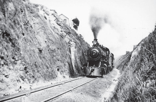
1864
San Jose Avenue began as a sunken railroad route called the “Bernal Cut.”
1930
The Bernal Cut was eventually widened to accommodate a four-lane automobile route, streetcar tracks and a railroad line. Bridges were built at Miguel and Highland Streets to cross the sunken roadway. The street increased automobile access to Glen Park and areas further south.
1953
Highway planners of the 1950s envisioned San Jose Avenue as part of a larger freeway extending through the Mission District. While the citizen-led Freeway Revolt curtailed these plans, the street was rebuilt with a typical freeway design - multiple traffic lanes, limited crossing opportunities and long on/off ramps.
2011
Community members have begun to advocate for improvements to San Jose Avenue. Carefully designed street changes could increase livability for neighbors while improving circulation in surrounding neighborhoods, transit access and pedestrian/bicycle safety.
OBJECTIVE 7
IMPROVE ACCESS TO PUBLIC TRANSIT IN GLEN PARK
POLICY 7.1
Make transit more accessible.
The area’s grade changes make ADA (Americans with Disabilities Act) compliant access to transit services particularly challenging. Improvements that make BART and Muni service more accessible should be pursued.
J-Church Platform
The only access between the J-Church light rail platform located on San Jose Avenue is over a pedestrian bridge with stairs. Riders who use wheelchairs are unable to access the stop. A reconfigured pedestrian bridge with ADA compliant ramp or at-grade pedestrian crossing of San Jose Avenue would help improve access. Long-term plans should consider moving the J-Church platform to better serve the “village” and allow access by neighborhoods to the south. A future redesign of San Jose Avenue should consider the possibility of removing the Bosworth Street overpass to create a street level intersection with J-Church stop (see Policy 9.2).
BART & Muni
Only two of the three BART station’s entrances are accessible. The station should be made fully accessible by reconfiguring or redesigning the BART plaza.
POLICY 7.2
Encourage and work with BART on a redesign of the Glen Park BART station plazas to improve pedestrian and transit access and better connect the commercial district.
The underused plazas surrounding the BART station offer a tremendous opportunity to serve thousands of transit riders, more seamlessly link the commercial district and provide high-quality public space. The plaza should be upgraded and made fully accessible by removing walls and fences, expanding at-grade access and linking Muni passenger areas.
Vehicle Circulation
Vehicle circulation challenges in Glen Park have impacted both neighborhood livability and walkability. During rush hours, congested intersections create vehicle-pedestrian conflicts and lure drivers to detour through narrow residential streets. Freeway structures limit connections among the area’s streets and force drivers to make overly circuitous movements. Strategic interventions at key locations should be made to manage traffic flow and create better neighborhood serving streets. Technical analysis of the area’s circulation and roadway network should be carried out to determine if alternative scenarios could benefit movement in the area.
OBJECTIVE 8
SEEK IMPROVEMENTS THAT RELIEVE TRAFFIC CONGESTION WHILE MINIMIZING IMPACTS ON OTHER TRANSPORTATION MODESenvironment
POLICY 8.1
Improve the function of major intersections in Glen Park without further degrading the pedestrian environment or neighborhood character.
Strategic solutions to address areas of known congestion or conflict should be considered. While conditions for automobiles should be improved if possible, further degradation of the pedestrian environment must be avoided. The following intersections require improvement.
Diamond and Bosworth Streets
Traffic congestion on Bosworth and Diamond Streets builds as vehicles funnel through Glen Park to reach the BART station or access the freeway. Turning vehicles clog the intersection blocking straight-through traffic. High pedestrian volumes further constrict the ability of cars to turn. Improvements that support the needs of pedestrians while allowing traffic flow should be pursued.
Bosworth/Arlington/I-280 on-ramp
This intersection’s odd geometry creates confusing turn movements and offers no pedestrian crossing across Bosworth. Intersection treatments could make traffic movements more predictable and allow the installation of pedestrian crosswalks. The SFMTA and Caltrans should determine what type of treatment may be appropriate.
OBJECTIVE 9
RESTORE THE LOCAL IMPORTANCE OF STREETS IN THE AREA
Major vehicle infrastructure projects of preceding decades focused on improving conditions for cross-town and regional traffic in Glen Park. The Freeway construction boom of the 1950s & 60s created the I-280 freeway and the freeway-like stretch of San Jose Avenue. These projects changed the character of the area by increasing vehicle speeds and cut-through traffic. Opportunities exist to restore the neighborhood function back to Glen Park’s streets.
POLICY 9.1
Calm traffic throughout Glen Park, especially through-traffic and freeway-oriented traffic.
High vehicle speeds and cut-through traffic diminish the comfort of pedestrians and adversely affect residents. Traffic calming treatments at key locations: the intersections of Joost/Monterey Boulevard, Arlington/Wilder and Bosworth/Lyell should be implemented to help reduce speeds and improve pedestrian and bicycle movement. Curb bulb outs, new pedestrian crossings, widened medians or other treatments may be appropriate.
POLICY 9.2
Conduct further analysis to determine the feasibility of near and long-term improvements for San José Avenue including redesign of the street as a boulevard to improve safety, livability and better connect surrounding neighborhoods.
San Jose Avenue is a four-lane road but looks and acts more like a freeway than a city arterial street. The City in conjunction with Caltrans should conduct further analysis to determine the feasibility of converting the freeway-like portion of San José Avenue into an attractive city boulevard, similar to Dolores Street or Octavia Boulevard. Any proposal of this scale represents a long-term future vision and would require additional traffic, engineering and environmental studies as well as extensive community outreach and funding to implement.
Conversion of San Jose Avenue into a street of more typical local character would involve roadway redesign, streetscape beautification, reduction in vehicle speeds and creation of new intersections to connect neighborhoods that San Jose Avenue currently acts as a barrier between. A possible project component includes the removal of the San Jose Avenue overpass at Bosworth Street to reduce the grade separation between the two streets and restore a street level intersection. This would allow the possibility of creating a new Muni J-Church stop that is better integrated into the neighborhood.
Near-term traffic calming improvements supported by SFMTA and Caltrans such as lowered speeds, improved pedestrian/bicycle conditions, flashing radar speed signs, or lane reduction should be considered until a larger structural change is possible.
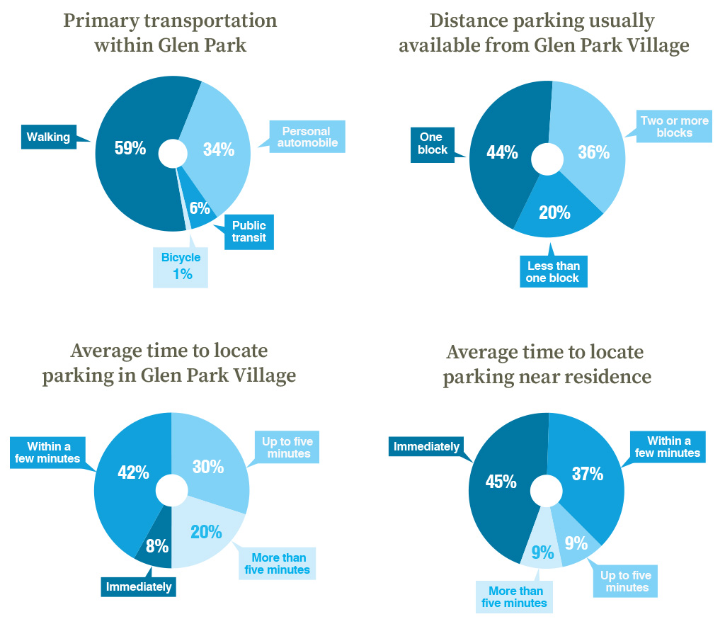
Parking
All of San Francisco’s neighborhoods face on-street parking challenges. Glen Park is no different. The neighborhood is fortunate in that many homes are located within walking distance of downtown Glen Park and the BART station. Parking availability, however, is a subject of concern for Glen Park’s residents. Neighbors have noted problems with BART commuter parking, abuse of disabled parking placards by some drivers and the crowding of on-street parking spaces by residents who use garages for storage or workspace rather than parking.
Regulating and managing parking is a complicated matter. The more parking that is provided, the more cars and congestion Glen Park will attract. If not enough parking is provided or spaces remain occupied, residents, visitors and shoppers will have difficulty accessing the area. A reasonable amount of parking should be provided while at the same time walking and transit made more desirable and convenient.
Glen Park(ing)
Parking in Glen Park is a subject of heated discussion. Lively conversations at public workshops took place regarding the availability of on-street parking spaces. In response to strong interest in the subject, the San Francisco Municipal Transportation Agency (SFMTA) conducted further analysis.
A survey of neighborhood residents was conducted to collect an unbiased assessment of on-street parking issues. A random sample of 815 addresses was selected from within the Plan area. Surveys were mailed with questions regarding where people park, when they park and how long it takes to find a space. In addition, parking availability in the neighborhood was monitored by counting both vacant and occupied on-street parking spaces at different times of day.
The results of the analysis (Figures 3 & 4) indicate that while parking may not be as convenient as residents would like, spaces can usually be found near destinations within reasonable amounts of time. The Plan recommends maintaining and improving Glen Park’s on-street parking availability through better management, enforcement and ongoing adjustment of parking controls.
Figure 3: On-Street Parking Availability - Weekdays
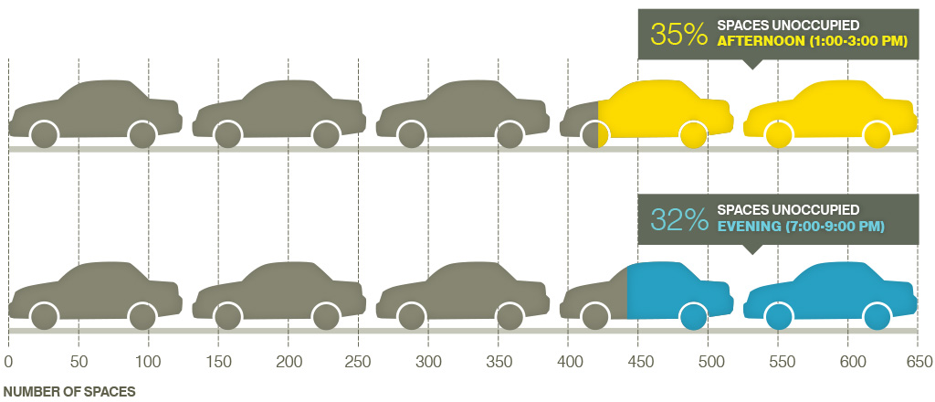
Figure 4: On-Street Parking Survey Results
OBJECTIVE 10
OPTIMIZE USE OF EXISTING ON-STREET PARKING SPACES IN GLEN PARK
Glen Park residents have noted that parking can be difficult during certain times of day or week. Rather than creating new parking spaces and introducing related congestion and traffic, demand for existing parking spaces should be optimized to improve parking availability at all times of day.
POLICY 10.1
Pursue strategies to increase the availability of on-street parking.
Various strategies should be employed to achieve desirable levels of parking availability in both residential and commercial areas. These include:
-
Residential Permit Parking (RPP) Program
The SFMTA’s RPP Program offers the opportunity for residents to reduce parking demand on residential streets. Formed by resident request, permit parking areas give permit holders priority for spaces over others. These areas should be expanded and/or modified as needed. -
Parking Enforcement
Enforcement of parking controls in Glen Park is necessary to ensure the availability of parking spaces. SFMTA should provide levels of enforcement to ensure appropriate use of spaces and promote parking availability. -
State Legislative Reform
The California Department of Motor Vehicles is responsible for management and enforcement of Disabled Parking Placards. Roughly 60,000 disabled plates and placards have been issued in San Francisco – about 1 for every 15 residents. These allow holders to park for an unlimited amount of time at on-street spaces for free. Placards are essential to the mobility of disabled persons who require additional time to complete tasks or require parking close to destinations. However, those fraudulently displaying placards can occupy spaces all day preventing use by people with actual disabilities. The City and SFMTA are pursuing state legislation that would allow closer scrutiny of permits for disabled placards. -
Adjustable Rate/Time Parking Meters
The SFMTA has been pioneering the use of innovative on-street parking strategies that utilize variable pricing to help make parking spaces available when and where they are needed. At some point Glen Park may want to experiment with this strategy to determine its usefulness in increasing parking availability in the commercial area.
POLICY 10.2
Improve neighborhood walkability, comfort and safety to alleviate the need for some local vehicle trips.
Some residents choose to drive out of concerns for personal safety or unfriendly pedestrian conditions. Efforts should be made to improve the pedestrian environment and make walking a more attractive transportation choice. Options include: additional street furniture, provision of bulb-outs, sidewalk widening, and street tree planting where appropriate, based on the Better Streets Plan and Department of Public Works’ guidelines.
POLICY 10.3
Support carsharing in Glen Park as way to reduce private vehicle demand and parking.
Carsharing offers an affordable alternative to car ownership by allowing individuals the use of a car without the cost of ownership (gas, insurance, maintenance). Many drivers use one vehicle for short-term trips. This allows for the efficient use of a single vehicle and can lead to reduction in parking demand. While carsharing is managed primarily by companies and private land holders, the Plan supports their presence in the area.
Open Space
Glen Park’s open spaces provide recreational opportunities, public gathering places and the opportunity to connect with nature. Only a short walk from the BART station, Glen Canyon Park offers a stunning natural area with beautiful rock outcrops, hiking trails, ball fields and tennis courts. One of San Francisco’s last free flowing creeks – Islais Creek – winds through the canyon.
While downtown Glen Park bustles with people throughout the day, the village lacks strong public open spaces. Opportunities exist to transform underutilized areas into lively green spaces, parks and plazas.
OBJECTIVE 11
MAINTAIN AND IMPROVE GLEN PARK’S MIX OF PUBLIC OPEN SPACES
POLICY 11.1
Sustain and improve the informal greenway and pedestrian path connecting downtown Glen Park to Glen Canyon Park.
The vacant City-owned parcels along Bosworth Street function as an informal trail and greenway through Glen Park. This path provides a valuable green resource for the neighborhood. The opportunity exists to create an attractive linear greenway and safe walking route between the village and Glen Canyon Park. Located along the historic creek channel, the greenway could also provide opportunities to honor the area’s watershed and historic ecology with signage, an art installation or possible creek “daylighting” project.
POLICY 11.2
Recognize Kern Street and the BART plazas as important public space opportunities.
Kern Street
Since it does not function as a through street and has few cars, the one block of Kern Street provides a unique opportunity to provide new public space in downtown. Special pavement, street trees and shared street treatments could provide room for outdoor seating, dining and gathering. If the parking lot along Kern is ever developed, opportunities to orient commercial uses towards the street should be considered. Kern Street could also function as the entrance to a greenway linking the commercial district to Glen Canyon.
BART Plazas
The Glen Park BART station is located on the busiest corner in the Plan area. However, despite its prominent location, the plaza is essentially walled off from the adjacent community and much of Bosworth Street. The small plaza located in the southern end of the station is also underutilized. Redesign of these areas could make them more inviting, better for transit and provide much needed public space.
POLICY 11.3
Look for opportunities to reclaim some street space in the commercial core for use as open space.
Narrow sidewalks in the commercial area provide little room for gathering or socializing. The conversion of a parking space or two into a “parklet” – a small open space with seating, planters and bicycle parking – could help support the social and street life of the village. Such a project would need to be initiated by merchants or community members.
POLICY 11.4
The San Francisco Public Utilities Commission (SFPUC) and Planning Department should conduct a study to assess the feasibility, benefits and impacts of daylighting a portion of Islais Creek through Glen Park.
Islais Creek once flowed freely from Glen Park to the San Francisco Bay. Today the creek is only visible for a small stretch in Glen Canyon before it disappears underground into a culvert beneath the recreation center. Creek “daylighting” is the redirection of a stream into above-ground channels. The City should conduct a study to assess the feasibility of such a project and identify potential impacts and benefits. Some residents have expressed concerns related to flooding, maintenance, erosion, pest control, public safety and risks to adjacent property owners. These concerns should be assessed as part of any future study.
Open Space Concepts
BART Plaza Redesign
The Plan proposes a linear recreational greenway connecting downtown Glen Park with Glen Canyon Park. The proposed greenway path is located along vacant City-owned parcels. This path features large mature trees including Monterey pine, eucalyptus, and others that screen the area from Bosworth Street and provide a quiet green refuge.
BART Plaza Redesign
The Glen Park BART station’s circular plaza shown above is walled off from the activity and life on surrounding streets and transit stops. This creates a feeling of disconnection and a pattern of underuse. A redesign that better integrates the station and plaza into the surrounding area could provide high quality public space in the heart of Glen Park.
Village Parklet
The narrow sidewalk widths and limited outdoor seating opportunities in Glen Park’s commercial area make a parklet an inexpensive and attractive option in the village. Parklets have been installed in neighborhoods throughout San Francisco through the City’s Pavement to Parks Program. Such a project would need to be initiated by residents or merchants.
Islais Creek: Nature in the Village
Once San Francisco’s largest body of water, Islais Creek provided an important source of habitat, drinking water and irrigation. The massive creek flowed from Glen Canyon to San Francisco Bay. Today it is buried almost completely beneath urban development.
History: Islais Creek and its wetlands supported a rich habitat and feeding ground for birds, elk, mountain lions and grizzly bears. The Ohlone people harvested shellfish on its shores. As the city expanded during the Gold Rush, homes and industry sprang up on the creek’s banks. Islais Creek became used as a primitive sewer system for slaughterhouses, farms and residential development. The creek’s condition severely deteriorated. By the early 1900’s, the creek was largely filled and its flow diverted into underground pipes.
Islais Creek & Glen Park: Islais Creek’s only remaining free flowing remnant is the creek’s upstream branch within Glen Canyon Park. Here the creek provides a beautiful natural feature and nourishes the canyon’s habitat and wildlife. It disappears below the recreation center into a series of sewer pipes that flow beneath the neighborhood.
The Bay Area’s buried creeks are now being recognized as lost ecological and community resources. Cities such as Berkeley, Oakland, Santa Rosa and Castro Valley have all successfully restored creeks to the surface through a process called “daylighting.” Creek “daylighting” is the redirection of a stream into above-ground channels. Islais Creek in Glen Park is a potential candidate for a similar treatment.
A daylighted Islais Creek could introduce a new recreational amenity, add habitat value and help sustainably manage stormwater. In addition, a creek feature could complement the proposed linear greenway connecting the canyon with downtown Glen Park. The Community Plan calls for further study to determine the feasibility of such a strategy and to address community concerns related to flooding, maintenance, erosion, pest control, public safety and impacts on adjacent property owners (see Policy 11.4).
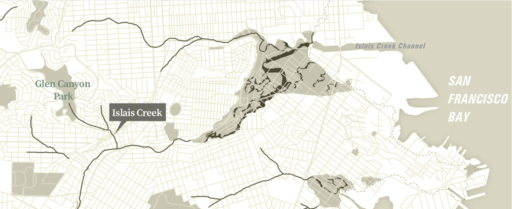
Islais Creek’s historic path (1895) shown overlaid on current city map.
Implementation Program
This Implementation Program outlines follow-up actions recommended to put the Plan’s vision on the ground. The table below will provide guidance to City agencies on projects, programs and further studies to implement the Glen Park Community Plan.
| Project | Action | Key Agency | Timeframe | Potential Funding Source |
|---|---|---|---|---|
| LAND USE & URBAN DESIGN | ||||
| Revised Neighborhood Commercial Zoning |
Update Planning Code to reflect zoning change of existing neighborhood commercial district (NC-2) to Glen Park Neighborhood Commercial Transit (NCT) district |
Planning | Upon Plan adoption | Planning Department |
| Streetscape Improvements |
Develop streetscape strategy for core village area to include some or all of the following benches, new bus shelters, newsrack consolidation, bulbouts, possible sidewalk widening, utility undergrounding and street tree planting. |
Planning, BART, SFMTA, DPW | Ongoing | Grants |
| BART parking lot site |
Pending outcome of future BART community process, review and consider proposals for alternative uses on parking lot |
Planning | Pending BART proposals | Planning Department, BART |
| Historic Preservation |
Present historic resources survey for adoption to Historic Preservation Commission (HPC) |
Planning | Near-term (1-5 years) |
Planning Department |
|
Nominate eligible properties to the California Register of Historical Resources |
Planning | Near-term (1-5 years) |
Planning Department | |
| TRANSPORTATION | ||||
| Pedestrian Improvements |
Prioritize and proceed with implementation of pedestrian street improvements:
|
SFMTA, Planning, DPW, BART | Near-term (1-5 years) |
State, regional, federal grants, existing department budgets, Prop K sales tax |
| Bicycle Network projects |
Implement Glen Park bicycle projects as identified in San Francisco Bicycle Plan including:
|
SFMTA | Completed | Funded |
| Bicycle Parking |
Install additional bicycle parking where needed. Possible locations include commercial area, BART, and near Glen Canyon Park |
SFMTA, BART | Ongoing | State, regional, federal grants, local sources |
| Transit Service Adjustments |
Implement poposed Transit Effectiveness Project (TEP) routing changes:
|
SFMTA | In Process | SFMTA |
| Transit capital investments |
Determine which long-term transit capital projects should be pursued in Glen Park. Projects may include:
|
SFMTA, BART | Mid and long-term (5-10+ years) |
State, regional, federal grants, SFMTA, BART, Prop K sales tax |
| BART Plaza Redesign |
Design and construct reconfigured BART plaza |
BART, SFMTA, Planning | Mid-term (5-10 years) |
State, regional, federal grants, BART |
| Traffic Calming and Vehicle Circulation projects |
Prioritize and implement traffic calming and vehicle circulation projects. Project elements may include pedestrian bulb-outs, new crosswalks, pedestrian refuge islands, traffic control changes, striping changes or other treatments:
|
SFMTA, Planning, Caltrans | Mid-term (5-10 years) |
State, regional, federal grants, SFMTA |
| San Jose Avenue near-term traffic calming improvements |
Identify and implement appropriate near-term traffic calming improvements such as signage, striping changes, decreased speeds, bicycle improvements, radar speed signs or other measures |
SFMTA, Caltrans | Near-term (1-5 years) |
State, regional, federal grants, existing department budgets, Prop K sales tax, Caltrans |
| San Jose Avenue Redesign |
Conduct a design and engineering study to determine the feasibility of redesigning San Jose Avenue as a local street and attractive boulevard (with and without the removal of the Bosworth Street overpass) that is better integrated into surrounding neighborhoods |
SFMTA, SFCTA, Caltrans, Planning | Near-term (1-5 years) |
State, regional, federal grants, existing department budgets, Prop K sales tax |
| OPEN SPACE | ||||
| Greenway Design |
Develop landscape design for a linear recreational greenway linking the Glen Park neighborhood commercial area to Glen Canyon Park along City-owned Bosworth Street parcels and nearby streets |
Rec Park, SFPUC, DPW, Planning | Near-term (1-5 years) |
Existing department budgets, grants |
| Greenway Construction and Maintenance |
Build and maintain linear recreational greenway path linking the Glen Park neighborhood commercial area to Glen Canyon Park along City-owned Bosworth Street parcels and nearby streets |
Rec Park, SFPUC, DPW, Planning | Mid-term (5-10 years) |
State, regional, federal grants, Prop K sales tax |
| Islais Creek Study |
Conduct study to determine engineering feasibility, benefits and potential impacts of daylighting a portion of Islais Creek through Glen Park with attention given to adjacent property owners’ concerns |
SFPUC, Planning | Near-term (1-5 years) |
SFPUC, grants |
| BART Plaza Redesign |
Design and construct reconfigured BART plaza |
BART, SFMTA, Planning | Mid-term (5-10 years) |
State, regional, federal grants, BART, SFMTA |
| Glen Park Village “parklet” |
If initiated by community, convert parking stall(s) into small open space with seating, tables, planters and/or bicycle parking |
SFMTA, Planning, DPW | Near-term (1-5 years) |
Pavement to Parks program, donations |
Glen Park Community Plan adopted by the Board of Supervisors Ordinance No. 0037-12 on 02/14/2012.
Amendments by Board of Supervisors Ordinance 0243-25 adopted on 12/09/2025.