Western Shoreline Area Plan
INTRODUCTION
The conservation of the California coast has always been of interest and concern to San Francisco. From the early years of the city’s history, the coastal beach and cliff areas have been an important recreational and natural resource to the people of San Francisco and the Bay Area. There has always been an intense interest among the city’s citizens in maintaining the area for the use and enjoyment of the public. This position was underscored by the enthusiastic participation of the City in establishing the Golden Gate National Recreation Area and the overwhelming voter support for Proposition 20 in 1972 which led to the passage of the Coastal Act of 1976. Pursuant to that act San Francisco prepared a Local Coastal Program adopted by the City Planning Commission, and the Board of Supervisors, and certified by the California Coastal Commission on April 26, 1984.
The City Planning Commission is responsible for adopting and maintaining a comprehensive long-term general plan for future development of the City and County of San Francisco known as the Master Plan. The Plan is divided into a number of functional elements, including Urban Design, Residence, Recreation and Open Space, Commerce and Industry, Environmental Protection, Transportation, and a number of subarea plans, including the Civic Center Plan, Northeastern Waterfront Plan and the Central Waterfront Plan.
The policies of the Local Coastal Program, together with the addition of summary objectives to the various section readings to make it compatible with other area plans, are being incorporated in the City’s Master Plan, as an area plan under the title Western Shoreline Plan.
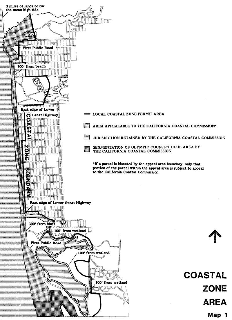
The San Francisco Coastal Zone extends approximately 6 miles along the western shoreline from the Fort Funston cliff area in the south to the Point Lobos recreational area in the north. The south end of the Coastal Zone includes the Lake Merced area, the Zoo, the Olympic Country Club, and the seashore and bluff area of Fort Funston. The Coastal Zone spans the Ocean Beach shoreline and includes Golden Gate Park west of Fortieth Avenue, the Great Highway corridor and the adjacent residential blocks in the Sunset and Richmond districts. The north end of the seashore includes the Cliff House and Sutro Baths area, Sutro Heights Park, and Point Lobos recreational area.
Most of the San Francisco western shoreline is publicly owned. Golden Gate Park, the Zoo, and Lake Merced contain 60% of the 1,771 acres which comprise the Coastal Zone area. Another 25% of the Coastal Zone is within the Golden Gate National Recreation Area (GGNRA). Only 14% of the land is privately owned, and 9% of this land is within the Olympic Country Club area. The remainder 5% is private residential and commercial property which fronts or lies in close proximity to the seashore.
The Coastal Zone is the area shown on Map 1.
The area covered by the Western Shoreline Plan is divided into ten subareas as listed below and shown on Map 2.
- The Great Highway
- Golden Gate Park
- The Zoo
- Lake Merced
- Ocean Beach
- Sutro Heights Park
- Cliff House Sutro Baths
- Fort Funston
- Olympic Country Club
- Richmond and Sunset Residential Neighborhoods
The Plan consists of transportation policies for the entire Coastal Zone and of specific policies relating to the ten subareas.
OBJECTIVES AND POLICIES
Transportation
OBJECTIVE 1
IMPROVE PUBLIC TRANSIT ACCESS TO THE COAST.
POLICY 1.1
Improve crosstown public transit connections to the coastal area, specifically Ocean Beach, the Zoo and the Cliff House.
POLICY 1.2
Provide transit connections amongst the important coastal recreational destinations
POLICY 1.3
Connect local transit routes with regional transit, including BART, Golden Gate Transit, and the Golden Gate National Recreation Transit.
POLICY 1.4
Provide incentives for transit usage.
POLICY 1.5
Consolidate the Municipal Railway turnaround at the former Playland-at-the-Beach site.
POLICY 1.6
Provide transit shelters at the beach for transit patrons.
The Great Highway
OBJECTIVE 2
REDESIGN THE GREAT HIGHWAY TO ENHANCE ITS SCENIC QUALITIES AND RECREATIONAL USE.
POLICY 2.1
Develop the Great Highway right-of-way as a four lane straight highway with recreational trails for bicycle, pedestrian, landscaping, and parking. Emphasize slow pleasure traffic and safe pedestrian access to beach.
POLICY 2.2
Maintain the landscaped recreational corridor adjacent to the development at the former Playland-at-the-Beach site to provide a link between Golden Gate park and Sutro Heights park.
POLICY 2.3
Provide for a continuation of the bicycle trail by an exclusive bicycle lane on public streets between the Great Highway and Point Lobos.
POLICY 2.4
Improve public access to Ocean Beach from Golden Gate Park by providing a landscaped bridge over vehicular underpass, if funds are not available improve public access by providing grade crossings with signals, walkways, lighting and landscaping.
POLICY 2.5
Locate parking for users of Ocean Beach and other coastal recreational areas so that the Great Highway need not be crossed. Provide limited parking east of the highway for park use. Design parking to afford maximum protection to the dune ecosystem.
POLICY 2.6
Provide permanent parking for normal use required by beach users in the Great Highway corridor (taking into account the increased accessibility by transit); provide multiple use areas which could be used for parking at peak times, but could be used for recreational uses when not needed for parking.
POLICY 2.7
improve pedestrian safety by providing clearly marked crossings and installing signalization.
POLICY 2.8
Enhance personal safety by lighting parking areas and pedestrian crossings.
POLICY 2.9
Improve public access to Ocean Beach south of Lincoln Way by providing grade crossing with signals and walkways at every other block.
Golden Gate Park
OBJECTIVE 3
ENHANCE THE RECREATIONAL CONNECTION BETWEEN GOLDEN GATE PARK AND THE BEACH FRONTAGE.
POLICY 3.1
Strengthen the visual and physical connection between the park and beach. Emphasize the naturalistic landscape qualities of the western end of the park for visitor use. When possible eliminate the Richmond-Sunset sewer treatment facilities.
POLICY 3.2
Continue to implement a long-term reforestation program at the western portion of the park.
POLICY 3.3
Develop and periodically revise a Master Plan for Golden Gate Park to include specific policies for the maintenance and improvement of recreational access in the western portion of the park.
POLICY 3.4
Rehabilitate the Beach Chalet for increased visitor use.
The Zoo
OBJECTIVE 4
IMPROVE THE QUALITY OF THE ZOO AND ITS RELATIONSHIP TO THE COASTAL ZONE RECREATIONAL SYSTEM.
POLICY 4.1
Maintain the landscaped park-like atmosphere of the Zoo.
POLICY 4.2
Enhance visitor interest in the Zoo by pursuing a specific Zoo Master Plan for modernization and improvement of Zoo facilities and enhancement of the animal collection.
POLICY 4.3
Allow location of a sewage treatment plant and a pump station to serve the western area of San Francisco on Zoo property. Locate and design the facilities to maximize their joint use by the Zoo.
POLICY 4.4
Expand the existing Zoo area west toward the Great Highway and south toward Skyline Boulevard.
POLICY 4.5
Provide a wind berm along the Great Highway for protection and public viewing of Ocean Beach and the Pacific Ocean.
POLICY 4.6
Enhance the entrance to the Zoo by providing visitor amenities at the northwest corner.
POLICY 4.7
Provide parking near the entrance to the Zoo for those visitors who cannot reasonably use public transportation.
POLICY 4.8
Provide for the reasonable expansion of the Recreation Center for the Handicapped for recreation purposes. Accommodate that expansion in a way that will not inhibit the development of either the Zoo or the treatment plant.
Lake Merced
OBJECTIVE 5
PRESERVE THE RECREATIONAL AND NATURAL HABITAT OF LAKE MERCED.
POLICY 5.1
Preserve in a safe, attractive and usable condition the recreational facilities, passive activities, playgrounds and vistas of Lake Merced area for the enjoyment of citizens and visitors to the city.
POLICY 5.2
Maintain a recreational pathway around the lake designed for multiple use.
POLICY 5.3
Allow only those activities in Lake Merced area which will not threaten the quality of the water as a standby reservoir for emergency use.
POLICY 5.4
As it becomes obsolete, replace the police pistol range on the southerly side of South Lake with recreational facilities.
Ocean Beach
OBJECTIVE 6
MAINTAIN AND ENHANCE THE RECREATIONAL USE OF SAN FRANCISCO’S OCEAN BEACH SHORELINE.
POLICY 6.1
Continue Ocean Beach as a natural beach area for public recreation.
POLICY 6.2
Improve and stabilize the sand dunes where necessary with natural materials to control erosion.
POLICY 6.3
Keep the natural appearance of the beach and maximize its usefulness by maintaining the beach in a state free of litter and debris.
POLICY 6.4
Maintain and improve the physical condition and appearance of the Esplanade between Lincoln Way and the Cliff House.
POLICY 6.5
Enhance the enjoyment of visitors to Ocean Beach by providing convenient visitor-oriented services, including take-out food facilities.
POLICY 6.6
Extend the seawall promenade south to Sloat Boulevard as funds become available.
Sutro Heights Park
OBJECTIVE 7
PRESERVE AND RESTORE SUTRO HEIGHTS PARK.
POLICY 7.1
Continue the use of Sutro Heights Park as a park, preserve its natural features, and retain its quiet neighborhood orientation.
POLICY 7.2
Restore elements of the historic garden and landscaping and include minor interpretive displays and seating areas.
POLICY 7.3
Improve access between Golden Gate Park and Sutro Heights Park by providing a new trail system up the south slope of Sutro Heights Park within the La Playa Street right-of-way for equestrians, pedestrians and joggers.
POLICY 7.4
Protect the natural bluffs below Sutro Heights Park. Keep the hillside undeveloped in order to protect the hilltop landform, and maintain views to and from the park. Acquire the former Playland-at-the-Beach site north of Balboa if funds become available.
Cliff House - Sutro Baths
OBJECTIVE 8
MAINTAIN THE VISITOR ATTRACTIVENESS OF THE CLIFF HOUSE AND SUTRO BATH COMPLEX.
POLICY 8.1
Develop the Cliff House/Sutro Bath area as a nature-oriented shoreline park. Permit limited commercial-recreation uses if public ownership is retained and if development is carefully controlled to preserve the natural characteristics of the site.
POLICY 8.2
Restore the Cliff House to its 1909 appearance or, if financially feasible, to an accurate replica of the original 1890 structure.
POLICY 8.3
Insure hiker safety by providing a clearly marked and well maintained pathway system.
POLICY 8.4
Redesign parking and vehicular circulation in the area to relieve congestion and provide for the safety of pedestrians crossing Point Lobos.
POLICY 8.5
To increase visitor enjoyment, mitigate the noise and air pollution caused by tour buses by relocating bus waiting areas.
Fort Funston
OBJECTIVE 9
CONSERVE THE NATURAL CLIFF ENVIRONMENT ALONG FORT FUNSTON.
POLICY 9.1
Maximize the natural qualities of Fort Funston. Conserve the ecology of entire Fort and develop recreational uses which will have only minimal effect on the natural environment.
POLICY 9.2
Permit hanggliding but regulate it so that it does not significantly conflict with other recreational and more passive uses and does not impact the natural quality of the area.
Olympic Country Club
OBJECTIVE 10
RETAIN THE OPEN SPACE QUALITY OF THE OLYMPIC COUNTRY CLUB AREA.
POLICY 10.1
If the private golf course use is discontinued, acquire the area for public recreation and open space, if feasible.
POLICY 10.2
Maintain the existing public easement along the beach. Encourage the granting of an additional easement by the Olympic Country Club to the National Park Service for public use and maintenance of the sensitive bluff area west of Skyline Boulevard as part of the Golden Gate National Recreation Area.
POLICY 10.3
Protect the stability of the westerly bluffs by consolidating the informal trails along the bluff area into a formal trail system which would be clearly marked. Coordinate the lateral trail system along the bluff with the San Mateo trail system south of the San Francisco boundary.
Richmond and Sunset Residential Neighborhoods
OBJECTIVE 11
ENSURE DEVELOPMENT IN THE COASTAL ZONE ADVANCES HOUSING AND COMMUNITY DEVELOPMENT GOALS APPROPRIATE FOR THE LOCATION OF EACH PARCEL.
POLICY 11.1
Consider the location of each parcel relative to both the city context, including maior commercial and transit corridors, as well as the coast, when establishing standards for the form, design, and use of new development.
POLICY 11.2
Develop the former Playland-at-the-Beach site as a moderate density residential apartment development with neighborhood commercial uses to serve the residential community and, to a limited extent, visitors to the Golden Gate National Recreation Area.
POLICY 11.3
Continue the enforcement of citywide housing policies, ordinances and standards regarding the provision of safe and convenient housing to residents of all income levels, especially low- and moderate-income people.
POLICY 11.4
Strive to increase the amount of housing units citywide, especially units for low- and moderate-income people.
POLICY 11.5
Work with federal and state funding agencies to acquire subsidy assistance for private developers for the provision of low- and moderate-income units.
POLICY 11.6
Protect the neighborhood environment of the Richmond and Sunset residential areas from the traffic and visitor impacts from the public using adjacent recreation and open space areas.
POLICY 11.7
Maintain a community business district along Sloat Boulevard within the Coastal Zone to provide goods and services to residents of the outer Sunset and visitors to the Zoo and Ocean Beach.
Coastal Hazards
OBJECTIVE 12
PRESERVE, ENHANCE, AND RESTORE THE OCEAN BEACH SHORELINE WHILE PROTECTING PUBLIC ACCESS, SCENIC QUALITY, NATURAL RESOURCES, CRITICAL PUBLIC INFRASTRUCTURE, AND EXISTING DEVELOPMENT FROM COASTAL HAZARDS.
POLICY 12.1
Adopt Managed Retreat Adaptation Measures Between Sloat Boulevard and Skyline Drive.
Erosion ofthe bluff and beach south of Sloat Boulevard has resulted in damage to and loss of beach parking and portions of the Great Highway, and threatens existing critical wastewater system infrastructure. Sea level rise will likely exacerbate these hazards in the future. The City shall pursue adaptation measures to preserve, enhance, and restore public access, scenic quality, and natural resources along Ocean Beach south of Sloat Boulevard and to protect existing wastewater and stormwater infrastructure from impacts due to shoreline erosion and sea level rise. Federal projects in the Coastal Zone are not subject to city-issued coastal development permits. Local Coastal Program policies regarding adaptation within Golden Gate National Recreation Area simply provide guidance to both the National Park Service and California Coastal Commission, which review federal projects under the Coastal Zone Management Act. All non-federal development on federal lands is subject to coastal development permit review by the California Coastal Commission.
Implementation Measures:
(a) As the shoreline retreats due to erosion and sea level rise, incrementally remove shoreline protection devices, rubble that has fallen onto the beach, roadway surfaces, and concrete barriers south of Sloat Boulevard.
(b) Relocate public beach parking and public restrooms to areas that will not be affected by shoreline erosion or sea level rise for their expected lifespan given current sea level rise projections and mapping. The relocated facilities should not require the construction of shoreline protection devices and should be relocated if they are threatened by coastal hazards in the future.
(c) Close the Great Highway between Sloat and Skyline boulevards and make circulation and safety improvements along Sloat and Skyline boulevards to better accommodate bicyclists, pedestrians, and vehicles.
(d) Import sand to restore the beach and construct dunes. Stabilize dunes with vegetation, beach grass straw punch, brushwood fencing, or other non-structural methods.
(e) Extend the coastal trail to Fort Funston and Lake Merced by constructing a multi-use public access pathway along the shoreline from Sloat Boulevard to Skyline Boulevard.
(f) Permit shoreline protection devices if necessary to protect coastal water quality and public health by preventing damage to existing wastewater and stormwater infrastructure due to shoreline erosion onlv when less environmentally damaging alternatives are determined to be infeasible.
(g) Maintain service vehicle access necessary for the continued operation and maintenance of existing wastewater and stormwater infrastructure systems.
POLICY 12.2
Develop and Implement Sea Level Rise Adaptation Plans for the Western Shoreline.
Sea level rise and erosion threaten San Francisco's coastal resources and their impacts will worsen over time. San Francisco shall use the best available science to support the development of adaptation measures to protect our coastal resources in response to sea level rise and coastal hazards.
Implementation Measures:
(a) Conduct detailed sea level rise vulnerability assessments and develop adaptation plans to minimize risks to life, property, essential public services, public access and recreation, and scenic and natural resources from shoreline erosion, coastal flooding and sea level rise for the Western Shoreline Area.
(b) The vulnerability assessments shall be based on sea level rise protections for likely and worst-case mid-century and end-of-century sea level rise in combination with a 100-year storm event, and shall include one or more scenarios that do not rely on existing shoreline protection devices.
(c) Adaptation measures shall be designed to minimize impacts on shoreline sand supply, scenic and natural resources, public recreation, and coastal access.
(d) The adaptation plans shall consider a range of alternatives, including protection, elevation, flood proofing, relocation or partial relocation, and reconfiguration.
(e) Adaptation measures that preserve, enhance, or restore the sandv beach, dunes, and natural and scenic resources such as beach nourishment, dune restoration, and managed retreat shall be preferred over new or expanded shoreline protection devices.
(f) The adaptation plans shall consider the recommendations contained in the SPUR Ocean Beach Master Plan.
(g) Create and maintain sea level rise hazard maps to designate areas within the coastal zone that would be exposed to an increased risk of.flooding due to sea level rise. The maps shall include likely and worst case mid-century and end-of-century sea level rise projections in combination with a 100-year storm event. The maps shall include a scenario that does not include existing shoreline protection devices. The maps shall be updated when new information warranting significant adjustments to sea level rise projections becomes available.
POLICY 12.3
Develop and Implement a Beach Nourishment Program to Sustain Ocean Beach.
Shoreline erosion has substantially narrowed the sandy beach south of Sloat Boulevard. Sea level rise will likely exacerbate the loss of sandy beach south of Sloat Boulevard and may extend this effect to the north towards the Cliff House. The City shall pursue the development and implementation of a long-term beach nourishment program to maintain a sandy beach along the western shoreline to preserve Ocean Beach as a public recreational resource for future generations and to protect existing public infrastructure and development from coastal hazards.
Implementation Measure:
Work with the U.S. Army Corps of Engineers to develop and implement a beach nourishment program involving the placement of sand dredged from the San Francisco bar navigation channel offshore of the Golden Gate onto Ocean Beach. Other sources of suitable sand for beach nourishment may also be identified and permitted. Sand shall not be removed from stable dunes.
POLICY 12.4
Develop the Shoreline in a Responsible Manner.
Sea level rise and erosion impacts will worsen over time and could put private and public development in the Western Shoreline Area at risk of flooding. Given these future impacts, development in the Coastal Zone should be sited to avoid coastal hazard areas when feasible. If avoidance is infeasible, development shall be designed to minimize impacts to public safety and property from current or future flooding and erosion without reliance on current or future shoreline protection features.
New development and substantial improvements to existing development located in areas exposed to an increased risk of flooding or erosion due to sea level rise shall be designed and constructed to minimize risks to life and property.
New development and substantial improvements to existing development shall ensure stability and structural integrity, and neither create nor contribute significantly to erosion, geologic instability, or destruction of the site or surrounding area.
New development and substantial improvements to existing development shall not require the construction of shoreline protective devices that would substantially alter natural landforms along bluffs and cliffs. If new development becomes imminently threatened in the future, it shall rely on alternative adaptation measures up to and including eventual removal.
Public recreational access facilities (e.g., public parks, restroom facilities, parking, bicycle facilities, trails, and paths), public infrastructure (e.g., public roads, sidewalks. and public utilities), and coastal-dependent development shall be sited and designed in such a way as to limit potential impacts to coastal resources over the structure's lifetime. As appropriate, such development may be allowed within the immediate shoreline area only if it meets all of the following criteria:
-
The development is required to serve public recreational access and/or public trust needs and cannot be feasibly sited in an alternative area that avoids current and future hazards.
-
The development will not require a new or expanded shoreline protective device and the development shall be sited and designed to be easy to relocated and/or removed, without significant damage to shoreline and/or bluff areas, when it can no longer serve its intended purpose due to coastal hazards.
-
The development shall only be allowed when it will not cause, expand, or accelerate instability of a bluff.
POLICY 12.5
Limit Shoreline Protection Devices
Shoreline protection devices such as rock revetments and seawalls can negatively impact coastal resources by disrupting sand transport and fixing the shoreline in a specific location, leading to the eventual narrowing and ultimate loss of sandy beaches. Such structures are expensive to construct and maintain, may be incompatible with recreational uses and the scenic qualities of the shoreline, and may physically displace or destroy environmentally sensitive habitat areas associated with bluffs, dunes, beaches, and intertidal areas. Because of these impacts, shoreline protection devices shall be avoided and only implemented where less environmentally damaging alternatives are not feasible.
Shoreline protection devices such as rock revetments and seawalls shall be permitted only where necessary to protect existing critical infrastructure and existing development from a substantial risk of loss or major damage due to erosion and only where less environmentally damaging alternatives such as beach nourishment, dune restoration and managed retreat are determined to be infeasible. New or expanded shoreline protection devices should not be permitted solely to protect parking, restrooms, or pedestrian or bicycle facilities.
POLICY 12.6
Minimize Impacts of Shoreline Protection Devices.
Shoreline protection devices may be necessary to protect existing critical infrastructure or development. These shoreline protection devices shall be designed to minimize their impacts on coastal resources while providing adequate protection for existing critical infrastructure and existing development.
All shoreline protection devices shall be designed and constructed to avoid, minimize, and mitigate impacts on shoreline sand supply, environmentally sensitive habitat areas, scenic quality, public recreation, and coastal access.
Shoreline protection devices shall be designed to blend visually with the natural shoreline, provide for public recreational access, and include proportional mitigation for unavoidable coastal resource and environmentally sensitive habitat impacts.
Coastal permit applications for reconstruction, expansion, or replacement of existing shoreline protection devices shall include a re-assessment of the need for the device, the need for any repair or maintenance of the device, any additional required mitigation for unavoidable impacts to coastal resources and the potential for removal or relocation based on changed conditions. Coastal permits issued for shoreline protection devices shall authorize their use only for the life of the structures they were designed to protect.
Amendments by Board of Supervisors Ordinance 0009-18 adopted on 01/23/2018.
Amendments by Board of Supervisors Ordinance 0243-25 adopted on 12/09/2025.