Treasure Island/Yerba Buena Island Area Plan
INTRODUCTION AND PURPOSE
Treasure Island and Yerba Buena Island (collectively the “Islands”) are located in the San Francisco Bay, about halfway between the San Francisco mainland and Oakland. The Islands together consist of approximately 550 acres. Direct access to Yerba Buena Island is currently provided only by the Bay Bridge, which is linked to Treasure Island by a causeway.
Treasure Island was originally constructed in 1937 as a possible site for the San Francisco Airport, but was first used to host the Golden Gate International Exposition from 1939-1040. Shortly thereafter in World War II, the United States Department of Defense converted the island into a Naval Station, former Naval Station Treasure Island (“NTSI”). NTSI was owned by the United States Navy and operated as an active military base for more than five decades until it was closed by the Base Realignment and Closure Commission in 1993 and ceased operations in 1997. Subsequent to the closure of NTSI the Navy transferred 37 acres in the center of Treasure Island to the Department of Labor for the Job Corps Facility. Additionally, 39 acres on Yerba Buena Island is owned and operated by the U.S. Coast Guard and 18 acres by the Federal Highway Administration.
In 1997 the State legislature passed AB 699, the Treasure Island Conversion Act, which designated the Treasure Island Development Authority (“TIDA”) as a redevelopment agency under California Community Redevelopment Law with authority over NTSI and vested in TIDA the authority to administer the Public Trust for property on NTSI subject to the Public Trust. TIDA is a City agency responsible for administration of the development of the Islands, which will be implemented through a Disposition and Development Agreement with a master developer, subject to the more specific land use controls set forth in the Treasure Island / Yerba Buena Island Special Use District and the accompanying Design for Development.
Planning for the reuse of the Islands has been a long and complex process. In 1994, following the closure of NTSI a Citizens Reuse Committee (“CRC”) representing a broad base of community interests was formed to review reuse planning efforts for NTSI conducted by the City and make recommendations to the Planning Commission and Board of Supervisors concerning the reuse of NTSI. After two years of community planning, the CRC proposed and the City approved a reuse plan for NTSI. After the reuse plan was adopted, the CRC continued as the Treasure Island/Yerba Buena Island Citizens Advisory Board (“CAB”).
The CAB has been instrumental in guiding development at the Islands. The general planning principles for the Islands were developed through numerous public workshops and meetings held over a more than 15-year period. These principles have been incorporated into the goals and objectives outlined in this Area plan and in the Treasure Island/Yerba Buena Island Design for Development.
The purpose of this Area Plan is to outline broad General Plan objectives and policies for the redevelopment of the Islands. Maps and figures provided here shall serve as the General Plan maps for the Treasure Island/Yerba Buena Island area.
Existing Conditions
Today the Islands are characterized by aging infrastructure, environmental contamination from former Naval operations, deteriorated vacant buildings, asphalt and impervious services covering approximately 65% of the site, and few public amenities. Treasure Island consists entirely of level, filled land and includes buildings such as Buildings 1, 2, and 3 (along with Building 111, an addition to Building 3), located on the south side of the island and originally constructed for the Golden Gate Exposition. Approximately 92 post-World War II buildings remain on the island.
Existing land uses at Treasure Island include approximately 110 acres of residential uses, including 908 residential units (of which about 728 are occupiable), 90 acres of open space, 95 acres of parking and roads and 70 acres devoted to former institutional, retail, office and industrial uses such as a small restaurant, convenience store, event venues, child care center, film production facilities, yacht club and a wastewater treatment plant.
Yerba Buena Island is a natural island that has been used primarily by the Army, Navy and the Coast Guard. Today, Yerba Buena Island includes 97 housing units (of which 80 are occupiable), and 10 non-residential buildings including the Nimitz House, Torpedo Assembly Building and Senior Officers Quarters.
Land Use
OBJECTIVE 1
REALIZE THE FULL POTENTIAL OF THE UNDERUTILIZED TREASURE ISLAND/YERBA BUENA ISLANDS BY CREATING A COMPLETE NEW NEIGHBORHOOD THAT INCLUDES FACILITIES AND AMENITIES NECESSARY TO SUPPORT A DIVERSE THRIVING COMMUNITY.
POLICY 1.1
The Planning Department should coordinate with the Treasure Island Development Authority (TIDA) to ensure the long-term redevelopment of Treasure Island is consistent with TIDA’s policy objectives.
The Treasure Island Development Authority is the city agency responsible for administration of the development of the Islands, including acquisition of the property from the U.S. Government, disposal of portions of the property, acting as the trustee for all property that is subject to the public trust for commerce, navigation, and fisheries, and administering agreements to ensure infrastructure and associated public facilities are provided. In administering the planning and zoning for the Islands, the Planning Department should coordinate with TIDA to ensure a consistent and coherent vision is implemented for the Islands.
POLICY 1.2
Create a balanced and complete mix of land uses.
Land use in San Francisco is to a large extent mixed use in nature. In such environments, neighborhood-serving retail, such as food stores, laundry services, and other needs, are located adjacent to residential uses. Land use mix supports community life by including places of employment, hotel and entertainment uses, service businesses, arts, education, civic uses, and open space. Job-creating uses such as offices and institutions are also nearby providing residents opportunities to find employment in close proximity to their homes. Recreation and entertainment facilities are similarly interspersed throughout neighborhoods. Likewise, commercial and retail uses are necessary to support residential uses while larger regional retail uses are discouraged. Locating such uses in close proximity to each other makes life more convenient, decreases the need for car trips, and facilitates more use of the public realm in a more intimate and communal way. It is crucial that any new development be of similar mixed-use character. The mix of uses should facilitate daily life without an automobile, and should make it possible to meet a significant portion of daily needs on foot or by bicycle.
POLICY 1.3
Provide diverse employment and housing options.
A complete neighborhood must serve a wide variety of populations. Housing should serve a broad range of income levels, household size, and typology preferences. It should include housing for those at different stages of life and consider housing for those with special needs. At the same time, the variety of housing types and populations served should be interspersed throughout as to avoid inadvertent spatial separation of residents of differing groups. In particular, the development should accommodate housing and services for formerly homeless families and individuals. A major theme of the development of the Islands is coordination and involvement of members and clients of Treasure Island Homeless Development Initiative (“TIHDI”). TIHDI was formed in 1994 and is a series of nine member organizations focused on providing housing, support and community services and job training and employment opportunities on the Islands and facilitate the use of resources to fill gaps in the continuum of care for homeless individuals and families. Any new development on the Islands should be closely coordinated with TIHDI to ensure that clients are included in employment and economic development opportunities associated with the new development.
Similarly, employment opportunities should include jobs along the income spectrum. Any development will provide construction opportunities over a relatively long build-out and should include other permanent job opportunities including those in administrative, managerial, professional, maintenance, social entrepreneurship and other positions.
POLICY 1.4
Provide high-density sustainable development.
To create vital neighborhoods, it is also essential to assure density sufficient to support local retail and services and more robust transit service. Much of the land at Treasure Island consists of blighted and dilapidated buildings associated with the former Navy operations. New development on the Islands should take advantage of this unique opportunity to leverage high-density development for the revitalization of this underutilized land.
Developing at high densities is more sustainable in a variety of ways. Developing at higher densities reduces the amount of infrastructure that is needed to serve the same size population. Concentrating high-density development on part of the Islands will also enable a significant portion of the Islands to be set aside for open space and Trust-compatible uses. Concentration of development on a portion of the Islands will enable the creation of an efficient transit hub, with all of the population within close walking distance. High density development also enables the use of innovative green development construction strategies that are not efficient are lower density levels.
New development should also be conducted in ways that do not significantly compromise environmental quality, social equity or economic opportunity for the future populations. Development should explore the use of green standards for the construction of infrastructure and buildings, preserve ecology, promote transportation solutions and seek climate positive outcomes, such as the reduction of green house gas emissions and energy and resource efficiency.
POLICY 1.5
Create other community facilities to serve needs of residents on the Islands.
Social, cultural, educational and public safety facilities should be included in the new development such as a school, a joint police/fire station and other community serving spaces which could be used for additional community programming activities or gathering space. Improvements to existing community facilities on the Islands such as the Sailing Center and Delancey Street Life Leaning Center should be encouraged to create cohesion between the existing residents on the island and new residents.
POLICY 1.6
Create a distinctive destination for the City, and the region.
These Islands, their location in the bay and proximity to San Francisco’s shoreline make it an asset of local and regional significance. The expansive Island shoreline provides a unique ability to create large areas of publicly accessible open spaces, including waterfront trails, promenades and other recreational and maritime amenities. Additionally, the natural areas on Yerba Buena Island should be enhanced.
Development should create new neighborhoods that are both distinctive and familiar with other San Francisco neighborhoods, while they respond to the unique character of the site and foster and support diverse social interactions, distinct character, economic opportunity and civic common ground.
The history of the Islands should also be celebrated as part of the development, in particular within the public realm. Celebrating the Islands helps create a unique and special identity for new development and adds overall value. Special care should be taken to support and bring new life to the Yerba Buena Island historic district.
POLICY 1.7
Acknowledge the Islands’ history as part of the pattern of land use and urban design.
The history of the Islands should also be considered as part of the development. Celebrating the Islands’ history helps create a unique and special identity and adds overall value. On Treasure Island the land use pattern and urban design should seek to incorporate historic Buildings 1, 2 and 3 in a manner that reactivates them for beneficial use. On Yerba Buena Island care should be taken to support and bring new life to the Senior Officers Quarters Historic District.
Community Design and Built Form
OBJECTIVE 2
CREATE A DIVERSE URBAN NEIGHBORHOOD THAT RESPONDS TO THE ISLAND AND WATERFRONT SETTING AND REFLECTS SAN FRANCISCO'S BUILT FORM AND CHARACTER IN A SUSTAINABLE AND INNOVATIVE WAY.
POLICY 2.1
Create a development that takes advantage of the Islands' unique location and character.
As an area surrounded by water, the primary urban design consideration must be the relationship of the development to the shoreline. Care must be take to assure that shoreline open space is a key the focus of development.
POLICY 2.2
Ensure a block pattern and street network that minimizes effects of wind on neighborhoods and open space and maximizes views and access to sunlight.
The Islands have a unique climate due to their location in the Bay, which can result in unusually windy conditions at certain times of day and year. These specific and varying wind conditions across the Islands should be taken into consideration in the layout of street grids, the placement of key landscape elements which offer wind attenuation, and the placement and relationship of structures on the Islands. Public areas, open space and streets should be aligned or located to take advantage of views of the San Francisco skyline and the larger Bay setting with maximum feasible access to sunlight.
POLICY 2.3
Create a fine-grained block pattern to encourage walking.
The street layout should create small blocks with frequent interconnected streets and other nonvehicular public ways that allow for ease of pedestrian passage, encourage through-block connections and allow for feasible layout of building forms such that parking can be screened from view along public streets. The pattern of blocks, streets and open spaces should create public open-space sheltered from wind and traffic.
POLICY 2.4
Design streets as key components of the public realm to activate and enliven neighborhoods.
Streets should be designed as an element of the public realm to prioritize design features that will serve pedestrians, bicyclists, and transit services, while also accommodating vehicular traffic. Street furniture, lighting and landscaping also should enhance streets and help ensure that they will also serve as social spaces for the community and neighborhoods.
POLICY 2.5
Establish building patterns that reinforce the block pattern, contribute to a pleasant and interesting pedestrian environment and that activate the public realm.
Building facades, setback areas, and frontage design should work together to realize neighborhood streets that contribute to a pleasant pedestrian experience through attention to scale, materials, wind attenuation or protection, interest at the ground level, and framing of views to water, open space and the island center. Retail streets should be designed to have a continuous set of storefronts typical of San Francisco neighborhood commercial districts. Other uses, such as office or community uses that face the street should use design features that enliven the building façade and wherever possible locate active uses at street level. Development controls should establish setback and street frontage rules to ensure that buildings meet and frame the street in an urban way while providing for rich building interfaces and landscaping buffers as appropriate to the street type.
POLICY 2.6
Use varied building heights and sizes to create distinctive and attractive places appropriate to the Islands' unique conditions and to produce a memorable urban form as experienced from the Islands and from longerdistances.
The development of the Islands has to be thoughtful in its phasing and eventual built-out. Overall development should be broken down into smaller districts and neighborhoods with each having their own identity.
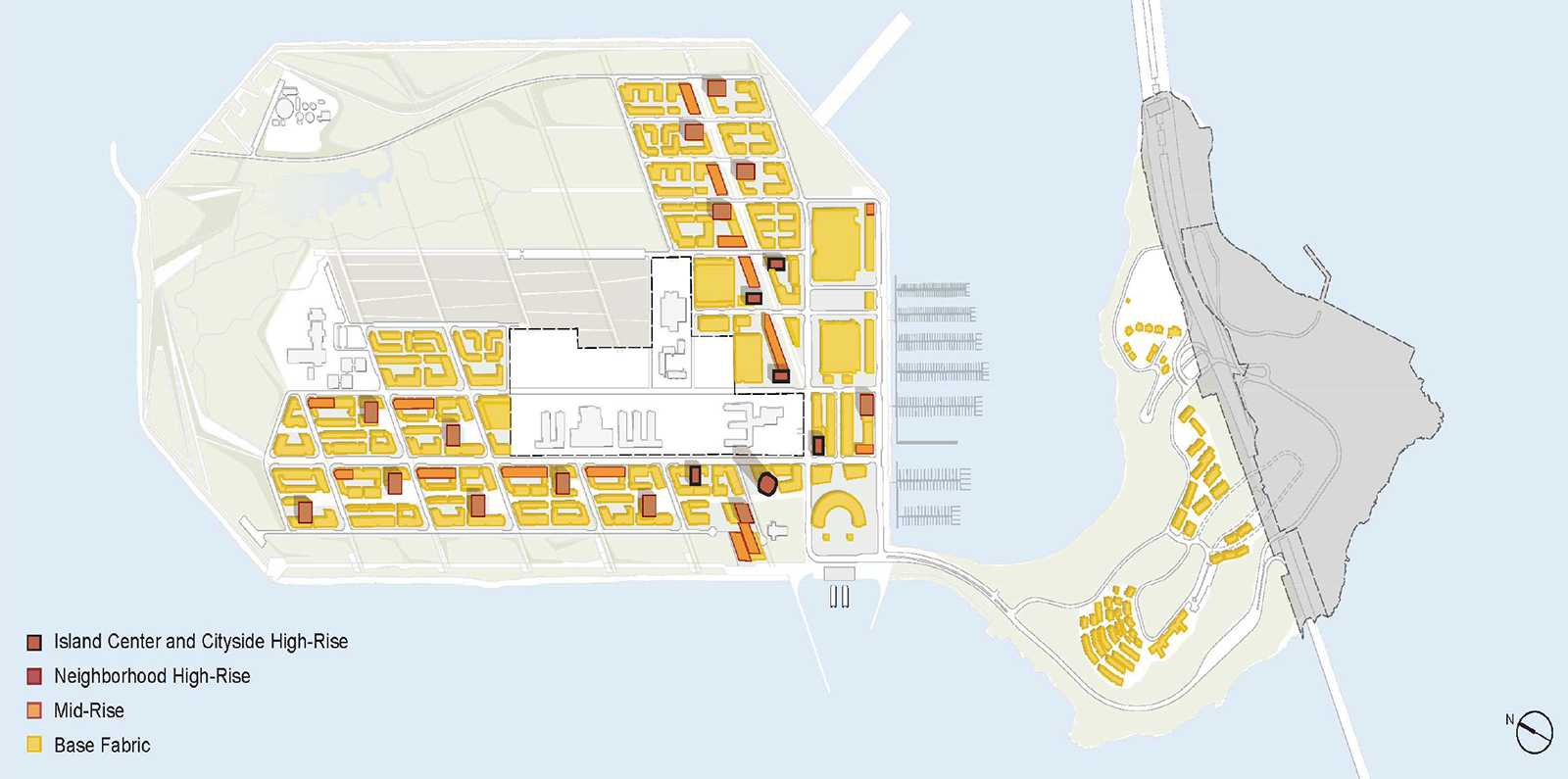
To assure visual interest, building sizes and types should be varied throughout. Dramatic shifts in urban form can serve to announce places of entry, culture, and history on the Islands. An overall design strategy should assure some variety of building sizes across each block, but also designate building heights and sizes by their relationship with the development’s districts, street hierarchy, and open space network. In general, on Treasure Island the tallest buildings should mark the Island entry and commercial mixed-use areas, stepping down towards the water and as the development moves out across the Island; taller prominent street walls should be featured along important streets and open spaces. However, special care should be given to the topography and habitat value of Yerba Buena Island which will dictate the placement and form of buildings. Buildings should reinforce the natural island topography, but also include pathways and stairs to provide links to the hilltop park. Building heights should relate to their adjacent street and open space widths and areas.
POLICY 2.7
Encourage taller buildings carefully interspersed throughout the neighborhoods as a way to mark important places, to efficiently concentrate development, to provide interest and variety in the cityscape, and to create an identifiable skyline.
Tall buildings (towers) enable the efficient use of land and allow increased density near transit and other supportive services; this encourages more residents to use alternative means of transportation other than a car. By enabling more density, towers make it possible to use more land for open space, retention of historic buildings and other community amenities. However, placement of towers should minimize wind and shadow on the public realm and maintain view corridors. Towers should be varied in height so as to uniquely define the skyline of Treasure Island in the middle of the Bay. The urban form that is created should be sensitive to the mass of Yerba Buena Island as well as the new Eastern Span of the Bay Bridge. Height and bulk controls should ensure the careful placement of towers so that the placement of the towers opens views and offers light and air, while not placing the towers too far from each other, which would diminish the urban form of the skyline.
Transportation and Circulation
OBJECTIVE 3
IMPLEMENT TRANSPORTATION IMPROVEMENTS THAT ARE MULTI-MODAL, SERVE RESIDENTS AND VISITORS, PRIORTIZE WALKING, BIKING AND TRANSIT, AND PROVIDE RESIDENTS WITH THE ABILITY TO COMMUTE AND MEET DAILY NEEDS WITHOUT HAVING TO DRIVE.
POLICY 3.1
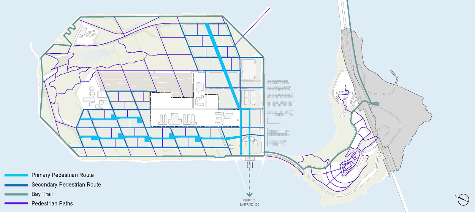
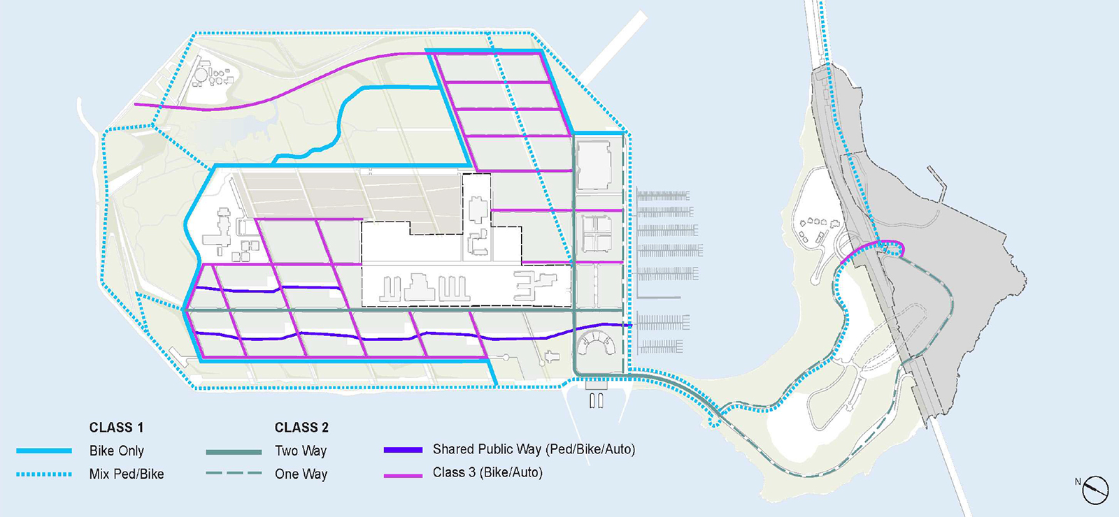
Develop a street pattern and design vocabulary on each island that responds to that particular location, while prioritizing the use of transit, walking, and biking over the use of private automobiles.
The hierarchy, pattern, and design of streets should reflect a commitment to a public realm designed first and foremost for pedestrians, bicyclists, and transit riders, while at the same time accommodating vehicular traffic. The streets should provide direct, safe, and interesting routes for biking and walking between the residential areas and the commercial core and transit hub.
On Yerba Buena Island, the street network should be more limited, responding to the steep topography, lower density development, and the need to minimize development of previously undeveloped areas. Within the existing street network, opportunities for access for transit vehicles, pedestrians, and bicyclists should be added.
Urban design of the Islands and street networks should facilitate inviting and easy travel on foot or by bicycle and street design should accommodate vehicular traffic at low to moderate volumes and speeds throughout the Islands. Streets should be designed to meet or exceed the standards and objectives of the City’s Better Streets Plan and should strive to reflect best practices. Development on the Islands should include diverse street types such as primary circulation routes, primary access connector streets, neighborhood streets and pedestrianfocused streets. Transit and street types should serve both residents of the Islands and visitors traveling to the Islands for recreational purposes.
POLICY 3.2
Create a regional central transit hub with ample and diverse transit service that is designed to facilitate the use of transit by residents and visitors alike. On-island pedestrian and bike mobility should be enhanced to access transit.
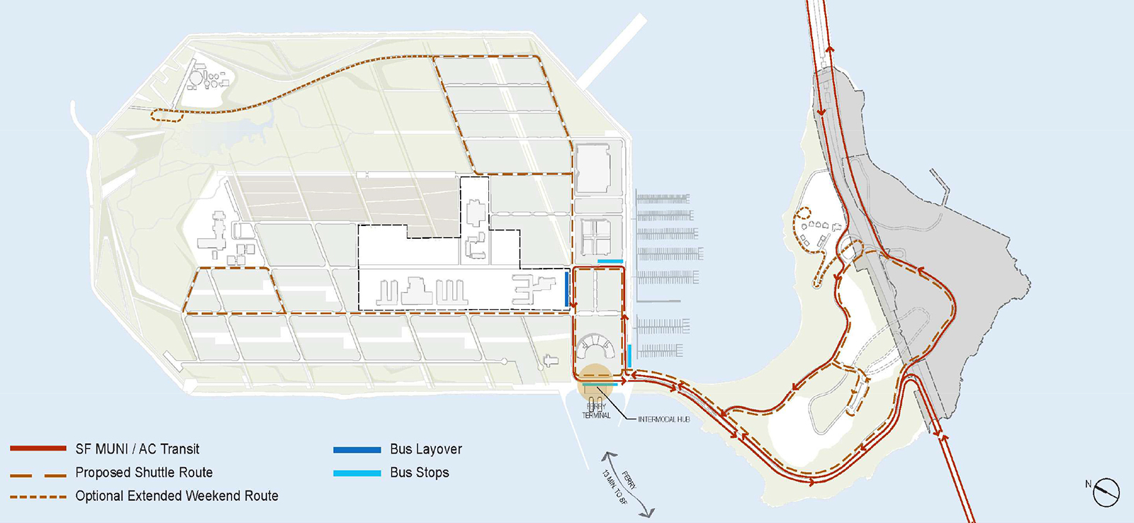
To ensure efficient coordination of transportation options on and off the Islands, new development should centralize transportation connections in a central attractive hub for transit. This facility should focus on both local on-island and regional off-island transportation connections, including new and expanded ferry and transbay bus services to both San Francisco and the East Bay. The transit hub should be designed with passenger ease and comfort in mind. The facility should be located conveniently to serve the greatest concentration of population on the Islands within walking distance and have direct and safe pedestrian and bicycle access to all parts of the Islands.
POLICY 3.3
Manage automobile parking on the Islands to encourage transit use by workers and visitors, to encourage visitors who drive to park once and move about the Islands primarily by foot, and to encourage residents to utilize pedestrian, bicycle and shuttle services. Minimize the impact of parking and loading on the public realm and circulation.
The priority for the development of the Islands should be to encourage the use of transit by residents and visitors alike. The amount of parking and vehicular traffic on the Islands should be minimized in quantity and actively managed to discourage driving, such as through pricing and by offering incentives for other ways of travel. Lots and garages should be strategically located to encourage visitors arriving by car to park and circulate through the Islands amenities either by foot, bicycle or the Island shuttle system. Off-street and accessory parking should minimize effects on the public realm and be integrated within building design. Bike parking and car-share programs should be encouraged. Off-street parking should be designed to facilitate access to key areas such as open space while minimizing conflicts with bicycles, transit and pedestrians. Standards and guidelines for freight loading should generally prohibit off-street loading and direct loading spaces to adjacent streets or access alleys, adjacent parking fields or off-street within the building being served.
POLICY 3.4
Identify Transportation Demand Management (TDM) measures to discourage the use of automobiles and encourages the use of bicycles, transit, and walking.
Development on the Islands should utilize TDM program strategies to reduce the amount of auto traffic within the Islands as well as accessing the Islands from the Bay Bridge, and to encourage residents, workers and visitors to use non-auto modes of travel, including transit, walking, and biking. A key component of the TDM program should be congestion pricing for vehicles accessing the Bay Bridge to encourage use of transit to and from the Islands and to discourage auto trips during peak times. A comprehensive transportation program should facilitate connections to both the East Bay and downtown San Francisco. As authorized by state legislation, a separate Treasure Island Transportation Management Agency should be established to oversee implementation of a congestion pricing program on the Islands and administer other transit programs focused on discouraging the use of private automobiles. New development also should include additional TDM measures such as car sharing, bicycle sharing, carpool programs, and selling or renting residential parking spaces separately from dwelling units to encourage more efficient and economic use of parking resources.
Economic Development
OBJECTIVE 4
CREATE JOBS, A VARIETY OF ECONOMIC DEVELOPMENT OPPORTUNITIES, AND COMMUNITY FACILITIES TO ENHACE VITALITY AND QUALITY OF LIFE FOR RESIDENTS OF THE ISLANDS AND THE CITY.
POLICY 4.1
Include commercial, office and community uses that will provide jobs at a wide range of fields, and at a wide range of income levels, including for those who are economically disadvantaged or formerly homeless.
The closing of Naval Station Treasure Island resulted in the loss of local jobs and economic opportunities that should be replaced through the redevelopment of Treasure Island. A mix of commercial uses should be provided to generate jobs at all levels of the spectrum. In particular, jobs should be targeted to economically disadvantaged and formerly homeless persons. The City should coordinate delivery of job-training programs with its existing workforce development infrastructure wherever possible.
POLICY 4.2
Create an appropriate mix of new businesses focused on job-generating uses and economic opportunities.
New development on the Islands should promote economic development through the creation of job-generating uses on the Islands. While construction job opportunities will be numerous during the long build out of the Islands, development also should ensure a wide range of end use and permanent job opportunities such as business and entrepreneurial opportunities, office and retail opportunities, and small business development. New parks and open space could also provide opportunities for employment in the operation, maintenance, and management of associated parks and facilities.
POLICY 4.3
Assure that the new development is financially self-sufficient.
Any new development should be structured so that the financing for development will not have a significant negative impact on the City's General Fund. Consideration should be given to land use densities and commercial uses that will be sufficient to generate revenues, increase property values, and support public vehicles that will make development financially viable and selfsufficient, help pay for transportation and other infrastructure improvements, and achieve other economic and public benefits.
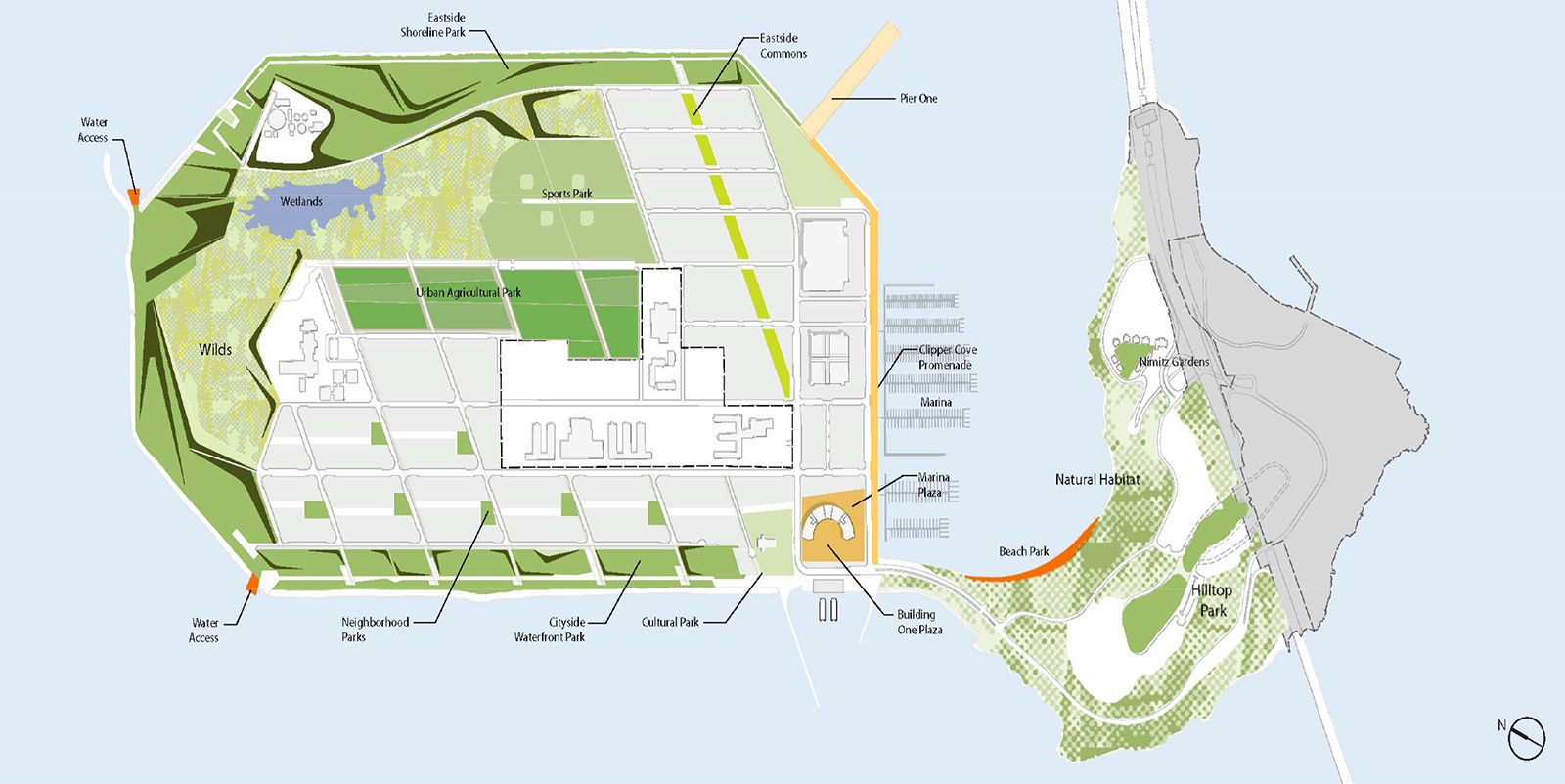
Recreation and Open Space
OBJECTIVE 5
CREATE A HIGH QUALITY SYSTEM OF PUBLC PARKS AND OPEN SPACE, FACILITATE IMPROVED SHORELINE ACCESS, AND PROVIDE A WIDE RANGE OF RECREATIONAL, EDUCATIONAL AND ECOLOGICAL RESTORATION OPPORTUNITIES.
POLICY 5.1
Provide a wide variety of types and scale of open space with an array of recreational and conservation opportunities that are integrated into the surrounding development and neighborhoods.
Proposed development plans should prioritize parks, open space, and recreational opportunities as both a key land use and as an amenity to serve other land uses. The open space system on the Islands should include a wide range of types of parks with diverse sizes, characteristics, and recreational amenities to meet the needs of the development, residents, and regional visitors. The open space network should include a variety of both active and passive recreational opportunities, shoreline parks, neighborhood parks, and cultural areas. The open space network also should enhance and complement other community facilities on the Islands, such as the sailboat launch, sailing center and school yard. Development also should include more neighborhood and community uses.
POLICY 5.2
Open space should be developed and managed in a way that increases waterfront public access and fulfills the objectives of the Public Trust.
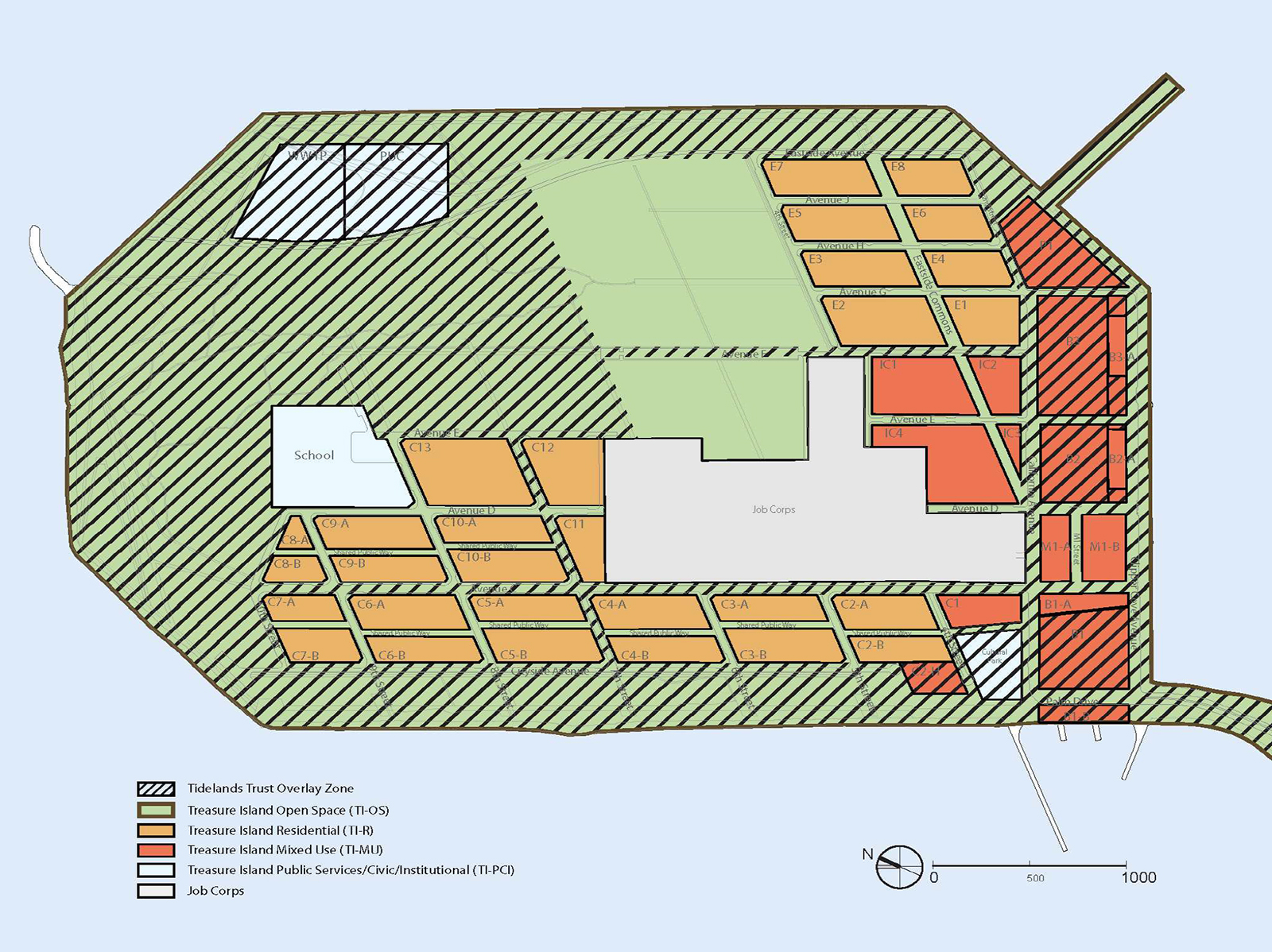
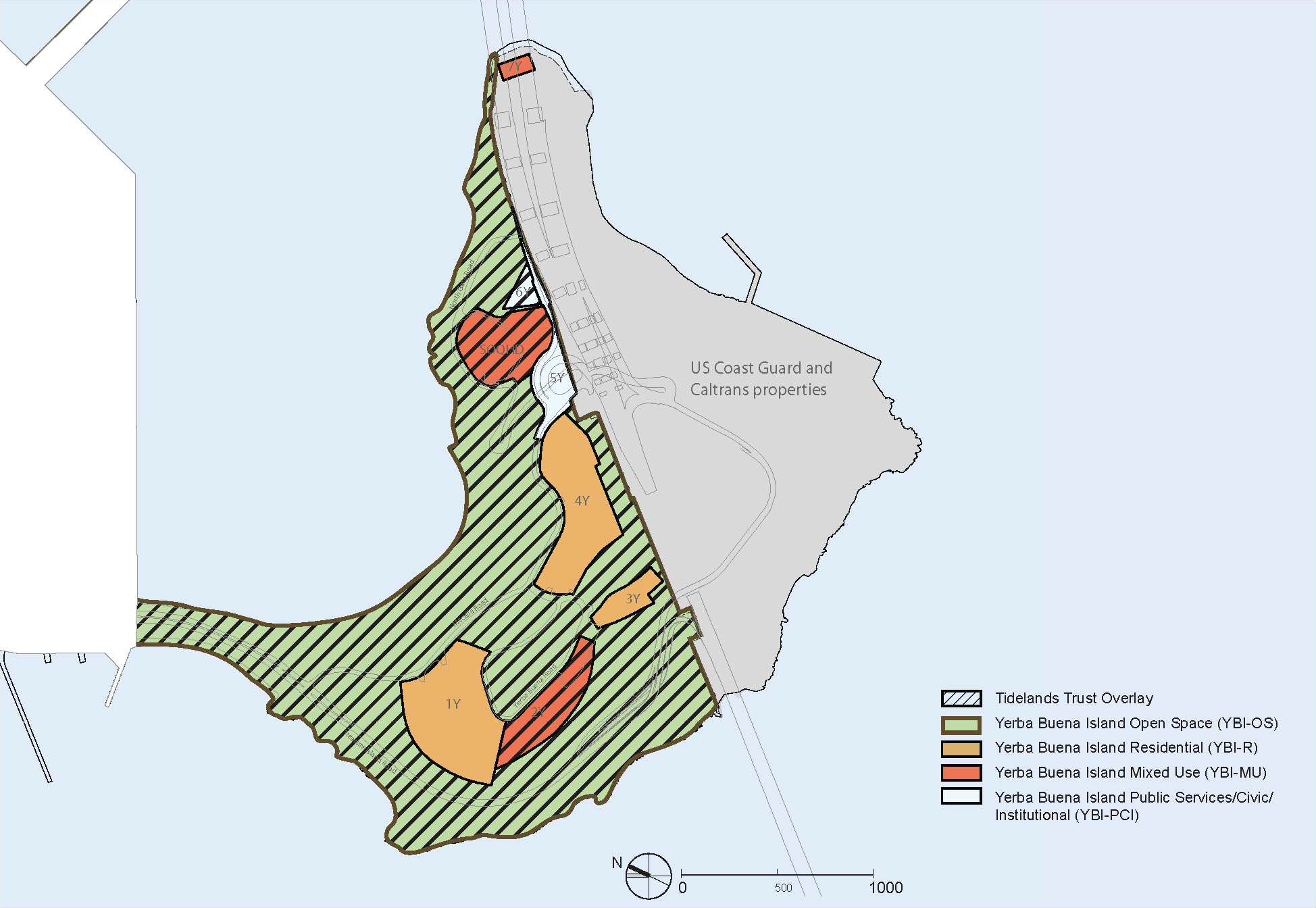
Proposed development plans should emphasize the unique Bay location of Treasure Island and Yerba Buena Island by providing increased waterfront and shoreline access consistent with regional planning principles and regulatory requirements. Visual and physical connections to waterfront parks and open spaces should be maintained in development areas. Parks and open space in the Public Trust areas must be designed so that their uses are consistent with the Trust. Lands on Treasure Island that may be subject to the Public Trust should be administered and reconfigured through an exchange with the State of California for lands of Yerba Buena Island that are not presently subject to the Trust, so as to allow the purposes of the Public Trust to be more fully realized on the Islands as a whole. The open space programming for both Islands should be consistent with the objectives of the Public Trust, including the principles of providing public access, habitat management and view enhancement.
POLICY 5.3
Recreational and educational opportunities that serve both the neighborhood and the region as a whole should be provided and increased as part of the Islands development.
A significant amount of lands on both Islands should be programmed for open space recreation that is accessible by residents of the Islands and the region.
Some open space facilities should focus on serving the needs of residents and workers in close proximity (walking distance) to all residential neighborhoods and development areas. Neighborhood parks and open spaces should provide facilities serving a range of community needs including playgrounds, informal recreation areas, flexible spaces for exercise and spaces for community and small group gatherings.
In larger open spaces and around the shoreline, programming should seek to serve regional needs for open space, water access, and sports facilities. The regional recreational program should also include natural areas for passive recreation, and opportunities for environmental education programs and urban agriculture.
POLICY 5.4
Support habitat conservation and bio-diversity through landscape design.
The open-space system also should provide opportunities for ecological restoration and habitat management initiatives and provide ecological services, such as storm water treatment. Yerba Buena Island is a natural island with existing native habitats that should be restored or enhanced where feasible. A habitat management plan for Yerba Buena Island should be created that guides the management of the open spaces. While Treasure Island is a constructed Island with little existing habitat value, portions of the new landscape should be designed to create habitat and support biodiversity.
POLICY 5.5
Provide for universal accessibility and create a highly-connected network of parks and open spaces.
Parks and open spaces should be connected to create a continuous network with excellent connections to regional transit and bike/pedestrian systems, including multi-use paths on the Bay Bridge. Neighborhood open spaces should be located within a short walking distance of all neighborhood residents and visitors and ensure that parks and open spaces are easily accessible by pedestrians, bicyclists, and transit. The parks and open spaces should be universally accessible, providing access to open spaces and park facilities.
Sustainability and Infrastructure
OBJECTIVE 6
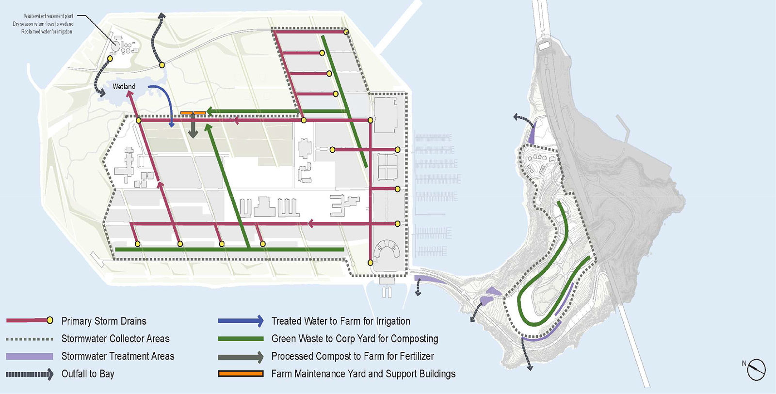
DEVELOP INFRASTRUCTURE THAT IS SUSTAINABLE IN THE SHORT- AND LONGTERM BY REDUCING THE USE OF ENERGY AND WATER, ALLOWING FOR INCREASED SUSTAINABILITY OVER TIME, AND BEING ADAPTABLE FOR CHANGES IN THE ENVIRONMENT DUE TO CLIMATE CHANGE.
POLICY 6.1
Design and build infrastructure that supports a high-density development while also recognizing the unique constraints of being located on an Island.
The infrastructure that exists on both Islands is in dilapidated condition. The opportunity exists to provide new infrastructure that is efficient and right-sized to minimize energy consumption and wastage. A high-density development footprint concentrated on a portion of the Islands would minimize the extent of infrastructure. Infrastructure design for the Islands should take into account the geotechnical aspects of a man-made island, provide for robust supplies of utilities supplemented by on-island storage and/or backup, and minimize the necessity to pump effluents for off-island treatment. To the degree feasible using cotemporary best practices, reduce, reuse, treat, and recycle waste streams on-island.
POLICY 6.2
Design and build neighborhood land plans and new development based on the best principles of sustainable design.
Proposed development plans should emphasize the unique Bay location of Treasure Island and Yerba Buena Island by providing increased waterfront and shoreline access consistent with regional planning principles and regulatory requirements. Visual and physical connections to waterfront parks and open spaces should be maintained in development areas. Parks and open space in the Public Trust areas must be designed so that their uses are consistent with the Trust. Lands on Treasure Island that may be subject to the Public Trust should be administered and reconfigured through an exchange with the State of California for lands of Yerba Buena Island that are not presently subject to the Trust, so as to allow the purposes of the Public Trust to be more fully realized on the Islands as a whole. The open space programming for both Islands should be consistent with the objectives of the Public Trust, including the principles of providing public access, habitat management and view enhancement.
POLICY 6.3
Develop a strategy that allows Treasure Island to be adaptively managed over the long term to protect against sea level rise.
With uncertainty over the potential amount of sea level rise, Treasure Island’s development should be designed to be adaptable. Strategies for protection against coastal flooding should take into account present day conditions, protect against a reasonable increase of sea levels balanced with goals for placemaking, public access and view enhancement, and maintain the ability to continue to adapt over the long term.
Plan adopted by the Board of Supervisors Ordinance No. 97-11 on 5/2/2011.