Hunters Point Shipyard Area Plan
INTRODUCTION AND PURPOSE
Hunters Point Shipyard is located in the southeast corner of San Francisco, approximately 1.3 miles northeast of the City and County line and approximately six miles south of Downtown. The shipyard itself is comprised of a largely flat 493 acre landfill peninsula. It is surrounding on three sides by water and is bordered on its land side be Hunters Point Hill.
The Hunters Point Shipyard served as a working naval shipyard between1941 and 1974. The closing of the Shipyard was a major blow to the Bayview; about 5,100 jobs were suddenly lost – an event from which the Bayview Hunters Point community hasn’t fully recovered The United States Navy ceased operations at the Shipyard in 1974 and officially closed the base in 1988. The Shipyard was then included on the Department of Defense’s 1991 Base Realignment and Closure (BRAC) list.
Planning for the Shipyard’s redevelopment has been a long and complex process. In 1993, following designation of the Shipyard by the City’s Board of Supervisors as a redevelopment survey area, the City and the Agency began a community process to create a plan for the economic reuse of the Shipyard and the remediation and conveyance of the property by the Navy. In 1997, after several years of community planning, the City and the Redevelopment Agency adopted the Hunters Point Shipyard Redevelopment Plan (Shipyard Redevelopment Plan) for the Shipyard and a Citizens Advisory Committee (CAC) was subsequently appointed. The CAC has been instrumental in guiding development at the Shipyard. One of the first actions they took was to establish general planning principles for the Shipyard which were developed through a number of public workshops and meetings. These principles have been incorporated into the goals and objectives outlined in this Area plan.
In March 2004, the Agency, in cooperation with the City negotiated a comprehensive agreement with the Navy governing the terms and conditions of the hazardous materials remediation and conveyance of the Shipyard by the Navy to the Agency (the “Conveyance Agreement”). The Conveyance Agreement obligates the Navy to remediate hazardous materials on the Shipyard to levels consistent with the land uses designated in the original redevelopment plans for the Shipyard Redevelopment Plan as adopted in 1997 and to convey parcels to the Agency at no cost on a phased basis as the Navy successfully completes the remediation.
In 2003, the Agency entered into the Hunters Point Shipyard Phase 1 Disposition and Development Agreement (“Phase 1 DDA”) with Lennar/BVHP Partners for the development of Parcel A on the Shipyard, which included the construction of infrastructure for up to 1,600 residential units, of which approximately 30% must be affordable and approximately 25 acres of public parks and open space. Parcel A was conveyed to the Agency by the Navy in 2005 and the Agency then closed escrow on its transfer of a portion of Parcel A to the Shipyard Developer under the terms of the Phase 1 DDA. A Design for Development document was also adopted. This development is currently underway and is widely referred to as Hunters Point Shipyard Phase I.
In May 2007, the Board of Supervisors adopted, and the Mayor approved a resolution endorsing a Conceptual Framework for the integrated development of Candlestick Point and the remainder of the Shipyard (Phase 2). The Conceptual Framedwork combined the planning and redevelopment of these two project areas to create a more coherent overall plan, including comprehensive public recreation and open space plans and integrated transportation plans. Combining the two areas into a single development effort also enabled better ways to increase efficiencies in financing affordable housing and the public infrastructure necessary to expedite the revitalization of both areas. The Conceptual Framework envisioned a major mixed-use project, including hundreds of acres of new waterfront parks and open space, thousands of new units of housing, a robust affordable housing program, extensive job-generating retail, research and development space, permanent space for the artist colony that exists in the Shipyard, and a site for a potential new stadium for the 49ers on the Shipyard.
In June 2008, San Francisco voters approved Proposition G, an initiative petition measure named The Bayview Jobs, Parks, and Housing Initiative, regarding plans to revitalize Phase 2 of the Shipyard and Candlestick Point. Proposition G: (i) adopted overarching policies for the revitalization of the Project site; (ii) authorized the conveyance of the City’s land in Candlestick Point currently under the jurisdiction of the Recreation and Park Department, for development in furtherance of the Project, provided that there is a binding commitment to replace the transferred property with other property of at least the same acreage that will be improved and dedicated as public parks or open space in the Project ; (iii) repealed Proposition D and Proposition F relating to prior plans for the development of a new stadium and retail entertainment project on Candlestick Point; and (iv) urged the City, the Agency and all other governmental agencies with jurisdiction to proceed expeditiously with the Project.
The purpose of this Area Plan is to outline broad General Plan objectives and policies to meet both the Bayview community’s desire to redevelop the Shipyard and Candlestick Point in accordance with the project envisioned in the Conceptual Framework and Proposition G. Maps and figures provided here, as well as within the Bayview Hunters Point Redevelopment Plan, shall serve as the General Plan maps for the Hunters Point Shipyard area.
Existing Conditions
As described above, Hunters Point Shipyard is largely comprised of a landfill peninsula of approximately 490 acres and five miles of shoreline. The historic geography of the area has changed dramatically: Hunters Point Hill originally stretched ½ mile into the Bay, meeting the waters edge with steep banks. The Shipyard today was created with fill at the end of the peninsula largely by removing portions of the hill. Today, the Shipyard is characterized by largely flat topography, meeting the shoreline with man-built wharves, piers, dry docks and sea walls. The central and most northern sections of the Shipyard, however, are on higher elevations partially a part of original hill geography.
The Shipyard includes upwards of 135 buildings associated with ship repair, piers, dry-docks and other former navy uses, largely from the World War II era. Only a few of the building remain occupied with the largest constituent being the 300 artists located in seven buildings. Most of the site is undergoing environmental clean-up by the Navy, and has controlled access.
Currently, the only way in and out of the Shipyard is via Innes Avenue, which connects the area to Third Street by way of Hunters Point Boulevard and Evans Avenue, through India Basin Shoreline, the neighborhood to the immediate northwest. There are other routes over Hunters Point Hill to Third Street and the rest of the City, but they are circuitous and not obvious choices. Crisp Road, on the northwestern side of Hunters Point Hill, does not currently allow through access.
The Shipyard is separated from Candlestick Point by Yosemite Slough and South Basin. Currently the only way to connect to Candlestick Point and neighborhoods further south and west is to transverse around the slough through the South Basin light industrial neighborhood.
Related Plans
The Bayview Hunters Point Area Plan
The Shipyard is not technically within the boundaries of the Bayview Hunters Point Area Plan (BVHP Plan), However, because of the Shipyard’s significance to the Bayview community, it is discussed throughout. The BVHP Plan addresses the Bayview as a whole in spelling out goals and priorities for ongoing community development. Themes discussed throughout the BVHP Plan includes arresting the demographic decline of the African American population; providing economic development and jobs, particularly for local residents; eliminating health and environmental hazards including reducing land use conflicts; providing additional housing, particularly affordable housing; providing additional recreation, open space, and public service facilities, and better addressing transportation deficiencies by offering a wider range of transportation options. While the BVHP Plan addresses some specific areas, most discussions are kept general and apply to the neighborhood as a whole. The BVHP Plan was updated in 2006 when most of the Bayview was incorporated into the Bayview Hunters Point Redevelopment Plan’s Project Area. The Shipyard is discussed within the BVHP Plan in the context of its potential to serve as an area to focus residential and mixed-use development that would also create jobs for the community. The BVHP Plan has been updated again subsequent to the adoption of the Candlestick Point Sub-Area Plan and this Area Plan.
Candlestick Point Sub-Area Plan
In accordance with the Conceptual Framework and Proposition G, Candlestick Point was also targeted for revitalization and development. By providing a potential new location for the stadium at the Shipyard, Candlestick Point could be freed up for more housing, retail, and other associated uses that would better benefit from its synergistic location next to Candlestick Point State Recreation Area. Even though a part of the same overall planning effort, a Candlestick Point Sub-Area Plan has been prepared separately in recognition that it is within a separate redevelopment plan area.
Summary
While a specific land use plan and design controls have been developed for Hunters Point Shipyard through Amendments to its Redevelopment Plan and associated Design for Development Document, the intent of this Area Plan is to distill planning principles that are reflected in these plans, and that relate back to other elements of the General Plan. As with other Area Plans, this plan provides broad planning parameters.
1. Land Use
OBJECTIVE 1
REALIZE THE FULL POTENTIAL OF THE UNDERUTILIZED HUNTERS POINT SHIPYARD BY CREATING A COMPLETE AND THRIVING NEW NEIGHBORHOOD INTIMATELY CONNECTED TO THE BAYVIEW AND THE REST OF THE CITY, IN A WAY THAT FULLY REALIZES ITS SHORELINE LOCATION AND ACTS AS AN ECONOMIC CATALYST FOR THE REST OF THE BAYVIEW.
POLICY 1.1
Create a balanced and complete mix of land uses.
Land use in San Francisco is to a large extent mixed use in nature. In such environments, neighborhood-serving retail, such as food stores, laundry services, and other sundry needs, are located adjacent to residential uses. Job-creating uses such as offices, workshops and institutions are also nearby providing residents opportunities to find employment in close proximity to their homes. Recreation and entertainment facilities are similarly interspersed throughout. Locating such uses in close proximity to each other makes life more convenient, decreases the need for car trips, and facilitates more use of the public realm in a more intimate and communal way. It is crucial that any new development be of similar mixed-use character. The mix of uses should facilitate daily life without an automobile, and should make it possible to meet a significant portion of daily needs on foot or by bicycle.
POLICY 1.2
Take full advantage of the underutilized site by providing high density sustainable development.
To create vital neighborhoods, it is also essential to assure density sufficient to support local retail and services and more robust transit service. Much of the Shipyard’s 490-acres, is currently comprised of blighted and obsolete development that was associated with the former Navy operations and has not been in use in many years. The opportunity to leverage high-density development for the revitalization of this underutilized land and at the same take advantage of the shoreline location.
Developing at high densities is more sustainable in general while at the same time enabling the efficient use of innovative green development construction strategies.
POLICY 1.3
Create a distinctive destination for the Bayview, the City, and the region.
The Shipyard’s approximately five-miles of undeveloped shoreline is an unparalleled asset. Locating the football stadium at the Shipyard would be a unique opportunity to create an iconic sports complex at the water’s edge, repeating for San Francisco football what AT&T Park did for San Francisco baseball. Any plan needs to provide the 49ers with a clear viable option for typical football season operations, but should more particularly, emphasize the extraordinary opportunity it represents. Special attention should be given on how to treat stadium parking, and the opportunities for the use of dual use turf in order to take advantage of the surface parking areas on non game days for active and passive recreation. Special attention also needs to be given how the stadium entry is treated relative to the streets and surrounding buildings and neighborhoods. However, development of the Shipyard should also consider other uses for the stadium site, should the 49ers not avail themselves to the opportunity to locate a stadium at the Shipyard. Any non-stadium alternative should also be consistent with the objectives and provisions of the Shipyard Redevelopment Plan and associated Design for Development document.
Also unique to the Shipyard is the existing artist community which is considered one of the most thriving communities of artists in the region. New development should seize on the opportunity to build on this asset as a way to create a vibrant neighborhood. Artist galleries and other similar artist-based retail could be an important component to retail and commercial development.
The history of the Shipyard and surrounding community should also be celebrated as part of the development, in particular within the public realm. Celebrating the Shipyard’s history is not only a worthwhile in its own right, it helps create a unique and special identity for new development adding overall value to the Shipyard and the Bayview neighborhoods.
The large expanse of undeveloped space also provides opportunities not practical in other areas of San Francisco and the region, such as the ability to accommodate focused campus-like development. In creating such development, care must be taken so that it does not take on the characteristics of typical suburban office development. Such development must be public in nature with its street grid and circulation connecting to the rest of the City; parking must be appropriately treated so as to avoid broad swaths of surface parking typical of suburban campus development.
POLICY 1.4
Ensure that new land uses will accommodate diverse residential, worker, and visitor populations.
POLICY 1.5
Acknowledge history as part of the land use and urban design plan.
The project should include uses that acknowledge the history of the original native American inhabitants of the Hunters Point area and historic relationship of Bayview Hunters Point’s African American community of the Shipyard and other communities with historic ties to the area.
A complete neighborhood must serve a wide variety of populations. Housing should serve a broad range of income levels, household size, and typology preferences. It should include housing for those at different stages of life, particularly for seniors, and consider housing for those with special needs. At the same time, the variety of housing types and populations served should be interspersed throughout as to avoid inadvertent spatial separation of residents of differing groups.
Similarly, employment opportunities should include jobs along the income spectrum. Any development will provide construction opportunities over a relatively long build out, however, development should include other permanent job opportunities including those in administrative, managerial, professional, maintenance, social entrapenurship and other positions. Any transit plan should consider how to get the new residential population efficiently to other clustered job centers including Downtown, Hunters Point Shipyard and regional transit that serves the Peninsula and East Bay in an efficient manner that will encourage the use of public transportation.
OBJECTIVE 2
WHILE DEVELOPING HUNTERS POINT SHIPYARD, ASSURE APPROPRIATE TREATMENT OF ARCHEOLOGICAL RESOURCES AND RESOURCES IMPORTANT TO NATIVE POPULATIONS AS UNIQUE, IRREPLACEABLE RECORDS OF THE PAST AND OF ONGOING CULTURAL SIGNIFICANCE.
San Francisco has the oldest and most complex archeological record of any major urban area in California. It’s archeological legacy is also a fragile, finite and non-renewable. San Francisco’s historical archeological record dates to 1776 and its prehistoric record dates to more than 5,000 years before the present. The archeological record is the only surviving remains of some peoples (for example, prehistoric peoples and historically marginalized peoples) and of some historical phenomena. Even when a parallel documentary record exists, the archeological record may preserve a less filtered and biased view of the past. Since the media, methodologies, and theoretical frameworks through which documentary history and archeology have access to the past are so different, the contribution of archeology to the history and prehistory of San Francisco provides a special and sometimes the only voice of the past to the present.
At the same time, prehistoric sites are valued for reasons beyond their ability to provide data about the past. Archeological sites may have significance as a traditional cultural property when associated with the cultural values or practices of living Native Americans, such as the Ohlones (Costanoans).
Where archaeological resources cannot be avoided during implementation of the Candlestick Point/Hunters Point Shipyard Phase 2 Project, consistent with the archaeological mitigation measures in the Candlestick Point/Hunters Point Shipyard Phase 2 EIR, archeological resources should be preserved through appropriate archeological treatment including data recovery, analysis, written interpretation, recordation, and curation of the archeological data that has significant research value. Moreover, special care must be given to assure sensitive treatment to such sites that are of cultural value to indigenous populations. Clear protocols should be used to engage relevant Native American groups on making decisions about such resources. Not only should such consideration be given to known possible archeological sites, but also in cases when such resources are inadvertently discovered.
2. Community Design & Built Form
OBJECTIVE 3
CREATE A DIVERSE AND EXCITING URBAN NEIGHBORHOOD THAT IS ENGAGING, COMFORTABLE, AND HAS CONVENIENT ACCESS TO AMENITIES, OPTIMIZES ITS WATERFRONT SETTING AND REFLECTS SAN FRANCISCO BUILT FORM AND CHARACTER IN A CONTEMPORARY WAY.
POLICY 3.1
Create a development that takes advantage of the shoreline location.
As an area surrounded on three sides by water, the primary urban design consideration must be its shoreline location. Care must be take to assure that shoreline open space is the focus of development.
POLICY 3.2
Ensure a block pattern and street network that relates to adjacent neighborhood, is coherent, and provides the development with organization and orientation.
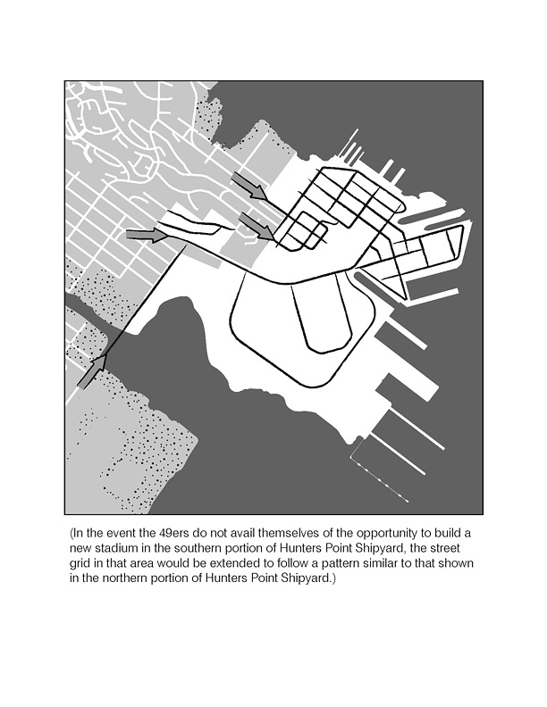
Essential to any new neighborhood is its relationship to surrounding neighborhoods. Because of the topography of the Hunters Point Hill, its atypical block pattern to San Francisco, and its further disconnection by the undeveloped nature of India Basin Shoreline, there is no adjacent street grid to tie into. However, as a means of organizing new development and making it feel like a San Francisco neighborhood, a typical street grid with typically laid out blocks should be utilized. Equally important to assuring such integration is incorporating the same streetscape improvements envisioned for new development into the existing neighborhood, thereby knitting the new and existing into a single neighborhood fabric.
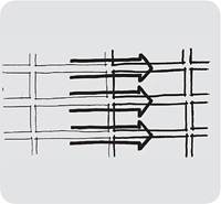
Extend existing neighborhood street grid into new development.
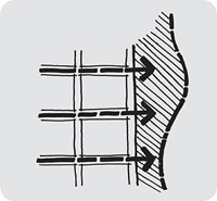
Enhance access to shoreline through extended grid.
Base new block pattern on BVHP block pattern. Further divide blocks to enhance pedestrian accessibility and comfort.
POLICY 3.3
Create a street system where streets are clearly an element of the public realm.
POLICY 3.4
Assure buildings meet the street in a way that defines the street’s three-dimensional space as well as activates and enlivens it.
It is through the public realm elements, such as, streets, sidewalks, building facades, adjacent small spaces, parks that people experience the city and that neighborhoods derive their uniqueness and sense of place. Streets are to be thought of more than a means of mobility; they are places in their own right. Building faces must be designed to accommodate activation of the street: residential streets must feature landscaping and setbacks to allow for street-facing patios, stoops and entrances; retail streets must be designed to have a continuous set of storefronts typical of San Francisco neighborhood commercial districts. Where other uses face the street, such as office and research and development uses, other design interventions that enliven the façade must by included.
POLICY 3.5
Provide a development with a variety of building heights and sizes as a means to create variety and avoid monotonous development.
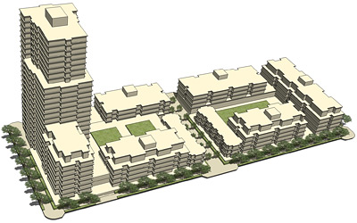
New development should include a wide variety of building types raging from townhouses to high rises. Blocks should be divided with mid-block alleys and pedestrian ways, and buildings should address the street.
The development of the new neighborhood has to be thoughtful in its phasing and eventual built-out. Because of the scale of Shipyard, overall development should be broken down into smaller districts with each having their own identity. Smaller districts are more manageable and legible and help in providing orientation.
To assure visual interest and avoid repetition, building sizes and types should be varied throughout. An overall strategy should assure some variety of building sizes across each block, but also designate building heights and sizes by their relationship with the development’s districts, street hierarchy, and open space network. In general, buildings should step down toward the water; taller prominent streetwalls should be featured along important streets and open spaces. Predominant buildings heights should relate to their adjacent street and open space widths and areas.
POLICY 3.6
Encourage tall buildings (towers) as a way to create an identifiable place, contribute to a variety of building forms, and efficiently use land.
Tall buildings (towers) enable the efficient use of land and put more people near transit and supportive services, thus helping assure their viability. By putting greater densities on less land, more land can be freed up for the public realm. Towers in and of themselves help create identity and can be used to mark particularly important locations within a neighborhood. However, care must be taken in deciding their locations. Towers must maintain public view corridors through the area by means of height and bulk controls that ensure carefully spaced slender towers. Placement of towers must also preserve adequate light and air and minimize wind and shadow on public streets and open spaces. While it is important that towers be spaced far enough from each other to avoid crowding out the sky, they must not be placed so far from each other as to loose an overall coherent urban form. Similarly, towers should be varied in height so that the skyline takes on a dynamic form rather than presenting a single “benched” height when seen from a distance.
POLICY 3.7
Assure high quality architecture of individual buildings that work together to create a coherent and identifiable place while being individually distinguishable.
Buildings and structures must not only work together to form a coherent whole, but should be individually attractive and distinguishable. Architects should be encouraged to be creative in meeting the sites’ programming needs within required development controls. Any development should incorporate sustainable technologies in innovative ways and express these technologies architecturally. All buildings must emphasize the human scale; while the Area Plan allows for large buildings, all buildings, regardless of their size, should be broken down vertically and horizontally so that they relate to the scale of the human body. The manner in which buildings meet the ground and the public realm is also crucial. Ground floor programming must directly address the adjacent street or public realm.
Quality materials and detailing will be extremely important to convey durability and permanence. Thoughtful application of materials and detailing is most crucial at the building base, where pedestrians experience the building close-up.
3. Transportation & Circulation
OBJECTIVE 4
INCLUDE TRANSPORTATION IMPROVEMENTS THAT ARE INHERENTLY MULTI-MODAL, ARE SEAMLESSLY CONNECTED TO THE BAYVIEW AND THE REST OF THE CITY, AND PROVIDE RESIDENTS WITH THE ABILITY TO MEET DAILY NEEDS WITHOUT HAVING TO DRIVE
POLICY 4.1
Create a neighborhood with a safe, legible, and easily navigable street network.
New streets and rights-of-way should be extensions of the existing neighborhood street network. A grid street pattern connects seamlessly to the existing network and offers travelers various choices of routes. Streets should be designed with the principles and objectives of the City’s Better Streets Plan (currently in draft form) in mind. Street design should emphasize pedestrian and bicyclist comfort and safety. Major routes to and from the Shipyard must serve pedestrians, bicyclists and transit riders, both for those traveling to specific destinations and for people who want to use streets for enjoyment and recreation.
POLICY 4.2
Emphasize multi modal transportation as an integral feature of the street network.
POLICY 4.3
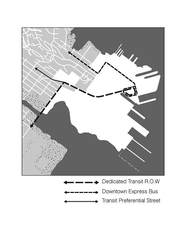
Include enhanced transit that will not only serve the new community but improve transit for the Bayview and surrounding neighborhoods as well.
All streets throughout the community should be planned for multi-modal use. Street design should stress alternatives to the automobile and facilitate easier movement for transit, bicycles and pedestrians. Dedicated right-of-way for either bus rapid transit (BRT) or light rail transit (LRT) should be a major feature in any street network. BRT right-of-way should be connected to a broader regional BRT system connecting to CalTrain, BART, and the Third Street LRT. BRT stations should be strategically placed in the new neighborhood next to destination locations such as the potential 49ers Stadium, Arts Center, and R&D Neighborhood. Enhanced transit service should be planned to not only serve new residents and workers, but also those in the surrounding communities as well.
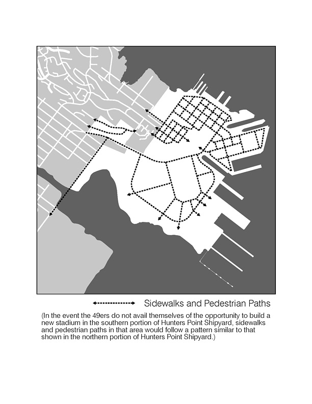
Beyond transit, a new development transportation strategy must focus on the pedestrian. The streets and adjacent buildings should be designed to ensure pedestrian comfort and interest. Sidewalk widths, street crossings, and ample street space dedicated to pedestrians will make traveling by foot easy and enjoyable. Land use patterns that provide clear destinations and short distances between supporting uses will help to make walking an obvious travel choice.
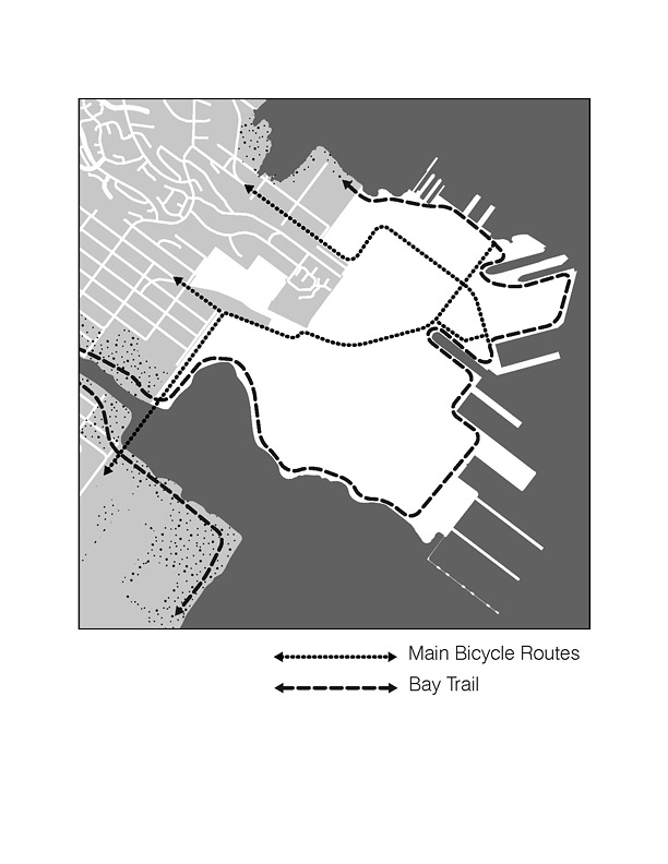
Facilitation of bicycle use is also important. The street network should accommodate travel by bicycle on most streets (excluding transit and freight routes) with particular routes indicated for special Class I and II treatment through the neighborhood. Planning for bicycles should include consideration for recreational use along the Bay Trail, efficient commuter bicycle routes connecting to existing City routes, and day-to-day use within the neighborhood.
POLICY 4.4
Identify Transportation Demand Management (TDM) measures to discourage the use of automobiles and encourages the use of bicycles, transit and walking.
An effective TDM program will reduce the amount of auto use and encourage residents, employees, and visitors to use alternative modes of travel, such as transit, walking and bicycling including at peak travel times. Such a program should be consistent with City policies and work withongoing plans for nearby developments. The core of TDM strategies are to ensure that the true cost of driving is realized. Strategies include: setting parking rates that accurately reflect their cost of construction and other externalities caused by driving; selling or renting residential parking spaces separately from the units so that they are less expensive for those who choose not to own a car; and encouraging more efficient and economic use of parking resources by prioritizing parking for shared parking, van pools, and other alternative means of transportation. Similarly, TDM programs should make using transit more efficient by providing a transit coordinator, and incorporating the cost of transit passes in HOA fees and as a part of employment compensation packages.
4. Economic Development
OBJECTIVE 5
CREATE JOBS FOR ECONOMIC VITALITY.
POLICY 5.1
Include commercial uses that will provide jobs at both a wide range of fields, and at a wide range of income levels.
POLICY 5.2
Support the local artists’ community.
POLICY 5.3
Create an appropriate mix of new businesses.
A major theme throughout the adjacent Bayview Hunters Point Area Plan is to promote economic development largely through the provision of new job-generating uses. New development at the Shipyard will provide numerous construction jobs. But it should also look to ensuring a wide range of permanent jobs. It is essential that land uses create employment, business and entrepreneurial opportunities, cultural and other public benefits for Bayview and other San Francisco residents. Sufficient land should be set aside to provide diverse job-creating uses, such as research and development, light industrial, and office activities; and create opportunities for private entrepreneurship and small business development. The newly created parks and open space network should also provide opportunities for ongoing employment in open space maintenance and management.
In anticipation of the new construction and permanent jobs provided by new development, the City should incorporate job-training and job-preparedness programs for Bayview and other City residents. The City should partner with developers and community-based organizations on workforce programs to best meet employment needs of local residents and utilize it’s existing workforce development infrastructure to ensure that local Bayview residents will be able to access the job opportunities created by the project. Similarly, land use programming should set aside space for local entrepreneurs and incubator activities.
OBJECTIVE 6
IN CREATING A NEW NEIGHBORHOOD, PRODUCE TANGIBLE ECONOMIC COMMUNITY BENEFITS, AND ENSURE THAT THE NEW DEVELOPMENT ACTS AS A CATALYST FOR FURTHER ECONOMIC AND COMMUNITY DEVELOPMENT THROUGHOUT THE BAYVIEW AND THE CITY.
POLICY 6.1
Assure that the new Hunters Point development is financially self sufficient.
Any new development should be structured so that the financing for development and operation of the Project will not have a negative impact on the City’s General Fund. Consideration should be given to land use densities and commercial uses that will be sufficient to generate revenues to make development financially viable and self-sufficient, help pay for transportation and other infrastructure improvements, and achieve other economic and public benefits.
5. Recreation & Open Space
OBJECTIVE 7
CREATE A WORLD CLASS SYSTEM OF OPEN SPACE THAT INCLUDES A SIGNIFICANT PORTION OF THE OVERALL HUNTERS POINT SHIPYARD, ENABLES IMPROVEMENTS THE SHORELINE ENHANCES ACCESS, PROVIDES A WIDE RANGE OF RECREATIONAL AND ECOLOGICAL RESTORATION OPPORTUNITIES, AND IS SEAMLESSLY INTEGRATED WITH THE EXISTING NEIGHBORHOOD.
POLICY 7.1
Provide a wide variety of types and scale of open space with a wide variety of recreational and conservation opportunities.
Any proposed development plan should emphasize open space and recreational opportunities. The open space system should consist of a wide variety of parks, with diverse sizes, characters and programs, including neighborhood and community parks, grassland ecology parks, waterfront promenades and opportunities for sports and active recreation. It should include both large scale spaces suitable for large events, and more intimate gathering spaces essential for a living and working neighborhood. New open space and parks should orient visitors to the neighborhood and waterfront and serve the recreational needs of residents in both the new and existing adjacent communities. The park system should also provide ecological services, such as storm water and habitat management. Additionally, lands granted to the Agency by the State of California that are subject to the Public Trust should be administered and reconfigured in a manner consistent with the public trust for commerce, navigation and fisheries and enhances their value for public trust purposes, in accordance with Chapter 203 of the Statutes of 2009 (“Granting Act”).
POLICY 7.2
Celebrate the history of the site, including the history of indigenous populations, by incorporating interpretive elements throughout the development.
Hunters Point Shipyard has a rich and layered history, which should be expressed and celebrated throughout the development. Opportunities should be explored to celebrate the history of the Naval Shipyard, pre-Naval maritime and fishing activity, the African American community’s settlement of Bayview and Hunters Point Hill, and the history of Native American populations. Community members close to different aspects of the Shipyard’s history should be invited to participate in planning commemorative elements in the streetscape, open space, public art or other community-related facilities.
Hunters Point Shipyard Area Plan adopted by Planning Commission Resolution 18098 on 06/03/2010, and Board of Supervisors Ordinance 0203-10 on 08/03/2010.
Amendments by Board of Supervisors Ordinance 0164-18 Adopted on 07/10/2018.