Rincon Hill Area Plan
INTRODUCTION
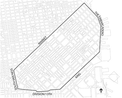
This is a plan for the emergence of a new mixed-use neighborhood on Rincon Hill, a twelve-block area close to downtown. Rincon Hill is south of the Financial District and Transbay District, and north of the South Beach neighborhood. It is bounded generally by Folsom Street, the Embarcadero, Bryant Street, Beale Street, the Bay Bridge approach and Essex Street.
The area is defined by the hill itself, which crests near First and Harrison Streets; the Bay Bridge, near the southern edge of the district between Harrison and Bryant Streets; and the waterfront, which curves around the base of the hill. This area is highly visible because it forms a gateway to the city as seen from the Bay Bridge and is prominently located adjacent to downtown and the waterfront. The district currently houses many parking lots, older industrial lots, as well as a few recently built residential buildings.
The Rincon Hill Plan aims to transform Rincon Hill into a mixed-use downtown neighborhood with a significant housing presence, while providing the full range of services and amenities that support urban living. This plan will set the stage for Rincon Hill to become home to as many as 10,000 new residents.
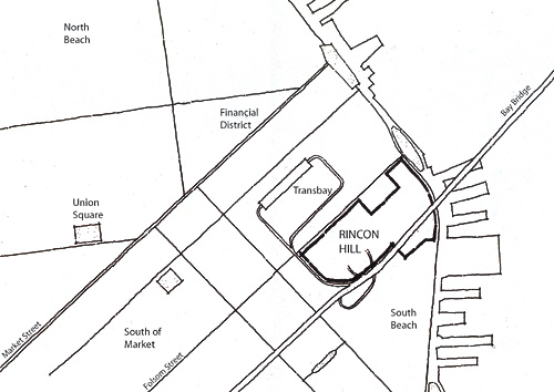
Figure 1: Vicinity Map
The need for new housing in San Francisco is great. Rincon Hill is a high priority housing site for the following reasons:
-
The area contains a number of large vacant or underutilized parcels that could accommodate a large number of housing units in mid-rise and high-rise development. Few locations in the city represent such a major opportunity.
-
The land is presently underused. Thus, introduction of major new housing development will not cause many disruptive dislocations or harm the physical quality of an existing neighborhood.
-
Rincon Hill is a five minute walk from the financial district. It has easy access to public transit and has benefited from the Rincon Point-South Beach redevelopment project on the southeastern waterfront, particularly the construction of the Waterfront Promenade along the Embarcadero, and will benefit from the Transbay redevelopment project to the north of Folsom Street.
-
With the removal of the Embarcadero Freeway and the proposal for a new Transbay Terminal, there is an opportunity to plan comprehensively for the Transbay district and Rincon Hill together as one neighborhood centered on Folsom Street.
Before such new development can occur, however, several distinctly negative features of Rincon Hill must be addressed. The Rincon Hill Area Plan sets forth a process by which presently underused industrial land now devoid of the intimate qualities of neighborhood life can be transformed into a desirable new place to live in San Francisco.
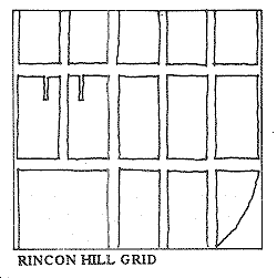
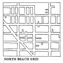
The existing industrial character of Rincon Hill is reinforced by the geometry of its street grid. Rincon Hill has very wide streets and long, uninterrupted blocks, in contrast to the complex, fine-grained pattern of streets in older downtown neighborhoods such as North Beach and Russian Hill. Rincon Hill’s streets are unsafe and unpleasant for pedestrians—sidewalks are narrow, intersection crossings dangerous, and few active uses line the sidewalk edge. Creation of a more residentially scaled street pattern on Rincon Hill is a major goal of this plan.
Rincon Hill is also lacking in open space, community facilities and neighborhood commercial uses that allow people to walk to take care of their daily recreation, shopping and other needs. This plan calls for creating these elements as part of a comprehensive neighborhood plan.
Finally, recent development has done little to enhance the neighborhood environment. In recent years, Rincon Hill has seen the construction of bulky, closely-spaced residential towers, which block public views, crowd streets, and contribute to a flat, unappealing skyline. These developments have also contributed little to the pedestrian environment, with multiple levels of above-ground parking, and garage entries and featureless walls facing the street. This plan sets clear development standards and design guidelines that will result in buildings that positively contribute to the neighborhood and the cityscape.
The Rincon Hill Plan incorporates a strategy through which public policy can induce private capital to transform an unattractive and underused environment into an attractive, mixed-use residential neighborhood. This is a plan to be acted upon by the infusion of private capital. Public investments that have been added in the form of adjacent residential and waterfront amenities as part of the South Beach-Rincon Point redevelopment project and the remaking of the Embarcadero as a grand boulevard and recreational promenade provide an added stimulus for private development. It is expected that private development will provide the capital funding for the neighborhood improvements called for as part of this plan, through a variety of funding mechanisms, independent of direct public funding sources.
VISION FOR A NEW NEIGHBORHOOD IN RINCON HILL
The new Rincon Hill neighborhood is envisioned with buildings from 45 to 85 feet in height, punctuated by slender high-rise residential towers, spaced to allow light and air to streets and maintain an airy feeling to the skyline. A variety of open spaces, ranging from public parks, plazas and pedestrian pathways to private roofdecks, terraces and porches, will be ample and interspersed throughout the district. Building service functions, loading, and parking will be set away from the street or underground.
Neighborhood-serving retail will be concentrated along Folsom Street as the heart of the Rincon Hill and Transbay neighborhoods, and the district’s north/south streets will be lined with individual townhouse units with front stoops and landscaped setbacks. Main, Beale and Spear Streets, extending all the way through Rincon Hill and Transbay, will be improved as “living streets,” with reduced traffic lanes and significantly widened sidewalks featuring usable open spaces and areas for both passive and active recreation. The open space network will feature a new large open space at the corner of Harrison and Fremont Streets, and community recreation uses included as part of a rehabilitated Sailor’s Union of the Pacific building.
Figure 2: Development Concept for Rincon Hill
Rincon Hill: Past and Present
History
European settlement of San Francisco first occurred in 1769. By the mid 1830s, areas of habitation included the Presidio, Mission and the pueblo of Yerba Buena at Yerba Buena Cove. The first expansion of San Francisco southward into Rincon Hill did not take place until the American Occupation in 1846. A further impetus was the Gold Rush in 1849. Prior to 1846, hunting and picnicking were the main activities on the hill. With the advent of the American Occupation, however, Rincon Hill became the location of a government military reserve with a battery of 32 lb. cannons.
The influx of gold seekers of 1849 brought forth the development of much of Rincon Hill and the surrounding waterfront. During the mid 1800s Rincon Hill roughly included the area between present day Third, Spear, Folsom and Bryant Streets. The shoreline before 1850 is estimated to have been 300 feet to the east of Rincon Hill. Construction in the area occurred concurrently with the filling of the tide shores beginning in the 1850s and continuing for 30 years.
Due to its sunny climate, views and topography, during the 1850s and 1860s Rincon Hill was particularly attractive as a residential area for the merchant and professional class. Mansions, carriage houses and stables dominated Rincon Hill. Rincon Hill was considered quite fashionable. Families of sea captains and shipping merchants as well as foreign nobility lived on the hill. The area was said to have had a similar feeling and flavor as such eastern seaboard villages as Nantucket and Martha’s Vineyard.
At the same time housing was being constructed, the maritime industry was also developing along the area’s waterfront, resulting in the construction of wharves, commercial rows, seafarers services, retail centers and industrial development on and around the hill.
One of the buildings noted as significant of that time was the Sailor’s Home, a very early landmark of the area. This building was located on the tip of old Rincon Point between Spear and Main Streets facing Harrison Street and the Bay. It was built in 1852, first serving San Francisco as the United States Marine Hospital, then as a seamen’s home, and finally as a home for the poor. In the 1870s it was a place for the “indigent or sick”, and as the turn of the century passed, Captain Jack Shickell recalled, “The old Sailor’s Home stood on Rincon Hill, but was run by the City and no longer for the exclusive use of seamen.” The 1919 Sanborn Maps indicate that the former Sailor’s Home successively became a Cooperative Employment Bureau, a woodyard, and again a home for the poor.
In 1869, to provide better access to the wharves and industries along Mission Bay, a major street reconstruction, the Second Street Cut, was undertaken by the City. This public works project literally divided Rincon Hill and created raw edges which led to the eclipse of Rincon Hill as a fashionable site for the homes of San Francisco’s middle and upper classes. The final blow to Rincon Hill as a residential neighborhood, however, was not to come until the tumult of April 18, 1906.
The 1906 San Francisco earthquake and fire leveled the neighborhood. As the city was reconstructed, new building methods and cable cars enabled people to live in the hills above Market Street and in other parts of the city. After 1906, Rincon Hill was slow to rebuild. The only people who made their homes in Rincon Hill immediately after the earthquake were workers and seamen. Their self-built shacks made of refuse lumber, packing boxes and sheet iron dotted the slopes of Rincon Hill. Authorities debated for years whether the rest of the hill should be leveled to provide for better access to the docks, warehouses, and industrial sites.
When the San Francisco-Oakland Bay Bridge was completed in 1936, the squatter shacks disappeared. The South of Market area (including Rincon Hill) became an important regional distributing center. Many wholesalers and warehousers took advantage of its location, which was close to the port, the rail network and the central district of the Bay Region’s largest city and next to a bridge connection with the growing East Bay area.
South of Market (including Rincon Hill) grew in importance as a distribution center until after World War II, when shipping modes went from rail to truck. Break-bulk operations became less important as cargoes were containerized. Competition from Oakland and other ports further reduced San Francisco’s ship trade. As transportation-related activities left, vacancies were filled by warehouses, storage, distributors, government services and other uses not as dependent on the port.
Existing Land Use
Rincon Hill contains approximately 55 acres of land, including streets and other rights-of-way. The area is subdivided into over 70 parcels, which are both publicly and privately-owned.
At the time this plan is adopted, Rincon Hill, like many South of Market Districts, is undergoing major transitions. These neighborhoods need comprehensive attention and land use guidance to transform them from a largely haphazard assortment of vacant lots, warehouses, back offices, and unrelated residential developments into a real urban place: supportive of urban living and with a safe and attractive public realm of streets, open spaces and pedestrian ways. With the removal of the Embarcadero Freeway and planning for the Transbay Redevelopment Area, this plan and new controls can help to create substantial new housing and to transform the district into a full-service neighborhood.
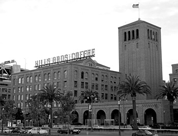
The brick-faced Hills Brothers Coffee building and the associated residential tower dominate the lower portion of the hill. Rising westward up the hill between Folsom and Harrison are some modern residential towers, some state and federal office/warehouse facilities, a formerly federally-owned office warehouse, and a few surface parking lots.
As the hill crests, there are several buildings operated exclusively for seamen, a living remnant of the hill’s history. These include two unions, a union hiring hall, and a residence and dining hall that once provided temporary shelter for seamen and is now a homeless shelter. Interspersed are light manufacturing, parking, and office uses. A number of residential tower developments have been recently constructed in the district. Between First and Essex Streets the area is divided by two smaller streets, Guy Place and Lansing Street. This area contains residences of a more traditional San Francisco neighborhood style and scale.
The blocks to the south of Harrison Street, nesting under the Bay Bridge, contain a mixture of new residential development, parking, light industrial uses, and vacant lots, including many state-owned lots.
OBJECTIVES AND POLICIES FOR NEW DEVELOPMENT AND CONSERVATION
The following objectives and policies apply to all future development and public improvements in Rincon Hill.
1. Land Use
OBJECTIVE 1.1
ENCOURAGE THE DEVELOPMENT OF A UNIQUE DYNAMIC, MIXED-USE RESIDENTIAL NEIGHBORHOOD CLOSE TO DOWNTOWN, WHICH WILL CONTRIBUTE SIGNIFICANTLY TO THE CITY'S HOUSING SUPPLY.
OBJECTIVE 1.2
MAXIMIZE HOUSING IN RINCON HILL TO CAPITALIZE ON RINCON HILL'S CENTRAL LOCATION ADJACENT TO DOWNTOWN EMPLOYMENT AND TRANSIT SERVICE, WHILE STILL RETAINING THE DISTRICT'S LIVABILITY.
OBJECTIVE 1.3
CREATE SPACE FOR ADDITIONAL USES TO PROVIDE NEEDED SERVICES FOR THE RESIDENT POPULATION BY TRANSFORMING FOLSOM STREET INTO A WALKABLE NEIGHBORHOOD CENTER TO SERVE THE RINCON HILL AND TRANSBAY NEIGHBORHOODS.
OBJECTIVE 1.4
ALLOW EXISTING INDUSTRIAL, SERVICE AND OFFICE USES TO REMAIN BUT REQUIRE ANY MAJOR REDEVELOPMENT TO INCORPORATE HOUSING.
OBJECTIVE 1.5
ADD LIFE AND ACTIVITY TO THE DISTRICT'S PUBLIC SPACES BY PROVIDING ACTIVE USES ON STREET-FACING GROUND FLOORS.
POLICIES
Residential
Rincon Hill will become a primarily residential neighborhood. The basic vision for development in Rincon Hill is of mid-rise podium buildings of 45 to 85 feet in height with ground-level townhouses opening directly onto the street, punctuated by slender residential towers. This development form would create a range of unit types to serve all family sizes and incomes. A limited amount of office use would also be permitted. In order to encourage the maximum amount of housing to contribute to the city’s housing supply, while still creating a livable neighborhood, the following policies apply:
POLICY 1.1
Allow housing as a principal permitted use throughout the district.
POLICY 1.2
Require six net square feet of housing for every one net square foot of non-residential use, and permit only residential uses above 85 feet in height.
POLICY 1.3
Eliminate the residential density limit to encourage the maximum amount of housing possible within the allowable building envelope.
POLICY 1.4
Require parking to be located primarily underground so that the allowable above-ground building envelope can be used for housing.
POLICY 1.5
Require street-facing residential units on the ground-floor on Spear, Main, Beale, Fremont, First, Guy Place and Lansing Streets, and encourage them on Harrison and Bryant Streets.
POLICY 1.6
Retain a zoning designation that allows for multiple uses for parcel 3769/001, owned by the Port of San Francisco.
It is not possible presently to develop housing on Port lands because of a restriction established as part of the State Public Trust that governs the use of Port lands.
Neighborhood Commercial
Folsom Street will become the neighborhood commercial heart for the Rincon Hill and Transbay neighborhoods. Folsom Street is envisioned to be a grand civic boulevard, with a consistent 45 to 85-foot streetwall, and ground-floor neighborhood retail along its length on both sides of the street.
POLICY 1.7
Require ground-floor retail use along Folsom Street for no less than 75 percent of all frontages.
2. Housing
OBJECTIVE 2.1
PROVIDE QUALITY HOUSING IN A PLEASANT ENVIRONMENT THAT HAS ADEQUATE ACCESS TO LIGHT, AIR, OPEN SPACE AND NEIGHBORHOOD AMENITIES, AND THAT IS BUFFERED FROM EXCESSIVE NOISE.
OBJECTIVE 2.2
ENCOURAGE NEW HOUSING PRODUCTION THAT MEETS A VARIETY OF HOUSING NEEDS, ESPECIALLY AFFORDABLE HOUSING.
OBJECTIVE 2.3
ENCOURAGE NEW HOUSING PRODUCTION OF AN ADEQUATE SIZE AND CONFIGURATION TO SERVE FAMILIES.
OBJECTIVE 2.4
PRESERVE EXISTING HOUSING UNITS ON GUY PLACE AND LANSING STREET.
POLICIES
This plan seeks to maximize the amount of housing that can be built in the district, to help relieve the city’s chronic housing shortage and to capitalize on Rincon Hill’s central location with regards to employment centers and transit service.
The desire to maximize housing must be balanced with the desire to create a livable neighborhood. Creation of the amenities of a pleasant housing environment should be the central feature of new development in the area. The open space and streetscape improvements and the various controls on building form and design proposed as a part of this plan are necessary to provide neighborhood scale and character appropriate for a residential district.
One existing environmental characteristic — noise — requires special attention. Portions of Rincon Hill are quite noisy. Sound levels near the bridge and freeways exceed State and City land use compatibility standards for housing. These regulatory standards are based on average noise exposure in a 24-hour period. In such a setting, occasional noises such as trucks ascending on-ramps at night, become even more irritating and can become a public health hazard.
To address the problem of high noise levels, noise reduction measures for individual buildings should be established and evaluated through the environmental evaluation process, and mitigated through appropriate building technologies.
Housing Affordability
Because Rincon Hill has little existing and older housing stock, there is little to no affordable housing currently within the district. In order to create a mixed-income district in the manner of traditional San Francisco neighborhoods, the following policies regarding housing affordability apply:
POLICY 2.1
Require all new developments of 10 or more units in the Rincon Hill district to meet the City’s affordable housing requirement of at least 12 percent on-site or 17 percent off-site, regardless of whether a Conditional Use permit is required.
POLICY 2.2
Require that inclusionary housing be built within the South of Market district, in areas designated for the encouragement of new housing. See Map 5.
POLICY 2.3
Develop publicly owned lands with 100 percent affordable housing.
Several parcels in the district are owned by public agencies. In the event that these agencies deem them excess to their needs or otherwise choose to dispose of them, the City should partner with non-profit housing developers in acquiring these sites and providing new residential development that is 100 percent affordable, per the Mayor’s Office of Housing and Affordable Housing Guidelines. See Map 6.
This plan’s development model will lead to a substantial number of units located in podiums and in street-fronting townhomes. These podium and townhome units afford greater access to both private and public open spaces and to the life of the street, making them appropriate for families with children. As they are cheaper to construct than tower units, they can also be more affordable. Affordable and family units must also be integrated into towers with market-rate units.
POLICY 2.4
Require 40 percent of all units in new development to be two or more bedroom units.
POLICY 2.5
Establish a target that 10 percent of all units in new development be three or more bedroom units.
Guy Place and Lansing Street
Guy Place and Lansing Street contain a number of housing units in the more traditional San Francisco walk-up style. These units should be retained for their special character and potential for greater affordability. These two streets contain examples of the residential character that the plan seeks to enhance and extend in the townhome portions of new development.
Guy/Lansing Neighborhood
3. Urban Design
OBJECTIVE 3.1
Achieve an aesthetically pleasing residential community.
OBJECTIVE 3.2
Develop a distinctive skyline form for Rincon Hill that compliments the larger form of downtown, the natural landform, and the waterfront and the Bay, and responds to existing policies in the Urban Design Element.
Figure 3 - Rincon Hill on the San Francisco Skyline
OBJECTIVE 3.3
Respect the natural topography of the hill and follow the policies already established in the Urban Design Element that restrict height near the water and allow increased height on the top of hills.
OBJECTIVE 3.4
Preserve views of the bay and the Bay Bridge from within the district and through the district from distant locations, which are among the most impressive in the region.
OBJECTIVE 3.5
Maintain view corridors through the area by means of height and bulk controls that insure carefully spaced slender towers rather than bulky, massive buildings.
OBJECTIVE 3.6
ENSURE ADEQUATE LIGHT AND AIR TO THE DISTRICT AND MINIMIZE WIND AND SHADOW ON PUBLIC STREETS AND OPEN SPACES.
OBJECTIVE 3.7
Reduce the present industrial scale of the streets by creating a circulation network through the interior blocks, creating a street scale comparable to those in existing residential areas elsewhere in the city.
OBJECTIVE 3.8
Encourage a human scale streetscape with activities and design features at pedestrian eye level, and an engaging physical transition between private development and the public realm.
OBJECTIVE 3.9
Minimize the visual impacts of residential parking, loading, utilities and services on the neighborhood.
OBJECTIVE 3.10
Relate the height and bulk of podium buildings to the width of the street, to define a consistent streetwall and ensure adequate sun and sky access to streets and alleys.
OBJECTIVE 3.11
Preserve and enhance the character and scale of finely-grained residential areas within the Rincon Hill area.
POLICIES
In guiding the character of a new high-density neighborhood on Rincon Hill, there are two different scales of urban form that affect the experience of the district for a pedestrian or resident:
-
Towers, which influence the immediate experience for a pedestrian in the district through their arrangement and form, and affect the city’s skyline and views of and through the district; and
-
Podium and ground-floor treatments, which define the immediate place for pedestrians and create activity and interest at the street level.
Towers
Height, bulk, and tower spacing controls are essential means of meeting the design objectives relating to towers. The number, arrangement and form of towers in the district determine the amount of light and air that reach residential units, streets, and open spaces, and the sense of crowding at street level. Rincon Hill will be a primarily residential district, not an office district, and the presence of towers must be tailored to support a living environment.
Additionally, Rincon Hill serves as a gateway to the city from the Bay Bridge and will have a prominent place on the skyline as viewed from many public vantages. Development on the hill will affect views from the bridge and the freeways, and views of the bridge.
The height and bulk of specific development projects should conform to the following design policies:
POLICY 3.1
Cluster the highest towers near the top of the hill with heights stepping down as elevation decreases. The overall form should identify Rincon Hill as a distinctive geographic feature on the city skyline, distinct from the downtown high-rise office core.
POLICY 3.2
Vary tower heights to avoid the visual benching created by a number of buildings whose tops are at the same elevation.
POLICY 3.3
Minimize tower bulk to the dimensions shown in Figure 4, to ensure a feasible tower floorplate, to create elegant, slender towers and to preserve views and exposure to light and air. In recognition of a new housing project at 525 Harrison Street, tower spacing less than 115 feet to a minimum of 82 feet and tower bulk in excess of the bulk control dimensions shown in Figure 4 may be permitted to encourage the provision of housing on this site keeping with the overall goals of this plan, provided that the other urban desing and planning polices of the plan are met.
POLICY 3.4
Require towers to be spaced no less than 115 feet apart, the maximum plan dimension per Figure 4 for towers over 85 feet in height, to minimize shadowing of streets and open space, and to preserve at least as much sky plane as tower bulk. In recognition of a new housing project at 525 Harrison Street, tower spacing less that 115 feet of a minimum of 82 feet and tower bulk in excess of the bulk control dimensions shown in figure 4 may be permitted to encourage the provision of housing on this site in keeping with the overall goals of this plan, provided that the other urban desing and planning policies of the plan are met.
In recognition of pipeline housing projects at 375 and 399 Fremont Street, tower spacing less than 115 feet to a minimum of 80 feet may be permitted to encourage the provision of housing on these sites in keeping with the overall goals of this plan, provided that the other urban design and planning policies of the plan are met.
POLICY 3.5
Allow no more than three towers per block, to optimize exposure to light and air from residential units, streets and open spaces.
In recognition of pipeline housing projects at 375 and 399 Fremont Street, up to four towers on Assessor’s Block 3747 may be permitted, to encourage the provision of housing on these sites in keeping with the overall goals of this plan, provided that the other urban design and planning policies of the plan are met.
POLICY 3.6
Sculpt tower tops to allow for architectural elements and to screen mechanical equipment.
POLICY 3.7
Maintain and reinforce views of the Bay Bridge and views of downtown as seen from the Bay Bridge.
POLICY 3.8
Step the height of buildings down approaching the Embarcadero so as to acknowledge the meeting of land and water.
POLICY 3.9
Minimize shadows on streets, open spaces and residential units, and the creation of surface winds near the base of buildings.
Figure 4: Bulk Controls
Podium and Ground Floor
The podium and ground-floor portions of new development create the most immediate experience of a building for a pedestrian, and create activity and interest at street level. Podiums and ground floors should be designed in such a way as to encourage pedestrian use and neighborhood safety through greater activity on sidewalks and on front stoops, and to minimize blank or blind frontages. To this end, the following policies apply to the podium and ground-floor portions of Rincon Hill development.
POLICY 3.10
Provide a consistent 45 to 85 foot streetwall to clearly define the street. See Map 7 for appropriate podium heights for each location within the district.
POLICY 3.11
Require building setbacks at upper-stories for podiums above 65 feet on Spear, Main, Beale, Fremont and First Streets, and above 45 feet on Guy and Lansing Streets and mid-block pedestrian pathways, per Figure 5, to preserve an appropriate scale and sun access to streets.
POLICY 3.12
Preserve lower podium heights in the Guy/Lansing area where there is an established pattern of four- to six-story buildings.
POLICY 3.13
Require ground-floor retail use along Folsom Street for at least 75 percent of the street frontage.
POLICY 3.14
Require street-facing ground floor residential units articulated at intervals of no more than 25 feet on Spear, Main, Beale, Fremont, First, and Lansing Streets, and Guy Place, except at tower lobbies or where parking access and utilities are necessary. Encourage them on Harrison and Bryant Streets.
POLICY 3.15
Require front setbacks of at least five feet on average in new development to allow for front porches, stoops, terraces and landscaping for ground floor units, and to establish a transition from public to private space.
POLICY 3.16
Restrict parking access to new buildings to two lanes (one egress, one ingress) of no more than 11 feet each, and loading access to one lane of no more than 15 feet. Parking and loading should share access lanes wherever possible.
POLICY 3.17
Require that all parking must be located below street grade. For sloping sites with a grade change of greater than ten feet, require that no less than 50 percent of the parking must be below grade, and any portions not below grade must be lined by active uses.
POLICY 3.18
Prohibit parking and loading access off of Folsom Street.
POLICY 3.19
To encourage the provision of housing on smaller sites in keeping with the overall goals of this plan, the Planning Commission may find the two pipeline housing projects at 375 and 399 Fremont Street that have filed conditional use application prior to March 1, 2003 consistent on balance with the General Plan without complying with Policies 3.1 through 3.18, provided that the other planning policies of the plan are met.
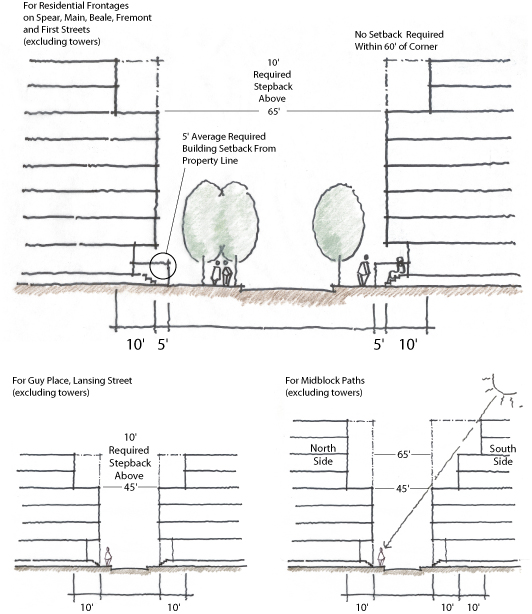
Figure 5: Required Stepbacks on Streets, Alleys and Mid-Block Passageways
4. Recreation, Open Space, and Community Facilities
OBJECTIVE 4.1
Create a variety of new open spaces and community facilities for active and passive recreation to meet the needs of a significant new residential population.
OBJECTIVE 4.2
CREATE A NEW NEIGHBORHOOD PARK TO SERVE THE DISTRICT.
OBJECTIVE 4.3
Link the area via pedestrian improvements to other public open spaces such as the waterfront promenade at the foot of the hill and planned open spaces in the Transbay district.
OBJECTIVE 4.4
ENSURE ADEQUATE SUNLIGHT AND MINIMIZE WIND AND SHADOW ON PUBLIC STREETS AND OPEN SPACES.
OBJECTIVE 4.5
Use excess street space on Spear, Main, and Beale Streets for sidewalk widenings that provide usable open spaces and recreational amenities.
OBJECTIVE 4.6
Create an inviting and pleasant mid-block pedestrian corridor to the waterfront.
OBJECTIVE 4.7
Require private development to contribute to the creation and on-going maintenance and operations of public open spaces and community facilities through in-kind contribution, a community facilities district, and/or developer fees.
OBJECTIVE 4.8
Ensure that there are adequate school facilities to serve existing and future residents of the Rincon Hill and Transbay neighborhoods.
POLICIES
Public Open Space System
The open space network for Rincon Hill will feature a variety of new open spaces, including a new two-acre park at the corner of Harrison and Fremont Streets, recreational ‘Living Streets’ that connect to the district’s other open spaces, and community facilities in a rehabilitated Sailor’s Union of the Pacific building.
By bringing several thousand new residents to the district, new development will create a need for greater open space in the district that must be offset by the creation of new public open space and community facilities. Private development must contribute funding to create public open spaces and community recreation facilities.
Map 8 shows the proposed Rincon Hill Open Space System, described in the following policies.
POLICY 4.1
Purchase parcels of adequate size for a neighborhood park. Parcels that should be prioritized for acquisition include 009, 010, 011, and 018 of Block 3766, at the southeast corner of Harrison and Fremont Streets, currently owned by CalTrans, and Parcel 005 of Block 3749, on Guy Place, currently a privately-owned vacant lot. Other parcels within the district may also be considered for a neighborhood park if a park of adequate size that is useable for Rincon Hill residents would be feasible on those sites.
The CalTrans parcels may also be suitable for joint development, with housing on the southern portion of the site and public open space in the northern portion, if the design results in improved public open space of a useable size for a neighborhood park.
POLICY 4.2
Significantly widen sidewalks by removing a lane of traffic on Spear, Main, and Beale Streets between Folsom and Bryant Streets per the Rincon Hill Streetscape Plan in order to create new “Living Streets,” with pocket park and plaza spaces for active and passive recreational use, decorative paving, lighting, seating, trees and other landscaping.
The Transbay Redevelopment Plan will continue the Living Street concept north of Rincon Hill, providing a continuous pedestrian promenade from the Financial District south to the Embarcadero.
POLICY 4.3
Create publicly accessible open space along Essex Street, including the hillside and useable space at the top of the hill.
Essex Street should receive similar treatment to the district’s other “Living Streets,” with a widened and landscaped east sidewalk and pocket parks, per the Rincon Hill Streetscape Plan and the Transbay Redevelopment Plan. This 25-35 foot-wide linear open space should be conjoined with landscape and stairway improvements on the Essex Street hillside, space for dogs, an overlook and sitting area at the top of the hill along Guy Place, and streetscape improvements on Guy Place and Lansing Street.
POLICY 4.4
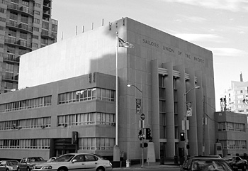
Include community recreation, arts and educational facilities as part of a rehabilitated Sailor’s Union of the Pacific building.
The Sailor’s Union will retain ownership of the building and use of space it currently needs. However, there is approximately 20,000 square feet of existing vacant space not being used by the Sailor’s Union, including an auditorium, gymnasium space, and some offices and workshops. The City should make arrangements such that currently vacant space be improved and made available for community use.
POLICY 4.5
Continue to look for additional sites for acquisition and development of open space in the Rincon Hill district.
Developer Contributions to Public Open Space
New development should help fund additional new services and amenities, including parks and community facilities, in proportion to the need for these services and amenities generated by new development. A variety of funding and implementation mechanisms will help to create these new public spaces, and to maintain and operate them over time independent of direct public funding sources.
POLICY 4.6
Create a community facilities district to fund capital improvements, operation and maintenance of new public spaces, including the Living Streets, the Harrison/Fremont park, and community spaces in the Sailor’s Union of the Pacific building.
POLICY 4.7
Require new development to implement portions of the streetscape plan adjacent to their development, and additional relevant in-kind contributions, as a condition of approval.
Private Residential Open Space
In addition to public open space, residential open space should also be provided to serve residents of new development.
POLICY 4.8
Require new development to provide private open space in relation to a development’s residential area at a ratio of 75 square feet of open space per unit.
POLICY 4.9
Allow up to 50 percent of private open space requirements to be provided off-site, provided that this space is publicly accessible. Off-site open spaces should adhere to and implement the Rincon Hill Streetscape Plan.
5. Streets and Transportation
OBJECTIVE 5.1
Create safe and pleasant pedestrian networks within the Rincon Hill area, to downtown, and to the Bay.
OBJECTIVE 5.2
Widen sidewalks, reduce street widths, and make other pedestrian and street improvements, while retaining the necessary space for traffic movements, per the Rincon Hill Streetscape Plan.
OBJECTIVE 5.3
Prioritize pedestrian safety through street and intersection improvements, especially at intersections adjacent to freeway ramps, and intersections with a history of vehicle/pedestrian collisions.
OBJECTIVE 5.4
Improve transit service to and from Rincon Hill.
OBJECTIVE 5.5
Manage parking supply and pricing to encourage travel by foot, public transportation, and bicycle.
OBJECTIVE 5.6
IMPROVE LOCAL AND REGIONAL TRAFFIC FLOWS AND TRANSIT MOVEMENTS BY SEPARATING BRIDGE-BOUND TRAFFIC FROM LOCAL LANES IN APPROPRIATE LOCATIONS.
OBJECTIVE 5.7
Maintain the potential for a Bay Bridge bicycle/pedestrian/maintenance path, and ensure that all options for the path touchdown and alignment are kept open.
OBJECTIVE 5.8
Encourage state agencies to allow the re-opening of Beale Street under the Bay Bridge as soon as security concerns can be met.
OBJECTIVE 5.9
Require private development to contribute to the creation and on-going maintenance and operations of special streetscapes through in-kind contribution, a community facilities district, and/or developer fees.
POLICIES
Policy 5.1
Implement the Rincon Hill Streetscape Plan.
The Rincon Hill Streetscape Master Plan calls for extensive sidewalk widenings, tree plantings, street furniture, and the creation of new public spaces along streets throughout the district. The plan describe specific curb and sidewalk changes and roadway lane configurations. New development in the plan area is required to implement portions of the streetscape plan as a condition of approval, and to pay into a community facilities district that will enable the City to implement and maintain those portions of the Streetscape Plan not put in place by new projects.
The Streetscape Plan contains the following changes to the existing Rincon Hill street system. Map 9 shows the streetscape concept, but not specific curb, sidewalk, and roadway changes.
Living Streets
Main, Beale and Spear Streets have low volumes of traffic most of the day and are needlessly wide. Creation of more intimate, residentially-scaled streets will help change the industrial character of the Hill and will serve the needs of the new residential population.
POLICY 5.2
Significantly widen sidewalks by removing a lane of traffic on Spear, Main and Beale Streets between Folsom and Bryant Streets per the Rincon Hill Streetscape Plan in order to create new “Living Streets,” with pocket park and plaza spaces for active and passive recreational use, decorative paving, lighting, seating, trees and other landscaping. See Figure 6.
Living Streets prioritize streets for pedestrian activity and open space over auto traffic, providing a variety of open spaces in significantly widened sidewalks, up to 32 feet on one side. The Transbay Redevelopment Plan will continue the Living Street concept north of Rincon Hill, providing a pleasant walk from the Financial District south to the Embarcadero.
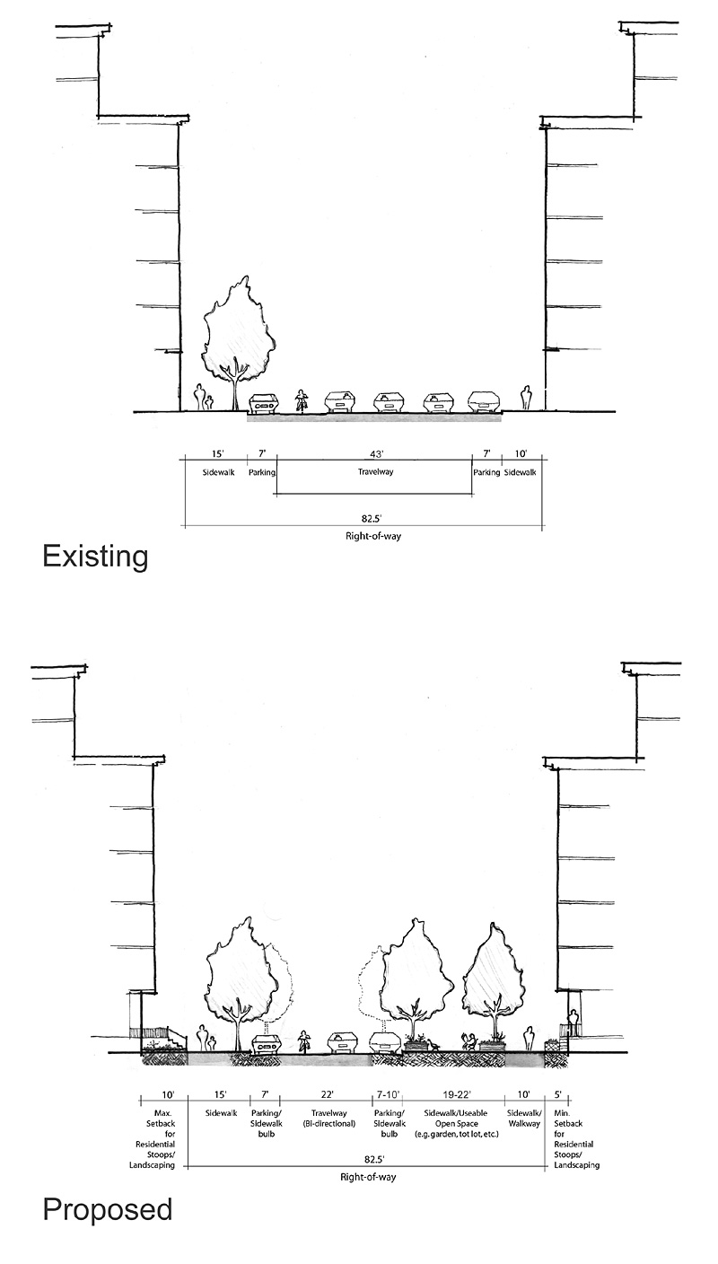
Figure 6: Proposed Living Street Section (Spear, Main and Beale Streets)
Folsom Street
POLICY 5.3
Transform Folsom Street into a grand civic boulevard, per this plan and the Transbay Redevelopment Plan.
Lined with neighborhood-serving retail, restaurants, and services, Folsom Street will be the commercial heart of the Transbay and Rincon Hill neighborhoods, and the civic and transportation spine linking the neighborhood to the rest of the South of Market and the waterfront. Folsom Street is not within the boundaries of the Rincon Hill Plan and changes to it will not be incorporated into the Rincon Hill Streetscape Plan; however, this plan supports the recommendations for Folsom Street contained in the Transbay Redevelopment Plan.
Harrison, First and Fremont Streets
POLICY 5.4
Widen sidewalks, narrow lanes and remove lanes, where feasible, on Harrison, First and Fremont Streets.
POLICY 5.5
Separate bridge-bound traffic from local traffic and transit through physical design strategies such as planted medians.
Harrison, First and Fremont Streets all carry heavy traffic connecting to the Bay Bridge. At the same time, there are opportunities to widen sidewalks and narrow overly wide lanes, and on Fremont Street, to take out a northbound lane. Medians and other physical design strategies should be used to separate bridge-bound traffic from local traffic and transit.
Guy Place and Lansing Pedestrian Street
POLICY 5.6
Implement streetscape improvements on Guy Place and Lansing Street that prioritize pedestrian use for the entire right-of-way.
Traffic volumes are very low on Guy Place and Lansing Street, largely because they form a closed loop. Because of the low traffic volumes, the “Shared Street” is an appropriate model for Guy Place and Lansing Street. The Shared Street prioritizes residential and pedestrian functions over regular provision for traffic. Such a facility provides a meandering streetscape which appeals to pedestrians with special landscaping and street furniture. It is intended to provide vehicular and pedestrian access to residences in the immediate vicinity and to serve as a place where residents can enjoy open space.
The physical design of Guy Place and Lansing Street should reinforce the very slow speed of the street, at which mingling of people and vehicles is safe, and encourage open space use by residents. The design will signal to drivers that they should expect to encounter people in the street. Existing on-street parking and driveway access should be maintained.
Mid-Block Pedestrian Pathways
POLICY 5.7
Ensure the creation of a safe, inviting, and pleasant publicly accessible pedestrian/open space mid-block pathway through Assessors Blocks 3744-3748 from First Street to the Embarcadero by requiring new developments along the alignment of the proposed path to provide a publicly-accessible easement through their property.
A new east-west pedestrian circulation system should be created in the middle of the long blocks between Folsom and Harrison Streets. These pathways will provide a pedestrian route from First Street near the top of the hill to the Embarcadero Promenade on the waterfront, and break up the scale of large blocks. The pathways would be connected by mid-block crossings on Spear, Main, and Beale Streets. Many of these pathways are already built or approved as part of development projects.
Map 9 shows the approximate location of the pedestrian pathway network.
Transit
There is limited intra-city transit service that currently serves Rincon Hill. As daytime and evening population increases, transit services will need to be established and enhanced to serve Rincon Hill. Walking will be the primary way that people living in Rincon Hill will move about for daily needs due to the immediate proximity of the downtown core, regional transit hubs at the Transbay Terminal, Market Street, and the Ferry Building, and the development of a neighborhood retail center focused on Folsom Street. However, better transit service is needed for Rincon Hill residents, employees, and visitors to access other San Francisco neighborhoods and for other San Franciscans to access Rincon Hill.
POLICY 5.8
Explore the feasibility of and implement if feasible the following transit improvements for Rincon Hill.
Short-term
- Extend the existing #1 California and/or the #41 Union bus at least one block south to Folsom Street
- Increase service on the existing #12 Folsom and #10 Townsend
- Add late night (owl) service to the area.
Long-term
These proposals are recommended for long-term consideration as part of a broader effort for the growing downtown neighborhoods South of Market, and to serve the dense Rincon Hill/Transbay area.
- Create Bus Rapid Transit in the Folsom Street corridor, including dedicated transit lanes, special stops, and traffic signal priority.
- Ensure a Rincon Hill/Transbay subway stop on Folsom Street for the proposed Geary Boulevard subway, should that potential subway line extend south of Market Street and under Folsom Street.
Parking
In accordance with the City Charter’s Transit-First Policy, the parking and loading requirements described below manage the siting and provision of parking to encourage travel by foot, bicycle and transit, while meeting the on-site parking and loading needs of new development. By managing supply and access, the parking and loading requirements described below support the creation of an active, walkable, and affordable neighborhood in Rincon Hill that capitalizes on its proximity to downtown and to nearby transit. These controls minimize curb cuts and blank frontages on important pedestrian streets, encourage viable alternatives to driving, and ensure that above-ground space is used for housing and other neighborhood-serving uses, rather than for parking. The controls also encourage the storing of cars for occasional or weekend use, rather than for daily commuting.
POLICY 5.9
Eliminate the minimum off-street parking requirement for all uses.
POLICY 5.10
Permit parking up to one space per two units by right, and up to one car per unit, provided that any parking spaces above one space per two units are not independently accessible.
POLICY 5.11
Permit parking for office use up to 7 percent of the gross leasable area, and for retail uses greater than 5,000 square feet up to one space per 1,500 square feet of occupiable floor area.
POLICY 5.12
Require that parking be sold or rented separately from residential units and commercial spaces in perpetuity.
POLICY 5.13
Require that parking will only serve those uses for which it is accessory in perpetuity, and under no circumstances will be sold, rented or otherwise made available as commuter parking.
POLICY 5.14
Prohibit parking as a principal use.
POLICY 5.15
Require new development over 50 units to offer at least one parking space to a car-sharing organization for the right of first refusal.
POLICY 5.16
Require parking for bicycles at a ratio of one space per two units for buildings with 50 units or fewer, and one space per four units for buildings with greater than 50 units.
6. Preservation
OBJECTIVE 6.1
Preserve and adaptively reuse those buildings in the area which have particular architectural or historical merit or which provide a scale and character of development consistent with the plan.
OBJECTIVE 6.2
Rehabilitate the Sailor’s Union of the Pacific building so that it may be used for publicly-accessible community recreation, arts and educational facilities.
The existing architecture of Rincon Hill is predominantly industrial in character, encompassing a wide spectrum of styles and building types. As was the case in manufacturing districts throughout the city, buildings were set on large lots with little regard for their neighbors. In the 1930s, the construction of the Bay Bridge and James Lick Freeway contributed to the further fracturing of the industrial area.
Despite the apparent randomness of the existing streetscapes, several buildings command particular interest. The great facades with their large window expanses — the result of a need for ambient light — and innovative massing plans illustrate a series of developments in industrial architecture. From the calm severity of the Hathaway Warehouse, one of the oldest of such structures in San Francisco, to the bold polychromatic lines of the Union 76 Building, a wide variety of architecture is represented. While factories and warehouses originated as severely utilitarian buildings, those of the late nineteenth and early twentieth centuries show a more deliberate attempt at a stylistic treatment. In some cases, the facades are as formal as those of office buildings in their articulation by a strict order of piers and symmetrical compositions. The use of reinforced concrete structural systems also permitted greater freedom in the choice of cladding material as well as in the application of decorative detail.
POLICIES
While most of the land within the Rincon Hill area is suitable for new development, there are a number of buildings that have been rated to be Significant Buildings based on their architectural and historical attributes and their preservation should be encouraged. (See Map 10 for location of specific sites.)
Since 1985, a number of these buildings have been rehabilitated and adapted for new uses, including the Hills Brothers Coffee Building, the Joseph Magnin Warehouse, the Hathaway Warehouse, the Coffin-Reddington Building, and the Gimbel Brothers Candy Factory. This plan further calls for the creation of funding to rehabilitate the Sailor’s Union of the Pacific Building.
The following guidelines should be applied in reviewing development on the sites of these buildings.
|
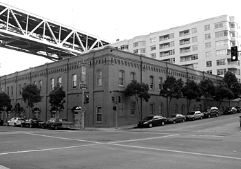
Site 1 — Sailors Union of the Pacific: 450 Harrison Street. The Sailors Union of the Pacific is a monumental granite block with two separate compositional sections. While the building’s two wings are characterized by long horizontal window bands, the central section is essentially a great concrete block with an enframed window wall entrance. A series of six concave piers, connected by wave panels and banded tubing, frames the tall vertical windows of the entrance. The grey facade walls surrounding this design are blank. The facade, designed by William Gladstone Merchant, bears a marked resemblance to his “Pacific House”, the theme building of the 1939-40 exposition on Treasure Island. Its “streamlined-moderne” idiom exhibits a monumentality rare for this style in the Bay Area. A building that both obscured the blank northern sidewalls and continued the horizontal window bands of the western facade could improve the quality of the streetscape along First Street. This plan proposes that the Sailor’s Union of the Pacific building be rehabilitated using funds from private development or from a community facilities district. The building would then continue to be used by the Sailor’s Union, along with housing new community-serving arts, recreation, and educational activities that could use existing vacant spaces within the building. |
|
|
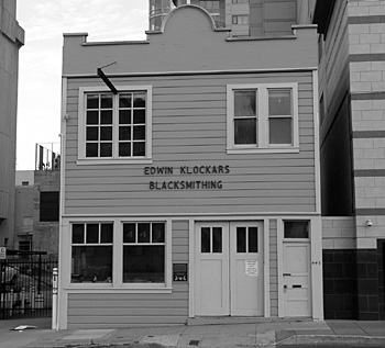
Site 2 — Klockar's Blacksmith Shop: 443-7 Folsom Street. This landmark building houses one of two known extant blacksmith operations in San Francisco — a far cry from the days when forges blazed and anvils rang from scores of smiths throughout the city. Once essential as mechanics in everyday operations of the city, many of the smiths also ranked among the finest craftsmen and artists. The two-story Blacksmith shop is a wood frame structure concluded by a parapet roof, whose profile is characteristic of the Mission Revival style. A very fine example of western vernacular architecture, the building’s “western style” frame facade would have been at home in any of hundreds of late 19th Century towns and villages in the American West. The rest of the lot also contains two auxiliary structures. Because of its uniqueness, the existing use should be retained. |
|
|
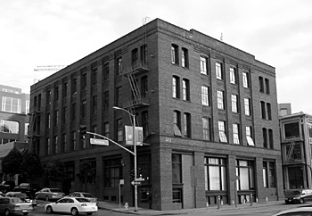
Site 3 — Hills Brothers Coffee Company: 2-30 Harrison Street. Hills Brothers is the largest and most impressive of all coffee buildings along the waterfront. It was built in 1924 having been designed by George Kelham, whose other work includes the Standard Oil and Shell Buildings, the Hills Brothers packing and roasting building is a red brick block with a 175-foot tall square tower. Romanesque arches on the ground and fifth stories and a cornice composed of smaller arches are used to articulate the massive facade. The building is also decorated with pattern brickwork and elaborately crafted bronze grillwork doors. The great tower, generally without fenestration, contains a series of round arches on its upper section and is capped by a pyramidal red tile roof. It was designated a local landmark in 1982. It should remain essentially intact. In 1990, the 1950s addition to the north was replaced with a residential tower, ground-floor retail space and a central plaza in a style compatible with the landmark building. |
|
|
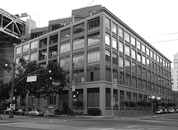
Site 4 — Joseph Magnin Warehouse: 29-35 Harrison Street. This five-story reinforced concrete warehouse was designed by George Applegarth in 1918 for the A.B. Spreckels Securities Co. The five-story block is faced in white concrete, relieved by a rusticated stucco base. The three-part composition is divided by giant pilasters into a series of great horizontal windows whose six-lite pivotal windows are divided by industrial sash. Decorative elements include ashlar scoring of the exterior walls, and brick spandrel panels below each window bay. A restrained classical cornice concludes the powerful industrial design. Due to its massive floor plates, a penthouse addition set back from the site lines on the street could be permitted. |
|
|
Site 5 — Hathaway Warehouse: 400 Spear Street. One of the oldest extant warehouses in the city, the ground story of this splendid brick structure has its origins in the third quarter of the 19th Century, possibly as early as 1856. Additions to the Harrison Street facade were completed in 1875 and the upper sections of the building were completed by about 1900. The two-story brick building, now painted a cream color, is distinguished by projecting brick hood moldings on the ground floor along Spear Street. Brick pilasters with corbelled capitals divide the facade into a series of paired window bays. A projecting belt course separates the two stories on the building’s facades. As late as 1919, its length was virtually double that of today. Around the turn of the century, another portion of it may have been demolished. Because of its small size it would be difficult to alter or add to the building without significantly harming its integrity and therefore it should be retained intact. |
|
|
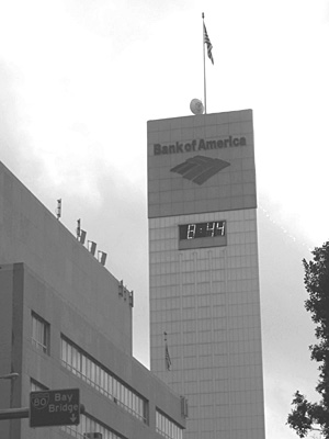
Site 6 — Union Oil Co. Building: 425 First Street. The Union Oil Company Oil Building (1954) is a two-part Art Moderne office block with adjoining tower. The vertical tower — in the shape of a pylon — provides an excellent counterpoint to the office block, characterized by horizontal window bands on a glazed white tile facade. Blue belt courses and glass block windows accentuate the streamlined office design. Its architect, Lewis Hobart, took advantage of an elevated site to design a 138-foot triangular tower, whose white cladding was relieved by a vertical blue strip and orange triangle bearing the name of the company. In 1995, the Union Oil Company logo was replaced with a logo for the Bank of America, and the blue strip was removed. The tower is not only an advertisement, but also the most prominent point of reference for Rincon Hill. A great digital clock also displays the time to travelers enroute to the Bay Bridge or nearby freeways. Since portions of the site are used for parking and vehicular movement, the site could accommodate additional development consistent with the scale and character of the existing building. The Union 76 Clock Tower has been identified as a historic resource in several existing surveys, including this Plan. A new residential development is currently proposed at this location that would remove this resource if built. Given this plan’s policies to encourage housing in Rincon Hill, and the housing potential at this location, residential development on the site may be appropriate if findings of overriding considerations are made. |
|
|
Site 7 — Coffin-Reddington Building: 301 Folsom Street. In the design of this 1937 office/warehouse building for a local firm dealing in wholesale drugs, chemicals, drug sundries and liquors, Frederick H. Meyer, founder of the California College of Arts and Crafts, employed a restrained Moderne idiom. The Coffin-Reddington Building is a two-part reinforced concrete block whose stucco facade has been painted a beige color. The building’s great mass is articulated by differentiating its end bays through the modulation of their width in respect to the central bays. Moderne elements include decorative chevrons and half circles at the frieze and fluted piers, dividing the facade into a series of horizontal window bays with industrial sash. A dentilated lintel, fluted piers, and decorative floral patterns and chevrons decorate the two entrances. The building could accommodate a penthouse set back from the site lines along the street and otherwise should remain essentially intact. |

|
|
Site 8 — Gimbel Brothers Candy Factory: 501 Folsom Street. The Gimbel Brothers Building was constructed in 1916 according to the designs of Alfred Kuhn. The building was used for the production and storage of candy. The four-story block is divided into two sections by an elaborate stringcourse and faced in a red English Garden Wall brick bond. The ground story contains large square windows, some of whose sash has been replaced over the years. Brick pilasters, with stepped capitals, divide the facade into a series of recessed single window bays while differentiated end bays contain paired windows flush with the facade. All windows are concluded by segmental arches whose voussoirs blend well with the orthogonal surface. The building is concluded by a coping above its restrained cornice. The building could accommodate a penthouse set back from the site lines along the street but otherwise should remain essentially intact. |
|
7. Implementation
A key goal of this plan is to create a full-service urban neighborhood to support the substantial new housing development anticipated in Rincon Hill. If the plan is realized, new residents will create significant new needs, which the area’s dated infrastructure cannot meet. While new development will generate real estate transfer taxes and annual property tax increases and pay citywide school fees and meet inclusionary housing requirements, additional investments in parks, streets, and community facilities and services—beyond what can be provided through property tax revenue—is essential to meeting the needs of new residents and fulfilling the City’s goal of creating a residential neighborhood on Rincon Hill supported by the necessary investments in parks, streets and other facilities. To this end, this plan proposes the following implementation strategies:
OBJECTIVE 7.1
Ensure that private development provides funding for public improvements, and their on-going maintenance and operations, in proportion to the need for those improvements that it generates.
OBJECTIVE 7.2
Minimize the amount of direct public funding that must be used to fund and maintain public improvements.
OBJECTIVE 7.3
Use local South of Market residents and First Source employees and provide adequate job training, especially for South of Market residents, for new construction and post-construction jobs created from new development to the maximum extent feasible.
POLICIES
POLICY 7.1
Require new development to implement portions of the streetscape plan adjacent to their development, and additional relevant in-kind contributions, as a condition of approval.
POLICY 7.2
Create a community facilities district to fund capital improvements, operation and maintenance of new public spaces, including the Living Streets, the Harrison/Fremont park, and community spaces in the Sailor’s Union of the Pacific building.
POLICY 7.3
Require new development fee to pay an additional per square foot fee to cover features of the public realm plan, based on the need for the public improvements created by new development, that cannot be paid for through the community facilities district.
POLICY 7.4
The Rincon Hill Streetscape Master Plan serves as the guiding framework for the desing of streets within the Rincon Hill Plan Area. The City shall seek to implement the plan to the maximum extent feasible, both through its oversight and permitting of privately sponsored street improvements as well as City-sponsored improvements.
POLICY 7.5
Ensure that new residential development projects in Rincon Hill comply with First Source Hiring requirements for construction and post-construction employment pursuant to San Francisco Administrative Code Chapter 83.
POLICY 7.6
Encourage new development to make good faith efforts to hire San Francisco residents comprising at least 50 percent of the total construction workforce measured in labor work hours.
8. Pipeline Projects
Notwithstanding any other provisions of the Rincon Hill Area Plan, in recognition of pipeline housing projects at 375 and 399 Fremont Street, all provisions of this Plan shall be considered in connection with the approval of such pipeline projects but are not requirements; provided, however, that the pipeline projects are compatible with the objectives of this Plan taken as a whole.
Amendment by Resolution 13907 adopted 7/6/1995.
Amendments by Resolution 14906 adopted 12/9/2004.
Amendments by Resolution 17009 adopted 5/25/2005.
Amendments by Board of Supervisors Ordinance 0125-05 adopted on 06/21/2005.
Amendment by Board of Supervisions Ordinance 0124-15 Adopted on 07/14/2015.
Amendment by Board of Supervisions Ordinance 0216-15 Adopted on 12/08/2015.