Transportation Element
INTRODUCTION
The Plan for Transportation is composed of several sections, each of which deals with an important component of the local and regional transportation system. The plan sections are (1) General, (2) Regional Transportation, (3) Congestion Management, (4) Vehicle Circulation, (5) Transit (6) Pedestrians, (7) Bicycles, (8) Citywide Parking and (9) Goods Movement. Each consists of objectives and policies regarding a particular segment of the master transportation system and related maps which describe key physical aspects. Since these various travel systems often parallel each other, they must be read together to understand their functions and characteristics. Each must also be understood in relation to the other elements of the Master Plan of the city.
Within each of the nine plan sections are general objectives, which express desirable goals, and policies that prescribe steps toward achieving these goals. They may not always be entirely compatible. For instance, it may not be possible to satisfy all travel needs in the most convenient manner and at the same time maintain a transportation system which preserves and promotes a desirable living and working environment, supports development in the right locations, and is financially feasible for the City to implement. Each specific policy in the separate plan sections might well be seen as a compromise among these overall objectives and policies, based on weighing the advantages, disadvantages and costs of various alternatives.
In establishing the Objectives and Policies, certain Fundamental Assumptions of the nature of transportation are made. In addition, this Element examines and considers the History of Transportation in San Francisco, and establishes the basis from which these policies and objectives sere developed. A separate document, the Implementation Program of the Transportation Element, serves as a set of guidelines that link these Objectives and Policies to the programming of funds for implementing transportation projects.
Fundamental Assumptions
Shaping a Region
The provision of transportation services is a complicated and vital function in urban society. The very shape of the central city and outlying communities is formed by the forces of transportation. Clearly, one of the most difficult challenges for any metropolitan area is to accommodate the transportation needs of its population while maintaining and enhancing the city and region as a desirable place to live and work. On the other hand, some of the most fundamental problems contributing to the deterioration of the quality of life in an urban area -- air pollution, traffic congestion, suburban sprawl, visual blight, depletion of natural resources -- are caused by the inadequate and inefficient provision of transportation services, particularly in relation to the use of adjacent land.
The setting of the San Francisco Bay Area -- the bay, the ocean, the mountains, the three large city centers and the other communities along the bay and the inland valleys -- is a fundamental part of its celebrated quality of life. These same characteristics make the challenge of improving the transportation network particularly complex. The water and hills are obstacles for conventional transportation systems, albeit beautiful ones. The flow of the region's automobile traffic is immune to the political boundaries between San Francisco, Oakland and San Jose, and, increasingly, has neither origin nor destination in these three cities. As open, developable land grows scarce and the central area of the region matures, the impacts of accommodating the movement of people and goods throughout the Bay Area become more significant, particularly in the areas adjacent to transportation infrastructure, and the welfare of a community -- or a neighborhood within a community -- may be pitted against the good of the entire region.
The high costs of investments in any component of a transportation system -- transit, highways, streets, sidewalks, bicycle facilities, freight movement -- underscore the need for comprehensive planning. The interrelationships of different components must be studied, the surrounding land use must support the investment, and the needs of the locality and the entire region must be considered. If the Bay Area's future transportation system is to be successful, it must be managed and developed with creativity, responsiveness to current and future trends, sensitivity to the land use and environment it serves, and cooperation and coordination on both a local and regional scale.
Impacts of Automobile Travel in the City
The accommodation of automobile traffic in San Francisco has long been a controversial issue. The automobile provides access to the City from even the most remote regions of the Bay Area, and is relied upon by many as a means of getting to and around the City. Many efforts in the past have been undertaken to facilitate the movement and accessibility of the automobile, such as the construction of freeways, parking lots and garages, the widening of streets, the narrowing of sidewalks, and the related condemnation of private property. While these undertakings have resulted in its unprecedented convenience and popularity, the operation of an automobile in the city remains constrained by traffic congestion, parking scarcities and a 19th-Century street network that was not laid out for cars and still poses many challenges to through traffic movement.
The efforts to accommodate the automobile have had pronounced repercussions on other aspects of city life. Elevated freeways block views, divide neighborhoods, consume valuable city land and blight adjacent properties. Off-street parking facilities increase building costs, which in turn are transferred to costs of housing and doing business. As a land use, off-street parking facilities compete with and displace land uses that provide greater social and economic benefit to the city. Widened streets, numerous curb cuts and narrowed sidewalks come at the expense of the safety and comfort of the pedestrian. Displacement of housing and small businesses upsets the delicate neighborhood scale and economies that help make the city unique, attractive and livable.
The investments already made in accommodating the automobile seem to trigger the demand for more, but the rise in automobile use and ownership tests the ability of the city's transportation system to further adapt and function. The single-occupant automobile produces more air pollution and uses land and natural resources more inefficiently than any other of San Francisco's transportation modes. These environmental costs become more prohibitive as the volume of automobile traffic increases. With congestion comes slower travel times, less productivity and mounting frustration for drivers -- as well as for transit riders, pedestrians and bicyclists -- not to mention worsened air quality and more wasteful consumption of resources.
A basic assumption of the Transportation Element is that a desirable living environment and a prosperous business environment cannot be maintained if traffic levels continue to increase in any significant way. A balance must be restored to the city's transportation system, and various methods must be used to control and reshape the impact of automobiles on the city. These include improving and promoting public transit, ridesharing, bicycling and walking as alternatives to the single-occupant automobile; limiting the city's parking capacity, especially long-term parking in commercial areas; directing major traffic movements to certain routes; and limiting the vehicular capacity of the city's streets and highways.
Finally, the city must accept a certain level of congestion as inevitable. While it is an undeniable problem, congestion is also an indication that a community has such strong attractions that people are drawn to it in spite of the problem. Congestion is also a means of controlling traffic growth: it ultimately regulates itself. The goal of a balanced transportation system is to minimize congestion while providing attractive alternatives for those who, in consideration of cost, ability, convenience and/or personal preference, choose not to drive automobiles in San Francisco.
Building on a Tradition of Alternatives to the Automobile
A balanced, multi-modal transportation system, including public transit, ridesharing, automobiles, bicycles and pedestrians, is necessary not only for a high quality of life, but also to maintain the economic well-being of the community. Without this balance, the congestion, pollution and scale of development oriented to the automobile instead of human beings would take their toll on the viability and renowned character of San Francisco's commercial and residential districts. They could also result in the penalties that may be assessed by regional governmental agencies such as the Air Quality District when these conditions are not brought into compliance with established standards.
In this respect, San Francisco's traditional reliance on walking, public transportation and other modes for both work and non-work trips has paid off. San Francisco has a considerable and comprehensive variety of transportation alternatives, and commercial and residential districts well-known for their attractiveness and agreeable, walkable character. The amount of land and resources that are devoted to accommodating the automobile is much lower than in other communities in California, allowing for a downtown whose accessibility, compactness and efficiency of land uses and services contribute greatly to its market strength.
In 1992, surveys of automobile and transit use in San Francisco showed the city, unique among all other cities in the Bay Area, was in compliance with the standards set by the Air Quality District for 1999. Therefore, the District determined that San Francisco did not need to develop either a trip reduction ordinance or additional employer programs to reduce automobile commuting, saving the city and its large employers from costs and penalties that would have otherwise applied. The air quality in San Francisco and the nine-county Bay Area has been maintained above all applicable federal standards of pollutants, such that in 1995 the Bay Area became the only large metropolitan area in California to be designated as an Attainment Region by the Environmental Protection Agency. This designation removes the threat of relevant federal sanctions in San Francisco and the Bay Area, removes administrative burdens on its industries, and relieves them from imposition of more extreme emission controls.
The long-standing transportation policies of San Francisco must be reviewed and updated as the city continues to be shaped by technology, economics, demography and natural forces. Nevertheless, these policies have served the city well, and helped position the city and region as a model for other metropolitan areas to emulate. Clearly, the future of the high quality of life and strong market appeal of doing business in San Francisco depends on the success of maintaining and enhancing its balanced, multi-modal transportation system.
History of Transportation in San Francisco
Pre-1906
The development of early San Francisco was strongly influenced by geography. Constrained by the bay, ocean and hills, the city had a limited capacity for expansion. It grew from the northeast waterfront west toward the Presidio and south to Mission Dolores. Public omnibus service was introduced in 1852, followed by horse-drawn cars. The cable car was invented in 1873 to climb the downtown hills, and the first streetcar began operation in 1890. An efficient system of ferries connected San Francisco to Oakland and the continental railway across the bay. Due in part to the city's small size, the geographic constraints, and to the rapid increase in population in the last decades of the nineteenth century, San Francisco became "built out" very quickly in comparison with most other cities on the West Coast.
The Automobile Age: 1906-1960
In the period of downtown reconstruction after the 1906 earthquake, the outer areas of San Francisco developed rapidly. The construction of the Stockton Street, Twin Peaks and Sunset streetcar tunnels between 1914 and 1927 opened areas for development that had been constrained by topography. Regional transportation connections to San Francisco were improved as the Southern Pacific Railroad Bayshore bypass (1908) skirted San Bruno Mountain for quicker access to the Peninsula, and the San Francisco-Oakland Bay Bridge (1936) and the Golden Gate Bridge (1937) linked the city to the East and North Bay. The Bay Bridge accommodated auto traffic as well as the Key System interurban trains that ran on the lower level of the bridge between San Francisco's Transbay Terminal and the East Bay, but the opening of these bridges ultimately encouraged the use of the automobile. The automobile's new popularity led to the demise of the ferry operations and later, the Key trains themselves.
The automobile soon became the dominant means of transportation in San Francisco and the Bay Area. The construction of the Bayshore and other highways, the bridges and tunnels brought a much wider range of communities throughout the Bay Area within commuting distance to San Francisco. The automobile also facilitated the development of outlying portions of the city that were not accessible to, or well-served by, the existing public transit network, such as Twin Peaks and Diamond Heights. However, most of the city's streets had been designed for street and cable car railways, not the automobile. Burdening the street system resulted in parking shortages and growing congestion.
The popularity of the automobile also contributed to the decentralization of the Bay Area. San Francisco's 1948 Trafficways Plan proposed an elaborate network of eight freeways crossing San Francisco and a second bridge parallel to the Bay Bridge to close the gaps in the regional highway system and to respond to growing traffic congestion, which was most severe in the inner cities. Many of the traditional city centers in the Bay Area, such as Oakland and San Jose, experienced severe decentralization as regional shopping centers and new office and industrial parks were developed in suburban communities, and San Francisco's pre-eminence as the region's employment and retail center diminished significantly. As these development trends were spurred by the automobile rather than transit, the automobile soon became the primary means of commuting in the region. This in turn spurred more decentralization and the decline of public transit ridership.
The Freeway Revolt and "Transit First": (1960-1989)
City residents and politicians protested the proposed 1948 Trafficways Plan, fearing that it would destroy the city's livability and character. This response, known as the "Freeway Revolt", led to the deletion of the Western, Park Presidio and Crosstown freeways and, in 1959, the suspension in mid-construction of both the Embarcadero and Central Freeways. The ugliness and intrusiveness of these freeways, and the increased automobile traffic they attracted, encouraged the Board of Supervisors to further reject new alternatives in 1966 for cross-town freeway connections, permitting only the construction of the Southern Freeway (I-280).
Instead of relying on freeways to meet its transportation needs, the city sought to place greater emphasis on mass transportation. In 1973, the San Francisco City Planning Commission and Board of Supervisors adopted the "Transit First Policy", giving top priority to public transit investments as the centerpiece of the city's transportation policy and adopting street capacity and parking policies to discourage increases in automobile traffic. This policy encourages multi-modalism, including the use of transit and other transportation choices, including bicycling and walking, rather than the continued use of the single-occupant vehicle.
Regional and local mass transit diversified and expanded during the 1970's and 1980's. Proposed in 1957, the Bay Area Rapid Transit System (BART) began East Bay and West Bay service in 1972-3, and transbay service in 1974. Commuter ferry service was reinstated between Marin County and San Francisco in 1970. The Golden Gate Bridge Highway and Transit District and SamTrans took over and expanded the Greyhound commuter bus operations in the North Bay (1972) and on the Peninsula (1974), respectively. In 1980, the California Department of Transportation took over the Southern Pacific commuter rail service on the Peninsula (and renamed it CalTrain), and in 1992 the operation of CalTrain was assumed by a Joint Powers Board representing San Francisco, San Mateo and Santa Clara Counties. The San Francisco Municipal Railway (Muni) upgraded its surface streetcar operation to a surface and subway light-rail network in 1979. By the time of the 1989 Loma Prieta Earthquake, public transportation in San Francisco was a diverse, though not seamlessly coordinated, system of regional and local bus service, electric trolley buses, ferries, commuter trains, heavy and light rail transit, and cable cars. After decades of poor coordination and large service gaps between different transit systems, great strides were made in linking and facilitating transfers between local and regional transit services. Muni and BART introduced the "Fast Pass" allowing unlimited trips and free transfers between the two systems for trips made in San Francisco during one month. Plans were drawn for the Muni Metro extension to Mission Bay, connecting CalTrain to Muni Metro and BART, and for the F-line connection between BART/Muni Metro, Upper Market, the Northern Waterfront, the Transbay Terminal and the Ferry Building.
Nevertheless, decentralization of the Bay Area continued, making it difficult for mass transit to meet the needs of residents and commuters traveling to the outlying, suburban parts of the region. Manufacturing continued to diminish in importance as a sector of San Francisco's economy, which was becoming more dominated by such office sectors as finance, administration and service. Much of the growth in the industrial and manufacturing sectors of the Bay Area's economy occurred in the East and South Bay. The Port of Oakland, already at an advantage because of its proximity to multiple railheads and servers, assumed a greater share of the Bay Area's waterfront traffic after it had adapted to cargo containerization, and the Port of San Francisco's Belt Line Railroad became obsolete and was eventually dismantled.
Loma Prieta and Changing Legislation: Post-1990
Due to the damage from the 1989 earthquake, the Embarcadero Freeway, the Terminal Separator Structure, and portions of the Central Freeway were razed. The city has taken official positions not to replace these structures, deferring to both the legacy of the Freeway Revolt and the "Transit First" policy. Twenty years after the policy was adopted, its implementation appears to be a success: nearly all of the substantial growth in commuter travel to and from the Financial District since 1970 has been accommodated on transit. The aftermath of the earthquake, particularly the temporary closure of the Bay Bridge, renewed a reliance on public transportation. New ferry service to the East Bay and expanded BART and CalTrain service continue to attract riders well after the bridge was reopened.
The Transbay Terminal was damaged by the Loma Prieta earthquake but ultimately returned to service. With growing transit use, a joint decision was made to construct a new Transbay Terminal on the existing Transbay Terminal site. It will serve as the terminus for Transbay bus service, for the CalTrain once it is extended from its current terminus at 4th and King Streets, for several Muni lines, and for other regional transit providers. The station would also be located a short distance from ferry service providers, the city's bus and metro routes, BART, and other regional carriers. It would be designed to accommodate pedestrians and bicyclists. If high-speed rail is constructed between northern and southern California, the Transbay Terminal will also serve as San Francisco's terminal.
The benefits of San Francisco's investment in alternatives to the single-occupant vehicle extend beyond its relatively clean air and stabilized traffic congestion. The high transit modal split fostered over the twenty years by official city policy positioned San Francisco, unique among California cities in 1993, in compliance with the requirement of the State Clean Air Act to initiate a Trip Reduction Ordinance, thereby exempting many of the city's employers from burdensome regional regulations.
San Francisco's tradition of promoting alternatives to the automobile serves the city well in light of the passage of the Intermodal Surface Transportation Efficiency Act in 1991. This Act signaled the federal government's new emphasis on funding transportation projects with a multi-modal emphasis. These and other recent, fundamental changes in the objectives and means of planning transportation at all levels of government provide an unprecedented opportunity for the City of San Francisco and the Bay Area. This Transportation Element establishes the following objectives and policies in recognition of this opportunity and the importance of managing transportation in the preservation and enhancement of the Bay Area's high quality of life.
OBJECTIVES & POLICIES
General
OBJECTIVE 1
MEET THE NEEDS OF ALL RESIDENTS AND VISITORS FOR SAFE, CONVENIENT AND INEXPENSIVE TRAVEL WITHIN SAN FRANCISCO AND BETWEEN THE CITY AND OTHER PARTS OF THE REGION WHILE MAINTAINING THE HIGH QUALITY LIVING ENVIRONMENT OF THE BAY AREA.
The city's first responsibility in the planning and operation of its transportation system is to provide the mobility necessary to its residents in pursuing a wide range of opportunities for work, education, recreation and contact with others. The city must also provide for the many persons who come to San Francisco for work and pleasure and who contribute to the life of San Francisco.
Residents and visitors present a formidable array of demands for transportation services and facilities. Since all transportation facilities must by their nature be shared, at least in part, the transportation system can meet individual and special needs only to a limited extent. A balance must be struck between the ultimate goal of providing convenient travel for all people to their desired destinations and the monetary and environmental costs that such a transportation system might incur.
POLICY 1.1
Involve citizens in planning and developing transportation facilities and services, and in further defining objectives and policies as they relate to district plans and specific projects.
Citizen involvement in all planning is essential. At least three different levels of citizen participation can be recognized in transportation planning. First, citywide participation is required for decisions on citywide problems, policies, and facilities. Almost all major improvements have citywide implications and should be subject to citywide, perhaps regional, discussion and debate. Members of community groups as well as advocacy groups representing relevant issues and viewpoints should be included. Second, most citywide facilities have some special impact on a particular part of the city, and therefore affect the residents and businesses in that area. Residents should participate actively in the specific design of these facilities, even though some of the basic decisions have been made on a citywide basis. Third, some improvements and changes have only very localized impacts and, in such cases, the owners and residents of the affected properties should be directly involved in planning decisions.
POLICY 1.2
Ensure the safety and comfort of pedestrians throughout the city.
Safety is a concern in the development and accommodation of any part of the transportation system, but safety for pedestrians (which includes disabled persons in wheelchairs and other ambulatory devices) should be given priority where conflicts exist with other modes of transportation. Even when the bulk of a trip is by transit, automobile or bicycle, at one point or another nearly every person traveling in San Francisco is a pedestrian.
POLICY 1.3
Give priority to public transit and other alternatives to the private automobile as the means of meeting San Francisco's transportation needs, particularly those of commuters.
In order to maintain a desirable living and business environment in San Francisco, the use of mass transit, ridesharing, walking and bicycling must assume a high priority to ensure mobility for commuters and residents alike. Mobility is ideally provided by a well-connected, multimodal system, but where a choice must be made to either provide public transit or accommodate the private automobile, public transit should receive the priority, consistent with the city's Transit First policy.
POLICY 1.4
Increase the capacity of transit during the off-peak hours.
The capacity of the city's transportation system can be used more efficiently by spreading work trip arrival and departure times over a longer period. This could be achieved by such administrative devices as staggering work hours, encouraging shoppers and visitors not to travel during peak hours, altering school hours, and implementing differential bridge tolls. For the streets and highway system, this could mean less congestion, less automobile emissions and a diminished necessity for high capacity freeways. However, the frequency of service and the capacity of the city and regional transit systems must be increased in these off-peak hours if transit is expected to be a primary means of travel in and around San Francisco.
POLICY 1.5
Coordinate regional and local transportation systems and provide for interline transit transfers.
Transportation facilities are interdependent, and efforts should be made to ensure an efficient system by coordination of local and regional efforts. The regional and local transit systems must be closely linked to provide for transfers. Similarly, regional highways and freeways must be integrated with the local street system. Costly mistakes and service redundancies can be avoided by advance planning and agreement among the many agencies involved in transportation planning affecting San Francisco and the Bay Area.
All transit operators should provide free transfers between routes for travel within the city, although fare increments are justified for travel outside the city. A transfer arrangement should be made among BART, AC Transit, the ferries and Muni and other systems to allow for trips outside the region at a reasonable incremental cost. To further enhance coordination, bicycles should be accommodated on all regional public transportation systems.
POLICY 1.6
Ensure choices among modes of travel and accommodate each mode when and where it is most appropriate.
San Francisco and the Bay Area have various means of travel: automobile, bus, streetcar, walking, taxi, cable car, ferry, railroad, BART and bicycling Flying is occasionally used as a means of intra-regional travel. Each mode of travel has special advantages or disadvantages for certain types of trips and for certain origins and destinations. The least costly or most convenient means to satisfy travel demand is not necessarily the best investment in the context of comprehensive planning: cost or convenience must usually be balanced against effects on the environment and impact on land use and development patterns. However, it should be remembered that some modes such as walking and bicycling can be utilized on many streets with minimal environmental and land use impact.
The following conditions listed under each mode choice are not mutually exclusive, and may apply to more than one travel mode, especially when the modes are compatible with each other:
Mass transit should be given priority for the following kinds of trips and/or in the described areas:
-
For work trips generally within and to San Francisco, and to other densely developed parts of the region, especially to all major employment centers.
-
For intercity trips between core areas of major cities and for travel to core areas in general.
-
For trips occurring generally during periods of high travel demands.
-
Where demand for travel between any two or more relatively compact or densely developed areas is high.
-
In areas and around institutions where large numbers of people with limited means or low automobile ownership reside or arrive at a destination.
-
Where travel demand exceeds the capacity of an area to absorb more vehicular traffic without substantial environmental damage or where further capacity for automobile movement or storage is very costly.
-
Where required or useful to stimulate development.
-
For trips to major recreation areas and to sports, cultural and other heavily attended events.
-
For trips to neighborhood commercial districts, especially those that do not contain many automobile-oriented uses.
Automobiles should be accommodated for making the following kinds of trips and/or in the described areas:
-
For trips occurring when and where transit is not well-suited for the purpose, such as shopping for oversized or bulk items (as an alternative, retail delivery services should be encouraged.)
-
For intra-regional trips outside the major cities and for intercity trips between non-core areas of the major cities.
-
Where business travel requires the use of an automobile for short-term and intermittent trips.
-
On streets having the capacity to absorb additional vehicular traffic as an alternative to freeway construction without substantial environmental damage or conflict with land uses.
Walking should be given priority for the following kinds of trips and/or in the specified areas:
-
In parks, on trails and in other recreational areas, and where the enjoyment of slow movement and the preservation of the natural environment would be severely compromised by automobile traffic.
-
For work trips generally within San Francisco, especially the downtown area.
-
Where concentration of activity is high, particularly where streets are narrow and the intervening distances are short, that more convenient access among interrelated activities may be achieved by walking or limited distance people-movers than by other modes.
-
In areas and around institutions where large numbers of people with limited means or low automobile ownership reside or arrive as a destination.
-
Where travel demand exceeds the capacity of an area to absorb more vehicular traffic without substantial environmental damage or where further capacity for automobile movement or storage is very costly.
-
In neighborhood commercial districts, and where cultural and recreational facilities are clustered.
-
Surrounding transit centers and along transit preferential streets, where the facilitation of pedestrian traffic is necessary to successful and safe transit operation.
Bicycling should be given priority for the following kinds of trips and/or in the specified areas:
-
In parks, on trails, on roads of particular scenic beauty, and in other recreational areas, and where the enjoyment of slow movement and the preservation of the natural environment would be severely compromised by automobile traffic.
-
For work trips generally within San Francisco, especially the downtown and other dense areas, especially where automobile parking is scarce.
-
Where concentration of activity is high, particularly where streets are narrow and the intervening distances are short, that more convenient access among interrelated activities may be achieved by bicycling.
-
Where large numbers of people with limited means or low automobile ownership reside or arrive as a destination.
-
In neighborhood commercial districts, and where cultural and recreational facilites are clustered.
-
For trips to sports, cultural and other heavily attended events.
-
As a connector to and from transit, especially regional transit.
-
Along the alignment of the regional Bay Trail network, linking shoreline recreational destinations.
Taxis, water taxis, paratransit services and shuttles should be accommodated for the following kinds of trips and/or in the specified areas:
-
Where there are concentrations of off-peak, nighttime commercial, recreational and cultural activity, particularly where that activity attracts a large proportion of tourists and is within a 5-minute taxi ride from Downtown.
-
Shopping trips where the volume of purchased goods would make the use of public transit inconvenient or difficult.
-
In residential areas, or near facilities and institutions where the facilitation of door-to-door trips is an absolute priority.
-
Adjacent to regional transit connection points.
-
Where the mode, such as a water taxi, affords a trip of special scenic quality.
Freight carriers and delivery vehicles should be accommodated for making the following kinds of trips and/or in the described areas:
-
Where there are concentrations of industrial and manufacturing facilities that depend on the processing, delivery and/or shipment of large quantities of goods and freight.
-
For the bulk movement of refuse and other materials which would become a nuisance and health hazard if stored or accumulated on site.
-
For the loading and unloading of goods and freight at retail and commercial establishments.
-
At the transfer points where bulk equipment, goods and freight exchange modes of travel, such as where land and water freight traffic interface.
-
Along rail or truck routes specifically needed to accommodate the movement, both local and inter-regional, of the activities described above.
-
In areas suited for the storage of bulk equipment, goods and freight.
POLICY 1.7
Assure expanded mobility for the disadvantaged.
Expansion of opportunities for the poor and the underemployed for work, education and recreation depend to a large extent on the adequacy of the transportation system in serving their needs and on the cost of travel to them. The transportation system should be used in part as a tool for improving the situation of less advantaged residents by providing inexpensive and convenient service to areas of growing employment, as well as to educational institutions, medical services and recreation facilities.
POLICY 1.8
Develop a flexible financing system for transportation in which funds may be allocated according to priorities and established policies without unnecessary restriction.
Flexibility in allocating funds is necessary for the maintenance and development of a multi-modal transportation system that is responsive to changing travel demands. Taxes and funds should not be restricted to a specific mode or type of improvement for long periods of time, as long as the re-allocations are consistent with the long-term goal of improving transportation. Financing should be available to all agencies that are concerned with transportation.
POLICY 1.9
Develop a multi-modal emergency transportation plan for the city and encourage the development of complementary plans in the private and public sector, to provide for movement to and from emergency and health facilities from all areas of the city, and to and from the city and other Bay Area communities.
A system accommodating automobiles, surface transit, ferries and other water traffic, emergency aircraft, bicyclists and pedestrians, should be identified to ensure mobility and evacuation in face of a comprehensive variety of natural and man-made catastrophes. The extent of multi-modalism should reflect the possible scarcity of energy and fuel, and the potential disruption to existing infrastructure and rights-of-way.
OBJECTIVE 2
USE THE TRANSPORTATION SYSTEM AS A MEANS FOR GUIDING DEVELOPMENT AND IMPROVING THE ENVIRONMENT.
The use of a transportation system to guide the development and improvement of the city and the region is the necessary counterpart to its function in providing mobility for residents. The transportation system should be used to ensure more than the mobility of the people and goods it serves, it must also ensure the preservation or creation of desired activities and facilities for all sectors of the city's population and economy. The modes of transportation used, as well as the location of routes and design of the system, have a large influence on development patterns and the quality of the overall environment. Conversely, the use of land should support the function of the adjacent transportation facilities. Decisions concerning the location of large retail and employment centers, high-density housing and other projects that generate high volumes of traffic and transit ridership, should consider the impacts on the local and regional transportation system. This relationship between transportation and land use must be recognized in order to facilitate desirable change and to preserve what is good.
POLICY 2.1
Use rapid transit and other transportation improvements in the city and region as the catalyst for desirable development, and coordinate new facilities with public and private development.
The development of an extensive network of rapid rail transit linking the major centers of the region is required if a regional, city-centered plan is to be achieved. Care must be taken to locate transit routes and development so that the transit system itself will encourage more intensive growth in both newly-planned and existing communities. Highways should also be located and designed to avoid encouraging scattered, unplanned patterns of growth that are not accessible by transit. Public and private improvements and developments should be coordinated with transportation projects in advance to ensure that advantage is taken of the opportunities afforded. Development should be regulated, however, so that it will be compatible with the policies of the Master Plan.
POLICY 2.2
Reduce pollution, noise and energy consumption.
Bicycling and walking, the quietest, cleanest and most energy-efficient forms of transportation, should be promoted whenever possible. Gasoline- and diesel-powered automobiles and buses pollute the air, generate substantial noise and consume fossil fuel, in comparison with electric vehicles. The city has long been committed to transit powered by electricity, and this commitment has maintained a high level of environmental quality. Future city programming should work toward noise abatement ordinances and other noise control actions, both by administrative and operational means. For instance, where it is not feasible to use the existing electric transit vehicles, diesel buses should be replaced by quieter and less polluting transit vehicles. Another example is the placement of stop signs in relation to topography to avoid substantial noise caused by acceleration and deceleration.
POLICY 2.3
Design and locate facilities to preserve the historic city fabric and the natural landscape, and to protect views.
Care must be taken to ensure that street and transit improvements are made to enhance the beauty and delicate fabric of the city and to protect views of the city, the bay, the ocean and the hills.
POLICY 2.4
Organize the transportation system to reinforce community identity, improve linkages among interrelated activities and provide focus for community activities.
The manner in which the transportation system is organized may contribute to or undermine social and environmental stability. Through traffic routes should not split neighborhoods or pose insurmountable barriers to movement among them. Street design and location of automobile and bicycle parking should contribute to the establishment of pedestrian-oriented neighborhood centers where residents may congregate. Major transit and bicycle routes and specific transit feeder systems should be located to provide good access to and from neighborhood centers for nearby residents. Freight routes should have convenient access to industrial areas and to regional highway and rail systems, and should be designated to avoid conflicts with other types of traffic -- pedestrian, bicycle, commuter -- in the interest of safety and livability.
POLICY 2.5
Provide incentives for the use of transit, carpools, vanpools, walking and bicycling and reduce the need for new or expanded automobile and automobile parking facilities.
Actions which make transit more convenient, economical and reliable should continue to be a high priority in San Francisco. For those work trips which cannot conveniently be made by transit or bicycle, carpooling provides efficient use of private vehicles and should be encouraged. Bicycling and walking should also be considered as important and appropriate modes of commuting. Transit fare subsidies, cash-out parking programs where parking is subsidized, transit fare discounts in place of parking validations and the provision of secure bicycle parking and shower facilities encourage the use of alternatives to the private automobile.
POLICY 2.6
In conversion and re-use of inactive military bases, provide for a balanced, multi-modal transportation system that is consistent with and complementary to the planned land use and the local and regional transportation system.
The new land uses planned for inactive military bases must be examined to ensure that the transportation demands will be met. These demands must be considered on a local, citywide and regional scale in accordance with the scale of the proposed development and land uses. Any modifications to the existing transportation system serving the area should reflect the objectives and policies of this Element and other elements of the Master Plan.
Regional
OBJECTIVE 3
MAINTAIN AND ENHANCE SAN FRANCISCO'S POSITION AS A REGIONAL DESTINATION WITHOUT INDUCING A GREATER VOLUME OF THROUGH AUTOMOBILE TRAFFIC.
POLICY 3.1
The existing capacity of the bridges, highways and freeways entering the city should not be increased for single-occupant vehicles, and should be reduced where possible. Changes, retrofits or replacements to existing bridges and highways should include dedicated priority for high-occupancy vehicles and transit, and all bridges should feature access for bicyclist and pedestrians.
Much of the existing street infrastructure and parking facilities within San Francisco are at capacity and cannot accommodate significant increases in automobile traffic. Managing the future transportation demand requires a balancing of travel modes, including a greater emphasis on public transit, ride-sharing, and other alternatives to single-occupancy vehicles. Congestion pricing on key freeways and bridges should be implemented to help achieve this end.
POLICY 3.2
New elevated and surface freeways should bypass or terminate outside San Francisco, rather than pass through the city.
The space requirements, the questionable seismic soundness and the physically divisive effects of such freeway structures create significant problems in the city. Connections to any such freeway structures that are built outside the city should be made with at-grade arterials that are better integrated within the existing urban street system.
POLICY 3.3
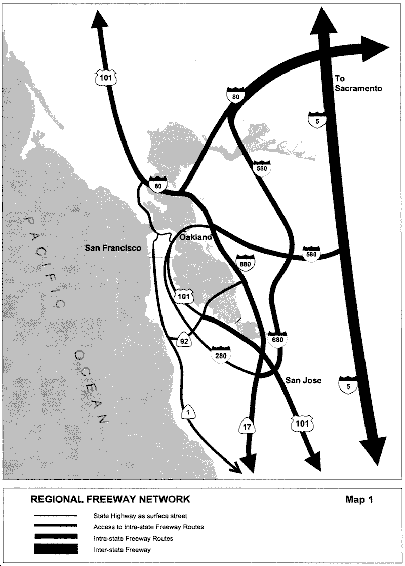
Develop and maintain an efficient system of arterials and thoroughfares to distribute traffic from regional freeways within and through San Francisco's street grid in conjunction with the Bay Region's nine-county Metropolitan Transportation System (MTS).
Unlike many of the Bay Area's newer arterials, many of San Francisco's streets designated for this function were originally designed as residential streets. Measures to calm traffic may be needed on some of these streets where traffic from the freeways travels at speeds that are dangerous and unsuited to the streets' residential function. Landscaping sidewalks and median strips, using sound-insulation materials on adjacent buildings and other buffering measures should be taken along these streets to mitigate the negative impacts of traffic.
POLICY 3.4
Promote I-880, I-80 (East Bay), 101 (North of San Rafael), I-580, I-680 and I-5 as the principal freeways for through automobile traffic and freight truck traffic in the Bay Area and the state.
A few regional freeway segments in the city, such as 101/280 to the Bay Bridge and 101 across the Golden Gate Bridge, are necessary connections to the regional and state freeway system for residents of San Francisco and the northern parts of the Peninsula. However, these segments are often at capacity and cannot accommodate through traffic from a wider region as efficiently as the larger suburban freeway network.
OBJECTIVE 4
MAINTAIN AND ENHANCE SAN FRANCISCO'S POSITION AS THE HUB OF A REGIONAL, CITY-CENTERED TRANSIT SYSTEM.
POLICY 4.1
Rapid transit lines from all outlying corridors should lead to stations and terminals that are adjacent or connected to each other in downtown San Francisco.
No other city in the Bay Area is served with such a comprehensive, region-wide transit system. Transit riders traveling from one end of the region to the other often must make transfers in San Francisco, and would benefit from having transit terminals and stations located close together. Whenever possible, a regional transit corridor should continue through rather than terminate within downtown San Francisco in order to speed through trips and minimize the space needs for turnback and layover facilities in the downtown area.
POLICY 4.2
Increase transit ridership capacity in all congested regional corridors.
Making transit an attractive alternative to the automobile is difficult in suburbs that were developed primarily for automobile access. Increasing the frequency and capacity of regional transit service makes transit more convenient, and is more cost-effective when automobile congestion provides its own incentive for riding public transit.
POLICY 4.3
Where significant transit service is provided, bridges and freeways should have priority transit treatment, such as exclusive transit lanes.
Allowing transit to operate more freely in traffic, especially on freeways and bridges that are subject to traffic congestion, helps make them a more visible and desirable alternative to the automobile.
POLICY 4.4
Integrate future rail transit extensions to, from, and within the city as technology permits so that they are compatible with and immediately accessible to existing BART, CalTrain or Muni rail lines.
Integration includes the physical transit facilities as well as the fare structure. Since a forced transfer from one transit system to another can be a significant deterrent to using transit, the greatest efforts should be made to make the transfer as convenient and uncomplicated as possible.
POLICY 4.5
Provide convenient transit service that connects the regional transit network to major employment centers outside the downtown area.
Many people from outside San Francisco commute to places of work in San Francisco away from downtown. In addition, many San Franciscans commute to places of employment outside downtown or outside the city. While many take transit and rely on connections between local and regional transit, many drive and contribute to peak-hour traffic congestion. Improving the frequency, capacity and operating speed of local transit service from regional transit connections to large employment centers outside downtown will help make transit an attractive alternative to driving. Locating these large employment centers adjacent to high-capacity transit service is equally as important.
POLICY 4.6
Facilitate transfers between different transit modes and services by establishing simplified and coordinated fares and schedules, employing design and technology features to make transferring more convenient, and increasing accommodation of bicycles on transit.
Examples include providing links between transit platforms so that connections can be made directly, with a minimum of walking and entry/exit of fare areas. Monitors that announce arrivals, departures and the progress of transit vehicles and orientation maps should be installed to ease the uncertainty and anxiety of waiting passengers. Expanded peak hour bicycle capacity and reduced peak hour bicycle time restrictions would encourage bicycling to and from transit at one or both ends of the transit trip - an attractive choice to driving alone. This extends the range and convenience of both the transit and the bicycle modes.
Expanded peak-hour bicycle capacity and reduced peak-hour bicycle time restrictions would encourage bicycling to and from transit at one or both ends of the transit trip – an attractive choice to driving alone. This extends the range and convenience of both the transit and the bicycle modes.
POLICY 4. 7
Locate outlying rapid transit stations close to the commercial and high-density residential districts and employment centers of each community.
Many outlying rapid transit stations are located adjacent to freeways and surrounded by large surface parking lots. This pattern of development discourages transit use for those who live in the central cities and come to the suburban areas to work, shop or visit. Locating outlying stations within easy walking distance to the central core of outlying towns makes transit a more viable means of arrival for more people, reinforces the traditional commercial town centers and, by being located in higher-density neighborhoods, also promotes commuting by transit to other communities for suburban residents. Consolidating surface parking into parking garages with other mixed-uses, accommodates automobile drivers who transfer to rapid transit while allowing more efficient and pedestrian-accessible use of land around the station.
POLICY 4.8
Expand and coordinate the use of ferries, water taxis and other forms of water-based transportation with each other and with landside transportation in waterfront communities in San Francisco and across the bay, using San Francisco's Ferry Building as the main transfer point.
Water transit schedules and fares should be coordinated to accommodate riders making both local and regional trips. Water transit service should be coordinated with landside transit operators as well. The creation of a regional ferry consortium would provide a forum for ferry operators to share information, facilities and resources and to coordinate planning.
OBJECTIVE 5
SUPPORT AND ENHANCE THE ROLE OF SAN FRANCISCO AS A MAJOR DESTINATION AND DEPARTURE POINT FOR TRAVELERS MAKING INTERSTATE, NATIONAL AND INTERNATIONAL TRIPS.
POLICY 5.1
Support and accommodate the expansion of San Francisco International Airport, while balancing this expansion with the protection of the quality of life in the communities that surround the Airport.
San Francisco International Airport is one of the world's busiest airports and is of importance to a region extending far beyond the boundaries of the Bay Area. Expansion is necessary for the airport and the Bay Area to maintain its viability and function in the growing Pacific Rim. Recognizing and balancing the airport's regional significance, the livability of adjacent communities and the economic forces driving airport expansion, a reduction of expansion impacts on the communities, such as the improvement of public transportation services, should be encouraged.
POLICY 5.2
Develop direct transit connections from downtown to the Airport that will maximize convenience and minimize confusion for airport patrons.
The Airport is the port of entry for most tourists and businesspeople. Visitors who may be unfamiliar with the region and who have little free time seek convenience, simplicity and directness in making the trip from the airport to Downtown. Walking distances, transfers and waiting time should be kept to a minimum for airport patrons, who are often fatigued from traveling and burdened with luggage.
POLICY 5.3
Encourage the development of a high-speed water transit system from the Airport to the Ferry Building and to Oakland Airport to improve the efficiency and flexibility of the Airport's role in accommodating large numbers of domestic and international air passengers.
Linking the Oakland and San Francisco airports with a rapid shuttle system will enable travelers to use the two airports as virtually a single facility and allow each more opportunity to specialize in distinct travel markets, such as intrastate, domestic and international flights. A link to the Ferry Building would provide travelers with direct access to a broad network of transit options throughout the region.
POLICY 5.4
Encourage the use of public transportation and improve its services between the airport and all Bay Area communities, for airport employees as well as air passengers.
With the expansion of new airport facilities comes job growth and increased air passenger traffic. To minimize additional pollution and congestion in the airport vicinity, extensive programs to decrease the use of the private automobile for airport trips should be implemented in connection with the expansion of the airport facilities.
POLICY 5.5
Develop high-speed rail that links downtown San Francisco to major interstate and national passenger rail corridors as the principle alternative to interstate air travel, and as the primary means to relieve air traffic congestion.
The station should be integrated with the transit network of the city and region. The Transbay Terminal should serve as the downtown San Francisco station. Constructing the station at this location would best serve San Francisco and the region, and take advantage of the infrastructure created by the Caltrain extension downtown to the Transbay Terminal. The Transbay Terminal will be a multi-modal facility and will include facilities for bus, rail, and high speed rail systems, so that long-distance rail passengers can transfer to local and regional transit.
POLICY 5.6
Secure a berth for cruise ships in an attractive location, well-served by public transportation, to enhance San Francisco as a recreational port destination.
OBJECTIVE 6
DEVELOP REGIONAL, MULTI-MODAL FACILITIES FOR THE EFFICIENT MOVEMENT OF FREIGHT AND GOODS
POLICY 6.1
Designate expeditious routes for freight trucks between industrial and commercial areas and the regional and state freeway system to minimize conflicts with automobile traffic and incompatibility with other land uses.
It is very important to coordinate truck route and Bicycle Route network planning. Trucks and bicycles should be routed to separate street where possible. Trucks' greater width and length, obstructed rear sight lines, large turning radius, and the tendency for rear wheels to follow a smaller circle than front wheels all present special concerns to cyclists.
POLICY 6.2
Upgrade and modernize port facilities and landside operations and support transportation systems, responding to new technologies, to enhance the commercial significance of the Port of San Francisco and other Bay Area ports as a unified region competing with other ports on the West Coast.
POLICY 6.3
Encourage the use of water transportation, such as freight ferries and shuttles, to facilitate the region-wide movement of goods and cargo.
Freight ferries, which are used to move freight across water between railheads and other waterfront intermodal freight facilities, help bridge gaps in the region-wide freight movement network. Other forms of water transportation, such as passenger ferries, may also be used to shuttle goods across the bay.
POLICY 6.4
Identify new freight rail corridors and enhance existing ones to improve and shorten links between key freight distribution points in the city and the main interstate railroads and to minimize conflicts with pedestrian, street and passenger rail traffic.
The Dumbarton Bridge provides a shorter, more direct rail link to the East Bay than a route through the South Bay, and should maintain a freight rail function. Accommodating multiple rail servers in the city, particularly to the waterfront, offers more opportunities and better access for the movement of freight.
POLICY 6.5
Develop the facilities and accessory transportation systems serving the Airport to accommodate its growing role as a freight distribution center.
Facilitating intermodal transfers to air travel includes the development of such support services as expanded small package and container handling facilities for landside and ferry services, and the reduction of congestion on freight traffic routes serving the airport.
OBJECTIVE 7
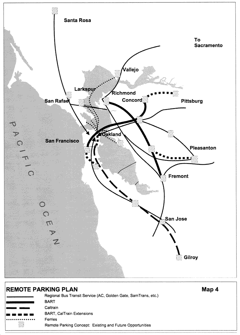
DEVELOP A PARKING STRATEGY THAT ENCOURAGES SHORT-TERM PARKING AT THE PERIPHERY OF DOWNTOWN AND LONG-TERM INTERCEPT PARKING AT THE PERIPHERY OF THE URBANIZED BAY AREA TO MEET THE NEEDS OF LONG-DISTANCE COMMUTERS TRAVELING BY AUTOMOBILE TO SAN FRANCISCO OR NEARBY DESTINATIONS.
POLICY 7.1
Reserve a majority of the off-street parking spaces at the periphery of downtown for short term parking.
POLICY 7.2
Outlying transit terminals and adjacent commuter parking facilities of the regional transit systems leading to San Francisco should be well-marked and easily accessible from regional highways.
POLICY 7.3
Maintain a supply of parking commensurate with demand at outlying intercept parking facilities that have good connections to transit and ride-sharing opportunities.
OBJECTIVE 8
MAINTAIN AND ENHANCE REGIONAL PEDESTRIAN, HIKING AND BIKING ACCESS TO THE COAST, THE BAY AND RIDGE TRAILS.
In addition to pedestrian continuity along all of these trails, continuous bicycle access should be facilitated along the Bay and Coast Trails, which are important regional recreational and touristic facilities.
POLICY 8.1
Ensure that the Coast Trail, the Bay Trail and the Ridge Trail remain uninterrupted and unobstructed where they pass through San Francisco.
Amend the area for Mission Bay to reflect the street grid and bicycle path network of the Mission Bay North and Mission Bay South Redevelopment Plans and Design for Development documents. Add the boundary of the Mission Bay area with a line to text that states "See Mission Bay North and Mission Bay South Redevelopment Plans".
POLICY 8.2
Clearly identify the Citywide Pedestrian and Bicycle Networks where they intersect with the Coast, Bay and Ridge Trails.
OBJECTIVE 9
IMPROVE BICYCLE ACCESS TO SAN FRANCISCO FROM ALL OUTLYING CORRIDORS.
POLICY 9.1
Accommodate bicycles on regional transit facilities and important regional transportation links, such as the City's light rail vehicles, wherever and whenever practically feasible.
Many commuters to San Francisco work outside of downtown and drive alone, contributing to peak hour congestion. If regional transit expanded peak-hour bicycle capacity and reduced peak hour bicycle time restrictions, these commuters could bicycle to and from transit at one or both end of their transit trip - an attractive alternative to driving alone. This would also reduce parking demand at BART and Caltrain stations, ferry terminals, and park-and-ride lots.
POLICY 9.2
Where bicycles are prohibited on roadway segments, provide parallel routes accessible to bicycles or shuttle services that transport bicycles.
Congestion Management
With the increase in complex commuting patterns created by decentralization and reverse commuting in the Bay Area, such problems as traffic congestion and deteriorating air quality have become more severe. State legislation requires that each urban county develop a Congestion Management Program to address these problems. Under the Program, all incorporated jurisdictions within each county are required to develop and implement a Trip Reduction Ordinance, which calls for employers to implement measures designed to reduce the total number of private automobiles. San Francisco recognizes that one effective way to reduce the number of single-occupancy vehicle trips is through a cooperative effort between local jurisdictions and both large and medium-size employers. In addition, the city recognizes that transportation involves the movement of people, rather than vehicles only. Methods of measuring the performance of the city's transportation system should reflect this concept.
The Transit First policy, adopted by the San Francisco Board of Supervisors in 1973, anticipated state and regional strategies to mitigate the problems of traffic congestion. In addition, three other transportation planning strategies are applied to identify and avoid potential transportation deficiencies:
-
Transportation Demand Management (TDM) - a coherent set of policies and programs designed to improve the efficiency of the transportation system by managing the demand for transportation facilities and services;
-
Transportation Systems Management (TSM) - the application of construction, operational and institutional actions to make the most productive and cost-effective use of existing facilities and services; and
-
Parking Management - a set of measures designed to discourage the use of single occupant vehicles; parking availability is closely tied to pricing controls and preferential treatment of rideshare vehicles.
Transportation Performance Measures
In order to address deficiencies in the transportation system, which includes transit systems, streets, sidewalks and parking and loading facilities, decision makers rely on certain measurements of the system's performance. Traditionally, transportation performance was measured by the level of service at street intersections or the number of miles travelled per vehicle -- measures that dealt primarily with motor vehicles. However, these methods of measurement are not well-suited for measuring the performance of alternative modes of transportation to the automobile, such as transit, walking or bicycling. In San Francisco, these alternative modes are not only desirable, they are the primary means of transportation for many types of trips.
OBJECTIVE 10
DEVELOP AND EMPLOY METHODS OF MEASURING THE PERFORMANCE OF THE CITY'S TRANSPORTATION SYSTEM THAT RESPOND TO ITS MULTI-MODAL NATURE.
POLICY 10.1
Assess the performance of the city's transportation system by measuring the movement of people and goods rather than merely the movement of vehicles.
There are a variety of indexes that measure the comprehensive variety of travel modes in San Francisco better than Level Of Service or Vehicle-Miles of Travel, including Modal Split, Person Throughput, Accessibility (proximity of people to activities).
POLICY 10.2
Employ performance measures that address the problems of transportation deficiencies.
Congestion in itself is better perceived as a problem when the specific results are considered, such as hours of delay and the volume of air pollution emissions.
POLICY 10.3
Employ methods that are easily measured, understandable, and useful both for determining the level of deficiency and for comparing alternatives with existing forecasting tools.
As such, the measurements would be of greater value to decision makers, engineers and concerned community members.
POLICY 10.4
Consider the transportation system performance measurements in all decisions for projects that affect the transportation system.
Transit First
The Transit First policy is aimed at restoring balance to a transportation system long dominated by the automobile, and improving overall mobility for all residents and visitors when reliance chiefly on the automobile would result in severe transportation deficiencies. It encourages multi-modalism, the use of transit and other alternatives to the single-occupant vehicle as modes of transportation, and gives priority to the maintenance and expansion of the local transit system and the improvement of regional transit coordination.
OBJECTIVE 11
ESTABLISH PUBLIC TRANSIT AS THE PRIMARY MODE OF TRANSPORTATION IN SAN FRANCISCO AND AS A MEANS THROUGH WHICH TO GUIDE FUTURE DEVELOPMENT AND IMPROVE REGIONAL MOBILITY AND AIR QUALITY.
POLICY 11.1
Maintain and improve the Transit Preferential Streets program to make transit more attractive and viable as a primary means of travel.
The Transit Preferential Streets program includes measures to improve transit vehicle speeds and to minimize the restraints of traffic on transit operations.
POLICY 11.2
Continue to favor investment in transit infrastructure and services over investment in highway development and other facilities that accommodate the automobile.
Every decision to direct expenditures toward improving congestion and parking conditions should first consider the improvement of transit operations.
POLICY 11.3
Encourage development that efficiently coordinates land use with transit service, requiring that developers address transit concerns as well as mitigate traffic problems.
POLICY 11.4
Encourage the development of one or more multi-service transportation outlets at transit-accessible locations for the sale of transit fare instruments and the provision of other kinds of trip information.
Convenience should be the primary factor in locating and operating the multi-service center. Transit patrons should be able to use the center without having to exit or enter faregates, and transit fare instruments should be made available for all modes of transit.
Transportation Demand Management
The purpose of Transportation Demand Management (TDM) is to reduce the number of private automobile trips and to bring about an overall reduction in automobile dependency through education, assistance and incentives. TDM strategies are most successful where they are integrated with land use policies and where the private and public sectors both assist individuals in managing their travel needs. The implementation and administration of these programs should be streamlined to ensure a maximum level of coordination between the public and private sectors.
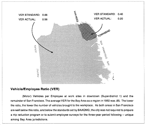
The diagram below illustrates the ratio of vehicles to employees (VER) at workplaces of 100 or more employees. The lower the ratio, the fewer the number of vehicles brought to the workplace. The VER was obtained from a survey of two general areas of San Francisco: greater downtown and the rest of the city. Also shown are the VER standards set by the Bay Area Air Quality Management District (BAAQMD) for San Francisco. In comparison with the standards set for the city, and with the Bay Area as a whole, San Francisco has been successful in keeping its VER low. The TDM policies of this Element are intended to maintain and further San Francisco's accomplishments in promoting commuting alternatives to the private automobile. Also, TDM programs should be expanded from primarily downtown to large employers citywide.
OBJECTIVE 12
DEVELOP AND IMPLEMENT PROGRAMS IN THE PUBLIC AND PRIVATE SECTORS, WHICH WILL SUPPORT CONGESTION MANAGEMENT AND AIR QUALITY OBJECTIVES, MAINTAIN MOBILITY AND ENHANCE BUSINESS VITALITY AT MINIMUM COST.
POLICY 12.1
Develop and implement strategies which provide incentives for individuals to use public transit, ridesharing, bicycling and walking to the best advantage, thereby reducing the number of single occupant auto trips.
Such strategies may include the provision of secure bicycle parking and shower facilities for bicyclists and walkers, subsidized transit passes, and "cash-out" parking programs for persons who do not drive to facilities where automobile parking is subsidized.
POLICY 12.2
Build on successful efforts implemented at numerous private sector worksites, such as the downtown Transportation Brokerage Program and voluntary programs, and adapt such programs for application in new areas as appropriate.
POLICY 12.3
Implement private and public sector TDM programs which support each other and explore opportunities for private-public responsibility in program implementation.
POLICY 12.4
Encourage private and public sector cooperation in the promotion of alternative work programs designed to reduce congestion and the number of automobile trips.
Telecommuting and work-at-home programs can help achieve the desired traffic reductions. Flex-time policies must include coordination with the provision of transit services to assure that an alternative work schedule does not result in an increase in the number of automobile trips.
POLICY 12.5
Phase program implementation in a manner that is most cost effective, and most reasonable in terms of the availability of alternative travel modes and types of trips to be served.
POLICY 12.6
Maximize the utilization of existing sources of revenue targeted or available for program implementation and monitoring to offset additional funding requirements.
POLICY 12.7
Promote coordination between providers of transportation management services, where possible, to enhance the quality of individual programs.
POLICY 12.8
Encourage the creation of Transportation Management Associations where specific needs are identified and coordination with other similar associations and agencies is pursued.
OBJECTIVE 13
PROMOTE THE DEVELOPMENT OF MARKETING STRATEGIES THAT ENCOURAGE AND FACILITATE THE USE OF TRANSIT AND OTHER ALTERNATIVES TO THE SINGLE-OCCUPANT AUTOMOBILE FOR SHOPPING, RECREATION, CULTURAL AND OTHER NON-WORK TRIPS.
POLICY 13.1
Encourage the use of alternatives to the automobile for all age groups in the advertisement of business, recreational and cultural attractions by identifying their proximity to transit facilities and significant landmarks.
POLICY 13.2
Promote the identification of core fixed guideway and regional transit lines, such as BART, Muni Metro, cable car, CalTrain and ferry lines, on maps and literature designed for tourists and visitors.
POLICY 13.3
Use Transit Centers and Visitor Information Centers for the promotion of transit services and the distribution of transit service information.
Transportation Systems Management
Transportation Systems Management (TSM) alternatives are designed to address current transportation system needs through more efficient use of existing transportation facilities. TSM strategies manage the demand and optimize the supply of existing resources to achieve transportation-related goals, and attempt to improve efficiency through the provision of more frequent transit service or the enhancement of transit operating conditions.
OBJECTIVE 14
DEVELOP AND IMPLEMENT A PLAN FOR OPERATIONAL CHANGES AND LAND USE POLICIES THAT WILL MAINTAIN MOBILITY AND SAFETY DESPITE A RISE IN TRAVEL DEMAND THAT COULD OTHERWISE RESULT IN SYSTEM CAPACITY DEFICIENCIES.
POLICY 14.1
Reduce road congestion on arterials through the implementation of traffic control strategies, such as traffic signal synchronization (consistent with posted speed limits) and turn controls, that improve vehicular flow without impeding movement for pedestrians and bicyclists.
The roadway space needed by bicyclists varies between four and six feet depending on the presence of parked cars. The needs of bicyclists must be considered wherever lane widths, especially curb lanes, are proposed to be changed. Multiple turn lanes, designed to reduce congestion for autos, are confusing and dangerous to cyclists and pedestrians, and should not be used if feasible.
POLICY 14.2
Ensure that traffic signals are timed and phased to emphasize transit, pedestrian, and bicycle traffic as part of a balanced multi-modal transportation system.
POLICY 14.3
Improve transit operation by implementing strategies that facilitate and prioritize transit vehicle movement and loading.
POLICY 14.4
Reduce congestion by encouraging alternatives to the single occupant auto through the reservation of right-of-way and enhancement of other facilities dedicated to multiple modes of transportation.
Creating necessary and appropriate facilities for transit, bicycles, carpools, pedestrians, and other modes often requires eliminating general traffic lanes and reducing capacity for single occupant autos. This trade-off is often necessary to create attractive and efficient facilities to ensure safety, reduce congestion, improve neighborhood livability, and accommodate growth consistent with the Transit First policy.
POLICY 14.5
Encourage the use of alternative fuels for City vehicles, transit vehicles and as feasible, any other motor vehicles as a means of reducing toxic automobile emissions and conserving energy.
POLICY 14.6
Reduce peak period congestion through the promotion of flexible work schedules at worksites throughout the City.
POLICY 14.7
Encourage the use of transit and other alternatives modes of travel to the private automobile through the positioning of building entrances and the convenient location of support facilities that prioritizes access from these modes.
POLICY 14.8
Implement land use controls that will support a sustainable mode split, and encourage development that limits the intensification of automobile use.
Land use controls that will lead to a sustainable mode split, and reduced congestion could include:
-
Establishing parking caps for residential and commercial uses
-
Encouraging increased bicycle use by providing bicycle parking and related facilities, including showers and lockers at employment centers
-
Requiring secure bicycle parking in new multifamily housing developments
OBJECTIVE 15
ENCOURAGE ALTERNATIVES TO THE AUTOMOBILE AND REDUCED TRAFFIC LEVELS ON RESIDENTIAL STREETS THAT SUFFER FROM EXCESSIVE TRAFFIC THROUGH THE MANAGEMENT OF TRANSPORTATION SYSTEMS AND FACILITIES.
POLICY 15.1
Discourage excessive automobile traffic on residential streets by incorporating traffic-calming treatments.
Such treatments may include signalization and signage changes that favor other modes of transportation, widened sidewalks, landscape strips, bicycle lanes or transit stops, bicycle-and-transit friendly speed bumps, or reduced traffic speeds.
POLICY 15.2
Consider partial closure of certain residential streets to automobile traffic where the nature and level of automobile traffic impairs livability and safety, provided that there is an abundance of alternative routes such that the closure will not create undue congestion on parallel streets.
Parking Management
Parking management is one of the most effective employer-based strategies for reducing vehicle trips and increasing employee use of alternative modes. In San Francisco, employers have mitigated congestion and air quality and benefited financially by implementing mandatory and voluntary parking management programs. With these congestion management policies, the downtown parking supply is adequate to satisfy demand for long-term and short-term needs. Given the sheer density of development, any increase in parking supply within the downtown will lead to further traffic congestion and the negative impacts associated with it.
OBJECTIVE 16
DEVELOP AND IMPLEMENT PROGRAMS THAT WILL EFFICIENTLY MANAGE THE SUPPLY OF PARKING AT EMPLOYMENT CENTERS THROUGHOUT THE CITY SO AS TO DISCOURAGE SINGLE-OCCUPANT RIDERSHIP AND ENCOURAGE RIDESHARING, TRANSIT AND OTHER ALTERNATIVES TO THE SINGLE-OCCUPANT AUTOMOBILE.
POLICY 16.1
Reduce parking demand through the provision of comprehensive information that encourages the use of alternative modes of transportation.
POLICY 16.2
Reduce parking demand where parking is subsidized by employers with "cash-out" programs in which the equivalency of the cost of subsidized parking is offered to those employees who do not use the parking facilities.
POLICY 16.3
Reduce parking demand through the provision of incentives for the use of carpools and vanpools at new and existing parking facilities throughout the City.
POLICY 16.4
Manage parking demand through appropriate pricing policies including the use of premium rates near employment centers well-served by transit, walking and bicycling, and progressive rate structures to encourage turnover and the efficient use of parking.
POLICY 16.5
Reduce parking demand through limiting the absolute amount of spaces and prioritizing the spaces for short-term and ride-share uses.
POLICY 16.6
Encourage alternatives to the private automobile by locating public transit access and ride-share vehicle and bicycle parking at more close-in and convenient locations on-site, and by locating parking facilities for single-occupant vehicles more remotely.
OBJECTIVE 17
DEVELOP AND IMPLEMENT PARKING MANAGEMENT PROGRAMS IN THE DOWNTOWN THAT WILL PROVIDE ALTERNATIVES ENCOURAGING THE EFFICIENT USE OF THE AREA'S LIMITED PARKING SUPPLY AND ABUNDANT TRANSIT SERVICES.
POLICY 17.1
Discourage the provision of new long-term parking downtown and near major employment centers.
POLICY 17.2
Encourage collaboration and cooperation between property owners, neighboring uses and developers to allow for the most efficient use of existing and new parking facilities.
There is an abundance of off-street parking facilities in the downtown area that are only heavily used during conventional working hours. Activities for which off-street parking is desired that occur after or before this period should be accommodated through agreements that allow a more efficient use of existing facilities.
Vehicle Circulation
OBJECTIVE 18
ACHIEVE STREET SAFETY FOR ALL
Vision Zero is a strategy to eliminate all traffic fatalities and severe injuries, while increasing safe, healthy, equitable mobility for all. The City and County of San Francisco adopted the Vision Zero policy in 2014, prioritizing safety for all road users through good road design; providing meaningful education to the public and decision makers on traffic safety; equitable enforcement of traffic laws focused on dangerous behaviors and locations; and advancing policies that enhance safety.
POLICY 18.1
Prioritize safety in decision making regarding transportation choices, and ensure safe mobility options for all in line with the City's commitment to eliminate traffic fatalities and severe injuries.
POLICY 18.2
Advance policies at the local, state and federal level, as appropriate, to support safety in our transportation system, with a priority on those areas expected to have the greatest impact on improved safety, such as managing travel speeds; reducing reckless, distracted, and impaired driving; ensuring pedestrian right of way; and reducing barriers to building safe streets.
POLICY 18.3
Focus the City's limited resources toward those areas most in need of safety improvements, based on appropriate data, recognizing that those most disproportionately impacted by traffic injuries and deaths are children, seniors, people of color and those in low-income communities.
OBJECTIVE 19
ESTABLISH A STREET HIERARCHY SYSTEM IN WHICH THE FUNCTION AND DESIGN OF EACH STREET ARE CONSISTENT WITH THE CHARACTER AND USE OF ADJACENT LAND.
There should be a hierarchical system of streets functioning in accordance with the planned movement of vehicles and the management of congestion. Street design, capacity and treatment should be a direct manifestation of the streets intended use in satisfying both present and prospective travel demand, and also its non-traffic purposes such as open space and pedestrian movement. It is recognized that in some cases it will be necessary to determine a maximum level of traffic for which street capacity will be provided, implying a tolerable level of congestion as a constraint, if other objectives of the city are to be attained.
Safety and livability along the city streets are primary concerns. This element seeks to balance the needs for vehicle circulation in the provision for through traffic on major arterials and discouragement of it on local streets, particularly residential streets. The following factors determine the selection of major and secondary arterials:
-
The width of the right-of-way relative to traffic capacity required;
-
The extent of transit use on the street;
-
Land uses bordering the street;
-
Safety of the street for moderate- and high-speed traffic, and the ability to "calm" traffic where appropriate;
-
The relation of the street to the definition of the neighborhood by its residents;
-
The presence or absence of conflicts caused by driveways, parking, and deliveries to commercial uses.
Certain streets, such as Geary Boulevard, Van Ness Avenue, Columbus Avenue and The Embarcadero, are important to more than one mode of transportation, and a balance of transportation systems must be maintained. Even with ample right-of-way width, the ability of these streets to be all things to all users is inherently compromised. Special attention, including the allocation of resources, the range of treatments and the long-term improvement strategies, should be given to achieve the desired balance on these streets.
Table 1: Classification of Elements in Vehicle Circulation Plan
-
Freeways: Limited access, very high capacity facilities; primary function is to carry intercity traffic; they may, as a result of route location, also serve the secondary function of providing for travel between distant sections in the city.
-
Major Arterials: Cross-town thoroughfares whose primary function is to link districts within the city and to distribute traffic from and to the freeways; these are routes generally of citywide significance; of varying capacity depending on the travel demand for the specific direction and adjacent land uses.
-
Transit Conflict Streets: Streets with a primary transit function which are not classified as major arterials but experience significant conflicts with automobile traffic.
-
Secondary Arterials: Primarily intra-district routes of varying capacity serving as collectors for the major thoroughfares; in some cases supplemental to the major arterial system.
-
Recreational Street: A special category of street whose major function is to provide for slow pleasure drives and cyclist and pedestrian use; more highly valued for recreational use than for traffic movement. The order of priority for these streets should be to accommodate: 1) pedestrians, hiking trails or wilderness routes, as appropriate; 2) cyclists; 3) equestrians; 4) automobile scenic driving. This should be slow and consistent with the topography and nature of the area. There should be adequate parking outside of natural areas.
-
Collector Streets: Relatively low-capacity streets serving local distribution functions primarily in large, low-density areas, connecting to major and secondary arterials. To be identified in area plans.
-
Local Streets: All other streets intended for access to abutting residential and other land uses, rather than for through traffic; generally of lowest capacity.
-
Living Streets: “Living streets” can include streets, alleys and other public rights-of-way. They serve as both an open space resource for residents and visitors as well as a thoroughfare for local traffic. Physical improvements to living streets should include traffic calming measures and consistent tree plantings to create a residential oriented open space amenity that co-exists with limited vehicular traffic. Living streets primarily serve pedestrians and bicyclists, but should also accommodate local automobile traffic and parking. On living streets, pedestrians take precedent over automobile traffic; programming may include pedestrian enclaves (see discussion following POLICY 25.3).
-
Congestion Management (CMP) Network: The network of freeways, state highways and major arterials established in accordance with state Congestion F Management legislation. Transit Conflict Streets are included in this network as well.
-
Metropolitan Transportation System (MTS) Streets, Highways and Freight Network: A regional network for San Francisco of freeways, major and secondary arterials, transit conflict and recreational streets meeting nine criteria developed by the Metropolitan Transportation Commission as part of the Regional Transportation Plan. The criteria identify facilities that provide relief to congested corridors, improve connectivity, accommodate travel demand and serve a regional transportation function. Due to the specific nature of the criteria, the MTS street and highway network is generally consistent with, but not identical to, the CMP network.
-
Relationship Between Function and Physical Design: No rigid design standards can be established on the basis of the functional categories established above, although higher capacities will generally be associated with freeways and major arterials. Capacities must be determined on the basis of the level of traffic demand, the space available for traffic and the nature of the surrounding environment.
*Pedestrian and bicyclist use will occur and need to be provided for on all street classifications except freeways.
Table 2: Design Guidelines for Streets
Design of streetscape and pedestrian elements should follow the policies and guidelines for the appropriate street type as described in the Better Streets Plan, as adopted by the Board of Supervisors. The Better Streets Plan is incorporated herein by reference. The street types in the Better Streets Plan are intended to guide the design of streetscape and pedestrian features, and not to replace functional transportation classifications.
Major and Secondary Arterials
-
Where residential uses abut on major and secondary arterials, they should be screened visually and physically wherever possible.
-
A consistent pattern of trees at regular intervals should be used to identify major streets.
-
Medians should be landscaped with attention given not to diminish the safety and sightlines of traffic, especially at intersections.
-
Extensive buffers should be used to separate busy arterials from active pedestrian areas.
-
Sufficient space should be provided in the right-of-way to allow safe bicycle movement on all city streets.
-
The brightness (apparent illumination) of street lighting should be greater than on residential streets.
-
Destination information should be concentrated on major streets with signs used to route traffic on the major streets system.
Local Residential Streets
-
Excessive traffic speeds and volumes should be restricted and discouraged by every means possible per Policy 18.4.
-
Where possible, vehicular access directly to and from local streets should be from other than major arterials, e.g., via a secondary arterial or collector street.
-
When alternate access is possible, residences should not access to major arterials.
-
Local streets, other than collectors, should be primarily for access to residences and to serve for emergency vehicles; pedestrian-dominant streets with the maximum feasible amount of street space devoted to environmental amenities desired and needed by the residents.
-
Residential streets should be well-lighted without being excessively bright.
-
Sufficient space should be provided in the right-of-way to allow safe bicycle movement on all city streets.
Intersections
-
All intersections should accommodate safe pedestrian crossings. Accommodations may include bulb-outs to shorten the distance that pedestrians must cross; pedestrian refugees in the middle of major arterials such as Market Street, for pedestrians to rest safely if they do not cross within one light cycle; pedestrian signals; pedestrian-priority signal timing; and other pedestrian facilities. Every street intersection should accommodate pedestrian crossings safely; intersections that sacrifice pedestrians crossing opportunities to better accommodate automobile traffic should be re-designed.
-
Street width, traffic controls, destination and route information and illumination should be designed to maximize safety.
-
Two intersecting residential streets should have minimal roadway width, wide sidewalks and no change in illumination from that on the streets themselves.
-
Intersections of residential streets and major arterials that are not transit corridors should be minimized; where they must intersect, cross and left-turn movements should be limited by curb alignments or medians.
Table 3: Guide to the Vehicle Circulation Plan
Bernal Heights Boulevar: This boulevard should function as a recreational street, with emphasis on pedestrian and bicycle use and with minimal auto capacity.
Central Freeway: Alternatives to retrofitting the portion north of Mission Street should address and resolve the urban design, street livability (especially Oak, Fell and Laguna) and environmental problems created by the existing viaduct.
Areas directly beneath the Central Freeway should be activated to minimize the division between neighborhoods, and barriers for pedestrians. Activation of these spaces could be achieved through the development of commercial facilities, recreation spaces or other pedestrian traffic generating uses.
A comprehensive study of benefits and impacts of removal of the Central Freeway south of Market Street should be conducted. This study should include analysis of the impacts and benefits on surrounding neighborhood livability, local and regional transportation, especially Muni and regional transit services, and economic impacts.
Cross-Over Drive: There should be no connection with John F. Kennedy Drive. The Drive should be redesigned to minimize its intrusion in the Park, with a capacity similar to Park-Presidio Boulevard, and should be carefully aligned to avoid tree removal.
Doyle Drive: This road should be improved for greater safety and minimal conflict with the recreational and scenic values of the Presidio; design capacity should be no greater than three lanes in each direction.
The Embarcadero: The roadway between Mission Bay and North Point Streets is being reconstructed as an attractive landscaped roadway having at least two moving lanes in each direction, an exclusive transit right-of-way, bicycle lanes and separated access and loading areas at piers in maritime use.
Frederick Street: If Kezar Drive is reconfigured, this street would no longer be required for truck traffic and should be changed to a local street function.
Geary Boulevard: To the extent possible most east-west travel in the Western Addition and Inner Richmond should be channeled onto this street to divert traffic from nearby residential streets. Employing TSM measures at key intersections and improved left-turn connections are desirable.
Gough Street: This street should not be widened or made unidirectional north of Pine Street.
Transportation improvements on this street should be conscious of increased transit and pedestrian activity where the Hayes Gough Neighborhood Commercial Transit district crosses Gough Street.
Great Highway: The design capacity of this road should be reduced substantially to correspond with its recreational function; emphasis to be on slow pleasure traffic, bicycles and safe pedestrian crossings.
Guerrero Street: Although Guerrero, Valencia and South Van Ness serve as major and secondary arterials at the present, the improvement of transit service should be accompanied by steps to reduce through traffic and make these streets more compatible with residential uses.
Harney Way: Proposed to serve Candlestick Point, Hunter's Point Shipyard, and their proposed mixed-use development. Refer to the Candlestick Point Subarea Plan, the Bayview Hunters Point Area Plan, the Hunters Point Shipyard Area Plan, and the Hunters Point Shipyard Redevelopment Plan. Increase in vehicle capacity is anticipated.
John F. Kennedy Drive: Through, non-park automobile traffic on this recreational drive should be eliminated.
Kezar Drive: This road should be reconfigured to restore the corner of the park to full recreational use; design capacity no greater than that of the Fell and Oak couple.
Market Street: Market Street should be honored and protected as San Francisco’s visual and functional spine. The City should engage in a comprehensive redesign of Market Street from the Embarcadero to Castro Street. Improvements to Market Street should emphasize its importance for pedestrians, cyclists, and transit.
Nineteenth Avenue: This heavily trafficked street should be landscaped as a parkway with the same capacity. Simultaneous measures should be taken to maintain the low levels of through traffic on parallel streets.
O'Shaughnessy Boulevard: Functionally, this route must provide for crosstown movements; in design, it should remain a scenic-recreational drive, not intended for heavy traffic.
Pine Street-Bush Street: As transit service in the corridor is improved, priority should be given to calming traffic and landscaping along these residential streets west of Van Ness Avenue.
Valencia Street: This street should act as a neighborhood collector street as well as a principal bicycle arterial.
NOTE: This section refers to the Vehicle Circulation Plan map. Except where indicated no increase in the vehicular capacity of any thoroughfare is intended.
POLICY 19.1
Wherever feasible, divert through automobile and commercial traffic from residential neighborhoods onto major and secondary arterials, and limit major arterials to nonresidential streets wherever possible.
Major and secondary arterials are to carry traffic among districts in the city. Local streets are intended only to provide access to and from homes and other uses within each neighborhood. However, many residential streets function as major or secondary arterials, and because there are no other alternatives, the function of these streets is needed to prevent traffic from spreading onto other residential streets. In such cases, buffering measures such as landscaping in sidewalks and medians should be taken to mitigate the impacts of traffic.
POLICY 19.2
Design streets for a level of traffic that serves, but will not cause a detrimental impact on adjacent land uses, nor eliminate the efficient and safe movement of transit vehicles and bicycles.
The need for traffic carriers must be balanced against the adverse effects of heavy traffic on the use of adjacent land and the quality of the environment. The needs of residents for peace and quiet, safety from harm, and useful open space must be given consideration. Each area and each street of the city have different characteristics which determine the level of traffic which can be absorbed without serious adverse impacts. The following factors should be the basis for a judgment on the acceptable levels of traffic on a specific street:
- The predominance of land uses fronting the street;
- The distance between the curb and building line established by sidewalk width or setback;
- The presence or absence of buffering between street and building in the form of landscaping, change in elevation, or similar condition;
- The level of pedestrian and bicycle traffic;
- The proportion of the street which is residential in land use;
- Whether residences face the street;
- The presence of hospitals, schools, parks, or similar facilities on or near the street.
The widening of streets at the expense of sidewalks or of setbacks should not occur where space is necessary for pedestrian movement, buffering from noise, useful open space and landscaping. This is especially true in densely populated neighborhoods with little public or private open space. No additional sidewalk narrowings, tow-away zones and one-way streets should be instituted in a residential neighborhood if it would compromise the safety and comfort of the pedestrian resident. Existing tow-away lanes should be phased out if they present a hazard to pedestrian safety. In addition, widening of streets should not occur at the expense of bicycle travel. The roadway space needed by bicyclists, whether between the line of traffic and the curb or the line of on-street parking varies. The needs of bicyclists must be considered wherever the curb lane is proposed to be narrowed. Street restripings and widenings may be appropriate in industrial areas where access for oversize freight vehicles is important, but these projects should not reduce or eliminate the efficient movement of transit vehicles and bicycles.
POLICY 19.3
The existing single-occupant vehicular capacity of the bridges, highways and freeways entering the city should not be increased and should be reduced if needed to increase the capacity for high-occupancy vehicles, transit and other alternative means of commuting, and for the safe and efficient movement of freight trucks. Changes, retrofits, or replacements to existing bridges and highways should include dedicated priority for high-occupancy vehicles and transit, and all bridges, where feasible, should feature access for bicyclists and pedestrians.
It is recognized that provision for further vehicular access into the city would conflict with the environmental objectives of the city, overload the city street system, and jeopardize the city's commitment to mass transit. This policy allows for the introduction of exclusive transit, bike and carpool/vanpool lanes on bridges, highways and freeways where these lanes are compatible with the overall transportation system's needs.
POLICY 19.4
Discourage high-speed through traffic on local streets in residential areas through traffic "calming" measures that are designed not to disrupt transit service or bicycle movement, including:
- Sidewalk bulbs and widenings at intersections and street entrances;
- Lane off-sets (chicanes) and traffic bumps;
- Narrowed traffic lanes with trees, landscaping and seating areas;
- Colored and/or textured sidewalks and crosswalks; and
- Median and intersection islands.
POLICY 19.5
Mitigate and reduce the impacts of automobile traffic in and around parks and along shoreline recreation areas.
Streets in large parks, around small parks and along recreational parts of the shoreline should function primarily for access to recreational facilities and for scenic driving, not as thoroughfares. Heavy or fast surface traffic endangers pedestrians and cyclists, cuts off access to recreation and reduces the pleasure of being in parks by causing noise, pollution and visual disharmony. Excessive automobile traffic also inhibits the movement of freight rail, freight and delivery trucks and vans that supporting the maritime uses along the waterfront. Pedestrian entrances to parks should be at street intersections to the extent possible.
POLICY 19.6
Use the Street Hierarchy System of the Transportation Element as the foundation for any national, state, regional and local network of streets and highways in San Francisco.
The Street Hierarchy System of the Transportation Element incorporates the CMP and MTS networks, which were developed with the cooperation of local, regional and state agencies and representatives. Any future classification of streets and highways should reflect the structure of the hierarchy system of this document.
OBJECTIVE 20
PROVIDE FOR CONVENIENT MOVEMENT AMONG DISTRICTS IN THE CITY DURING OFF-PEAK TRAVEL PERIODS AND SAFE TRAFFIC MOVEMENT AT ALL TIMES.
The intent is to provide a convenient vehicular system of streets and arterials which function well in meeting normal traffic demands, especially those included in the Congestion Management Plan. At the same time it is recognized that congestion can never be eliminated completely, especially during periods of peak demand.
POLICY 20.1
Promote increased traffic safety, with special attention to hazards that could cause personal injury.
Various measures can be taken to reduce collisions, especially those involving serious personal injury. Particular attention needs to be given to improving bicyclists’ safety since conditions that may be inconsequential to automobiles can be disruptive, disabling, or even life threatening to bicyclists, and are the cause of many bicyclist collisions. In some cases redesign of the roadway and of intersections to reduce conflicts between vehicles, bicyclists and pedestrians is required; in others all that is necessary is to improve clarity of signs and of routing so that there is less driver uncertainty and hesitation.
MASS TRANSIT
OBJECTIVE 21
GIVE FIRST PRIORITY TO IMPROVING TRANSIT SERVICE THROUGHOUT THE CITY, PROVIDING A CONVENIENT AND EFFICIENT SYSTEM AS A PREFERABLE ALTERNATIVE TO AUTOMOBILE USE.
In order to encourage residents, commuters, and visitors to switch their travel modes away from the automobile, we must improve transit service to make it a preferred alternative. Improvements to the existing system can be implemented at a relatively low cost, however, such improvements are often resisted due to real or perceived negative impact on parking or traffic circulation. For this reason, transit improvements should be based on a rational street classification system in which all transportation functions of the street network are analyzed, and only certain streets or locations are designated "transit preferential." Transit preferential streets (TPS) should be established along major transit routes, and general traffic should be routed away from these streets wherever possible.
In certain locations pedestrian' needs must also be addressed in transit system improvements. This is important near major activity centers and interline transfer points. For this reason "transit centers" should be established as part of the transit preferential streets (TPS) system where pedestrian safety, accessibility, and circulation needs are addressed, and transit information and minimum passenger amenities are provided.
POLICY 21.1
Give priority to transit vehicles based on a rational classification system of transit preferential streets.
The TPS classification system should consider the multi-modal functions of the street, the existing and potential levels of transit service and ridership, and the existing transit infrastructure. Through street classification, transit preferential treatments should be concentrated on the most important transit streets, and the treatments applied should respond to all transportation needs of the street. For example, on streets that are major arterials for transit and not for automobile traffic, treatments should emphasize transit priority. On streets that are major arterials for both transit and automobiles, treatments should emphasize a balance between the modes, emphasizing the movement of people and goods rather than vehicles. This method ensures that transit preferential treatments are applied in the most efficient and cost effective manner.
Table 4: Transit Preferential Street Classification System
| Function | Criteria | Recommendation |
|---|---|---|
| Primary Transit Street --Transit Oriented |
Not a major arterial, AND,
|
All transit priority treatments may be applied based on established guidelines. The emphasis should be on moving transit vehicles. Impacts on automobile traffic should be of secondary concern. |
| Primary Transit Street --Transit Important |
Major arterial, AND,
|
All treatments should be designed to improve the balance between modes of Transportation. The emphasis should be on moving people and goods, rather than on moving vehicles. |
| Secondary Transit Street |
|
Treatments should be low-cost and geared to solving a specific transit problem. |
| Transit Center | An interline transfer point, AND
|
Treatments should be designed to emphasize pedestrian as well as transit needs. Safety, accessibility, circulation, information, and aesthetics concerns should all be addressed. |
TPS measures and treatments vary in the effectiveness of enhancing transit operation, and should relate to the function of the street-- Transit Oriented, Transit Important, and Secondary Transit -- on which they are applied. The treatments and measures include:
- Transit exclusive/priority lanes;
- Bus stop reduction programs;
- Stop sign placement/reduction programs;
- Traffic signal phase modifications;
- Traffic signal preemptions;
- Sidewalk bus bulbs; and
- Improved traffic law enforcement.
In general, the use of more than one of these treatments along Primary Transit Streets is justified due to the transit-moving function of the street, whereas the Secondary Transit Streets may call for lesser treatments. The appropriateness of treatments along any Transit Preferential Street depends on other issues as well: the land uses adjacent to the street, the importance of the street to other transportation modes, urban design issues, community safety, etc. In every instance, transit preferential street treatments should be applied on a case-by-case basis.
The following terms and standards have been defined by the Planning Department, the Municipal Railway and the Department of Parking and Traffic for establishing the Transit Preferential Street Classification System:
Frequency of Service (peak headway, all transit lines operating on street or corridor segment)
High: < every 2 minutes Medium: >2 minutes, ~ 4 minutes Low: > 4 minutes
Interline Transfer Point Transfers between different transit lines, including different operators
Rail Transit Line -- Any public transportation line (local, commuter-oriented, regional) that operates on rails.
Regional Transit Terminal--The last revenue stop on a transit line that operates within San Francisco and at least one other Bay Area county.
Transit Ridership (average weekday, all lines on a street or corridor segment)
High: > 45,000 Medium: <45,000, and = 25,000 Low: <25,000
Transit Station -- A permanent facility devoted primarily to transit operation and inaccessible for private automobile traffic that includes a loading platform for transit riders adjacent to a designated stopping area for transit vehicles.
POLICY 21.2
Reduce, relocate or prohibit automobile facility features on transit preferential streets, such as driveways and loading docks, to avoid traffic conflicts and automobile congestion.
Limiting curbcuts allows traffic, specifically transit vehicles, to proceed more efficiently. New curb cuts for access to private property should be avoided when possible. In some instances, curb cuts are restricted.
See Map 10 of the Market Octavia Plan Area
POLICY 21.3
Develop transit preferential treatments according to established guidelines.
Treatment guidelines are important in establishing consistency in treatment type and design, and to ensure that all functions of the streets are considered in treatment design, not just transit. The emphasis is on reducing conflicts between modes wherever possible and on moving people and goods rather than on moving vehicles.
POLICY 21.4
Develop transit centers according to established guidelines.
Transit centers have significant potential to improve transit service by improving conditions at major stops and transfer points. Transit centers should address both pedestrian and transit needs and be designed to reinforce the link and interdependence between the surrounding neighborhood and the transit system, enhancing the sense of place for the neighborhood, and improving the visibility of the transit system. Guidelines must be followed to facilitate design consistency and ensure that safety, accessibility, circulation, information, comfort and aesthetic issues are adequately addressed. Transit Center treatments include enlargement of passenger queuing areas by bulbing at bus stops; the accommodation of passenger needs e.g. shelter, transit information; and by ensuring that adequate safety, accessibility, circulation, and aesthetic concerns are addressed.
POLICY 21.5
Place and maintain all sidewalk elements, including passenger shelters, benches, trees, newsracks, kiosks, toilets, and utilities at appropriate transit stops according to established guidelines.
Transit amenities should be provided according to the importance of the transit station. On primary transit streets, greater numbers of amenities for waiting riders should be provided; on secondary transit streets, fewer amenities may be provided. All amenities should be designed and located to provide for comfort for waiting passengers, ease of access to and from the waiting bus, accessibility of the adjacent sidewalk, and to denote the transit station as a special place in the streetscape environment.
POLICY 21.6
Provide priority enforcement of parking and traffic regulations on all Transit Streets, particularly Transit Preferential Streets.
Transit service is substantially improved when enforcement of existing parking and traffic regulations is applied. Enforcement efforts should be maximized by establishing a priority system whereby enforcement is first applied on the primary transit streets. This includes enforcement against meter feeding, illegal parking, double parking, bus zone parking, and illegal use of bus lanes.
POLICY 21.7
Encourage ridership and clarify transit routes by means of a city-wide plan for street landscaping, lighting and transit preferential treatments.
Sidewalks along transit routes should be attractive and well-lit to encourage walking to and from transit. Streetscape design elements such as trees and lighting are often placed without regard to the transit lines operating on the street. Many lines use fixed guideways which are as much a part of the streetscape as the trees and lights. Street design which is coordinated with transit routes improves the ability to comprehend the routing of lanes and the layout of the transit system.
POLICY 21.8
Intensify overall transit service in the "central area."
The "central area" refers to the northeast quadrant of the city. More travel occurs to and within this area than any other; traffic and pollution levels are highest, and the streets are more congested. It is important to give the highest priority to an intensification and enhancement of transit service within this area. San Francisco's tradition of diversity in transit modes, including surface, subway, rail and water transit, should be reinforced and expanded to offer a wide range of alternatives to potential riders.
POLICY 21.9
Improve inter-district and intra-district transit service.
During non-peak hours, while travel to downtown for shopping and entertainment is still substantial, there is much more travel between and within districts in the city. In a "grid" network of transit services, the potential to improve inter- and intra-district transit travel relies on improving certain important cross-town lines. Transit service on these lines should be frequent, well-coordinated with other transit services and corridors, and as quick and direct as possible.
POLICY 21.10
Keep fares low enough to obtain consistently high patronage and encourage more off-peak use.
Transportation is a public service not unlike street lighting, sewage service or fire protection. Nearly all transportation is subsidized to some degree with public funds. It is no more reasonable to expect transit to "pay its way" with the fare box than it is to expect streets to pay their way. Overly expensive transit fares, in comparison with the indirect taxes imposed on automobile use, discourage transit use.
POLICY 21.11
Promote the electrification of bus operation.
Electric trolley buses are cleaner, quieter and often faster than diesel buses. In planning for the conversion of bus operation, consideration should be given to topography, bus operation in traffic, air quality, noise and visual impacts of the overhead wires.
POLICY 21.12
Use the Transit Preferential Street network as the foundation for any national, state, regional or local transit street hierarchy system in San Francisco.
A coordinated effort by different transportation and planning agencies and advocates has led to the criteria and standards established to develop the TPS network. This network should be reflected in any future development of transit street hierarchies.
POLICY 21.13
Create dedicated bus lanes and Bus Rapid Transit (BRT) lanes to expedite bus travel times and improve transit reliability.
On some transit oriented and transit important streets dedicated bus lanes and Bus Rapid Transit lanes should be installed to expedite transit travel times and improve transit reliability. Analysis consistent with the City’s Transit First Policy should determine the most appropriate routes for dedicated lanes.
POLICY 21.14
Engage new technologies that will emphasize and improve transit services on transit preferential streets.
Reliability and efficiency of service impact a users’ decision to select transit over alternative modes of transportation. Modern technologies such as transit preferential signaling and transit tracking and notifications such as Next Bus, can increase transit reliability, efficiency and use. The City should install technologies with these objectives on transit preferential streets.
OBJECTIVE 22
DEVELOP TRANSIT AS THE PRIMARY MODE OF TRAVEL TO AND FROM DOWNTOWN AND ALL MAJOR ACTIVITY CENTERS WITHIN THE REGION.
The automobile cannot serve as the primary means of travel to and from downtown. An alternative means of equal convenience and greater efficiency is required, not only to downtown, but also among all major activity centers. While direct service is available from almost all parts of the city to downtown, travel is often slow and vehicles are overcrowded during the peak hours. Crowding can never be eliminated completely. However, it is important for continued patronage that transit service, from feeder buses to regional trunklines, accommodate basic ridership comfort in conformance with the service standard ratio of passengers to seats for each operator and type of transit vehicle. Travel to downtown should be possible in less than 30 minutes from all parts of the city. This can be achieved with express buses, exclusive bus lanes, and construction and expansion of rapid transit lines along major corridors.
The use of transit to travel between the suburbs and downtown and other major centers in the city can only become primary with the development of a good regional transit system connecting downtown to other parts of the region. Existing regional rail lines should be expanded where feasible.
POLICY 22.1
Provide transit service from residential areas to major employment centers outside the downtown area.
Reverse commuting to areas other than downtown is expected to increase and place new requirements on the transit system. The city should pursue means of providing this transit for residents where it is not available.
POLICY 22.2
Where a high level of transit ridership or potential ridership exists along a corridor, existing transit service or technology should be upgraded to attract and accommodate riders.
POLICY 22.3
Make future rail transit extensions in the city compatible with existing BART, CalTrain or Muni rail lines.
In order to ensure potential linkages, interchange of vehicles and cost savings, new rail transitlines should be of the same basic type as either the BART, CalTrain or Muni systems, depending on the potential link. Special systems, such as cable cars or other limited service facilities, need not be compatible.
POLICY 22.4
Provide for improved connectivity and potential facility expansion where any two fixed-guideway transit corridors connect.
The development of any rail or fixed-guideway transit corridor requires a significant capital investment and often results in surface disruption during construction. While the Citywide Rail Transit Plan proposes several new rail transit corridors, it is unlikely that all planned transit corridors will be built at the same time. To facilitate future corridor expansion, reduce long-term costs and minimize future disruptions, provisions should be made where two or more planned corridors intersect to accommodate the later development of the corridors.
POLICY 22.5
Facilitate and continue ferries and other forms of water-based transportation as an alternative mode of transit between San Francisco and other communities along the Bay, and between points along the waterfront within San Francisco.
Since the Loma Prieta earthquake, ferry service has resumed between San Francisco and the East Bay. Commuter ferries now provide service between San Francisco and Vallejo, Larkspur, Tiburon, Sausalito, Oakland and two points in Alameda. They help reduce traffic congestion while providing a pleasant and useful alternative to a number of commuters who might otherwise choose to drive, and should be promoted in accordance with the recommendations of MTC's Regional Ferry Plan and any future local and regional transit expansion programs.
POLICY 22.6
Establish frequent and convenient transit service, including water-based transit, to major recreational facilities and provide special service for sports, cultural and other heavily attended events.
It is important to promote transit as the primary mode of transportation to sports, cultural and other heavily attended events. Certain popular destinations, such as the Zoo, Golden Gate Park and Yerba Buena Gardens, are well-served by transit. The future recreational and cultural uses for the Presidio, Hunter's Point and Treasure Island are likely to need expanded landside and water transit to relieve congestion. The objective should be increased access to these places for those without cars; and reduced noise, pollution, and congestion when those with cars use transit.
POLICY 22.7
Make convenient transfers between transit lines, systems and modes possible by establishing common or closely located terminals for local and regional transit systems by coordinating fares and schedules, and by providing bicycle access and secure bicycle parking.
POLICY 22.8
Bridges and freeways should have exclusive transit lanes where significant transit service is provided by transit.
Transit lines can provide more efficient service by operating on their own rights-of-way. These can be instituted on bridges and freeways leading into the city, and interconnect, where feasible, with a system of exclusive transit lanes or transit priority street treatments within the city.
POLICY 22.9
Improve pedestrian and bicycle access to transit facilities.
Pedestrian access to and from major destinations and the serving transit facility should be direct, uncomplicated, safe, accessible, and inviting. Bicyclists should be accommodated on regional and trunkline transit vehicles - including light rail vehicles - wherever feasible, and at stations through the provision of storage lockers and/or secured bicycle parking.
POLICY 22.10
Ensure passenger and operator safety in the design and operation of transit vehicles and station facilities.
POLICY 22.11
Ensure the maintenance and efficient operation of the fleet of transit vehicles.
Consideration should be given with every transportation system funding and development decision to maintaining and operating transit vehicles and the facilities that support them.
OBJECTIVE 23
DEVELOP AND IMPROVE DEMAND-RESPONSIVE TRANSIT SYSTEMS AS A SUPPLEMENT TO REGULAR TRANSIT SERVICES.
POLICY 23.1
Maintain a taxi service adequate to meet the needs of the city and to keep fares reasonable.
Taxis serve as an essential supplement to the transit system, not merely for tourists but for many residents in the city who use taxis for particular trips when regular transit service is inconvenient. Although taxis should continue to be regulated, competition should be encouraged for improved service and low fares. The feasibility of water taxis connecting major attractions along the waterfront should be explored.
POLICY 23.2
Consider possibilities for supplementary, privately operated transit services.
There are areas of the city where private operators might find it profitable to provide transit service for inter-district and intra-district travel, and they should be encouraged to do so.
POLICY 23.3
Guarantee complete and comprehensive transit service and facilities that are accessible to all riders, including those with mobility impairments.
Pedestrian
The close-knit urban fabric of San Francisco, combined with the dramatic hills and sweeping vistas, makes walking an ideal mode for exploring and moving about the city. In a dense city such as San Francisco, the sidewalk is a vital source of open space, a refuge for sun and air. It is the space that everyone shares, the place in which the entire spectrum of urban life is encountered and experienced, for better or for worse. Since everyone is a pedestrian at one point or another, the sidewalk provides a strong sense of the overall image of the city.
Over much of the twentieth century, the priority given to traffic concerns has contributed to the significant degradation of the pedestrian environment. Freeways were built, streets were widened, and pedestrian crossings were eliminated. Peak-hour tow away traffic lanes were established on busy pedestrian streets, creating a hazardous situation where automobiles speed past within a few feet of overcrowded sidewalks.
The purpose of this section is to address pedestrian issues and to provide direction and policy that ensures pedestrian movement in the city is safe, convenient and pleasant, in recognition that pedestrian travel is an important component of the transportation system, especially in this transit-oriented city.
OBJECTIVE 24
DESIGN EVERY STREET IN SAN FRANCISCO FOR SAFE AND CONVENIENT WALKING
POLICY 24.1
Every surface street in San Francisco should be designed consistent with the Better Streets Plan for safe and convenient walking, including sufficient and continuous sidewalks and safe pedestrian crossings at reasonable distances to encourage access and mobility for seniors, people with disabilities and children.
Sidewalks should be sufficiently wide to comfortably carry existing and expected levels of pedestrians, and to provide for necessary pedestrian amenities and buffering from adjacent roadways. The need for these elements varies by the street context – sidewalk width should be based on the overall context and role of the street.
Where it is not feasible to provide a continuous pedestrian route due to topography, construction, preexisting barriers, or other factors, there should be a safe alternate route that minimizes the distance a pedestrian has to go out of their way.
POLICY 24.2
Widen sidewalks where intensive commercial, recreational, or institutional activity is present, sidewalks are congested, where sidewalks are less than adequately wide to provide appropriate pedestrian amenities, or where residential densities are high.
Wider sidewalks provide more pedestrian space and also permit more pedestrian amenities. In high-density residential and recreational areas, sidewalks are often utilized as open space, and should be designed and built to accommodate such a use. A good example of this type of sidewalk construction is in Duboce Triangle.
All sidewalks should meet or exceed the minimum sidewalk width for the relevant street type as described in the Better Streets Plan. Sidewalks below this width should be widened as opportunities arise to do so, balanced with the needs of other travel modes for the street as described in other sections of this element.
Where new publicly-accessible streets are created, such streets should meet or exceed the recommended sidewalk width for the relevant street type.
POLICY 24.3
Maintain a strong presumption against reducing sidewalk widths, eliminating crosswalks and forcing indirect crossings to accommodate automobile traffic.
New crosswalk closures should not be implemented. Existing closed crosswalks should be evaluated and opened where feasible. When appropriate, unmarked crosswalks should be evaluated and improved where feasible.
Sidewalks should not be narrowed if doing so would result in the sidewalk becoming less than the minimum sidewalk width for the relevant street type.
POLICY 24.4
Tow-away lanes should not be approved, and removal should be considered, if they impair existing and potential pedestrian usage and level of service on abutting sidewalks, as well as the needs of transit operation on the street.
POLICY 24.5
Establish and enforce a set of sidewalk zones that provides guidance for the location of all pedestrian and streetscape elements, maintains sufficient unobstructed width for passage of people, strollers and wheelchairs, consolidates raised elements in distinct areas to activate the pedestrian environment, and allows sufficient access to buildings, vehicles, and streetscape amenities.
Sidewalks should be viewed holistically and through the organizing logic of a set of zones. Sidewalk zones ensure that there is sufficient width for people walking as well as appropriate areas for streetscape elements that will activate the sidewalk and provide amenities to pedestrians. New streetscape elements should be placed according to established guidelines for sidewalk zones, and existing elements should be re-located to meet these guidelines as opportunities arise to do so.
POLICY 24.6
Ensure convenient and safe pedestrian crossings by minimizing the distance pedestrians must walk to cross a street.
Appropriate treatments may include widening sidewalks at corners to provide more pedestrian queuing space and shorter crosswalk distances, especially where streets are wide. Large pedestrian islands should be installed to provide pedestrians with a safe waiting area while crossing where traffic volumes are high and/or streets are unusually wide. Consideration should be given to bicycle movement and the efficient operation of transit service in sidewalk widenings.
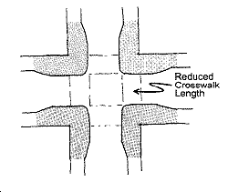
Corner bulbs reduce the crossing distance and provide more corner queuing space. The reduced crossing distance makes crossing safer, while the increased queuing area reduces the corner overcrowding that often spills into the street. Care should be taken not to constrain the movement of bicycles and transit vehicles in the design of sidewalk bulbs. Corner bulbs should be designed to shorten crossing distance and enhance visibility to the maximum extent possible while still retaining necessary vehicle movements.
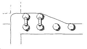
POLICY 24.7
Ensure safe pedestrian crossings at signaled intersections by providing sufficient time for pedestrians to cross streets at a moderate pace.
The timing and length of traffic signals should be set to provide enough "green" time for all pedestrians to cross streets safely. Timing should account for people using wheelchairs and carriages, where use of curb cuts is necessary for access to the crosswalk from the sidewalk. On wide streets, pedestrian islands should be established as necessary to provide slower-moving pedestrians with some relief and a waiting area. U-turns permitted at intersections with large pedestrian volumes should be reconsidered in the interest of improving pedestrian safety.
POLICY 24.8
Support pedestrian needs by incorporating them into regular short-range and long-range planning activities for all city and regional agencies and include pedestrian facility funding in all appropriate funding requests.
Pedestrian issues are affected by decisions in a variety of agencies and need to be considered. A number of local and regional agencies and departments plan transportation projects, which are increasingly developed as multi-modal projects, could incorporate pedestrian improvements. In particular, local and regional mass transit projects must pay particular attention to pedestrian needs, especially at significant transfer points. For many transportation projects, pedestrian improvements could be included with the project for far less than if the pedestrian project was a stand alone project. In general, the larger the project, the more potential to address pedestrian needs.
POLICY 24.9
Implement the provisions of the Americans with Disabilities Act and the city's curb ramp program to improve pedestrian access for all people.
Consideration of special pedestrian and wheelchair access should be given to areas and crosswalks where there is a large concentration of seniors and persons with disabilities. Design of streets should follow the principles of “universal design” where practicable. Universal design is a best practice that seeks to serve the needs of individuals with disabilities while providing cross-benefit to all users. Curb ramps should be provided at all crossings, prioritized based on the City’s ADA Transition Plan for Curb Ramps and Sidewalks.
POLICY 24.10
Maintain a presumption against the use of actuated pedestrian signals.
Actuated pedestrian signals favor motor-vehicle traffic over pedestrians, and are relatively uncommon in San Francisco. Where they do occur, the signal must be triggered to secure enough time to cross. Otherwise, only a very short time is allocated -- for cross traffic, not pedestrians. As such, demand-activated traffic signals present an inconvenience to pedestrians and should not be used on streets except where there is a need to prioritize transit or there is no significant pedestrian traffic.
OBJECTIVE 25
IMPROVE THE AMBIENCE OF THE PEDESTRIAN ENVIRONMENT.
POLICY 25.1
Preserve existing historic features such as streetlights and encourage the incorporation of such historic elements in all future streetscape projects.
Historic street lights impart a sense of history and character and can create continuity in the public realm even as the surrounding built environment changes over time. Historic street lights such as the Path of Gold (Market Street) lights and Golden Triangle (Mason/Powell) lights should be preserved, and restored as funding allows, according to the Secretary of the Interior's Standards. New street improvements should be designed to be compatible with the character of historic street lights and other existing historic streetscape elements.
POLICY 25.2
Maintain and expand the planting of street trees and the infrastructure to support them.
Street trees are the organizing element of the pedestrian environment. Locations for street trees should be identified and other streetscape elements placed in relation to existing or potential street tree planting locations, so as not to remove opportunities for planting new trees. Street trees provide shade, create a human scale on the street, soften the edge between the building and the street, and serve as a buffer between pedestrian space and the street. Moreover, street trees are an important environmental consideration as they contribute to cleaner air. An appropriate program of irrigation and maintenance should be implemented with street tree planting.
POLICY 25.3
Install pedestrian-serving street furniture where appropriate.
Street furnishings, including seating, should be provided according to the appropriate guidelines for the relevant street type. Higher concentrations of street furnishings are appropriate on downtown and commercial streets, near major civic or institutional uses, and adjacent to transit stops. Street furnishings may also be located in less active areas where there is a need to provide neighborhood open space, and the possibility for people to use and care for the space.
POLICY 25.4
Preserve pedestrian-oriented building frontages.
Building frontages that invite people to enter, that provide architectural interest and a sense of scale, and that are transparent enough to provide visual connections to and from the sidewalk help make the pedestrian environment more agreeable and safe.
POLICY 25.5
Where consistent with transportation needs, transform streets and alleys into neighborhood-serving open spaces or “living streets” by adding pocket parks in sidewalks or medians, especially in neighborhoods deficient in open space.
Public open space gives neighborhoods their identity, a visual focus, and a center for activity. San Francisco's streets and alleys play a key role in the City’s open space network – streets comprise approximately 25% of the city’s overall land. In many neighborhoods currently underserved by open space there is little opportunity to create significant new parks due to a lack of available land. In high-density areas, streets and alleys afford the greatest opportunity for new public parks and plazas.
In these areas, the city should create“living streets:” streets transformed into neighborhood-serving open spaces. In many locations, historic development patterns and the intersection of street grids result in excessive but unusable pavement spaces (called “pork chops” to describe a common shape). Similarly, many city streets are designed for more traffic than actually uses them.
These excess paved areas should be converted to pocket parks on widened sidewalks, curb extensions or new medians in appropriate circumstances. Pocket parks are small, active public spaces created in the existing public right-of-way. In addition to landscaping, pocket parks may include features such as seating areas, play areas, community garden space, or other elements to encourage active use of the public open space.
OBJECTIVE 26
DEVELOP AND MAINTAIN A MAP OF KEY WALKING STREETS
POLICY 26.1
Identify Key Walking Streets to be defined by the factors that contribute to high concentrations of people walking.
Key Walking Streets are defined by street segments in close proximity to significant pedestrian generators such as transit stops, schools, parks, tourist activities and shopping districts. Key Walking Streets are also defined by street segments in neighborhoods where there is more dependence on walking as a means of transportation, due to demographics, street slope, and/or limited access to transit or private automobiles.
POLICY 26.2
Prioritize safe and convenient walking as a mode of travel on Key Walking Streets. Ensure a high level of pedestrian quality and safety, and give sufficient right-of-way space to pedestrians.
POLICY 26.3
Prioritize funding for streetscape and pedestrian improvements on Key Walking Streets
POLICY 26.4
Design pedestrian improvements on Key Walking Streets consistent with the principles and guidelines for the appropriate street type in the Better Streets Plan and other adopted plans.
Pedestrian Enclaves
The City can also improve portions of public rights-of-way to improve neighborhood character and provide open space improvements on portions of streets by establishing “pedestrian enclaves.” Pedestrian enclaves are defined by location rather than size; enclaves should utilize portions of the street and should establish broad corner bulb-outs. They should provide either restful space for pedestrians to enjoy a moment of reflection or active space such as open air weights or a dog obstacle course. In all cases, the design of the space should be mindful of adjacent activities and uses. In most cases enclaves should include benches, landscaping, and should improve the streetscape environment. A vista, garden, or streetscape view should be included to provide the user with a springboard for reflection. Examples of pedestrian enclaves include bulb outs on Noe Street north of Market Street, Octavia Square at the base of Octavia and Market, and could include programming on some major transit plazas. Pedestrian enclaves serve a very localized population.
POLICY 26.5
Develop streetscape and public realm plans for areas with high pedestrian activity in collaboration with community members.
OBJECTIVE 27
EMPLOY A MULTI-DISCIPLINARY APPROACH TO IMPROVING PEDESTRIAN SAFETY
POLICY 27.1
Identify locations of high pedestrian injuries and fatalities based on available pedestrian safety data and established methodologies.
POLICY 27.2
Prioritize funding for pedestrian safety programs and improvements at high injury locations.
POLICY 27.3
Apply best practices in pedestrian safety education and enforcement to improve knowledge and awareness of pedestrian safety for the public and decision makers across the City.
POLICY 27.4
Apply best practices in street design and transportation engineering to improve pedestrain safety across the City.
POLICY 27.5
Focus enforcement on the top violations that most greatly affect pedestrian safety and at locations of high pedestrian injuries and fatalities.
OBJECTIVE 28
CONSIDER THE SIDEWALK AREA AS AN IMPORTANT ELEMENT IN THE CITYWIDE OPEN SPACE SYSTEM.
POLICY 28.1
Retain streets and alleys not required for traffic, or portions thereof, for through pedestrian circulation and open space use.
Small streets and alleyways play an important role in the citywide open space system, particularly in areas that are deficient in open space. They should be designed to prioritize the full use of the right-of-way for pedestrians, while accommodating small numbers of slow-moving vehicles where appropriate. Such shared public ways should have appropriate pedestrian and open space elements, traffic calming features, and detection cues for persons with visual impairments or other disabilities.
POLICY 28.2
Partially or wholly close certain streets not required as traffic carriers for pedestrian use or open space.
POLICY 28.3
Encourage pedestrian serving uses on the sidewalk.
Outdoor café and restaurant seating, merchandise displays, and food vendors all serve to enliven the pedestrian environment. Such uses should be encouraged on appropriate street types, consistent with established guidelines for safety, accessibility, and maintenance.
POLICY 28.4
Encourage and support the development of walking tours incorporating signage wherever possible.
There are a number of organized and semi-organized walking tours in the City supported by both private and public entities. Coordination and recognition of these walking tours should be encouraged and, utilizing an idea popular in other cities, signage or markers to direct pedestrians along prominent walking routes should be considered and implemented.
Bicycles
The bicycle is a desirable alternative to the automobile as a means of urban transportation in San Francisco. It can successfully be used for most transportation needs, including commuting, shopping, errands, and recreation. Active encouragement of bicycle use as an alternative to automobile use, whenever possible, is essential in light of the continually increasing traffic congestion caused by motorized vehicles which aggravates air pollution, increases noise levels and consumes valuable urban space. The bicycle is a practical and economical transportation alternative which produces no emissions or noise. In addition, each bicycle user enjoys health benefits through increased physical activity.
To enable a large number of San Franciscans to use the bicycle as a transportation option, several significant needs must be met. The needs include, among others, safe and comfortable space on the roadway for bicyclists, a system of identifiable bicycle routes that will direct bicyclists to major destinations, safe and secure bicycle parking, enforcement of laws protecting and regulating cyclists' rights, safety and responsibilities, and education of both the bicyclists and motorists about the safe sharing of the roadways.
OBJECTIVE 29
ENSURE THAT BICYCLES CAN BE USED SAFELY AND CONVENIENTLY AS A PRIMARY MEANS OF TRANSPORTATION, AS WELL AS FOR RECREATIONAL PURPOSES.
Refer to the 2009 San Francisco Bicycle Plan as a guide for achieving this objective.
POLICY 29.1
Expand and improve access for bicycles on city streets and develop a well-marked, comprehensive system of bike routes in San Francisco.
It is essential that the city have a system of bike routes which provide safe and reliable through travel to all areas of the city. These bike routes will necessarily be mostly on city streets, will provide space for the bicyclist, and may or may not have bicycle lanes or other markings which separate the bicyclist's space from the automobile driver's space. The bicycle routes should be clearly identified, with signage, for motorists, bicyclists and pedestrians. They should conform to the standards of the most recent California Highway Design Manual or the American Association of State Highway and Transportation Officials (AASHTO) in its "Guide for Development of Bicycle Facilities," whichever is more rigorous. Use of these guides will provide maximum opportunity to qualify for state and federal funding and will assist in avoiding city liability based upon design. Advisory and permissive guidelines should be observed whenever possible.
The Bicycle Route Network should provide efficient access from all neighborhoods to the many popular business, cultural, entertainment, and educational destinations in the city, and between those destinations. Special attention should be paid to commuters to the downtown areas, connections to the regional bicycle network, and the identification of recommended routes to school for students. Nevertheless, bicycle access must be provided, and enhanced if necessary, whether or not the streets are designated as "bike routes," to enable all residents and visitors to use bicycles as a viable means of transportation.
Where possible, opportunities should be taken to develop bicycle-priority corridors, such as veloways (bicycle-only facilities), bicycle boulevards and any other innovative solutions to improve bicycle transportation space within the city.
POLICY 29.2
Develop a rational classification system of bicycle preferential streets.
The bicycle preferential streets system should consider the multi-modal functions of the street, the topography, and the existing and potential volume of bicycle traffic on the street. Streets and pathways in the bike route system that are relatively level, do not have conflicts with high volumes of pedestrian traffic, and do not have the primary functions of freight routes, major arterials and primary transit streets should be designed and treated to prioritize the movement of bicycles. Other streets and paths on the bike route system should be designed and treated to balance the other modes of transportation with the movement of bicycles.
As with transit preferential streets, general traffic should be routed away from the bicycle preferential streets system wherever possible, except when they are arterial streets. Note that some bicycle preferential streets may have to be primary or secondary arterials or transit preferential streets, if feasible alternatives do not exist. In general, bicycle preferential streets should include design treatments that encourage all segments of the population to bicycle, not only experienced cyclists.
POLICY 29.3
Remove conflicts to bicyclists on all city streets.
City departments should give particular attention to eliminating conflicts on the Bicycle Route Network routes. Conflicts which may be inconsequential to automobiles can be disruptive, disabling, or even life threatening to bicyclists, and are often contributing factors in collisions involving bicyclists. Design elements such as sewer grates parallel to travel, unpaved or poorly paved shoulders, rough and/or obsolete railroad tracks (especially those crossing bicyclists paths at a diagonal), and conventional speed bumps all pose conflicts for cyclists and should be removed. Intermittent disruptions such as uneven road surfaces, cracks and pot holes, and refuse such as broken glass should be removed promptly. The city should give increased attention to maintenance and more frequent cleaning to Bicycle Route Network streets because of the increased needs of cyclists for a debris-free road surface. Bicycle routes should be well lit. Although priority shall be given to bicycle routes, conflicts to cyclists should be eliminated on all city streets.
POLICY 29.4
Maintain a presumption against the use of demand-activated traffic signals on designated bicycle routes.
Demand-activated traffic signals favor motor-vehicle traffic over bicyclists and pedestrians, and are relatively uncommon in San Francisco. Where they do occur, the signal must be triggered to secure enough time to cross. Otherwise, only a very short time is allocated -- for crossing motor vehicle traffic, not bicyclists. As such, demand-activated traffic signals present an inconvenience to bicyclists.
POLICY 29.5
Make available bicycle route and commuter information and encourage increased use of bicycle transportation.
San Francisco's healthful climate and compactness make travel by bicycle practical, but cyclists need to know the most efficient ways to traverse the city's many hills. Optimum routes exist to cross all areas of the city by bicycle, but these routes must be identified to the public. The city should provide route maps to enable potential bicycle commuters and others using the bicycle for transportation to find the most efficient routes to their destinations. Such maps should also identify recreational bicycle routes, including the San Francisco portions of the Ridge Trail and the Bay Trail.
Where appropriate, methods of identifying bikeways will include a clear, efficient system of bicycle route signs. Destination directions should be indicated with each sign.
POLICY 29.6
Accommodate bicycles on local and regional transit facilities and important regional transportation links wherever and whenever feasible.
The ability to integrate bicycle use and regional transportation systems is essential to maximizing the bicycle's transportation utility. The Bay Area is fortunate to have a number of quality public transportation services. The expansion of bicycle access on each of these systems increases the bicycle's range and usefulness and further decreases the number of auto trips made in the Bay Area.
Every effort must be made to maximize bicycle access on BART, CalTrain, all ferry systems, and on AC Transit, SamTrans and Golden Gate Transit buses and on selected Municipal Railway routes. Further, CalTrans shuttle service across the Bay Bridge should be expanded so it is available at all hours. Twenty-four hour access to all Bay Area bridges is essential to maintain these vital links within the bicycle transportation system.
Many commuters to San Francisco work outside of downtown and drive alone, contributing to peak hour congestion. If regional transit expanded peak hour bicycle capacity and reduced peak hour bicycle time restrictions, these commuters could bicycle to and from transit at one or both ends of their transit trip - an attractive choice to driving alone. This would also reduce parking demand at BART stations and park-and-ride lots.
POLICY 29.7
Include bicycle facility funding in all appropriate requests.
Bicycle transportation funding should be integrated into all appropriate state and federally funded transportation projects, especially those related to safety, transportation, recreation, and mass transit. Funds earmarked specifically for bicycle facilities should be pursued, based on an identified list of priority projects. Transportation planning should be integrated to include consideration of present and potential bikeways in all analyses.
POLICY 29.8
Encourage biking as a mode of travel through the design of safer streets, education programs and targeted enforcement.
Streets should be designed to incorporate effective safety measures to help people to bike safely and comfortably across the City.
Education of bicyclists and appropriate training should be made available at a wide variety of sources. These may include education of employees at work sites as part of alternative transportation education, to students at schools and colleges, and to new riders through bicycle shops and dealers.
Cars that fail to use turn signals, park in bike lanes, travel at excessive speeds and car passengers which open doors without looking pose serious threats to the safety of bicyclists. Education of motorists, bicyclists and the public should be actively and vigorously pursued. Such avenues may include billboards and public service messages, motor vehicle licensing procedures, traffic schools, and driver education and driver training courses. The cyclist's equal right to the road, as well as the responsibilities in using this access, should be emphasized.
Traffic enforcement should extend to protection of bicyclists' rights-of-way which are often violated by motorists. Special emphasis also needs to be placed upon theft prevention and investigation. Special training for police officers concerning bicycle-related laws and concerns should be included in their academy and in-service training.
POLICY 29.9
Identify and expand recreational bicycling opportunities.
Although many of the commuter routes will also serve recreational cyclists, such as those accessing tourist attractions and natural and scenic areas, other routes should be designed to accommodate recreational cyclists. Special attention should be paid to identify and map popular recreational destinations which may not be on regular through commuter routes, such as around Lake Merced, routes to the zoo, or parts of the Bay Trail and the Ridge Trail. Such routes should also be designated on the bicycle route map developed for San Francisco.
POLICY 29.10
Accommodate bicycles in the design and selection of traffic control facilities.
As the application of new technology to traffic control increases, traffic engineers more frequently are using automatic sensing devices to detect, count and monitor traffic and to control traffic signals, signal timing, and other traffic control devices. The technology of such sensing devices should be improved to detect and respond to the presence of bicycles as they use the roadway.
POLICY 29.11
Ensure completion of the Bay and Ridge Trails in San Francisco.
The Bay Trail is a planned 500-mile hiking and bicycling trail that will form a continuous loop around San Francisco Bay and San Pablo Bay, linking the shorelines of nine counties and 47 cities. The trail functions as a regional recreational and commute route along the edge of the bay and across seven toll bridges. Over 250 miles are complete, but there are numerous gaps to fill.
The Bay Trail alignment in San Francisco is part of the city bicycle network extending 20 miles along the length of the city shoreline from the Golden Gate Bridge to Candlestick Point State Recreation Area. Approximately 12 miles are complete. Improving the remaining segments will ensure designated bicycle access along the shoreline of the city linking the city bicycle network to adjacent counties and the regional trail system.
The Bay Area Ridge Trail is another regional trail that is being developed in the Bay. The trail is envisioned as a 550+ mile recreational trail encircling San Francisco Bay that is aligned along the ridge tops. The Bay Area Ridge Trail ultimately will be a 550+ mile trail encircling the San Francisco Bay along the ridge tops. The Ridge Trail is open to hikers, bicyclists and in some areas is available for equestrian use. Approximately 310 miles of the Ridge Trail have been dedicated for public use, but there are significant gaps to fill.
In San Francisco, much of the Ridge Trail is in place, primarily running on public rights-of-way and use is limited to pedestrians, hikers and bicyclists. The Ridge Trail alignment links a number of parks in San Francisco, primarily those along the City’s primary ridgeline and hilltops, including Twin Peaks, the Golden Gate Panhandle, and the Presidio. The trail alignment continues across the Golden Gate Bridge, establishing the connection with the Bay Area Ridge Trail in Marin County and the North Bay. While the trail alignment is in place in San Francisco, improvements to Ridge Trail segments in San Francisco would improve the City Bicycle and Pedestrian trail network as well as the regional trail network in Cities and Counties throughout the Bay Region.
OBJECTIVE 30
PROVIDE SECURE AND CONVENIENT PARKING FACILITIES FOR BICYCLES.
Theft and vandalism of locked bicycles is a major problem in San Francisco. This ever-increasing threat is a significant deterrent to increased bicycle use. Cyclists will use their bicycles more frequently, and for more different types of trips, if they have a secure and reasonably convenient parking facility at their destination. Adequate parking is crucial to the increased and continued use of bicycles.
POLICY 30.1
Provide secure bicycle parking in new governmental, commercial, and residential developments.
Bicycle parking should be provided in all new public and private buildings. The Planning Code should provide clearer regulation, guidance and exemptions for bicycle parking, as well as the necessary monitoring and enforcement of requirements. Review, update, and consolidate the Planning Code criteria for bicycle parking in garages and new or remodeled government and commercial buildings. The Planning Code should be reviewed to reconcile contradictions, and amended to forge a more comprehensive approach to bicycle commuting facilities. This approach should include such elements as expanded shower access and improved commercial district bicycle parking unbundled from automobile parking space requirements. The Planning Code should require a greater residential bicycle parking requirement, structured as a ratio of dwelling units rather than as a ratio of auto parking spaces.
In order to provide additional storage options to bicyclists, consider requirements that building owners allow tenants to bring their bicycles into buildings unless Class I bicycle parking is provided. In addition, consider requirements for bicycle parking in each individual building of large, multiple-building developments.
POLICY 30.2
Provide secure bicycle parking at existing city buildings and facilities and encourage it in existing commercial and residential buildings.
The city should encourage the owners of existing commercial and residential buildings to provide safe and secure bicycle parking, and encourage such building owners to provide storage lockers and shower facilities where feasible.
Managers of city buildings and other city facilities should endeavor to provide safe and convenient bicycle parking facilities at these locations. Storage lockers and shower facilities should be provided where feasible.
POLICY 30.3
Provide parking facilities which are safe, secure, and convenient.
Bicycle parking facilities must provide reliable security, adequate bicycle support, safety, and must be conveniently located. Bicycle parking facilities are preferably located where bicycles are sheltered from the weather and visible to attendants and security guards, accessible (such as by key or code) only to those who have parked bicycles, or located entirely inside non-garage parts of the building. If these resources are present, bicyclists will use such bicycle parking in increasing numbers.
Proper bicycle parking design is critical to its usefulness and effectiveness. Bicycle parking must be of a design to support the bicycle without damage and permit at least the frame and one wheel to be locked with a U-lock, but provide reasonable security with any type of lock. Bicycle parking facilities should be conveniently located at building entrances, provide sufficient space for access, and be physically separated from automobile areas. Bicycle parking in publicly-accessible garages should be well signed to notify the public of the presence of bike parking (e.g., at garage entrances and other appropriate locations), as well as direct cyclists to the location of the parking. Also, maintain a SFMTA bicycle parking outreach campaign in various formats to provide relevant bicycle parking information such as garage locations with bicycle parking and bicycle locker availability.
Prepare additional guidelines for the placement and design of bicycle parking within City rights-of-way, including curbside on-street bicycle parking where feasible, and “sleeve” ring racks on parking meters.
POLICY 30.4
Provide bicycle parking at all transit terminals.
Enabling bicycle access to transit connections encourages transit use and further decreases automobile use. In order for cyclists to consider using bicycle transportation to go to and from bus terminals, BART stations, train stations, ferry terminals, and park-and-ride lots, such locations must provide safe and secure bicycle parking. Such parking should be ample and should be of a high security type.
POLICY 30.5
Provide bicycle parking at major recreational facilities and at all large sports, cultural, or other heavily attended events.
Provide convenient, secure, and inexpensive bicycle parking at major recreational facilities and large sports, cultural, or other heavily attended events to encourage bicycle use and further decrease automobile use. In order for cyclists to consider using bicycle transportation to go to and from these facilities and events, safe and secure bicycle parking must be provided. Such parking should be ample and should be of a high security type. Free valet bicycle parking, such as provided at the baseball stadium, has proved very successful. Promotional materials for these events and facilities should highlight the provision of secure bicycle parking, especially if valet bicycle parking is provided.
POLICY 30.6
Provide for improved regulation of bicycle parking.
The Planning Code should provide for the citywide regulation of bicycle parking facilities. A comprehensive review of the existing regulatory structure could improve the monitoring of requirements in new and renovated buildings; existing parking garages requiring increased enforcement; city schools and local colleges; residential development requiring new ratios based on the number and occupancy of housing units and bedrooms; and city-owned and city-leased buildings requiring increased bicycle parking capacity. City leases should be negotiated to include the required level of bicycle parking through the efforts of the Real Estate Department and the MTA.
OBJECTIVE 31
CITY GOVERNMENT SHOULD PLAY A LEADERSHIP ROLE IN INCREASING BICYCLE USE.
City government should play a leadership role in enabling more people to use the bicycle as their primary means of transportation. According to the 2009 San Francisco Bicycle Plan, the city should provide the facilities, programs and regulatory structure to enable such use, and should encourage the use of bicycles for work trips as an alternative to city cars.
POLICY 31.1
Consider the needs of bicycling and the improvement of bicycle accommodations in all city decisions.
Genuine recognition and active accommodation of bicyclists' needs by all city departments in decisions related to transportation and land use is essential to the development of a significant bicycle transportation presence in San Francisco. Bicycle planning should be integrated into all short-range and long-range planning in all relevant City departments. Coordination between the Department of Parking and Traffic's Bicycle Program and other City departments should be improved. A working group should be created with representatives from relevant City departments, and should meet on a quarterly basis to discuss departmental and agency issues relevant to bicycle planning. In addition, periodic meetings should be held between the SFMTA and the Planning Department to update bicycle parking compliance status and review bicycle parking information.
Often, minor and inexpensive adjustments at a project's design phase can provide considerable benefits to bicyclists. Furthermore, inclusion of accommodations for cyclists when a project is designed can avoid expensive retrofitting later.
Through the cooperative efforts of the City’s Real Estate Department, the Planning Department, and the SFMTA, pursue a citywide policy that provides secure bicycle parking at all City buildings in areas to be specified by the individual agencies, subject to safety regulations and available space.
Coordination with the San Francisco Police Department (SFPD) should focus on making bicycle theft investigation a higher priority, creating a better system for returning recovered bicycles to their owners.
POLICY 31.2
Integrate bicycle planning into regular short-range and long-range planning activities for all city departments.
Every effort should be made to ensure that bicycle transportation is given thorough consideration in all planning activities. Full integration of bicycle transportation requires evaluation of the range of impacts which any transportation or development proposal may have upon bicycle use and bicyclists' safety. This applies not only to city departments but also to the various other entities whose activities affect mobility in San Francisco. Insofar as is possible, city departments should endeavor to develop an effective network of bicycle facilities and policies.
Ensure adequate and appropriate environmental review under the California Environmental Quality Act for the Bicycle Plan and all discretionary actions under the Bicycle Plan that may have a direct or indirect physical environmental impact. Consider updating the transportation impact guidelines to include analysis of bicycle-related issues when evaluating impacts of new projects.
Work with the responsible San Francisco agencies to collect where appropriate: bicycle counts; an inventory of existing bicycle parking within a two-block radius of the study site; and the project's potential impacts on any existing or proposed bikeways.
POLICY 31.3
Designate appropriate staff to coordinate all bicycle related activities.
A successful bicycle program requires cooperation among a variety of city departments, including the Departments of City Planning, Parking and Traffic, Public Works, the Chief Administrator's Office, the Public Transportation Department, and the Transportation Authority, as well as various State and other government agencies. Appropriate staff should be designated to be responsible for the coordination of bicycle-related activities to ensure that projects and plans that involve many departments are carried out effectively. Work with the responsible San Francisco agencies to collect where appropriate: bicycle counts; an inventory of existing bicycle parking within a two-block radius of the study site; and the project's potential impacts on any existing or proposed bikeways.
POLICY 31.4
Encourage non-cyclists to become cyclists and encourage cyclists to ride more often.
The city should create opportunities for new cyclists to have a positive bicycling experience, provide incentives for bicycle users, and promote public awareness and acceptance of bicycle transportation and recreational cycling. The city should establish programs to encourage bicycling by city employees including, where practical, for work-related travel, urge private employers to encourage and accommodate bicycle commuting (by providing, for example, incentives and parking, showers, and lockers), and encourage bicycle tourism through existing tourism promotion channels.
Citywide Parking
This section is organized to first address the Objectives and Policies related to parking citywide, then specifically to the distinct areas of downtown (primarily the area zoned C-3), and then the residential and commercial areas outside downtown.
OBJECTIVE 32
ENSURE THAT THE PROVISION OF NEW OR ENLARGED PARKING FACILITIES DOES NOT ADVERSELY AFFECT THE LIVABILITY AND DESIRABILITY OF THE CITY AND ITS VARIOUS NEIGHBORHOODS.
POLICY 32.1
Assure that new or enlarged parking facilities meet need, locational and design criteria.
A proposed parking facility should be evaluated as carefully as other proposed additions to the transportation system. Proposed new or enlarged facilities should be reviewed according to Master Plan policies, and Planning Code criteria for parking facilities. The facility should not be developed unless the following criteria are met:
-
There is a demonstrated demand for additional parking space in the surrounding area in relation to the supply provided or resulting from a specific development.
-
All or part of this demand cannot reasonably be diverted to or served by existing transit service or transit which could reasonably be provided in the near future.
-
This demand cannot be met by existing available facilities or more efficient use of existing facilities.
-
In the case of desired accessory parking (i.e. parking customarily provided incidental to a permitted use and directly related to the activities conducted on the site of the use) its need is clearly established and not presumed.
-
Provision of the facility does not result in the demolition of sound residential, commercial, and industrial buildings.
-
The traffic generated by the facility will not create a substantial adverse effect on the surrounding city streets (especially residential streets) and corridors leading into the city.
-
The facility, viewed in the local and citywide context of parking supplied and trips generated, will not discourage the possible diversion of current automobile users to transit.
-
The location is appropriate in terms of adjacent land uses.
-
The proposed site and facility are in close proximity to or readily accessible from freeway ramps or major arterials.
-
Conflict between pedestrian and bicycle movements and driveways or ramps is minimized and additional auto traffic through areas of heavy pedestrian concentration is avoided.
-
There is not substantial conflict with existing or future patterns of other forms of transportation, especially transit, and access avoids use of transit preferential streets.
-
Consideration has been given to the inclusion of other uses in order to maximize use of scarce land resources and integrate the structure into the surrounding neighborhood.
-
Access or egress is not primarily from streets or alleys having predominantly residential use.
-
When a parking garage is proposed, the structure is in scale with existing structures in the area, and when located in commercial districts includes commercial frontage in order to avoid blank street level facades.
-
The design and operating policy of the facility is such that vehicles can be admitted rapidly, to avoid the use of the street as a waiting area for entrance into the facility and to avoid the situation of automobiles idling for a long period of time.
-
A portion of spaces is reserved for compact automobiles and motorcycles.
-
Adequate provisions are made to accommodate parking and egress for people with mobility impairments.
-
Secure, convenient bicycle parking is provided.
-
All or portions of the facility are convertible to other uses if demand for parking is reduced in the future.
-
An equity program for patrons and employees who do not use auto parking facilities is offered at establishments where private auto parking is validated or subsidized, such as the provision of transit fare validations or "cash-out".
-
All relevant provisions of the Traffic Code and the ADA are met.
POLICY 32.2
Discourage the proliferation of surface parking as an interim land use, particularly where sound residential, commercial or industrial buildings would be demolished pending other development.
As an integral part of the transportation system, the location of any parking supply must be evaluated in like terms to the location of any roadway or transit line. Where parking lots are temporary uses on land in the development process, autos are attracted to these areas, creating a travel pattern based on expected availability of parking, which creates even greater difficulties whenever such a temporary facility is eventually terminated.
POLICY 32.3
Maximize the efficient use of land devoted to parking by consolidating adjacent surface lots and garages into a parking structure, possibly containing residential, commercial or other uses.
This applies both to existing and planned parking facilities. Surface parking may be particularly undesirable when it results in the demolition of needed housing or inexpensive industrial space suitable for incubator industry.
POLICY 32.4
Restrict long term automobile parking at rapid transit stations in the city in favor of development of effective feeder transit service and enhanced access for pedestrians and bicyclists.
Many of the rapid transit stations in San Francisco are located in densely developed downtown areas or in residential or shopping areas where additional automobile impacts are undesirable. These stations are located in such a manner that they may generally be reached by San Francisco residents either by connecting transit by walking, or by bicycling. The commuter use of the automobile to park at a rapid transit station in San Francisco should be discouraged. While it is desirable to provide bicycle storage and parking facilities at rapid transit stations, long-term automobile parking facilities are undesirable because such facilities would attract automobile traffic and otherwise be disruptive to the neighborhoods where they would be located.
POLICY 32.5
In any large development, allocate a portion of the provided off-street parking spaces for compact automobiles, vanpools, bicycles and motorcycles commensurate with standards that are, at a minimum, representative of their proportion of the city's vehicle population.
POLICY 32.6
Make existing and new accessory parking available to nearby residents and the general public for use as short-term or evening parking when not being utilized by the business or institution to which it is accessory.
A major reservoir of parking spaces, accessory to particular businesses or institutions, is currently in use only during the daytime working hours of those particular businesses and remains vacant and inaccessible at other times. In many instances this space could be used in the evening by residents of the immediate neighborhood or their guests, and in the evening and on weekends by visitors and patrons of adjacent businesses that operate during those hours.
POLICY 32.7
Limit and screen from view from public access areas parking facilities over the water, and near the water's edge where such parking interferes with public access.
Where feasible, existing and proposed non-maritime parking facilities over or near the water's edge that impede public visual or physical access to the Bay should be removed or relocated.
POLICY 32.8
Consider lowering the number of automobile parking spaces required in buildings where Class I bicycle parking is provided.
OBJECTIVE 33
ESTABLISH PARKING RATES AND OFF-STREET PARKING FARE STRUCTURES TO REFLECT THE FULL COSTS, MONETARY AND ENVIRONMENTAL, OF PARKING IN THE CITY.
POLICY 33.1
Set rates to encourage short-term over long term automobile parking.
POLICY 33.2
Where off-street parking near institutions and in commercial areas outside downtown is in short supply, set parking rates to encourage higher turnover and more efficient use of the parking supply.
POLICY 33.3
Encourage equity between drivers and non-drivers by offering transit fare validations and/or cash-out parking programs where off-street parking is validated or subsidized.
OBJECTIVE 34
LIMIT PARKING IN DOWNTOWN TO HELP ENSURE THAT THE NUMBER OF AUTO TRIPS TO AND FROM DOWNTOWN WILL NOT BE DETRIMENTAL TO THE GROWTH OR AMENITY OF DOWNTOWN.
POLICY 34.1
Discourage new long-term commuter parking spaces for single-occupant automobiles in and around downtown. Limit the long-term parking spaces to the number that already exists.
POLICY 34.2
When it must be provided, locate any new long-term parking structures in the areas peripheral to downtown. Any new peripheral parking structures should be concentrated to make transit service convenient and efficient, connected to transit shuttle service to downtown, and provide preferred space and rates for van and car pool vehicles, bicycles and motorcycles.
POLICY 34.3
Encourage short-term use of existing parking spaces within and adjacent to downtown by converting all-day commuter parking to short-term parking in areas of high demand.
POLICY 34.4
Where residential streets that are adjacent to or within the downtown area are used for on-street, long-term commuter parking, implement measures to promote short-term parking and discourage long-term commuter parking.
POLICY 34.5
When the priority functions of service vehicle access and pedestrian movement are sufficiently accommodated on downtown alleys, the function of remaining alley space should be designated for motorcycle parking, primarily short-term.
OBJECTIVE 35
CONTAIN AND LESSEN THE TRAFFIC AND PARKING IMPACT OF INSTITUTIONS ON SURROUNDING RESIDENTIAL AREAS.
Many institutions already have physical expansions planned, and the employment levels projected indicate that institutions will have even greater traffic and parking impacts on residential areas unless strong efforts are made to accommodate the employment growth by transit or other alternatives to the automobile.
POLICY 35.1
Limit the provision of long-term automobile parking facilities at institutions and encourage such institutions to regulate existing facilities to assure use by short-term clients and visitors.
Although there are some trips to institutions which are appropriately made by automobile, especially for medical appointments and hospital visits, work trips should be made by transit wherever possible. Institutions should take effective measures to reduce the amount of traffic and parking generated by the development and should develop and implement transit action plans accordingly. In addition to the criteria for new parking facilities in Objective 30, Policy 1, new parking provided by institutions should be carefully designed to favor short-term, carpool or bicycle parking for trips which cannot reasonably be made on transit.
POLICY 35.2
Protect residential neighborhoods from the parking impacts of nearby traffic generators.
Residents should be given preference in the use of residential neighborhood on-street parking spaces where traffic congestion and parking shortages generated by institutions, schools, shopping districts, recreational facilities or rapid transit stations have contributed to the deterioration of the residential environment. The preferential parking concept may reduce parking congestion in residential neighborhoods caused by long-term non-residential parkers, facilitate residents access to on-street parking close to their homes, provide for access to convenient parking by visitors of neighborhood residents and allow convenient parking for vehicles being used by people providing essential services to neighborhood residents.
OBJECTIVE 36
RELATE THE AMOUNT OF PARKING IN RESIDENTIAL AREAS AND NEIGHBORHOOD COMMERCIAL DISTRICTS TO THE CAPACITY OF THE CITY'S STREET SYSTEM AND LAND USE PATTERNS.
The increasing level of vehicle ownership by city residents indicates the need for improved transit services throughout the city. It also indicates the need for parking facilities is continuing and raises serious questions about the level of automobile ownership which can be supported by the street and parking system. Since much of the city's housing, especially in the more densely developed areas, was built prior to the time when the automobile became the dominant mode of travel, off-street parking spaces do not exist in adequate numbers. The size of many streets and the need to provide free flows for traffic limits the number of on-street spaces. Just as the street system cannot accommodate all potential traffic, so the city cannot provide for an unlimited level of automobile storage. A reasonable level must be provided for and measures should be considered to discourage vehicle accumulations beyond that level.
POLICY 36.1
Regulate off-street parking in new housing so as to guarantee needed spaces without requiring excesses and to encourage low auto ownership in neighborhoods that are well served by transit and are convenient to neighborhood shopping.
Some neighborhoods have large numbers of persons using transit to go to work and have significant numbers of no-auto or one-auto households. This pattern should be encouraged and reflected in off-street residential parking requirements, and in the provision for safe, secure bicycle parking facilities for all residential units.
Use of common parking facilities for several buildings should be encouraged where existing buildings can be used for this purpose in nearby commercial areas. There may be a place for public provision and leasing of long-term resident parking in already developed parking facilities in high-density neighborhoods.
POLICY 36.2
Use existing street space to increase residential parking where off-street facilities are inadequate.
Local streets are of such width in many areas that improved parking conditions can be obtained by shifting from parallel to diagonal or perpendicular parking without a major investment. Care must be taken, however, to avoid conflicts with transit operations and safe bicycle movement (considering both adequate lane width and potential conflicts with vehicles backing out of parking spaces), and to ensure that the street is more than a parking lot. Proper landscaping is required to prevent lights from shining into dwellings at night and breaks in rows of cars should be provided to avoid the monotony and unsightliness of unending rows of vehicles. Back-in diagonal or perpendicular parking should be considered as an option to reduce bicycle-motor vehicle conflicts.
POLICY 36.3
Set maximum parking limits for off-street parking in new buildings commensurate with the level ofpublic transit access and in consideration of the land use density and mix of uses.
In order to facilitate an appropriate density of housing, commercial activity, and other uses, to encourage travel by modes other than single-occupant automobiles, and to reduce the cost of building new housing and other uses, San Francisco does not have minimum off-street automobile parking requirements for any uses citywide, and sets maximum limits for new development, generally expressed as a maximum ratio ofparking spaces per unit or square footage of non-residential use. Lower maximum limits should be set for areas in close proximity to high frequency and high capacity transit, such as local (e.g. Muni Metro) and regional (e.g. BART. Caltrain) rail stations and high quality rapid bus services, such as bus rapid transit. Higher density and mixed use areas with better transit service, such as areas crossed by multiple bus lines, should also be considered for lower parking limits. Maintaining these parking maximums is critical to reducing the cost of housing, controlling traffic congestion, limiting environmental impacts of vehicular travel (e.g. greenhouse gas emissions), and improving street safety for pedestrians and other vulnerable road users, and ma.x:imizing efficient use of maior public investment in transit infrastructure and services by encouraging transit ridership.
POLICY 36.4
Where parking demand is greatest in city neighborhoods, consider wide-scale transit improvements as an alternative to additional parking garages as part of a balanced solution.
A great demand for parking in city neighborhoods indicates that available transit services are insufficiently attractive or convenient. Transit improvements could not effectively relieve or replace the demand for expanded off-street parking unless they were extensive and well-connected to local crosstown and radial transit lines and regional transit.
POLICY 36.5
Minimize the construction of new curb cuts in areas where on-street parking is in short supply and locate them in a manner such that they retain or minimally diminish the number of existing on-street parking spaces.
It is desirable to maintain a balance in the supply of adequate on- and off-street parking. The creation of curb cuts to increase the supply of off-street parking often deprives the neighborhood of a community on-street parking space in exchange for a private one. New buildings may be designed so that entrances to off-street parking are pooled or configured to minimize curb cuts and preserve the supply of on-street parking. An increased number of curb cuts also increases the number of potential conflicts between motor vehicles and bicycles.
OBJECTIVE 37
MEET SHORT-TERM PARKING NEEDS IN NEIGHBORHOOD SHOPPING DISTRICTS CONSISTENT WITH PRESERVATION OF A DESIRABLE ENVIRONMENT FOR PEDESTRIANS AND RESIDENTS.
POLICY 37.1
Provide convenient on-street parking specifically designed to meet the needs of shoppers dependent upon automobiles.
Automobile use is often necessary for shopping trips involving the purchase of bulky items such as groceries or where there are many stops to be made at different places far apart. Where additional short-term parking is demonstrated to be needed and essential to a shopping district, it should be provided at the least economic and environmental cost to the neighborhood and the city. As an alternative, however, retail delivery services should be encouraged.
POLICY 37.2
Assure that new neighborhood shopping district parking facilities and other auto-oriented uses meet established guidelines.
In addition to the criteria for new parking facilities in Objective 30, Policy 1, the following guidelines should be considered in the review of proposed new facilities in Neighborhood Commercial Districts.
-
Parking Facilities should be located to provide convenient access to desired shopping destinations. However, they should be located in such a manner that lessens the amount of traffic traveling through the district, does not disrupt the continuity of the shopping district, and that neither gives it priority over nor impedes access to destinations for persons arriving by transit, bicycle or on foot.
-
Multiple use of parking structures and lots should be provided wherever feasible. The use of roof tops of garage structures as game/play areas in densely populated neighborhoods, use of surface parking lots as tennis courts or soccer fields on days when the shopping districts are closed, or use of the facilities for resident parking in the evening are all possibilities which should be considered.
-
The location and configuration of curb cuts and entrances to off-street parking should be designed to minimize safety hazards and access conflicts to pedestrians, transit operations and bicyclists, and to be sensitive to the design and scale of the urban streetscape.
Urban Goods Movement
This section is aimed at improving the movement of goods (as distinct from people) by all modes to, from, within, and through San Francisco. Although the Transportation Element is primarily focused on person movements, much of our public infrastructure for transportation serves the movement of both people and freight. Managing urban goods movement serves to enhance economic development, reduce traffic congestion, and contribute to other social goals. Adverse effects such as traffic accidents, noise, vibration, emissions and truck intrusion into residential areas are concerns which must be addressed.
These objectives and policies highlight issues related to intra-urban goods transport internal to San Francisco. This section also distinguishes between traffic with both origin and destination in the city's boundaries, such as unloading/pickup activities downtown, and goods transport of greater distances. The movement of goods to and from the San Francisco Bay Area involves other transportation modes in addition to roads, including intermodal freight terminals at port piers and backlands, rail terminals and airports. San Francisco in particular, with its peninsular location, poses complicated challenges in the development of routes, facilities and access points. Enhanced connections to consolidated intermodal terminals, multiple rail servers and regional highways are key to the efficient movement of goods.
Across the country and, in particular, for San Francisco, future trends in the movement of urban freight can be characterized as follows: An increasing suburbanization and containerization of urban freight warehousing; a growth in location dependent service industries; policy debate on the preservation of industrial zones; a move toward "just in time" production methods; customers demanding higher levels of capacity, frequency, punctuality, reliability and flexibility to accommodate the higher value of goods which modern industry is producing; a proliferation of commercial and courier vehicles; telecommuting and its potential impacts on the demand for courier and messenger services; increasing awareness and regulation of hazardous materials transport; rising costs of waste disposal; increased importance of infrastructure upgrades and the associated logistical problems; accelerated pressure for parking and curbside facilities; and a greater community concern about the impacts of the freight industry.
OBJECTIVE 38
PROMOTE FREIGHT DELIVERY/PICKUP TRAFFIC AS NECESSARY FOR THE ECONOMIC VITALITY OF SAN FRANCISCO AND THE BAY REGION.
POLICY 38.1
Support urban goods movement networks in San Francisco, especially in the areas reserved for industrial development and in neighborhood commercial districts.
POLICY 38.2
Coordinate with appropriate governmental agencies to anticipate and accommodate the needs of both local and through freight traffic in future growth areas in San Francisco.
POLICY 38.3
Encourage and facilitate the bicycle as a courier vehicle in congested areas, especially in the downtown area.
Bicycle messenger services are often the fastest, most efficient and most economical means of transporting small goods, particularly in the downtown area. Provisions for safe and comfortable bicycle -- as well as pedestrian -- movement should be made in the design and improvement of streets.
OBJECTIVE 39
CREATE A PHYSICAL AND ECONOMIC ENVIRONMENT CONDUCIVE TO THE EXPANSION OF SAN FRANCISCO'S INDUSTRIAL, MARITIME, AND AIRPORT ACTIVITIES BY ENSURING TRUCK/SERVICE VEHICLE AND RAIL ACCESS AND EGRESS TO THESE USES.
POLICY 39.1
Provide sufficient curbside and off-street facilities to rail, piers and air terminals where freight movement is dominant, and particularly where it conflicts with other transportation modes and functions.
POLICY 39.2
Improve and maintain intermodal rail freight handling capacity to the Port and other industrial areas by improving bridges and tunnels along the waterfront to accommodate all types of freight rail cargo.
POLICY 39.3
Enhance access and circulation between highways, freight facilities and intermodal transfer points on the waterfront for trucks and other service vehicles.
POLICY 39.4
Promote water-based transportation such as freight ferries and waterfront shuttles between San Francisco and other waterfront terminals around the Bay to supplement land-based modes of freight travel.
Shuttling freight across the bay by "freight" ferries between Bay Area ports and landside railheads allows for the transfer, staging and intermodal movement of goods at a greater number of Bay Area locations, including San Francisco. Such efforts would strengthen the ports of the region as a whole, and help make them competitive with other metropolitan ports on the West Coast.
OBJECTIVE 40
DEVELOP AND MAINTAIN SELECTED MAJOR AND SECONDARY ARTERIALS TO PROVIDE EFFICIENT AND DIRECT ROUTES FOR TRUCKS/SERVICE VEHICLES INTO AND THROUGH SAN FRANCISCO WITHOUT DISTURBING NEIGHBORHOOD AREAS AND INHIBITING THE SAFE MOVEMENT OF TRANSIT VEHICLES, BICYCLES AND PEDESTRIANS.
POLICY 40.1
Improve the existing regional network of truck routes by making designated routes in San Francisco convenient for non-local freight trips with the aim of making the routes direct and connected to other routes.
POLICY 40.2
Reduce truck trips through San Francisco that have origins and destinations outside the City and the peninsula by promoting viable alternate truck routes and access across bay bridges that are not as subject to traffic congestion as the Bay Bridge and the Golden Gate Bridge.
Many freight trips through the Bay Area that do not need to travel to San Francisco or the peninsula may be made more quickly and efficiently by taking routes such as 680 or I-5 that bypass the congested conditions of the bridges and freeways in the central Bay Area.
OBJECTIVE 41
MAKE FREEWAY AND MAJOR SURFACE STREET IMPROVEMENTS TO ACCOMMODATE AND ENCOURAGE TRUCK/SERVICE VEHICLE TRAFFIC IN INDUSTRIAL AREAS AWAY FROM RESIDENTIAL NEIGHBORHOODS.
POLICY 41.1
Establish and maintain advisory truck routes, with clear signage, between industrial areas and freeway interchanges to enhance truck access and to clearly and visibly attract truck traffic away from residential neighborhoods.
POLICY 41.2
Accommodate heavy vehicles with extra-legal loads on major truck routes by ensuring vertical clearances, appropriate intersection design for maneuvering and providing signal timing to allow smooth truck progression.
POLICY 41.3
Implement measures to reduce adverse affects from trucks/service vehicles and rail traffic by enforcing restrictions on certain routes, specific areas or times of day.
OBJECTIVE 42
ENFORCE A PARKING AND LOADING STRATEGY FOR FREIGHT DISTRIBUTION TO REDUCE CONGESTION AFFECTING OTHER VEHICULAR TRAFFIC AND ADVERSE IMPACTS ON PEDESTRIAN CIRCULATION.
POLICY 42.1
Provide off-street facilities for freight loading and service vehicles on the site of new buildings sufficient to meet the demands generated by the intended uses. Seek opportunities to create new off-street loading facilities for existing buildings.
One way to address deficiencies in freight- loading facilities for existing buildings is to make short-term parking for loading and deliveries a high priority use of adjacent curb space.
POLICY 42.2
Discourage access to off-street freight loading and service vehicle facilities from transit preferential streets, pedestrian-oriented streets and alleys, or on the Bicycle Route Network by providing alternative access routes to facilities.
POLICY 42.3
Off-street loading facilities and spaces in the downtown area should be enclosed and accessible by private driveways designed to minimize conflicts with pedestrian, transit, bicycle and automobile traffic.
POLICY 42.4
Driveways and curb cuts should be designed to avoid maneuvering on sidewalks or in street traffic, and when crossing sidewalks, they should be only as wide as necessary to accomplish this function.
POLICY 42.5
Loading docks and freight elevators should be located conveniently and sized sufficiently to maximize the efficiency of loading and unloading activity and to discourage deliveries into lobbies or ground floor locations except at freight-loading facilities.
POLICY 42.6
Encourage consolidation of freight deliveries and night-time deliveries in the downtown C-3 zoning districts to increase efficiency of freight movement and reduce congestion.
POLICY 42.7
Strictly enforce yellow and special truck loading zones throughout San Francisco to facilitate delivery/pickups and reduce traffic congestion caused by double-parking.
POLICY 42.8
Provide limited curbside loading spaces to meet the need for short-term courier deliveries/pickup.
One of the major sources of transit operation and traffic conflicts is the extent of double-parking by courier services and other short-term delivery vehicles. Places of business that use courier service extensively should accommodate deliveries, pick-ups and drop-offs through the provision of on-street or off-street parking and loading space.
POLICY 42.9
Where possible, mitigate the undesirable effects of noise, vibration and emission by limiting late evening and early hour loading and unloading in retail, institutional, and industrial facilities abutting residential neighborhoods.
This policy presents conflicts that need to be worked out on a case-by-case basis as a balance between the livability of these residential neighborhoods and goods movement activity. In certain areas, deliveries may be confined to early evening post-peak hours without difficulty, but on the other hand, intensive truck traffic and freight rail movement must occur during off-peak hours because of congestion on highways and shared passenger/freight rail facilities during the day.
Amendments by Board of Supervisors Ordinance 0298-04 adopted on 12/14/2004.
Amendments by Board of Supervisors Ordinance 0109-05 adopted on 06/07/2005.
Amendments by Board of Supervisors Ordinance 0125-05 adopted on 06/21/2005.
Amendments by Board of Supervisors Ordinance 0246-07 adopted on 10/23/2007.
Amendments by Board of Supervisors Ordinance 0188-09 adopted on 08/11/2009.
Amendments by Board of Supervisors Ordinance 0072-09 adopted on 04/28/2009.
Amendments by Board of Supervisors Ordinance 0203-10 adopted on 08/03/2010.
Amendments by Board of Supervisors Ordinance 0309-10 adopted on 12/07/2010.
Amendments by Board of Supervisors Ordinance 0097-11 adopted on 06/14/2011.
Amendments by Board of Supervisors Ordinance 0143-11 adopted on 07/12/2011.
Amendments by Board of Supervisors Ordinance 0185-12 adopted on 07/31/2012.
Amendments by Board of Supervisors Ordinance 0182-13 adopted on 07/30/2013.
Amendments by Board of Supervisors Ordinance 0151-14 adopted on 07/22/2014.
Amendments by Board of Supervisors Ordinance 0175-17 adopted on 07/25/2017.
Amendments by Board of Supervisors Ordinance 0274-18 adopted on 11/13/2018.
Amendments by Board of Supervisors Ordinance 0064-20 adopted on 04/21/2020.
Amendments by Board of Supervisors Ordinance 0243-25 adopted on 12/09/2025.