NorthEastern Waterfront Area Plan
NOTE: Please note that the Objectives and Policies of this 1998 version of the Northeastern Waterfront Plan were renumbered.
INTRODUCTION
Background
San Francisco is a compact city, surrounded on three sides by the Pacific Ocean and San Francisco Bay. From the beginning, the waterfront has played an intimate role in the City's industrial, commercial, and recreational life.
San Francisco has long served as a gateway to newcomers venturing to North America for the first time due to its protected harbor. Originally home to the Ohlone, San Francisco attracted people of European ancestry and other non-natives looking for a new life and a new place to call home. Europeans – specifically Spaniards – first settled in San Francisco Bay in 1776; however, it was not until the 1849 gold rush that the region had its first wave of significant settlement and population growth by Europeans. As with all of the Americas, prior to western settlement, this land had been the home of indigenous peoples who had maintained harmony with the Bay’s ecology for millennia. When Juan Bautista de Anza arrived, this was the home of the Yelamu, a subgroup of the Ramaytush-speaking group of the Ohlone people. Settlement of people of European ancestry in San Francisco generally followed settlement patterns of the Ohlone. For example, Spanish colonists did not lay their plans on a blank canvas, as the natural landscape dictated the placement of both the Presidio and the Mission. Both were situated near sources of drinking water, and both avoided the vast fields of sand dunes. Because it was meant to protect the Bay, the Presidio overlooked the Golden Gate. Because it was supposed to produce food, the Mission overlooked sunny grasslands. Spanish colonists also built on the settlement patters of those they sought to colonize. Through the lens of settler colonialism, these echoes of indigenous patterns on the land are still visible in today’s City. In the Northeastern Waterfront, European settlement growth was in the area adjacent to the Bay where deep and protected waters provided a natural harbor.
This area is now the Northeastern Waterfront and includes Fisherman's Wharf to China Basin. Much of this area was developed on Bay fill as the original shoreline skirted the base of what are known as Telegraph, Rincon, and Potrero Hill.
During these early days of settlement by people of European ancestry, the waterfront was a lively part of town, busy with sailors and those hoping to earn their fortunes in the gold fields. City dwellers would stroll along the waterfront and enjoy the marvelous view of the Port and the Bay. The nearby hillsides were the sites of the earliest settlements and later became fashionable neighborhoods.
Through World War II, the waterfront retained its image as a thriving port and center of the City's economic vitality. The Ferry Building, located at the foot of Market Street, became a landmark structure symbolic of the City's ties with the Bay Area and the World. The western half of San Francisco's waterfront, from Aquatic Park, west to the Presidio and south along Ocean Beach to the County line was developed for military and recreational use and in recent years has become part of the magnificent Golden Gate National Recreational Area.
With the passage of time, however, the Northeastern Waterfront became increasingly separated from the rest of the city and began to decline in activity. The completion of the Bay Bridge in the 1930's foreshadowed the decline of the Trans-Bay ferry service and diminished the role of the Ferry Building. The construction of the Embarcadero Freeway and parking lots beneath it created visual and physical barriers to the Bay, impeding the revitalization of this part of the City.
Changes in transportation technology related to the movement of goods by water also contributed to the decline of the waterfront. The placement of cargo in standardized containers resulted in dramatic shifts in maritime transportation patterns. Container shipping shifted the emphasis from the traditional breakbulk method of cargo handling, for which the Port's finger piers were designed, and created the need for large modern facilities requiring considerable capital investment and backland support areas. In response, new container shipping facilities were developed in the central and southern waterfront near India Basin in the 1970's.
Although the Port of San Francisco was, at the end of World War II, the largest port in the region, the Port of Oakland was first to develop container shipping facilities. Oakland has the advantage of large, undeveloped flat land necessary for the storage of containers as well as better rail and highway connections to eastern markets than San Francisco. Some piers along San Francisco's Northeastern Waterfront continue to be used for cargo handling through the 1990’s. Other piers continue to be used in whole or part for commercial fishing, maritime support, cruises, excursions, ferries, and other commercial and recreational maritime operations, which will maintain a working waterfront presence. However, many of the underutilized piers and adjacent Port land which was no longer needed or suitable exclusively for industrial maritime operations have created opportunity for new maritime mixed use developments, recreation, public access, and open space.
In the 1960's, the gradual decline of cargo shipping and other industry changes led to economic and planning changes for upland properties west of The Embarcadero. Industrial and manufacturing businesses, and warehouses that extended from Fisherman's Wharf and south along the Sansome-Battery corridor into the South of Market became the focus of City planning to transform these areas to commercial and residential uses to complement the growing financial and business services center in downtown San Francisco. In addition, the San Francisco Redevelopment Agency established two redevelopment areas: 1) Golden Gateway, generally bounded by Front and Battery Streets on the west, Sacramento Street to the south next to downtown, Broadway to the north and The Embarcadero to the east; and 2) Rincon Point-South Beach, a two-part redevelopment area which includes an approximately three to four block area near the waterfront from Mission to Folsom Streets, and a larger nine block area on the waterfront from Bryant to Berry Streets which includes South Beach Harbor and Pier 40. These two redevelopment project areas sunset in 2021, after which land use authority was transferred to the Planning Department. The two areas were incorporated into the East SoMa Area Plan adopted in 2009. In 1985, the San Francisco Planning Commission adopted the Rincon Hill Plan for the area adjacent to the waterfront between Folsom and Bryant Streets, extending inland to Second Street; the Rincon Hill Plan was further updated in 2006. These three planned areas have been, or will be, redeveloped with a mix of activities, but predominantly of residential use with supporting commercial and business services.
Although plans for all three areas were developed when the Embarcadero Freeway was still in place, their proximity to the waterfront was regarded as a major amenity that could only be fully realized if the Freeway was removed. The General Plan therefore included policies calling for the removal of the overhead Embarcadero Freeway, to allow the City to be reunited with its waterfront. However, after the defeat in 1986 of a ballot proposition for the freeway removal, public efforts turned to defining transportation improvements that would transform the surface Embarcadero roadway from a largely industrial arterial to a grand urban boulevard.
Guided by policies contained in the Northeastern Waterfront Plan, in 1985 the City approved the blueprint for the $80 million Waterfront Transportation Projects, a series of improvements that together would improve The Embarcadero roadway from Fisherman's Wharf to China Basin, with widened sidewalks, public art, landscaping and other pedestrian amenities, a new F historic street car line from Market Street to Fisherman's Wharf, and a MUNI Metro light rail service extension from Market Street into the Mission Bay area.
The phased construction of these transportation enhancements was underway before the Loma Prieta Earthquake in 1989. In light of the extent of earthquake damage sustained by the Embarcadero Freeway and its extremely high repair cost, the City decided to demolish the double-decked structure and its connecting ramp system, which opened the City to the waterfront.
In the aftermath of the freeway removal, new unobstructed waterfront views from Downtown San Francisco and adjacent areas combined with the landscaping, lighting, public art and other pedestrian improvements underway along The Embarcadero reinvigorated public interest in revitalizing the waterfront. While there is substantial demand for a variety of uses on the Northeastern Waterfront, the type and magnitude of new uses should reflect what is desirable from the broadest public interest point of view. Although there is a desire to maintain and attract new blue collar jobs, this has become increasingly difficult in light of technological advances which have replaced manufacturing jobs, the moving of manufacturing functions overseas, the increased costs of land in the City, and traffic congestion on major travel corridors. In addition to office, industrial, services and shipping activities, a substantial portion of the City's economy is related to tourism. Hotel, restaurant and retail uses are large employers, particularly of people of color. There is a demand for additional commercial and tourist-related development, however it must be carefully balanced against the need for maritime uses, recreation and open space, the needs of new resident populations in the Northeastern Waterfront and the community desire not to replicate or compete with other tourist areas in the City.
Property under the jurisdiction of the Port of San Francisco, including all piers and certain inland sites in the Northeastern Waterfront, is subject to use limitations under the public trust and the Burton Act. The Port, as trustee, is required to promote maritime commerce, navigation and fisheries, as well as to protect natural resources and develop recreational facilities and activities to promote public use and enjoyment on these public lands.
In June 1997, the Port Commission adopted the Waterfront Land Use Plan, which was prepared pursuant to Proposition H, an initiative approved by San Francisco voters in 1990. Under Proposition H, the Waterfront Plan prioritizes maritime and water-dependent uses along the Port’s 7.5-mile waterfront, and sets forth policies that allow complementary non-maritime uses for properties under the Port’s jurisdiction, consistent with its public trust responsibilities and the Burton Act and the City's Northeastern Waterfront Plan. In 2023, following a lengthy public process, the Port produced a comprehensive update of the Waterfront Plan. The Waterfront Plan goals describe the public values and set the policy foundation for the plan, including: 1) to maintain and improve the working maritime waterfront; 2) to provide a diversity of activities that provide equitable benefits to people and communities that historically have been marginalized and not included in public discussions about the waterfront; 3) to maintain and improve a connected network of parks and public access to and along the waterfront; 4) to respect and enhance unique maritime historic resources and urban design worthy of the waterfront setting; 5) to promote economic and recreational access that includes people of all races, ages, and social backgrounds; and 6) to partner with the community, sponsors, and public agencies to advance environmental sustainability and adaptation of the waterfront to climate change and sea level rise. The Waterfront Plan includes general land use policies for maritime uses, open space and public access, residential and commercial uses, other uses and interim uses, and identifies unacceptable non-maritime land uses. It includes five subarea plans, of which three are entirely within the area covered by the Northeastern Waterfront Plan.
The San Francisco Bay Conservation and Development Commission (BCDC) has jurisdiction over San Francisco Bay and upland areas within 100 feet of the shoreline under the McAteer-Petris Act. BCDC adopted the San Francisco Bay Plan as called for under that legislation, which establishes BCDC policies for San Francisco Bay. To provide more dedicated policy focus for piers and properties along the San Francisco Waterfront, BCDC worked in concert with the Planning Department and Port to adopt the San Francisco Waterfront Special Area Plan in 1975. The Special Area Plan, together with the McAteer-Petris Act and the Bay Plan set forth BCDC policies and conditions for water-dependent uses, and non-maritime uses on piers and shoreline properties along the San Francisco Waterfront. The Port works with BCDC and the City on periodic amendments to City and BCDC plans to update and maintain alignment between the policies of all three agencies.
Within the context of this regulatory framework and the strong caring interest that San Francisco's residents and workers have for the City, the Port's Waterfront Plan sets forth goals and policies that have guided many waterfront improvements to complement the transformation of The Embarcadero. New waterfront parks and an expanded public access system have been created. The iconic finger piers and arched bulkhead buildings, together with the Ferry Building and Agriculture Building, are included in the Embarcadero Historic District, which was listed on the National Register of Historic Places in 2006. The historic rehabilitation of the Ferry Building and several historic piers and development of a ballpark for the San Francisco Giants have created new attractions and activities that make the waterfront a worldwide destination. The investments include major new maritime facilities, including the James R. Herman Cruise Terminal at Pier 27, and the development of the Downtown Ferry Terminal, which provides a new major regional public transit service in the Bay Area. The Waterfront Plan also includes an implementation process for major development projects which involves soliciting early community input on conceptual development programs for specific sites before the Port issues requests for major new development proposals. Further, an interagency design review committee including Planning Department, Port and San Francisco Bay Conservation and Development Commission representatives reviews projects to ensure that early in the process the interests of respective agencies are addressed and resolved satisfactorily, thereby improving predictability and minimizing delays in the regulatory process.
The Future of the Northeastern Waterfront
The Northeastern Waterfront Plan recommends objectives and policies designed to contribute to the waterfront's environmental quality, enhance the economic vitality of the Port and the City, preserve the unique maritime character, and provide for the maximum feasible visual and physical access to and along the Bay.
In the Northeastern Waterfront, in areas where piers are sound, commercial and recreational uses, maritime operations (e.g. cruise, excursions, ferries, historic ships, recreational boating), and fishing industry facilities at Fisherman's Wharf will be maintained and expanded. New projects will emerge, primarily as maritime mixed-use developments, which will provide improved and expanded commercial and recreational maritime facilities, open spaces and public access – including access to and from the waters of San Francisco Bay – combined with revenue-generating, water-oriented activities and attractions to increase public enjoyment of the waterfront. On inland areas, the predominant uses will be residential and commercial uses, such as offices, neighborhood-oriented retail and service businesses, and community and cultural facilities. The waterfront will be re-integrated with the fabric of the City and reestablished as the eastern edge of the City, linked by the transportation improvements along The Embarcadero. New developments also offer opportunities to capture private investment in adapting the waterfront to sea level rise and seismically strengthening the Embarcadero Seawall, as a coordinated element of Port and City resilience and climate change programs and projects. An authentic maritime character and strong sense of historic continuity combined with increased visibility of the natural attributes of the Bay will reinforce the special identity of the area.
To achieve these goals, the Plan recommends general objectives and policies for Land Use, Transportation, and Urban Design and recommends specific objectives and policies which apply to four geographic subareas as well as the Embarcadero Corridor which links them: Fisherman's Wharf Subarea (which extends from the Municipal Pier at Van Ness Avenue through Pier 39); the Base of Telegraph Hill Subarea (Pier 35 through Pier 7); the Ferry Building Subarea (Pier 5 through Rincon Park); and the South Beach Subarea (Pier 22 through Pier 46B).
Goals
The overall goal of the Plan is to create a physical and economic environment in the Northeastern Waterfront area which will use the area's resources and potential in the manner which will best serve the needs of San Francisco, the Bay Area, and visitors. In order to accomplish this goal, the dominant planning principles of this Plan are:
-
provide for those uses which positively contribute to the environmental quality of the area and contribute to the economic health of the Port and the City,
-
preserve and enhance the unique character of the area, and take advantage of the unique economic opportunity provided by San Francisco Bay, and
-
provide the maximum possible visual and physical access to San Francisco Bay while minimizing the adverse environmental impacts of existing and new activity.
OBJECTIVES AND POLICIES
Land Use
General
OBJECTIVE 1
TO DEVELOP AND MAINTAIN ACTIVITIES THAT WILL CONTRIBUTE SIGNIFICANTLY TO THE CITY'S ECONOMIC VITALITY AND PROVIDE ADDITIONAL ACTIVITIES WHICH STRENGTHEN THE PREDOMINANT USES IN EACH SUBAREA OF THE NORTHEASTERN WATERFRONT, WHILE LIMITING THEIR CONCENTRATION TO PRESERVE THE ENVIRONMENTAL QUALITY OF THE AREA.
POLICY 1.1
Accommodate where appropriate, additional activities which will strengthen the predominant economic functions of each subarea of the Northeastern Waterfront.
POLICY 1.2
Consistent with other policies of this Plan, encourage uses on Port property which return revenue to the Port to support and improve its facilities.
OBJECTIVE 2
TO DIVERSIFY USES IN THE NORTHEASTERN WATERFRONT, TO EXPAND THE PERIOD OF USE OF EACH SUBAREA AND TO PROMOTE MAXIMUM PUBLIC USE OF THE WATERFRONT WHILE ENHANCING ITS ENVIRONMENTAL QUALITY.
POLICY 2.1
Develop uses which generate activity during a variety of time periods rather than concentrating activity during the same peak periods.
POLICY 2.2
Diversify activities to encourage the use of the Northeastern Waterfront by a broad spectrum of the population, particularly vulnerable communities who have not traditionally taken advantage of the Waterfront.
POLICY 2.3
Encourage land uses having different peak periods of activity within each subarea of the Northeastern Waterfront to contribute to the area's diversity, to expand the period of use, to decrease peak period traffic congestion, to facilitate efficient use of the transit system and to preserve and enhance the environmental quality of the waterfront.
POLICY 2.4
Promote maritime activities, public access, and stewardship of Embarcadero Historic District piers as part of major new development on piers.
POLICY 2.5
Promote public-oriented uses including Bay-oriented commercial recreation and public assembly uses in pier development adjacent to, or over, the water.
Maritime and Industrial
OBJECTIVE 3
TO RETAIN AND ENHANCE MARITIME ACTIVITIES, RESERVING AS MUCH OF THE NORTHEASTERN WATERFRONT AS IS REALISTICALLY REQUIRED FOR FUTURE MARITIME USES, AND PROVIDING FOR EFFICIENT OPERATION OF PORT ACTIVITIES.
POLICY 3.1
Give priority to maritime activities recognizing that the waterfront available for such activities is a limited resource and that maritime activities are vital to the City's economy. Based on a realistic assessment of the maritime needs of the Port, reserve the necessary waterfront area by prohibiting activities which would preclude possible future maritime development, identify where waterfront area should be reserved for maritime development, and develop locations and strategies to improve or create new maritime uses with complementary non-maritime activities. Consider opportunities for other water-dependent activities, including access for water recreation uses, including swimmers, rowers, and human-powered vessels.
POLICY 3.2
Maintain adequate transportation access to, and the efficient movement of goods between, Port piers and the local and regional transportation system.
POLICY 3.3
Encourage the retention and expansion of the commercial fishing and related industries in Fisherman's Wharf.
OBJECTIVE 4
TO RETAIN ECONOMICALLY VIABLE INDUSTRIAL ACTIVITY IN THE NORTHEASTERN WATERFRONT FOR AS LONG AS POSSIBLE.
POLICY 4.1
Encourage the retention of industries and businesses which support the Port's maritime operations, either through providing services or through using the Port's facilities to meet light industrial needs in San Francisco.
POLICY 4.2
Encourage the retention of viable industries which provide significant revenues, job opportunities or services to the City.
POLICY 4.3
Assist in the relocation within San Francisco of industries which are forced to move by market conditions or public action.
Commercial
OBJECTIVE 5
TO DEVELOP LIMITED ADDITIONAL OFFICE AND COMMERCIAL SPACE IN ORDER TO SERVE THE CITY'S ECONOMIC NEEDS AND TO ENCOURAGE A MIXTURE OF USES AND ACTIVITIES ALONG THE NORTHEASTERN WATERFRONT.
POLICY 5.1
Permit additional general office and commercial development on sites inland of the seawall adjacent to the Downtown Office District, which complements the downtown but which is of a lesser intensity and which reflects the transition between the City and the water. Include ground floor retail and commercial uses that provide public-oriented activities to enliven the pedestrian experience and attract diverse populations to the waterfront.
POLICY 5.2
Encourage service retail uses in combination with other uses.
POLICY 5.3
Allow general and specialty retail uses in combination with other uses which will not significantly detract from the Downtown Retail District.
POLICY 5.4
Except on piers, permit additional hotel space in locations which would enhance the mixture of uses. In areas where hotels are already concentrated, additional such facilities should be limited and should only be provided if they complement adjacent uses.
POLICY 5.5
Promote maritime mixed use development on piers that are not needed exclusively for maritime use to expand public access over the water, provide public-oriented activities and uses that complement pier maritime activities, and finance pier repair, seismic retrofit, and sea level rise adaptation.
POLICY 5.6
Continue to celebrate and promote the ballpark for the San Francisco Giants as a major civic landmark that also hosts other events, supports local businesses and activities, and provides an anchor for the South Beach neighborhood and City as a whole.
Residential
OBJECTIVE 6
TO DEVELOP AND MAINTAIN RESIDENTIAL USES ALONG THE NORTHEASTERN WATERFRONT IN ORDER TO ASSIST IN SATISFYING THE CITY'S HOUSING NEEDS AND CAPITALIZE ON THE AREA'S POTENTIAL AS A DESIRABLE LIVING ENVIRONMENT.
POLICY 6.1
Strengthen, preserve and protect existing residential uses.
POLICY 6.2
Encourage the development of additional housing wherever feasible (except on new or replacement fill).
POLICY 6.3
Preserve and expand the supply of affordable housing serving low- and moderate-income households and encourage the economic integration of housing.
POLICY 6.4
Encourage the development of a variety of unit types for households of all sizes where practical.
Recreation and Open Space
OBJECTIVE 7
TO STRENGTHEN AND EXPAND THE RECREATION CHARACTER OF THE NORTHEASTERN WATERFRONT AND TO DEVELOP A SYSTEM OF PUBLIC OPEN SPACES AND RECREATION FACILITIES THAT RECOGNIZES ITS RECREATIONAL POTENTIAL, PROVIDES UNITY AND IDENTITY TO THE URBAN AREA, AND ESTABLISHES AN OVERALL WATERFRONT CHARACTER OF OPENNESS OF VIEWS, WATER AND SKY AND PUBLIC ACCESSIBILITY TO THE WATER'S EDGE.
POLICY 7.1
Develop recreation facilities attractive to residents, workers, and visitors of all ages and racial and social groups.
POLICY 7.2
Provide a continuous system of parks, urban plazas, water-related public recreation, shoreline pedestrian promenades, pedestrian walkways and street greenways throughout the entire Northeastern Waterfront.
POLICY 7.3
Connect the recreation and open space facilities of the Northeastern Waterfront with those of the Golden Gate National Recreation Area.
POLICY 7.4
Encourage and provide open space and public recreation facilities as part of any development, to provide facilities for people residing and working in the Northeastern Waterfront and in adjoining neighborhoods.
POLICY 7.5
Provide overlooks and public viewing areas with convenient pedestrian access wherever possible. Every attempt should be made to provide such viewing facilities in areas of maritime and fish processing activities without interfering with the operation of those activities, consistent with the Port's Waterfront Plan policies.
POLICY 7.6
With new development, create new views between buildings and/or physical access to (1) the Bay, (2) water-dependent maritime activities or (3) open space or other public attractions that invite the public onto pier areas and provide access to the Bay.
POLICY 7.7
Where desirable and feasible, provide amenities which enhance public enjoyment of open spaces and public access areas by providing public restrooms, drinking fountains, information kiosks, sales of refreshments from push carts and other services.
POLICY 7.8
Require the inclusion of a substantial amount of public open space and peripheral public access to the water's edge when major new mixed-use developments occur. Provide connections between these waterfront open spaces and public access areas to create a 'PortWalk' that complements The Embarcadero Promenade (Herb Caen Way) and regional Bay Trail. Public access should be located at ground or pier deck level, but minor variations in elevation intended to enhance design of open space may be permitted, while encouraging access for persons with disabilities. Public access should also be open to the sky, although some covering may be allowed if it serves the public areas and does not support structures. Particular attention should be given to the provision of perimeter public access on piers. Other uses may extend to the pier edge subject to the following conditions: (a) Such uses should enhance the total design of the project and serve to make the public access more interesting, and (b) Deviations of the public way from the pier edge should be limited to short distances.
POLICY 7.9
Provide as much public open space and peripheral access as is feasible in areas of maritime activity without interfering with the operation of this activity.
POLICY 7.10
Continue operation of the small boat marinas at Pier 39 and at South Beach Harbor, and encourage additional locations for transient mooring to expand waterside access to the Northeastern Waterfront. Encourage the development of new water taxis, ferries, and excursion boats, to establish an accessible water transit network.
POLICY 7.11
Develop a continuous bicycle path along the Northeastern Waterfront that is linked with the city-wide bicycle route system.
POLICY 7.12
Support improvements in parks and open spaces (including launches, changing areas, and restrooms), where feasible, to serve swimming, kayaking, and water recreation in the Bay.
Transportation
OBJECTIVE 8
TO FACILITATE THE MOVEMENT OF PEOPLE AND GOODS WITHIN THE NORTHEASTERN WATERFRONT IN SUCH A WAY AS TO MINIMIZE THE ADVERSE IMPACT OF THIS MOVEMENT.
POLICY 8.1
Prioritize safe, comfortable, and enjoyable travel by foot, bike, public transit, and other non-vehicular modes of transportation over travel by private vehicle. Ensure waterfront development includes features and transportation demand management programs that promote transportation mode alternatives to private vehicles.
POLICY 8.2
Discourage long-term commute parking for work trips and promote transportation mode shifts to public transit and non-vehicle alternatives. Manage existing parking facilities to promote shared use, and dedicated spaces for electric vehicle charging, rideshare vehicles, and secure bicycle parking. Restrict additional parking to: (a) Short-term (less than four hour) parking facilities to meet needs of visitors frequenting business, retail, restaurant, marina, and entertainment activities; (b) Long-term parking facilities for maritime activities, hotel and residential uses. To the extent possible, locate parking away from areas of intense pedestrian activity. Encourage shared parking at adjacent or nearby facilities.
POLICY 8.3
Discourage vehicle parking over or near the water and promote public transit, bicycles, and walking access to the waterfront, and transportation safety for all modes of travel. When allocating available parking at the waterfront, give priority to essential maritime and Port tenant operations.
POLICY 8.4
Manage paid on-street parking to encourage parking turnover, provide disabled accessible spaces, and serve customer and visitor access to the area.
POLICY 8.5
Work with the SFMTA to achieve mode-shift goals and transportation demand management plans to promote alternatives to private vehicles, in order to support existing and new development along the waterfront, based on City and Port transportation goals, public transit service levels, and roadway capacity.
POLICY 8.6
Prioritize pedestrian access to the shoreline, including access for the disabled, through the provision of convenient, safe pedestrian crossings along The Embarcadero. Provide promenades and walkways of sufficient width to accommodate comfortably and safely the movement of pedestrians throughout the Northeastern Waterfront.
POLICY 8.7
Support SFMTA efforts to improve safety for all transportation modes in the development of the Embarcadero Enhancement Program to add a protected bikeway along The Embarcadero from King Street to Fisherman’s Wharf, while ensuring safe pedestrian crossing of The Embarcadero, and safe vehicle access to Port tenant and maritime operations on piers.
POLICY 8.8
Coordinate with SFMTA and the Port to develop and maintain sustainable and reliable movement of goods into and out of the maritime piers along The Embarcadero, and manage use of curb zones designated for loading and deliveries.
OBJECTIVE 9
TO ACCOMMODATE THE REGIONAL MOVEMENT OF PEOPLE AND GOODS, PERMITTING THE THROUGH MOVEMENT OF TRAFFIC, ACCESS TO THE REGIONAL SYSTEM FROM THE MARITIME AND OTHER INDUSTRIAL AREAS OF THE CITY, AND FACILITATING THE MOVEMENT OF REGIONAL TRANSIT WHILE MINIMIZING THE ADVERSE IMPACT OF THIS SYSTEM ON THE NORTHEASTERN WATERFRONT AREA.
POLICY 9.1
To the extent feasible, accommodate regional traffic movement inland from the Northeastern Waterfront area.
POLICY 9.2
Prohibit any increase to the capacity of the roadway system along the shoreline to accommodate automobiles between the Bay Bridge-downtown area and the Golden Gate Bridge. Improve transit service in this corridor to encourage the reduction of automobile traffic.
POLICY 9.3
Minimize the impact of regional transportation movement along the Northeastern Waterfront by encouraging transit use through the addition and improvement of service and through the use, wherever possible, of exclusive rights-of-way and other types of transit preferential treatment.
POLICY 9.4
Facilitate and expand the operation of passenger ferry systems to minimize traffic impacts.
POLICY 9.5
Improve transit service to, and along, the Northeastern Waterfront. Continue to provide and improve continuous transit rail service in an exclusive right-of-way along The Embarcadero between Fisherman's Wharf and China Basin, which also connects with or provides easy transfers to numerous other transit lines.
POLICY 9.6
Make transfers among transit systems as easy, safe and pleasant as possible, and clearly identify loading areas and routes. In particular in the Ferry Building Subarea, design the relationship between the ferries, BART, MUNI surface and subsurface lines, and the Transbay Terminal to facilitate connections among the systems.
POLICY 9.7
Maintain The Embarcadero between Beach Street and Broadway as an attractive landscaped roadway having two moving lanes in each direction, an exclusive transit right-of-way, and improved pedestrian and bicycle access.
Urban Design
OBJECTIVE 10
TO DEVELOP THE FULL POTENTIAL OF THE NORTHEASTERN WATERFRONT IN ACCORD WITH THE UNIQUE OPPORTUNITIES PRESENTED BY ITS RELATION TO THE BAY, TO THE OPERATING PORT, FISHING INDUSTRY, AND DOWNTOWN; AND TO ENHANCE ITS UNIQUE AESTHETIC QUALITIES OFFERED BY WATER, TOPOGRAPHY, VIEWS OF THE CITY AND BAY, AND ITS HISTORIC MARITIME CHARACTER.
POLICY 10.1
Preserve the physical form of the waterfront and reinforce San Francisco's distinctive hill form by maintaining low structures near the water, with an increase in vertical development near hills or the downtown core area. Promote preservation and historic rehabilitation of finger piers, bulkhead buildings, and structures in the Embarcadero National Register Historic District. Larger buildings and structures with civic importance may be appropriate at important locations.
POLICY 10.2
Preserve and create view corridors which can link the City and the Bay.
POLICY 10.3
Use continuous planting and other ground surface treatment to physically and visually link the waterfront with adjacent inland areas.
POLICY 10.4
In major pedestrian areas (such as the Fisherman's Wharf and Ferry Building Subareas), develop generally continuous ground floor active public-oriented uses, such as retail, restaurants, and entertainment activities.
POLICY 10.5
Consistent with land use policies in the Port Waterfront Plan, permit non-maritime development bayward of the sea wall only if the following qualifications are met:
a. Maximum feasible public access is provided to the water's edge.
b. Important Bay and waterfront views along The Embarcadero and level inland streets are preserved and improved. Minor encroachment into the view corridors from level inland streets may be permitted: (1) Where the encroaching element has a distinct maritime character and adds variety to the views along the waterfront; (2) Where minor structures (such as kiosks) are desirable to provide public amenities contributing to a continuity of interest and activity along the waterfront; (3) Where essential maritime facilities cannot reasonably be located and designed to avoid view blockage; and (4) Where the public enjoyment of the Bay will be enhanced by providing a place of public assembly and recreation which allows unique vistas and overviews that include portions that are publicly accessible during daytime and evenings consistent with ensuring public safety.
POLICY 10.6
Retain older buildings of architectural or historical significance, including in the Northeast Waterfront Historic District and Embarcadero Historic District, to preserve the architectural and historical character of the waterfront and ensure the compatibility of new development.
POLICY 10.7
Enhance and maintain the physical prominence of the Ferry Building.
POLICY 10.8
Prohibit new, and remove existing, general advertising signs, except those on transit boarding platforms and transit shelters designed in a manner as to minimize obstruction of public views from pedestrian walkways and public open space, and those on public service kiosks constructed in conjunction with the public toilet program. Assure that public and private signing contributes to the aesthetic appearance of the waterfront.
POLICY 10.9
Encourage the provision of street furniture which is of appropriate design to the historic maritime character of the Northeastern Waterfront.
POLICY 10.10
Preserve and rehabilitate the arched bulkhead and pier structures in the Embarcadero Historic District which establish an important character for The Embarcadero. They should be retained so long as maritime uses exist behind them or when new development occurs which could incorporate these structures without disadvantage.
Specific Policies For Open Space, Public Recreation, and Public Access
POLICY 10.11
Maintain and enhance existing grade level view corridors to the Bay particularly from Kearny, Broadway, Howard, Folsom, and Beale Streets, and to the bulkhead buildings, significant architectural features, or waterfront views from Bay, Front, Green, Vallejo, Market, Mission, Harrison, Steuart, Bryant, Brannan, and Townsend Streets. Create new view corridors at Pacific and Greenwich Street.
POLICY 10.12
Remove all or portions of dilapidated piers, bulkhead wharves and bulkhead buildings which cannot be used in order to improve shoreline appearance, Bay views, and access to the Bay.
POLICY 10.13
Remove exposed surface parking from over water, and along the Embarcadero roadway to improve shoreline appearance and access to the Bay.
POLICY 10.14
Design open spaces to maximize sun exposure, wind protection, noise buffering, and to create a sense of security.
POLICY 10.15
Use the type of ornamental street lights presently employed along the Embarcadero. Use double fixture lights between Pier 1 and the Agriculture Building and single fixture lights elsewhere along promenades. Provide lighting sufficient for public safety and avoid glare. Paint light standards dark blue as on Market Street.
POLICY 10.16
Design and locate a consistent set of street furniture, including such items as seating, drinking fountains, trash cans, signs and plaques along the promenades and public open space piers. Describe the historical significance of the area and the natural resource of the Bay with signs and plaques.
POLICY 10.17
Design and locate all landscaping so as to unify and provide continuity among the various areas of the waterfront.
POLICY 10.18
Select and locate trees, shrubs and ground covers to preserve, dramatize and enhance Bay views for waterfront users. Use plant materials which should have a demonstrated capacity to remain viable, with minimum maintenance under such conditions as frequent high wind speeds, high atmospheric salt content, a high salt water table, and sub-surface fill material with varying drainage capacities. Install trees of at least two inches in diameter and 15 feet in height in the ground.
POLICY 10.19
On non-maritime piers with sheds, provide continuous peripheral pedestrian public access ways for walking, viewing and fishing. Provide benches and street furniture. Prohibit use of designated public access areas for valet parking, auto drop-off or trash storage, but allow emergency vehicle access and, if no feasible alternatives exist, service vehicle access.
POLICY 10.20
Provide continuous public pedestrian access to the Bay on the east side of the Ferry Building that is separate from any service vehicle access to the Building.
POLICY 10.21
Provide a variety of treatments where appropriate along the water's edge, including steps and sloped surfaces.
POLICY 10.22
Pier railings should minimize obstruction of Bay views and reduce maintenance.
POLICY 10.23
Permit fishing along public access areas on piers and promenades consistent with public health standards.
POLICY 10.24
Support the continuance of the joint interagency design review process for non-maritime projects on piers involving new development or substantial exterior alterations, to be conducted by the Planning Department, Port of San Francisco and Bay Conservation and Development Commission, consistent with the Port's Waterfront Plan.
Specific Policies for Buildings
POLICY 10.25
Restrict development south of Broadway to the Height and Bulk Districts shown on Map 2.
POLICY 10.26
Locate buildings to minimize shadows and wind on public open spaces.
POLICY 10.27
Prohibit the use of reflective glass. Use flat glass skylights and discourage the use of dark tinted glass to increase transparency in highly visible areas.
POLICY 10.28
Prohibit general advertising signs in any public spaces or attached to any buildings, except those on transit boarding platforms and transit shelters designed in a manner as to minimize obstruction of public views from pedestrian walkways and public open space, and those on public service kiosks constructed in conjunction with the public toilet program. Allow only attractively designed business identification, directional, regulatory or information signs and general advertising signs, as described above. Permit illuminated signs but prohibit flashing or animated signs.
POLICY 10.29
Employ a uniform system of attractively designed public signs that conform to strict criteria for size, scale, style, and color as part of the Embarcadero roadway improvements from Bay to King Streets and as part of the promenades from Piers 7 through 1 and from the Agriculture Building to Pier 24. Design signs in keeping with the concept of The Embarcadero as a scenic boulevard rather than as a high speed artery. Coordinate signs with those to be used in the Ferry Building complex.
POLICY 10.30
Conceal or otherwise limit views of any mechanical equipment, pipes, ducts and antennas, on roof surfaces. Avoid shiny or highly polished materials on roof surfaces and facades.
POLICY 10.31
Enclose all servicing facilities and store all waste within structures so as to be shielded from public view. Prohibit any permanent exterior non-maritime storage.
POLICY 10.32
Assure that historic ships moored in the area meet the following criteria for approving the restoration of the ships: high quality of rehabilitation, historical accuracy, appropriate scale, silhouette quality, detail quality, color scheme and guarantee of continued maintenance. Use night lighting on ships to accent surroundings but not to overpower or commercialize the waterfront. Base mooring locations on concerns for visibility from The Embarcadero and inland areas, the ability to provide visitor drop-off and service access, and the availability of nearby parking for on-board commercial recreation uses.
POLICY 10.33
Assure that new buildings use the most cost-effective energy efficient measures feasible.
SUBAREAS
Fisherman's Wharf Subarea
(Municipal Pier through Pier 39)
Fisherman's Wharf contains portions of the Golden Gate National Recreation Area at Aquatic Park, hotels, restaurants and specialty shops, the reuse of historic buildings for major commercial centers at Ghirardelli Square and the Cannery, Fish Alley and the berthing basin for the commercial fishing fleet, the Pier 39 development, two swim clubs, sea scouts and a senior center. There are also several multi-unit housing complexes as well as interspersed smaller residential buildings in the area. Policies for Fisherman's Wharf include maintaining modernized fishing harbor and fish handling facilities; creating a central open space; maintaining and creating opportunities for new water-oriented commercial recreational development; providing pedestrian, transit and parking improvements to upgrade circulation and reduce congestion; preserving significant historic structures; and ensure that the community recreational needs in Aquatic Park are recognized.
OBJECTIVE 11
TO MAINTAIN AND ENHANCE THE MARITIME CHARACTER OF THE FISHERMAN'S WHARF AREA, AND ENHANCE THE AREA AS A CENTER FOR THE COMMERCIAL FISHING INDUSTRY.
POLICY 11.1
Encourage the retention and expansion of the commercial fishing and fish handling industry and businesses and fishing fleet operations at the Hyde Street Fishing Boat Harbor.
POLICY 11.2
Maintain the fishing industry character in Fish Alley by preserving or increasing the level of fishing-related activities, to the maximum feasible extent.
POLICY 11.3
If there is insufficient fishing industry demand for Fish Alley facilities (Assessor's Block 7), permit other maritime use or interim, adaptive uses such as artist or designer studios or galleries, retail, museums, visitor serving activities, or storage in Fish Alley fish handling buildings provided that such new uses preserve the character and charm of Fish Alley, do not preclude the return of fishing industry businesses, and do not generate heavy traffic congestion. Allow continuation of existing small-scale office and restaurants in the area.
POLICY 11.4
Give priority to the fishing industry in Sheds B and D on Pier 45. Permit fishing, maritime offices, retail, research, educational, assembly and entertainment, institutional, parking, visitor center and other uses compatible with the fishing industry in Sheds A and C on Pier 45. Permit parking on Pier 45 within an enclosed structure up to a capacity which does not result in a net increase in the number of spaces available to the general public on Port property.
POLICY 11.5
Encourage preservation and restoration of the maritime character of Fish Alley, and provide a museum of the fishing industry, or Wharf history, here or elsewhere in the Wharf.
POLICY 11.6
Encourage a use of materials and design of new and existing buildings and public improvements which enhance the area's historic maritime character. Require that any identification signs be subdued and harmonious with this character. Prohibit garish, flashing and general advertising signs, except general advertising signs on transit boarding platforms and transit shelters designed in a manner as to minimize obstruction of public views from pedestrian walkways and public open space, and those on public service kiosks constructed in conjunction with the public toilet program.
POLICY 11.7
Provide space for other new and expansion of existing maritime operations such as recreational boating, ferries and excursions, water taxis, historic ship and ceremonial berthing.
OBJECTIVE 12
TO STRENGTHEN THE AREA'S ATTRACTION AS A WATER-ORIENTED COMMERCIAL RECREATION AND PUBLIC ASSEMBLY CENTER BY ATTRACTING NEW REVENUE-GENERATING USES TO HELP SUPPORT AND SUBSIDIZE MARITIME AND PUBLIC ACTIVITIES AND DEVELOPING USES WHICH WOULD GENERATE ACTIVITY AT TIMES OTHER THAN THE EXISTING PEAK PERIODS.
POLICY 12.1
Employ measures to mitigate the impacts of any commercial recreation and public assembly development such as restaurants, entertainment and specialty shops in the Fisherman's Wharf area to minimize or reduce peak period congestion during evenings and weekends.
POLICY 12.2
Seek to reduce the amount of parking between The Embarcadero and the water's edge, and to improve pedestrian movement and access to the Bay and Pier 43 Bay Trail Promenade open spaces. Any new development in the area bounded by Taylor and Jefferson Streets and The Embarcadero (the “Triangle” site) should be designed to finance and manage public open spaces to promote public enjoyment of activities in Fisherman’s Wharf.
POLICY 12.3
Balance existing commercial recreation and public assembly uses which generate the most activity in summer, on weekends and during the evening, with uses, such as offices and residences, that would generate activity during other periods, thereby promoting the vitality and use of the area without substantially contributing to congestion. In particular, promote the development of housing on inland sites wherever possible.
OBJECTIVE 13
TO ENCOURAGE USES WHICH WILL DIVERSIFY THE ACTIVITIES IN THE WHARF AND WHICH WILL APPEAL TO LOCAL RESIDENTS and Workers AS WELL AS VISITORS.
POLICY 13.1
Encourage new Wharf activities such as arts, educational, historical, recreational, non-tourist commercial and cultural facilities and places of public assembly (such as festival halls, meeting halls or conference centers) to increase the appeal of Fisherman's Wharf to local residents and workers.
POLICY 13.2
Encourage additional office and other workplace uses, particularly above ground level, to provide Wharf activities oriented to local residents and workers and increase off-season patronage of Wharf shops and restaurants.
OBJECTIVE 14
TO DEVELOP A TRANSPORTATION SYSTEM WHICH IMPROVES ACCESS FOR PEOPLE AND GOODS TO AND AROUND THE FISHERMAN'S WHARF AREA WHILE MINIMIZING CONGESTION AND SAFETY CONFLICTS.
POLICY 14.1
Improve the roadway system to facilitate truck access to the fishing industry and other Wharf businesses, to discourage through-traffic from entering the area and to divert as much automobile traffic as possible before reaching the water's edge and areas of intense pedestrian activity such as Jefferson Street. Do not increase the capacity of the roadway system to accommodate the automobile.
POLICY 14.2
Provide efficiently planned parking and loading facilities to serve the Wharf's maritime activities, particularly fishing related loading and unloading operations.
POLICY 14.3
Minimize the intensity of automobile activity and discourage or prohibit commercial-tourist uses from relying heavily on the automobile for their success. Strictly control the development of additional parking by using existing facilities more efficiently instead of building new off-street parking facilities. If new facilities are necessary, seek to locate them as far inland as possible to intercept traffic before reaching the water's edge and areas of intense pedestrian activity. Manage vehicular access to existing parking facilities from Jefferson Street to minimize congestion. Coordinate new development with improvements to vehicular access and circulation to minimize traffic impacts.
POLICY 14.4
Study and, if feasible, implement measures to reduce parking and congestion problems at the Wharf, which could include 1) greater utilization of existing parking garages in the Wharf area; 2) shuttle bus, motorized cable car, and pedicab service to accommodate people who take public transit or park outside the Wharf; 3) shared parking facilities for uses with different time needs; and 4) parking vouchers for swim clubs and sport fishing patrons.
POLICY 14.5
Improve pedestrian and bicycle access to and within Fisherman's Wharf by providing public realm improvements along Jefferson and Taylor Streets, and along Little Embarcadero, that complement SFMTA light rail public transit. Improve the frequency, speed and hours of operation of public transit to reduce automobile use along The Embarcadero and to Fisherman’s Wharf. Provide clearly identified loading areas and routes. Maintain a rail/bus transit line on Jefferson and Beach Streets, providing access to the Ferry Building and the South of Market area. Further improve transit access to Fisherman’s Wharf by implementing the major transit investments recommended by the Transit Strategy. Allow truck access in Fish Alley.
POLICY 14.6
Establish water taxi service from Fisherman's Wharf to other points along the waterfront.
OBJECTIVE 15
TO PROVIDE MAXIMUM OPPORTUNITIES FOR ENJOYING THE BAY AND ITS RELATED ACTIVITIES BY ENHANCING AND INCREASING PUBLIC OPEN SPACE AND ACCESS AREAS WHICH SAFELY AND COMFORTABLY ACCOMMODATE THE MOVEMENT OF PEDESTRIANS.
POLICY 15.1
Develop generally continuous public pedestrian access to the water's edge, excepting areas where such access would interfere with maritime activities. In those areas, provide public viewing and access that will not substantially interfere with these activities.
POLICY 15.2
Prohibit new parking over the water or near the water's edge to minimize conflicts between vehicles and pedestrians.
POLICY 15.3
Promote public enjoyment of public access, maritime activities and water recreation, and Bay views of Alcatraz Island from the Pier 43 Bay trail Promenade and plazas along the northern edge of Fisherman's Wharf to provide a relief from the intense level of activity in this area. Improve pedestrian, bicycle, and transit movement at the center of Fisherman's Wharf along the Jefferson Street public realm and Little Embarcadero in a manner which also meets the parking needs of existing businesses that depend on adjacent parking. Extend open space from the Triangle lot to the Bay on Pier 43 if further funding sources become available and long-term lease issues can be resolved. Maintain the East Wharf Waterfront Park at Pier 39. Maintain and enhance the Joseph Conrad Park at the foot of Columbus Avenue, bounded by Leavenworth and Beach Streets, which provides a visual and functional termination of Columbus Avenue. Create exterior service or pedestrian walkways to allow views or access to water where compatible with fishing industry operations.
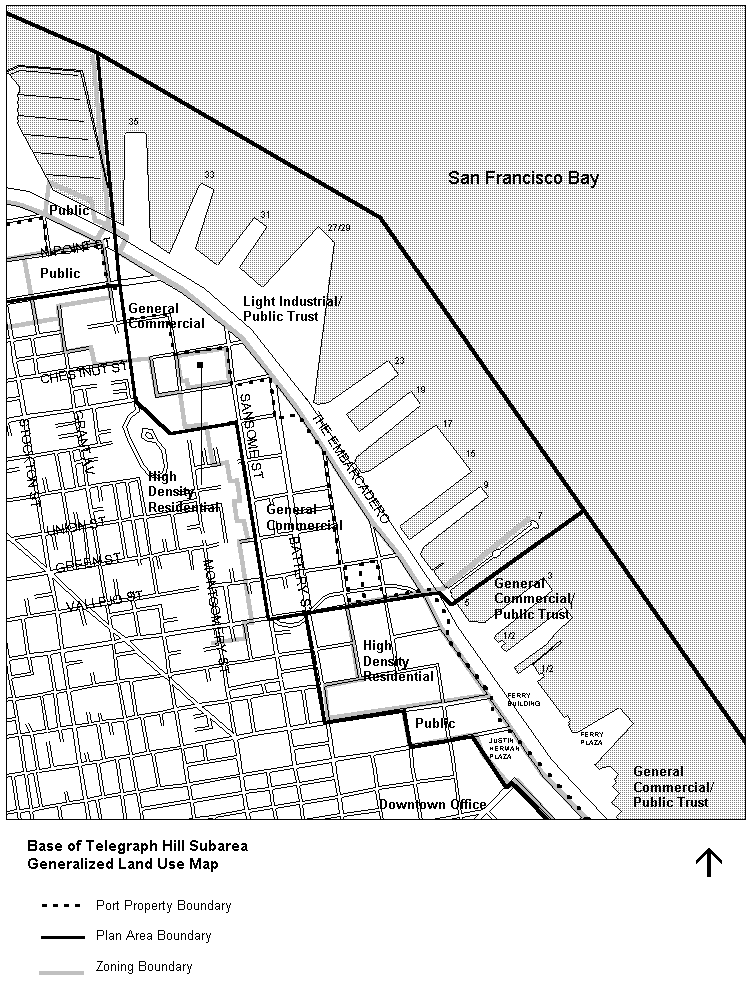
Base of Telegraph Hill Subarea
(Piers 35 through 7)
This subarea contains a mix of uses that reflect the area's maritime history and its transformation into a vital urban residential and commercial district. Cruise Terminal and maritime operations occupy some of the finger piers. Most of the inland properties have been redeveloped with offices for the design and communications industries, retail and residential uses, many of which occupy preserved and rehabilitated historic warehouses. The Pier 7 public open space and fishing pier, Cruise Terminal Plaza at Pier 27 James R. Herman Cruise Terminal, and Levi’s Plaza provide major recreational amenities in the subarea. Plan policies encourage the expansion of commercial and recreational maritime activities (e.g. ferries, water taxis, excursions, recreational boating) as part of major new mixed use developments on piers which provide daytime and nighttime commercial recreation venues and new public access improvements.
On inland sites, a variety of land uses are appropriate, including hotel, residential, office and other commercial activities. These new developments will be designed to preserve and enhance the rich historic character of the subarea and, as appropriate, highlight access points to the nearby North Beach, Chinatown and Fisherman's Wharf districts.
OBJECTIVE 16
TO RETAIN AND PROMOTE HARBOR SERVICE OPERATIONS, MARITIME, AND WATER-DEPENDENT ACTIVITIES.
POLICY 16.1
Continue to encourage maritime use on Piers 35 through 9.
POLICY 16.2
Promote maritime and water dependent activities (e.g. a cruise terminal, excursion boats, historic ships, recreational boat mooring, human-powered water recreation uses) which may be complemented with water-oriented commercial recreation and public assembly uses and public access improvements on piers no longer needed or suitable for cargo shipping facilities.
POLICY 16.3
Improve existing Pier 35 cruise facilities. If feasible, renovate the facility to provide a modern, functional passenger terminal with associated commercial recreation and public assembly uses. Maintain operation of the modern cruise terminal at Piers 27–29 and the adjacent public open space. Continue to evaluate alternative locations for the creation of another cruise berth.
OBJECTIVE 17
TO PRESERVE THE HISTORIC MARITIME CHARACTER OF THE AREA.
POLICY 17.1
Retain architecturally interesting and historically significant buildings or buildings which contribute substantially to the overall architectural character of the area. In particular, every effort should be made to preserve the Italian Swiss Colony Building, the Pelican Paper Company Warehouse, the Trinidad Bean and Elevator Company Warehouse, and the Beltline Roundhouse. Historic bulkheads, piers, and structures within the Embarcadero National Register Historic District should be retained and rehabilitated consistent with the U.S. Secretary of Interior Standards for the Treatment of Historic Properties, consistent with the Port of San Francisco's Waterfront Plan.
POLICY 17.2
Ensure the compatibility of new development with the historic and architectural maritime character of the Northeast Waterfront Historic District and Embarcadero Historic District in terms of scale, materials and design.
OBJECTIVE 18
TO DEVELOP A DIVERSITY OF ADDITIONAL ACTIVITIES WHICH WOULD STRENGTHEN THE EXISTING PREDOMINANT USES IN THE BASE OF TELEGRAPH HILL SUBAREA AND ACTIVITIES WHICH WOULD EXPAND THE PERIOD OF USE, BUT OF AN INTENSITY WHICH WOULD PROVIDE A RELIEF FROM THE ADJACENT DOWNTOWN AND FISHERMAN'S WHARF AREAS.
POLICY 18.1
Consistent with policies 18.2 and 18.3 encourage development of uses on inland sites which would strengthen the area's predominant uses of professional and general offices and design-related activities.
POLICY 18.2
Encourage the development of residential uses as a major use on inland sites in this area. Such use should be especially encouraged immediately adjacent to Telegraph Hill and at the upper levels of commercial development.
POLICY 18.3
Encourage moderate development of uses such as shops, restaurants, entertainment and hotels which activate the waterfront during evenings and weekends, but to a lesser overall intensity and concentration than present in the adjacent downtown and Fisherman's Wharf areas.
POLICY 18.4
Design new development on undeveloped seawall lots as an orientation point and transition from the waterfront to the Chinatown, North Beach, Barbary Coast, and Telegraph Hill neighborhoods.
POLICY 18.5
Plan and design new developments on inland sites and adjacent piers in a manner which complements and enhances the surrounding area, and which unites the waterfront with the rest of the City.
POLICY 18.6
Minimize the intensity of automobile activity by promoting mass transit and other non-vehicular modes of transportation through the implementation of transportation management plans and other means. Maximize efficient use of existing parking facilities in order to limit the amount of new parking necessary as part of new development.
POLICY 18.7
Encourage the provision of landscaping and publicly accessible open space in new development in the Base of Telegraph Hill area.
POLICY 18.8
Maintain permanent public open space on Pier 7. Allow limited improvements such as convenience food and beverage sales from pushcart vendors, which increase active use and enjoyment of the open space, and nearby public information kiosks and public restrooms, provided that they maintain an uncluttered appearance in the area. Take advantage of views of Pier 7 from new development on adjacent piers or inland sites to Pier 7 and maintain city views from Pier 7.
OBJECTIVE 19
TO DEVELOP A BALANCED TRANSPORTATION SYSTEM WHICH ACCOMMODATES REGIONAL AND LOCAL MOVEMENT WHILE CAUSING MINIMUM ADVERSE IMPACT TO THE ENVIRONMENT.
POLICY 19.1
Discourage through traffic except in those limited areas designated for this movement.
POLICY 19.2
Design transportation access to new developments on seawall lots to minimize congestion on Bay Street, Broadway and The Embarcadero.
POLICY 19.3
Encourage a portion of the surface regional transit to use inland routes to the downtown to minimize the impact on the waterfront.
OBJECTIVE 20
TO DEVELOP THE AREA IN SUCH A WAY AS TO PRESERVE AND ENHANCE THE PHYSICAL FORM OF THE WATERFRONT AND TELEGRAPH HILL, AND TO PRESERVE VIEWS FROM THE HILL.
POLICY 20.1
Maintain low structures near the water, with an increase in vertical development towards Telegraph Hill.
POLICY 20.2
Avoid the blockage of private and public views and maintain sight lines between the waterfront and Telegraph Hill.
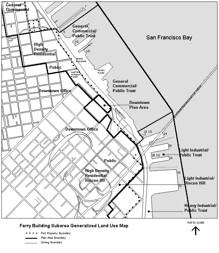
Ferry Building Subarea
(Piers 5 through north of Pier 22)
Previous iterations of this Plan included policies to rehabilitate the historic Ferry Building, a city and national landmark structure which stands as the centerpiece of the Northeastern Waterfront. Other earlier policies called for creating open water between the Agriculture Building and Pier 22 and converting a portion of The Embarcadero into the creation of Rincon Park, an iconic urban open space and restaurants area. These improvements were planned as an integral part of transforming The Embarcadero into an urban boulevard following the removal of the Embarcadero Freeway. These were the City’s first investments to establish a public realm along the waterfront as a relief to the intensely developed downtown, which preserved the continued prominence of the Ferry Building and its tower. The Ferry Building has been rehabilitated consistent with the Secretary of the Interior's Standards for Rehabilitation, along with development of the Downtown Ferry Terminal to re-establish this area as a major regional transit center at the eastern terminus of Market Street. It provides a major entryway to the City from the water, with increased ferry, excursion boat and water taxi service, and other modes of water transport, and a place to moor historic ships and pleasure boats. Inside, the Ferry Building provides public spaces to support transit functions along with complementary public market, food and beverage activities, offices, and cultural activities that foster public enjoyment of the waterfront. The waterside features are linked by a simple, elegant promenade which runs along the entire length of The Embarcadero, creating a visual corridor along the water's edge that complements a variety of water edge experiences. The centerpiece of this promenade will be a grand new plaza on the bay side of the Ferry Building. The subarea includes the Golden Gateway development north of the Ferry Building which was successfully redeveloped into an urban residential mixed use neighborhood, including Sidney Walton Park.
South of the Ferry Building, the historic Agriculture Building will be preserved. Rincon Park has been created, a major water-related soft surface public park with a 'Tavern-on-the-Green' type of restaurant, south of Folsom Street.
OBJECTIVE 21
TO MAINTAIN AND PROMOTE A MAJOR RESOURCE OF OPEN SPACE AND PUBLIC ACCESS CONNECTIONS PROVIDING MAXIMUM ACCESS TO AND ALONG THE WATERFRONT FOR THE LARGE NUMBER OF PEOPLE WHO LIVE IN, WORK IN AND USE THE ADJACENT DOWNTOWN AREA, PROVIDING RELIEF FROM THE INTENSELY DEVELOPED DOWNTOWN.
OBJECTIVE 22
TO DEVELOP A MIXTURE OF USES WHICH WILL PROVIDE A TRANSITION BETWEEN THE INTENSE CONCENTRATION OF OFFICE ACTIVITY IN THE DOWNTOWN AREA AND THE RECREATION ACTIVITIES OF THE WATERFRONT, WHICH WILL GENERATE ACTIVITY DURING EVENINGS AND WEEKENDS TO COMPLEMENT THE WEEKDAY OFFICE USES IN THE ADJACENT DOWNTOWN AREA.
OBJECTIVE 23
TO ALLOW COMMERCIAL AND RECREATIONAL MARITIME USES, PUBLIC ACCESS IMPROVEMENTS AND NON-MARITIME COMMERCIAL RECREATION DEVELOPMENT ON PIERS AND ALONG THE SEAWALL TO GENERATE WATERFRONT ACTIVITY, TO PROVIDE VISUAL AND ACCESS IMPROVEMENTS AND TO PRODUCE REVENUE FOR THE PORT.
OBJECTIVE 24
TO RESTORE AND REHABILITATE THE FERRY BUILDING AND AGRICULTURE BUILDING IN A MANNER CONSISTENT WITH THE SECRETARY OF INTERIOR STANDARDS TO PRESERVE THE HISTORIC MARITIME CHARACTER OF THE AREA.
OBJECTIVE 25
TO MAXIMIZE VIEWS OF THE WATER AND OF WATERFRONT ACTIVITY.
OBJECTIVE 26
TO FURTHER DEVELOP THE FERRY BUILDING AND DOWNTOWN FERRY TERMINAL AREA AS A MAJOR TRANSIT CENTER, IMPROVING AND EXPANDING TRANSIT ACCESS BY, AND TRANSFERS AMONG, LANDSIDE AND WATERSIDE TRANSIT SYSTEMS.
Golden Gateway (Blocks 167-171, 198-201)
POLICY 26.1
Maintain the Golden Gateway residential community and neighborhood-serving retail uses.
POLICY 26.2
Maintain the Sidney Walton Park as an urban park serving downtown workers and residents.
POLICY 26.3
Provide views of the water from the Embarcadero through or alongside the building and use the central archway for access to major bulkhead uses.
POLICY 26.4
Provide cultural, assembly and entertainment, and other commercial recreation activities on Pier 3 which provide activities/attractions for downtown residents, workers and visitors, and take advantage of expanded public transportation services available in the Ferry Building Subarea.
POLICY 26.5
Include public access improvements in major new development on the pier, furthering the creation of a PortWalk which will connect with the existing and future open space network and pedestrian promenade along The Embarcadero.
POLICY 26.6
Preserve and rehabilitate the historic bulkhead structures, allowing for the enhancement or creation of waterfront or Bay views through existing openings or new openings which do not adversely affect the building's historic architectural character. Permit construction of a pier shed that extends from the Pier 3 bulkhead building onto the pier if consistent with Secretary of Interior Standards for Treatment of Historic Properties, and provide a pedestrian walkway around the shed and building.
POLICY 26.7
Promote new maritime attractions and waterside access, such as water taxi and excursion boat stops, historic ships and temporary mooring areas as part of new development.
Pier 1 - 1/2
POLICY 26.8
Preserve and rehabilitate the bulkhead building for museum, commercial recreation and public assembly, community facilities, artist/designer studios and galleries and/or office uses.
Pier 1
POLICY 26.9
Preserve and rehabilitate the bulkhead and pier building as headquarter location for the Port of San Francisco. Provide continuous peripheral public access around the water sides of the pier, unless limited by public safety considerations or maritime operational needs.
POLICY 26.10
Permit ground floor retail uses, and public meeting space in Port offices, at Pier 1 to support community engagement and space for public events and activities, which complement activities in the downtown and take advantage of transportation improvements planned for the Ferry Building Subarea. Encourage maritime activities, and provide for vessel berthing, operations and emergency response capabilities.
Promenade/PortWalk
POLICY 26.11
Improve Herb Caen Way/The Embarcadero Promenade and PortWalk from Pier 5 to Pier 22-1/2 south of the Agriculture Building. Design the promenade to be a simple, elegant statement of movement along the water's edge which maintains visual continuity and creates a variety of water-edge experiences. Provide appropriate street furniture including wind protected seating areas and pedestrian scale lighting.
POLICY 26.12
Develop public access improvements on Piers 3 and 1 which contribute to creation of the PortWalk, integrating open spaces and public access into major new development on piers and connecting with Herb Caen Way/The Embarcadero Promenade.
POLICY 26.13
Maintain and enhance public use and enjoyment of the rehabilitated Ferry Building. Ensure that any future changes and construction at the Ferry Building follow the requirements of the Secretary of Interior’s Standards for Rehabilitation.
POLICY 26.14
Maintain the rehabilitated Ferry Building as a civic gathering place that includes ground floor shops and restaurants, public spaces (e.g. exhibit, civic displays, passenger waiting areas, community facilities) and transportation services on the ground floor, and office, commercial recreation and/or public assembly activities on the second and third floors.
POLICY 26.15
Maintain the plaza in front of the Ferry Building as a grand civic plaza, which creates a forecourt for the Ferry Building and a symbolic terminus to Market Street.
POLICY 26.16
Continue to support and promote the Downtown Ferry Terminal at the Ferry Building as a primary destination point for all ferry and excursion boat riders on San Francisco Bay. The Downtown Ferry Terminal should continue to provide a range of public landing facilities accessible to the disabled community to accommodate all vessel types requiring access to San Francisco. Any landing facilities should allow multiple operators access to the facilities.
POLICY 26.17
Ensure ongoing pedestrian access through the Ferry Building to the Downtown Ferry Terminal and the Golden Gate Ferry Terminal. Maintain a continuous walkway along the eastern side of the Ferry Building that is separate from service vehicle access, to improve public access and to provide expanded space for ferry, excursion boat, water taxi and other waterborne transit riders.
POLICY 26.18
Improve the Ferry Plaza, immediately east of the Ferry Building to create a civic outdoor gathering space for farmers markets and events, allowing minor amounts of outdoor commercial recreation uses which are consistent with the open space use of the Plaza and a regional ferry transportation center (e.g. a cafe, outdoor dining, flower vendors and other convenience retail services for commuters and visitors). Design Ferry Plaza improvements to integrate and enhance surrounding the Ferry Building, Golden Gate and Downtown Ferry Terminals, and restaurant uses and operational requirements, including access and maintenance of BART infrastructure facilities located on the pier.
POLICY 26.19
Rehabilitate and adaptively reuse the Agriculture Building, consistent with the Secretary of the Interior's Standards for Rehabilitation, for the following types of potential activities: museum, community facilities, commercial recreation and public assembly, artist/designer studios and galleries, and general office. Design improvements that integrate with and enhance the Downtown Ferry Terminal and Plaza, and improve the public realm along The Embarcadero Promenade.
POLICY 26.20
Maintain and enhance the portion of Herb Caen Way/The Embarcadero Promenade between the Agriculture Building and the Pier 22-1/2 Fireboat House. Maintain visual continuity along the water and create a variety of water edge experiences.
POLICY 26.21
Maintain open water between Pier 14 Public Access and Pier 22-1/2 Fireboat House as a visual relief to the intensely developed Downtown.
Rincon Park
POLICY 26.22
Maintain Rincon Park in the strip vacated by the Embarcadero and on Blocks 3742 and 3743, adjacent to and inland of the Herb Caen Way/Embarcadero Promenade. Orient the park to the Bay and relate the park to the recreational preferences of residents and workers in the City and Bay Area, rather than tourists. Maintain the restaurants within Rincon Park that provide opportunities for indoor and outdoor dining and special events, and extend seasonal and nighttime activities that complement and enhance public use of the park.
POLICY 26.23
Change the Height and Bulk District on Block 3743 from 84-E to 40-X. Change the Height and Bulk District on the rest of the Rincon Park Site to open space.
South Beach Subarea
(Piers 22-1/2 through 46 B)
The South Beach Subarea extends from the Pier 22-1/2 Fireboat House, adjacent to Rincon Park, to China Basin Channel and inland for a depth of one or two blocks. Since the 1980's, this subarea has been transforming into a new residential and commercial mixed use neighborhood, which still retains some of its industrial and maritime past. Because the piers originally built for breakbulk shipping are now obsolete, they no longer serve a primary maritime function. Piers 24, 34, and 36 became deteriorated and were removed, increasing the expanse of Bay waters and making way for construction of the Brannan Street Wharf public plaza. South Beach Harbor, a full-service marina and small boat harbor, was completed in 1986 adjacent to Pier 40, which entailed the removal of former Piers 42-46A. In 2000, the San Francisco Giants completed development of a new ballpark along the north side of China Basin Channel, which attracts many visitors to the waterfront. The ballpark, South Beach Harbor, and waterfront parks, together with the transportation improvements installed along the Embarcadero, provide key waterfront amenities and a connected open space network for the public and residents in the new inland Rincon Hill and South Beach neighborhoods. The South Beach Harbor, together with the transportation improvements installed along The Embarcadero, provide key waterfront amenities, including boating and water recreation, for residents in the new inland Rincon Hill and South Beach neighborhoods.
Plan policies encourage redevelopment on other piers to provide opportunities for improved excursion boat, ferry and historic ship berthing and other maritime facilities, maritime support operations, and public oriented uses to provide a variety of activities to attract public use and enjoyment of the waterfront. Public access improvements also are proposed which will make the waterfront inviting and safe for nearby residents as well as visitors from downtown and beyond. The remaining inland sites which are vacant or underutilized may be developed with residential or commercial uses which complement the redeveloped areas in South Beach and Rincon Hill and new pierside activities, as well as accommodate accessory parking associated with new uses in the vicinity.
On non-Port owned inland areas, a mixed-income residential community with open spaces and other residential-serving uses have been developed on previously vacant or underutilized property, including the adaptive reuse development of the Oriental Warehouse as live/work studios. Walkways and bicycle paths combined with small plazas connect the new residences to waterfront activities and other portions of the City. The new community is characterized by high density, low to mid-rise structures, recreating the fine-grained fabric of San Francisco neighborhoods and takes advantage of proximity to the Downtown, a desirable microclimate, amenity value of the Bay, and helps meet San Francisco's need for new housing. Originally a part of the South Beach Redevelopment Project Area, much of this area has now been incorporated into the East SoMa Area Plan, a part of the Eastern Neighborhoods.
OBJECTIVE 27
TO ENHANCE THE ECONOMIC VITALITY OF THE AREA AND CAPITALIZE ON ITS UNIQUE LOCATION AND ENVIRONMENTAL ATTRIBUTES FOR COMMERCIAL AND RECREATIONAL MARITIME ACTIVITIES, MARITIME SUPPORT USES, COMMERCIAL AND RECREATIONAL USES, AND RESIDENTIAL DEVELOPMENT AND NEIGHBORHOOD SERVICES.
OBJECTIVE 28
WORK WITH RESIDENTS IN SOUTH BEACH AND ADJACENT NEIGHBORHOODS TO MAKE THE WATERFRONT INVITING AND SAFE BY PROVIDING WATER-ORIENTED COMMERCIAL RECREATION AND PUBLIC ASSEMBLY ACTIVITIES ON PIERS WHICH APPEAL TO RESIDENTS, WORKERS AND VISITORS OF THE CITY.
OBJECTIVE 29
TO PROMOTE A CONTINUOUS SYSTEM OF OPEN SPACES THROUGHOUT THE SUBAREA BY CREATING PUBLIC ACCESS IMPROVEMENTS AS PART OF MAJOR NEW PIERSIDE DEVELOPMENTS, WHICH CONNECT WITH AND EXPAND UPON THE NETWORK OF LANDSCAPED AREAS AND PUBLIC PARKS ALREADY DEVELOPED OR UNDERWAY.
OBJECTIVE 30
TO MAINTAIN HIGH STANDARDS IN THE DESIGN OF NEW DEVELOPMENT WHICH GIVE RISE TO A NEW ARCHITECTURAL IDENTITY FOR THE SHORELINE, AND WHICH COMPLEMENTS INLAND DEVELOPMENT.
Pier 22-1/2
POLICY 30.1
Preserve and restore the historic Fireboat House at Pier 22-1/2 and construct a new fireboat station facility that supports modern fire and emergency services, equipment, and operations.
POLICY 30.2
Design new development which takes advantage of sweeping views of the downtown, and which preserves and enhances views of the Bay Bridge and water from Harrison Street.
POLICY 30.3
Allow the development at Pier 26 and 28 of commercial recreation, some community facility, artist and designers studios and galleries, public assembly and/or maritime uses, but exclude, hotel and boatel uses. Permit such uses in the existing sheds or new replacement structures, and incorporate new public access areas onto the piers which connect with and complement The Embarcadero Promenade and adjacent planned Rincon Park. Orient this development towards Bay Area residents and workers rather than tourists. Ensure development maintains the integrity of the Embarcadero Historic District’s nationally recognized historic maritime structures.
Pier 30-32
POLICY 30.4
Promote new development on Pier 30-32 which provides commercial recreation and public assembly activities, and maritime operations such as an excursion boat or cruise terminal. New development should provide a multi-faceted mix of activities oriented around a common theme rather than a singular commercial attraction. Allow accessory parking on the pier to serve these activities.
POLICY 30.5
Include public access improvements – including water recreation activities in the Bay – as a key component of major new development on the pier to further the creation of a PortWalk which guides circulation on the pier, takes maximum advantage of views of the City and the water, and which connects to the pedestrian improvements along The Embarcadero.
POLICY 30.6
Encourage activities that do not generate peak traffic volumes during commute periods in order to minimize congestion on roadway and transit systems.
POLICY 30.7
Require a high standard of architectural design appropriate to the prominence of the site, which also establishes a new architectural identity and standard for waterside development in the South Beach area.
POLICY 30.8
Develop uses which support and enhance the mix of maritime and commercial recreation uses developed on Pier 30-32, as well as provide a transition between residential uses on inland blocks and public-oriented activities on the waterfront. Block 3771 would be a desirable location for a mixed commercial and residential development or a hotel, depending on the combination of uses developed on Pier 30-32. Development design should complement the neighborhood setting and contribute to the public realm on the west side of The Embarcadero. Incorporate off-street parking into the development program for Block 3771 to serve a significant amount of the parking demand associated with the Pier 30-32 development, if necessary.
Piers 30 - 40, and South Beach Harbor
POLICY 30.9
Continue to ensure public access to the Brannan Street Wharf open space and the expansive views of the water that it enables that was created by the removal of Piers 34 and 36.
POLICY 30.10
Maintain South Beach Harbor as a small boat marina of approximately 700 slips for public pleasure craft and the public access and fishing pier on top of the breakwater.
POLICY 30.11
On Pier 40, provide a full range of services for recreational boating and water uses, including boat building and repair facilities, day dock storage, sail maker, boat sales and rental, ship chandlery and other uses related to the marina.
POLICY 30.12
Design any new or rehabilitated buildings on Pier 40 to reflect the bold, simple lines of traditional pier sheds. Ensure the integrity of the Embarcadero Historic District through historic preservation of the pier, while providing diverse maritime and public-oriented uses. Provide continuous peripheral public access along the water sides of the pier including sitting and fishing areas, except for portions of the pier which may remain in maritime-related activities, where such public access might conflict. Locate a prominent sitting area at the eastern end of the pier. Ensure that pier railings and other design elements be compatible with the promenade and breakwater design.
POLICY 30.13
Preserve the Pier 38 bulkhead building consistent with standards of the Embarcadero Historic District, and promote uses in the bulkhead and on the pier which support and enhance the recreational boating and water uses located at Pier 40, including accessory parking and commercial recreation amenities. Pier 38 offers an opportunity to expand recreational boating facilities and services in the future, if feasible, and a location for maritime support services.
South Beach Park
POLICY 30.14
Continue to support and potentially improve South Beach Park, between King and Second Streets and the Seawall, predominantly as a soft-surface park for public recreational use.
POLICY 30.15
South Beach Park has been developed to include areas for active sports such as volleyball and separate areas for passive activities such as sitting, game tables under shelter, and a tot lot. Include toilet and drinking facilities. The park has been designed to buffer the park from the Embarcadero with landscaping, berms, and changes in elevation. The park provides for drop-off parking to serve the South Beach Harbor marina and water recreation community. The design of the park maintains a hard-surface pedestrian promenade along the water's edge with opportunities for sitting and viewing. It connects the promenade to the peripheral public access areas on Pier 40 and to the South Beach Harbor breakwater, and continues the promenade to Third Street and Lefty O'Doul Bridge. Permit pedestrian access to the marina only from the pier and breakwater and not directly from the park. The park and harbor design include a location of boat dock for water taxies and transient boat stops. Operations of the park should allow a limited amount of commercial recreation use incidental to and supportive of the open space. Maintain the complementary designs of South Beach Park and the Harbormaster and community facility, and connect public access to the Giants' ballpark along China Basin/Mission Creek.
Residential Neighborhood
POLICY 30.16
Promote new development on Pier 30-32 which provides commercial recreation and public assembly activities, and maritime operations such as an excursion boat or cruise terminal. New development should provide a destination to complement the character and integrity of the Embarcadero Historic District and preserve the valuable deep-water berth at this location.
Pier 46B
POLICY 30.17
Continue to support and promote the Giants' ballpark and its accessory uses and activities, which include but are not limited to, office, retail, restaurants, live music performances and other forms of live entertainment, in a setting of waterfront public spaces.
POLICY 30.18
Maintain waterside public access improvements alongside the ballpark which connect with the South Beach Harbor and South Beach Park and provide a link to the Lefty O'Doul Bridge, thereby extending public access over China Basin Channel to the Blue Greenway open space network in Mission Bay.
Embarcadero Corridor
The removal of the Embarcadero Freeway and construction of the Waterfront Transportation Projects has dramatically changed the character of the Embarcadero Corridor. Policies for The Embarcadero are intended to continue to facilitate the movement of people and goods, maintain environmental quality, enhance physical and visual access to the shoreline and contribute to the continued vitality of the waterfront. Much of this has been achieved by the reconstruction of the roadway as a major waterfront boulevard, with public transit, bicycle, pedestrian promenade, sidewalk and landscaping improvements, and a public art program.
OBJECTIVE 31
TO IMPROVE THE EMBARCADERO CORRIDOR IN ORDER TO FACILITATE THE MOVEMENT OF PEOPLE AND GOODS, AND ENHANCE PUBLIC ACCESS TO AND ALONG THE WATER.
POLICY 31.1
Realign the Embarcadero roadway between Broadway and Berry Street as follows:
a. Widen the sidewalks in front of Ferry Building and create a major plaza in the roadway median as an appropriate terminus to Market Street;
b. Reroute the roadway inland to Steuart Street from Howard to Harrison Streets to reduce its impact on the waterfront and to create opportunities for water-related activities; close Steuart Street between Mission and Howard to through traffic.
c. Divert roadway traffic from Berry to King Streets to create opportunities for future water-related uses and to provide a direct transit link to the CalTrain Station.
POLICY 31.2
Maintain and improve the Embarcadero Roadway as follows:
a. Provide two lanes each for southbound and northbound traffic with right and left turn channelization at selected intersections;
b. Include an exclusive right-of-way for transit within the public right-of-way;
c. Provide a promenade for pedestrians and joggers along the water side of the roadway and a bikeway for cyclists on the roadway;
d. Provide signalized pedestrian crossings, integrated with transit stops along the Embarcadero at Bay, Sansome, Filbert, Green, Broadway, Washington, Market, Folsom, and Brannan Streets and on King Boulevard at Second and Fourth Streets. Establish traffic signals and speed limits which give priority to pedestrian movement across the Embarcadero roadway; and
e. Light the roadway with ornamental fixtures similar to those presently found along the Embarcadero. Lighting levels should be sufficient for public safety while avoiding unnecessary glare. Plant street trees with an irrigation system along the right-of-way, transit way and promenade in a way that protects the urban, maritime character of the waterfront and preserves the views of the bay.
Transit
POLICY 31.3
Provide rail transit service in an exclusive transit way from Fort Mason to the Southern Pacific Depot. An extension of Market Street surface rail, the F-Line should operate north of Market Street; the vehicles should be historic in character in order to provide a special waterfront transit identity. South of Market Street the transit service should be a surface extension of the MUNI Metro. Allow for continuous rail transit service along the length of the waterfront.
POLICY 31.4
Provide a MUNI Metro storage and maintenance facility in the Third Street Corridor.
POLICY 31.5
Provide transit stops at Bay, Sansome, Filbert, Green, Broadway, Washington, Market, Folsom, Brannan, Second and Fourth Streets.
POLICY 31.6
If found to be feasible after further analysis, extend certain trolley and bus lines and the California Street Cable Car to the Ferry Building. Facilitate pedestrian movement from Justin Herman Plaza to the Ferry Building.
POLICY 31.7
Prohibit heliports or STOL ports, but continue to allow for emergency landings.
Resilience
OBJECTIVE 32
ENSURE LAND USE AND DEVELOPMENT DECISION MAKING INCORPORATES THE NEED TO ADDRESS RESILIENCY FROM POSSIBLE FUTURE HAZARDS, PARTICULARLY FUTURE FLOODING CAUSED BY SEA LEVEL RISE AND CLIMATE CHANGE.
POLICY 32.1
Engage the community in planning for the potential impacts of Sea Level Rise and other potential hazards on an ongoing basis.
POLICY 32.2
Ensure that members of the vulnerable communities previously left out of Waterfront-related planning are engaged in planning for Sea Level Rise and other potential hazards.
POLICY 32.3
Ensure that recreational users of the waterfront, including swimmers, rowers, kayakers, and human powered vessel users, are engaged in planning for Sea Level Rise and other potential hazards.
OBJECTIVE 33
PROTECT AND ENHANCE THE EXISTING WATERFRONT, CRITICAL PORT AND CITY UTILITIES AND INFRASTRUCTURE, AND COMMUNITY, HISTORIC, AND ECONOMIC ASSETS FOR AS LONG AS POSSIBLE; INCORPORATE ADAPTION CHANGES IN LINE WITh OVERALL CITY RESILIENCE AND ADAPTION PRINCIPLES AND STRATEGIES.
POLICY 32.1
Encourage and design resilience projects that achieve multiple Waterfront Plan urban design, historic preservation, recreation, public access and open space, transportation, maritime and environmental goals and benefits.
The Port and the City have engaged the local community, planners, engineers, and other stake holders in planning for future flood and other risks through the Waterfront Resilience Program. The Resilience Program looks to implement adaptation strategies that protect public and private assets and the community at large, while anticipating a changing climate. Such efforts should be ongoing, but flexible as environmental conditions of the Northeastern Waterfront change over time.
Glossary of Terms
Bay-Oriented (or Water-Oriented) Commercial Recreation and Bay-Oriented Public Assembly: Non-maritime facilities specifically designed to attract large numbers of people to enjoy the Bay and its shoreline, such as restaurants, cafes, specialty shops, hotels, boatels, theaters, concert halls, galleries, amusements, night clubs, cabarets, and the ballpark at Pier 46B. On Port property, hotels are restricted to sites which are located more than 100 feet inland from the shoreline.
Burton Act: State legislation which sets the terms and conditions for the transfer of Port property to the jurisdiction of the City and County of San Francisco, subject to control and management by a local Port Commission. (California Statutes, Chapter 1333, 1968.)
Cargo Shipping: Primary, support and ancillary facilities for waterborne transport of cargo including but not limited to: shipping terminals and berths, cargo handling, storage and warehousing, equipment storage and repair facilities, cargo sourcing, container freight stations, freight rail and truck access, ship servicing, administrative functions, and employee support services, (e.g. training facilities, parking).
Commercial and Recreation Maritime Activities (See also definition of 'Maritime'): Waterborne activities providing waterfront attractions which enhance public enjoyment of the water including but not limited to ferries and excursion boats, cruise terminal, historic ships, and recreational boating.
Fill: As defined in the McAteer-Petris Act, "earth or any other substance or material including pilings or structures placed on pilings, and structures floating at some or all times and moored for extended periods, such as houseboats and floating docks."
Maritime: A general term used to describe industrial, commercial or recreation activities related to the conduct of waterborne commerce navigation and recreation, including but not limited to: cargo shipping, ship repair, ferries and excursion boats, cruises, recreational boating, historic ships, fishing industry and berthing.
Maritime Support Services: Ancillary functions needed to support maritime activities including but not limited to: tug and tow operations, bar pilots, ship chandlers, associated parking and maintenance, equipment storage, repair and warehouse facilities, environmental services, Foreign Trade Zone and Port maintenance.
McAteer-Petris Act: An Act passed by the State legislature in 1969 which created the San Francisco Bay Conservation and Development Commission (BCDC).
PortWalk: New public access walkways and amenities extending onto piers, where feasible, as major new mixed use pier developments occur that, together with public sidewalks and rights-of-way and pedestrian improvements under construction along The Embarcadero, will provide continuous pedestrian access through waterfront activity areas. PortWalk improvements will primarily be located north of China Basin, but also could be established south of China Basin where possible.
Public Trust: Under the public trust doctrine, title to tidelands and lands under navigable waters (as existed when California became a state) is held in trust by the State for the benefit of the people of California and must be used for purposes of commerce, navigation and fishing as well as for environmental and recreational purposes. The Port of San Francisco is the trustee for public trust lands granted to the City by State legislation in 1968 (i.e. the Burton Act).
Amendment by Planning Commission Resolution 11882 adopted on 2/21/1990
Amendment by Planning Commission Resolution 13159 adopted on 8/22/1991
Amendment by Planning Commission Resolution 13907 adopted on 7/6/1995
Amendment by Planning Commission Resolution 14194 adopted on 9/19/1996
Amendment by Planning Commission Resolution 14240 adopted on 11/21/1996
Amendment by Planning Commission Resolution 14324 adopted on 3/6/1997
Amendment by Planning Commission Resolution 14400 adopted on 6/26/1997 and Board of Supervisors ordinance 277-97 adopted on 7/8/1997
Amendments by Planning Commission Resolution 14414 adopted on 7/10/1997 and Board of Supervisors Ordinance 760-97 adopted on 8/11/1997
Amendment by Planning Commission Resolution 14467 adopted on 10/16/1997 and Board of Supervisors Ordinance 26-98 on 1/5/1998
Amendment by Planning Commission Resolution16626 adopted on 07/31/2003
Amendments by Board of Supervisors Ordinance 0251-03 adopted on 10/21/2003
Amendments by Board of Supervisors Ordinance 0105-12 adopted on 06/19/2012
Amendments by Board of Supervisors Ordinance 0155-23 adopted on 07/25/2023.