East SoMa (South of Market) Area Plan
NOTE: Planning efforts in the larger South of Market area have been taking place in a number of sub-areas. These include the Rincon Hill Plan, adopted in 2005, the Transbay Redevelopment Plan, adopted in 2004, and the Western SoMa Plan, currently ongoing, as well as this East SoMa Area Plan.
INTRODUCTION
Since the turn of the twentieth century, the South of Market Area has boasted an eclectic mix of commerce, entertainment and living space. SoMa has always been a uniquely mixed-use area in San Francisco. Early zoning regulations in San Francisco pushed much of the city’s industrial activity south of Market Street. In response, worker housing was built for factory and warehouse workers close to their places of employment, as well as for merchant marines, sailors, and others associated with San Francisco’s extensive waterfront activity. New immigrants to the city were drawn to low rents typical of SoMa throughout the century and the proximity to jobs. Successive waves of ethnic groups have called SoMa home. When various immigrant groups such as the Germans, Mexicans, Ukrainians, and Irish have moved out of the area, their churches and community centers have remained and preserved their relationship to this area.
Although people have lived in SoMa since its beginnings, the area is known for its industry. The garment industry as well as printing and publishing and auto repair have long been a presence in SoMa. These businesses form “clusters,” where individual businesses and the economy as a whole benefit from their agglomeration. The design industry and the downtown office core have benefited from proximity to these clusters of businesses
SoMa has always experienced transition hand in hand with its diversity. Not only have the demographics of SoMa shifted over time, but whole neighborhoods have sprouted in places formerly devoid of residents. Change has come in the form of business activities, building types, business and residential tenants in these buildings, occupancy rates and the cost of leasing or buying space. In fact, that which does not change in SoMa often is considered an anomaly.
The tides of the economy dictate many of these changes. SoMa has clearly been affected by the economic roller coaster of the past several years. The Multimedia Gulch emerged in SoMa in the area surrounding South Park. Technically savvy entrepreneurs who sought cheap space near the downtown found converted warehouse space to rent, move into, and develop their business ideas. San Francisco and specifically South of Market became internationally recognized as a mecca for people with new ideas in the field of technology. Developers, aware of this influx of people with discretionary income, began to build live/work units, aware that industrial land in SoMa was the cheapest land in proximity to the Multimedia Gulch and that building on industrially zoned land was less restrictive in terms of building standards and planning requirements. Unlike other San Francisco neighborhoods, SoMa often had little community scrutiny of individual projects. As a result, live/ work projects were built in an ad-hoc manner throughout the area.
The mass production of live/work units was the first of two waves of real estate development that changed the landscape of SoMa. The second wave came in the form of new office space. Multimedia activities and computer animation brought people to San Francisco in the mid-1990s; eventually many of these newcomers migrated onto dot com businesses. As venture capitalists invested billions of dollars in internet start-up companies in the Bay Area, the impact on SoMa came in the form of large sums of money thrown into the commercial estate market. Developers redirected their focus to office. Internet start-ups sought spaces with flexible open floor plans and high ceilings.
On the flip side of all of this growth, the production, distribution and repair (PDR) businesses suffered. For the past half-century, the printing, publishing, and apparel industries have been the largest PDR sectors in SoMa. In 1998, over 100 SoMa businesses in the apparel- manufacturing and import/export trade sectors employed over 2,400 people. By 2001, the number of apparel sector businesses and employees in SoMa dropped to just under 800 people employed by about 40 businesses. While the number of apparel and printing jobs has diminished in the this area, other PDR industries have gained employees. In general, larger firms have survived and sometimes grown in the area, while some smaller firms may not have been able to compete for the limited and expensive space available.
In addition to the Eastern Neighborhoods-wide goals outlined above, the following community-driven goals were developed specifically for East SoMa, over the course of many public workshops:
- Encourage an appropriate mix of uses.
- Retain and promote businesses and organizations that contribute to the diversity of the neighborhood.
- Encourage more neighborhood-serving businesses.
- Attract jobs for local residents.
- Encourage a mix of incomes in renter- and owner-occupied housing.
- Increase affordable housing opportunities.
- Improve the character of streets and encourage pedestrian safety.
- Improve community facilities and enhance open spaces.
- Offer a variety of transportation options
1. Land Use
This section presents the vision for the use of land in East SoMa. It identifies activities that are important to protect, attract and encourage and establishes their pattern in the neighborhood. Since the turn of the century, East SoMa has been home to a mix of land uses, including commerce, entertainment and living space. Most of the buildings that exist now are small office or production, distribution and repair (PDR) spaces that line the major streets, while housing units are located in primarily two to four story buildings that line the small alleys of the residential enclave districts.
Recently, this area has seen a vast amount of change, especially in housing development. Additionally, “dot com” businesses moved into the area, many of which displaced existing jobs and residences. On occasion conflicts have arisen between some of these new office or residential uses and previously existing industrial uses, due to noise or other by-products of industrial businesses. This section addresses the need to retain space for existing businesses and residential uses, while allowing space for new development, especially affordable housing, to be built.
OBJECTIVE 1.1
ENCOURAGE PRODUCTION OF HOUSING AND OTHER MIXED-USE DEVELOPMENT IN EAST SOMA WHILE MAINTAINING ITS EXISTING SPECIAL MIXED-USE CHARACTER
The intent of this Plan is to keep East SoMa a place of mixed uses, where new affordable and market rate housing, offices and retail can mix with viable production, distribution or repair (PDR) businesses, and small institutions. PDR businesses will not be strongly protected through proposed new zoning in this area, because of its proximity to the city center. Nevertheless, it is expected that a good number of PDR establishments will remain viable into the future, adding to the unique mix in East SoMa. (See the Economic Development chapter of this Plan, which addresses business assistance and workforce development in this area.)
Zoning districts intended to promote mixed-used development were established for SoMa in 1990, including the Service Light Industrial (SLI), Service Light Industrial Residential (SLR), Residential Service District (RSD), the Service Secondary Office (SSO), Residential Enclave Districts (RED) and the South Park District (SPD). The districts varied based on the mix of residential development and light industrial businesses allowed or encouraged. Since the adoption of these districts, however, conditions have changed and much of the development originally envisioned has not occurred. But because much of the existing controls’ structure and the vision of retaining a mix of uses is still relevant, the new zoning districts proposed in this Plan generally cover the same geography as the existing controls, but with the following refinements:
Mixed Use Office (MU-O)
The existing “SSO” district, centered along the 2nd Street Corridor, is designed to accommodate light industrial businesses and professional office space. Dwelling units currently require a conditional use permit. To encourage more office and housing development here, new land use controls proposed in this Plan, designated as “Mixed Use Office,” will replace the existing SSO district and allow a mix of affordable and market-rate housing as-of-right as well as increasing the size of permitted offices.
Mixed Use General (MU-G)
The existing SLR district will be renamed as “Mixed Use – General,” but controls will remain largely unchanged. The original intent of this area was to permit housing and PDR uses to mix. This plan proposes to allow some small office in addition to encourage space for small start-up businesses.
Residential Enclave District (RED)
This is the only primarily residential district in SoMa. The RED district is a small-scale residential district centered around the alleys. The goal of this district is to preserve these small-scale residential uses. The controls for this district will remain the same. New alley guidelines will be added to preserve the sunlight and air to these alleys.
Downtown Residential (DTR)
The Rincon Point South Beach area still retains “Heavy Industrial” (M-2) zoning. The Redevelopment Plan here, which calls for medium to high density residential development, supersedes this zoning, though it still remains in the Planning Code. The area is currently built out as a residential neighborhood and so this Plan proposes to introduce Downtown Residential (DTR) Zoning in this district, requiring housing and encouraging supporting commercial and institutional uses.
6th Street Neighborhood Commercial Transit District
This new neighborhood commercial district is proposed along 6th Street. The intent of this district is to encourage more small-scale neighborhood-serving uses with housing encouraged above the ground floor.
The policies to address the objective outlined above are as follows:
POLICY 1.1.1
Make land use decisions considering the context of East SoMa at multiple geographic scales, including the immediate neighborhood, all of SoMa, the city, and the region.
POLICY 1.1.2
Encourage small flexible, office space throughout East SoMa and encourage larger office in the 2nd Street Corridor.
POLICY 1.1.3
Encourage housing development, especially affordable housing by allowing residential uses everywhere in the Plan Area and requiring substantial amounts of affordable housing.
POLICY 1.1.4
Retain the existing flexible zoning in the area zoned MUG, but also allow small offices.
POLICY 1.1.5
In the Rincon Point/South Beach Redevelopment area, acknowledge the relatively dense residential development that has already occurred.
POLICY 1.1.6
Retain East SoMa’s existing residential alleys for residential uses.
POLICY 1.1.7
Retain the existing small-scale uses and character around South Park.
POLICY 1.1.8
Permit small and moderate size retail establishments in mixed use areas of East SoMa, but permit larger retail only as part of a mixed-use development.
POLICY 1.1.9
Require active commercial uses and encourage a more neighborhood commercial character along 6th Street.
POLICY 1.1.10
While continuing to protect traditional PDR functions that need large, inexpensive spaces to operate, also recognize that the nature of PDR businesses is evolving gradually so that their production and distribution activities are becoming more integrated physically with their research, design and administrative functions.
OBJECTIVE 1.2
MAXIMIZE HOUSING DEVELOPMENT POTENTIAL IN KEEPING WITH NEIGHBORHOOD CHARACTER
It is important that new housing is developed in appropriate areas, that it is compatible with its surroundings, and that it satisfies community housing needs. Allowing additional housing in East SoMa’s mixed use and formerly industrial areas permits new development to capitalize on existing infrastructure. Mixed use controls will allow for compatible housing development in East SoMa, mixed with PDR, retail, and other uses. This will add to the vibrancy of the area, preserve its special character, and buffer residential enclaves from more intensive uses including the freeway. By increasing development potential on some parcels, reducing parking requirements, and replacing existing unit density controls with “bedroom mix” controls that require a portion of new units to be larger and more family-friendly, more housing of the appropriate type can be encouraged.
Strong building design controls, discussed further in the Built Form chapter of this Plan, should ensure that these new buildings are designed to be compatible with their surroundings. Building facades should be broken up, development above a certain height should be set back on small residential alleys to allow light and air, and active ground floors should be required.
The policies to address the objective outlined above are as follows:
POLICY 1.2.1
Encourage development of new housing throughout East SoMa.
POLICY 1.2.2
Ensure that in-fill housing development is compatible with its surroundings.
POLICY 1.2.3
For new construction, and as part of major expansion of existing buildings, encourage housing development over commercial.
POLICY 1.2.4
In general, where residential development is permitted, control residential density through building height and bulk guidelines and bedroom mix requirements.
POLICY 1.2.5
Identify areas of East Soma where it would be appropriate to increase maximum heights for residential development and correspondingly increase public benefits contributions required of developers.
OBJECTIVE 1.3
INSTITUTE FLEXIBLE “LEGAL NONCONFORMING USE” PROVISIONS TO ENSURE A CONTINUED MIX OF USES IN EAST SOMA
Existing legal nonconforming use rules already provide substantial protections to certain types of establishments that pre-date the proposed rezoning. For example, in areas where limitations will be imposed under new zoning on retail and office uses, existing office and retail uses that do not comply with this limitation would be able to remain, provided they were legally established in the first place.
However, existing nonconforming rules do not apply to housing where it is prohibited outright. Because new zoning will create such districts, the nonconforming use provisions in the Planning Code should be modified in order to allow for the continuance of existing housing in areas where housing will no longer be permitted under the new zoning.
The policies as well as implementing actions to address the objective above are as follows:
POLICY 1.3.1
Continue existing legal nonconforming rules, which permit pre-existing establishments to remain legally even if they no longer conform to new zoning provisions, as long as the use was legally established in the first place.
POLICY 1.3.2
Recognize desirable existing uses in the former industrial areas which would no longer be permitted by the new zoning, and afford them appropriate opportunities to establish a continuing legal presence.
OBJECTIVE 1.4
SUPPORT A role FOR “KNOWLEDGE SECTOR” BUSINESSES IN EAST SOMA
The “Knowledge Sector” consists of businesses that create economic value through the knowledge they generate and provide for their customers. These include such businesses involved in financial services, professional services, information technology, publishing, digital media, multimedia, life sciences (including biotechnology), and environmental products and technologies. The Knowledge Sector contributes to the city’s economy through the high wages these industries generally pay, creating multiplier effects for local-serving businesses in San Francisco, and generating payroll taxes for the city. Although these industries generally require greater levels of training and education than PDR workers typically possess, they may in the future be able to provide a greater number of quality jobs for some San Franciscans without a four-year college degree, provided appropriate workforce development programs are put in place.
From a land use perspective, the Knowledge Sector utilizes a variety of types of space. Depending on the particular needs of a company, this may include buildings for offices, research and development (R&D), and manufacturing. Because East SoMa supports a wide range of commercial uses, the neighborhood is well positioned to support all aspects of the knowledge economy, in the following manner:
-
The office component of the Knowledge Sector should focus along the 2nd Street corridor, which should continue to be allowed as an extension of the downtown core business district. Knowledge Sector office uses could also locate in the other mixed use districts, although to a lesser degree based on more restrictive zoning policies. As discussed elsewhere, the preponderance of the City’s Knowledge Sector office uses should be directed to the downtown core.
-
The PDR component of the Knowledge Sector could locate throughout the mixed use districts of East SoMa.
-
R&D uses range from office-only to a mixture of office, production and testing. To the degree that uses are office-only, they will face the same controls as office uses. The more industrially-oriented R&D uses could be located throughout the mixed use districts of East SoMa, though the office component would be subject to office controls.
The policies to address the objective outlined above are as follows:
POLICY 1.4.1
Permit limited office space throughout East SoMa to support a flexible space for all types of office users.
POLICY 1.4.2
Continue to permit manufacturing uses that support the Knowledge Sector.
POLICY 1.4.3
Continue to allow larger research and development office-type uses that support the Knowledge Sector in the 2nd Street Corridor.
OBJECTIVE 1.5
MINIMIZE THE IMPACT OF NOISE ON AFFECTED AREAS AND ENSURE GENERAL PLAN NOISE REQUIREMENTS ARE MET
Noise, or unwanted sound, is an inherent component of urban living. While environmental noise can pose a threat to mental and physical health, potential health impacts can be avoided or reduced through sound land use planning. The careful analysis and siting of new land uses can help to ensure land use compatibility, particularly in zones which allow a diverse range of land uses. Traffic is the most important source of environmental noise in San Francisco. Commercial land uses also generate noise from mechanical ventilation and cooling systems, and though freight movement. Sound control technologies are available to both insulate sensitive uses and contain unwanted sound from noisy uses. The use of good urban design can help to ensure that noise does not impede access and enjoyment of public space.
The policies to address the objective outlined above are as follows:
POLICY 1.5.1
Reduce potential land use conflicts by providing accurate background noise-level data for planning.
POLICY 1.5.2
Reduce potential land use conflicts by carefully considering the location and design of both noise generating uses and sensitive uses in the East SoMa.
OBJECTIVE 1.6
IMPROVE INDOOR AIR QUALITY FOR SENSITIVE LAND USES IN EAST SOMA
Exposure to air pollutants can pose serious health problems, particularly for children, seniors and those with heart and lung diseases. Sound land use planning aims to reduce air pollution emissions by co-locating complementary land uses, which helps to decrease automobile traffic and encourage walkability and by avoiding land use-air quality conflicts that can result in exposure to air pollutants. While there are numerous social, environmental and economic benefits associated with integrating land use and transportation, there is also a potential risk of exposing residents to poor indoor air quality when infill residential developments are located in close proximity to air pollution sources, including traffic sources such as freeways or major streets. Epidemiologic studies have consistently demonstrated that children and adults living in proximity to busy roadways have poorer health outcomes, including higher rates of asthma disease and morbidity and impaired lung development. Given increasing demands for housing, particularly affordable housing, and the limited amount of available and suitable land for housing in San Francisco, it is important that the review process for proposed development projects incorporate analysis and mitigation of air quality conflicts, particularly with respect to sensitive land uses such as housing, schools, daycare and medical facilities.
The policies to address the objective outlined above are as follows:
POLICY 1.6.1
Minimize exposure to air pollutants from existing traffic sources for new residential developments, schools, daycare and medical facilities.
2. Housing
East SoMa has historically been a valuable source of sound, low-cost housing, due to its older housing stock and large number of rental properties. The area is, however, becoming less affordable – rents are rising, and the new housing being added to the area has been almost exclusively market-rate and owner-occupied. The 2000 census counted nearly 40% of households as financially burdened, meaning they pay housing costs equal to or exceeding 30% of their household income, more than any other portion of the Eastern Neighborhoods and much more than across the City as a whole. Renters and households composed of people new to the city such as immigrants, young people, artists and students, are especially financially burdened.
The production of affordable housing is one of the main goals of the East SoMa Area plan, in order to provide housing for residents who are overburdened by their housing costs. “Affordable housing” refers simply to apartments or condominiums that are priced so as not to financially burden a household – housing costs that do not prevent individuals or families of any income level from affording other necessities of life, such as food, clothing, transportation and medical care.
What constitutes an affordable rent or mortgage is more specifically defined locally as a proportion of annual income for individuals and families. Households are categorized by income as very low, low, and moderate income households based on their relation to the median income. (Median income is the level at which exactly half of the households are above and half are below.) According to the Mayor’s Office of Housing, the San Francisco median income for 2007 for a household with four members in San Francisco was $83,190. Yet the substantial majority of market rate homes for sale in San Francisco are priced out of the reach of low and moderate income households - less than 10% of households in the City can afford a median-priced home.
The City’s Inclusionary Affordable Housing Program is one existing method by which the City produces several Below-Market Rate (BMR) units to families and individuals earning below what is required to afford market prices. Under the amended 2006 Ordinance, market rate developments of five units or more are required to include a mandatory fifteen percent of the project’s total units as BMR’s, which are affordable to low and moderate-income buyers (for rentals, people earning below 60% of median; for ownership units, people earning between 80 and 120% of median). Alternatively, developments may select an equivalent option of off-site development or payment of in lieu-fee
However, this program only covers those earning up to 120% of median income, which in 2007 was $96,400 for a household of four. Yet even families earning more than this have difficulty affording housing in San Francisco. Almost 30% of San Francisco households fall in the bracket of moderate and middle incomes. Housing for working households remains one of the City’s greatest needs.
The East Soma Plan strives to meet six key objectives surrounding housing production and retention:
-
The Plan strives to assist households at low and very low incomes through inclusionary and publicly funded affordable housing development, as well as by increased impact fees dedicated to affordable housing.
-
The Plan strives to retain and improve existing housing, in recognition of the fact that sound existing housing is one of the most valuable sources of housing the City has.
-
The Plan ensures that residential development meets not only the affordability needs, but the other needs- unit size, number of bedrooms, community services and neighborhood amenities – to create a high quality of life for all individuals and families in the Eastern Neighborhoods.
-
The Plan aims to lower the costs of housing production to translate into lower-priced units, by increasing development capacity, enabling cost-effective construction and by recognizing that “time is money,” in reducing unnecessary processes.
-
The Plan aims to promote health and well-being for residents, through well-designed, environmentally friendly neighborhoods and units.
-
The Plan aims to continue the City’s ongoing efforts to increase affordable housing and production, through increased funding available for affordable housing through City, state, federal and other sources.
OBJECTIVE 2.1
ENSURE THAT A SIGNIFICANT PERCENTAGE OF NEW HOUSING CREATED IN THE EAST SOMA IS AFFORDABLE TO PEOPLE WITH A WIDE RANGE OF INCOMES
The City of San Francisco has produced a significant number of market rate units in the last five years, yet still has many units to produce at low, moderate and middle incomes if it is to meet the spectrum of need identified in the Housing Element of the General Plan. San Francisco’s Housing Element establishes the plan area, as well as the entirety of the Eastern Neighborhoods, as a target area in which to develop new housing to meet San Francisco’s identified housing targets in the category of low, moderate and middle income units.
Single Resident Occupancy (SRO) units – defined by the Planning Code as units consisting of no more than one room at a maximum of 350 square feet - represent an important source of affordable housing in East SoMa, representing 25% of its housing stock. (As of 2008 there were an estimated 457 SRO Hotels in San Francisco with over 20,000 residential units, with most located in the Mission, Tenderloin, Chinatown, and South of Market). SRO units have generally been considered part of the city’s stock of affordable housing, and as such, City law prohibits conversion of SROs to tourist hotels. SROs serve as an affordable housing option for elderly, disabled, and single-person households, and in recognition of this, the Plan adopts several new policies to make sure they remain a source of continued affordability. In recognition of the fact that SROs serve small households, the Plan exempts SRO developments from meeting unit-mix requirements. In recognition of the fact that SROs truly are living spaces, and to prevent the kind of sub-standard living environments that can result from reduced rear yards and open spaces, this Plan requires that SROs adhere to the same rear yard and exposure requirements as other types of residential uses. Finally, the Plan calls for sale and rental prices of SROs to be monitored regularly to ensure that SROs truly remain a source of affordable housing, and that policies promoting them should continue.
The policies to address the objective outlined above are as follows:
POLICY 2.1.1
Provide land and funding for the construction of new housing affordable to very low and low income households.
POLICY 2.1.2
Allow single-resident occupancy hotels (SROs) and “efficiency” units to continue to be an affordable type of dwelling option and recognize their role as an appropriate source of housing for small households.
OBJECTIVE 2.2
RETAIN AND IMPROVE EXISTING HOUSING AFFORDABLE TO PEOPLE OF ALL INCOMES
The existing housing stock is the City’s major source of relatively affordable housing. The Eastern Neighborhoods’ older and rent-controlled housing has been a long-standing resource for the City’s lower and middle income families. Priority should be given to the retention of existing units as a primary means to provide affordable housing.
Demolition of sound existing housing should be limited, as residential demolitions and conversions can result in the loss of affordable housing. The General Plan discourages residential demolitions, except where they would result in replacement housing equal to or exceeding that which is to be demolished. The Planning Code and Commission already maintain policies that generally require conditional use authorization or discretionary review wherever demolition is proposed. In the Eastern Neighborhoods, policies should continue requirements for review of demolition of multi-unit buildings. A permit to demolish a residence cannot be issued until the replacement structure is approved. When approving such a demolition permit and the subsequent replacement structure, the Commission should review levels of affordability and tenure type (e.g. rental or for-sale) of the units being lost, and seek replacement projects whose units replaced meet a parallel need within the City. The goal of any change in existing housing stock should be to ensure that the net addition of new housing to the area offsets the loss of affordable housing by requiring the replacement of existing housing units at equivalent prices.
The rehabilitation and maintenance of the housing stock is also a cost-effective and efficient means of insuring a safe, decent housing stock. A number of cities have addressed this issue through housing rehabilitation programs that restore and stabilize units already occupied by low income households. While the City does have programs to finance housing rehabilitation costs for low-income homeowners, it could expand this program to reach large scale multi-unit buildings. Throughout the project area, the City could work to acquire and renovate existing low-cost housing, to ensure its long-term affordability.
The policies to address the objective outlined above are as follows:
POLICY 2.2.1
Adopt citywide demolition policies that discourage demolition of sound housing, and encourage replacement of affordable units.
POLICY 2.2.2
Preserve viability of existing rental units.
POLICY 2.2.3
Consider acquisition of existing housing for rehabilitation and dedication as permanently affordable housing.
POLICY 2.2.4
Ensure that at-risk tenants, including low-income families, seniors, and people with disabilities, are not evicted without adequate protection.
OBJECTIVE 2.3
ENSURE THAT NEW RESIDENTIAL DEVELOPMENTS SATISFY AN ARRAY OF HOUSING NEEDS WITH RESPECT TO TENURE, UNIT MIX and COMMUNITY SERVICES.
The need for housing in East SoMa covers the full range of tenure type (ownership versus rental) and unit mix (small versus large units). While there is a market for housing at a range of unit types, recent housing construction has focused on the production of smaller, ownership units. Yet a high percentage of residents in East SoMa are renters. The Housing Element of the City’s General Plan recognizes that rental housing is more immediately accessible, and often more affordable than for-sale housing, and existing city policies regulate the demolition and conversion of rental housing to other forms of occupancy. New development in the East Soma area should provide rental opportunities for new residents.
To try to achieve more family friendly housing, the plan makes several recommendations. New development will be required to include a significant percentage of units with two or more bedrooms (SROs and senior housing will be exempted from this requirement). Family friendly design should incorporate design elements such as housing with private entrances, on-site open space at grade and accessible from the unit, inclusion of other play spaces such as wide, safe sidewalks, on-site amenities such as children’s recreation rooms or day-care. The Planning Department can also encourage family units by drafting family-friendly guidelines to guide its construction, and by promoting projects which include multi-bedroom housing located in close proximity to schools, day-care centers, parks and neighborhood retail. Projects which met such guidelines could be provided faster processing time, including streamlined processing.
One of the key priorities of the Mayor’s Office of Housing is expanding the stock of family rental housing, with particular emphasis on very low and extremely low income families. The Plan encourages the Mayor’s Office to maintain this priority in funding 100% affordable housing developments that provide safe, secure housing with multiple bedrooms and family-oriented amenities such as play areas and low-cost child care.
In addition to the type of housing constructed, it is important to consider the services and amenities available to residents – transit, parks, child care, library services, and other community facilities. Many parts of the Eastern Neighborhoods are already underserved in many of these categories; and the lower income, family-oriented households of these neighborhoods, more than any other demographic, have a need for these services. The Plan aims to improve the neighborhoods, and to meet the needs that new residential units in the Eastern Neighborhoods will create, including increased demands on the area’s street network, limited open spaces, community facilities and services. New development will be required to contribute towards improvements that mitigate their impacts. The resulting community infrastructure, constructed through these funds and through other public funding, will benefit all residents in the area.
The public benefits funds generated will support improvements to community infrastructure, including parks, transit, child care, libraries, and other community facilities needed by all new residents, but particularly needed by lower-income residents and families. Often, affordable housing exists in areas with poor neighborhood quality of life, poor access to transit and unreliable neighborhood services; yet the lower income households, more than any other demographic, have a need for these services. The public benefit policies intended to mitigate new development’s impacts will, in cooperation with other public funding, ensure that not only new housing, but also existing affordable housing, receives the community infrastructure a good neighborhood needs
The policies to address the objective outlined above are as follows:
POLICY 2.3.1
Target the provision of affordable units for families
POLICY 2.3.2
Prioritize the development of affordable family housing, both rental and ownership, particularly along transit corridors and adjacent to community amenities.
POLICY 2.3.3
Require that a significant number of units in new developments have two or more bedrooms, except Senior Housing and SRO developments unless all Below Market Rate Units are two or more bedrooms.
POLICY 2.3.4
Encourage the creation of family supportive services, such as childcare facilities, parks and recreation, or other facilities, in affordable housing or mixed use developments.
POLICY 2.3.5
Explore a range of revenue- generating tools including impact fees, public funds and grants, assessment districts, and other private funding sources, to fund community and neighborhood improvements.
POLICY 2.3.6
Establish an Eastern Neighborhoods Public Benefit Fund to mitigate the impacts of new development on transit, pedestrian, bicycle, and street improvements, park and recreational facilities, and community facilities such as libraries, child care and other neighborhood services in the area.
OBJECTIVE 2.4
LOWER THE COST OF THE PRODUCTION OF HOUSING
There is a demonstrated need to reduce the overall cost of housing development and therefore reduce rental rates and purchase prices. Revising some requirements associated with housing development and expediting processing can help lower costs. The city’s current minimum parking requirement, for example, is a significant barrier to the production of housing, especially affordable housing. In much of the housing built under current parking requirements, the cost of parking is included in the cost of owning or renting a home, requiring households to pay for parking whether or not they need it. As part of an overall effort to increase housing affordability in the plan area, costs for parking should be separated from the cost of housing and, if provided, offered optionally.
There are a number of design and construction techniques that can make housing “affordable by design” – efficiently designed, less costly to construct, and therefore less costly to rent or purchase. For example, forgoing structured parking can significantly reduce construction costs. Thus, as part of this Plan, parking requirements will be revised to allow, but not require parking. This provision will allow developers to build a reasonable amount of parking if desired, and if feasible while meeting the Plan’s built form guidelines. Small in-fill projects, senior housing projects or other projects that may desire to provide fewer parking spaces would have the flexibility to do so. Also, conventionally framed low-rise construction is less costly than high rise construction requiring steel and concrete. City actions including modifying zoning and building code requirements to enable less costly construction, as well as encouraging smaller room sizes and units that include fewer amenities or have low-cost finishes while not yielding on design and quality requirements can facilitate these techniques.
Finally the approval process for housing can be simplified, to reduce costs associate with long, protracted approval periods. Discretionary processes such as Conditional Use authorizations, and mandatory (i.e. non community initiated) Discretionary Review, should be limited as much as possible while still ensuring adequate community review. Provisions within CEQA should be used to enable exemptions or reduced review, including reduced traffic analysis requirement for urban infill residential projects.
The policies to address the objective outlined above are as follows:
POLICY 2.4.1
Require developers to separate the cost of parking from the cost of housing in both for sale and rental developments.
POLICY 2.4.2
Revise residential parking requirements so that structured or off-street parking is permitted up to specified maximum amounts in certain districts, but is not required.
POLICY 2.4.3
Encourage construction of units that are “affordable by design.”
POLICY 2.4.4
Facilitate housing production by simplifying the approval process wherever possible.
OBJECTIVE 2.5
PROMOTE HEALTH THROUGH RESIDENTIAL DEVELOPMENT DESIGN AND LOCATION
Well-planned neighborhoods - those with adequate and good quality housing; access to public transit, schools, and parks; safe routes for pedestrians and bicyclists; employment for residents; and unpolluted air, soil, and water - are healthy neighborhoods. Quality living environments in such neighborhoods have been demonstrated to have an impact on respiratory and cardiovascular health, reduce incidents of injuries, improve physical fitness, and improve social capital, by creating healthy social networks and support systems.
Housing in the plan area should be designed to meet the physical, social and psychological needs of all and in particular, of families with children. Housing should also be designed to meet high standards for health and the environment. Green structures which use natural systems have better lighting, temperature control, improved ventilation and indoor air-quality which contribute to reduced asthma, colds, flu and absenteeism. Also, health based building guidelines can help with health and safety issues such as injury & fall prevention; pest prevention; and general sanitation.
To promote health at the neighborhood level, the San Francisco Department of Health has facilitated the multi-stakeholder Eastern Neighborhood Community Health Impact Assessment (ENCHIA) to produce a vision for a healthy San Francisco as well as health objectives, measures, and indicators. The Department of Public Health (DPH) has worked with the Planning Department and other city agencies to assess the impacts, both positive and negative, of new development, and many aspects of this plan reflect those efforts.
The policies are as follows:
POLICY 2.5.1
Consider how the production of new housing can improve the conditions required for health of San Francisco residents.
POLICY 2.5.2
Develop affordable family housing in areas where families can safely walk to schools, parks, retail, and other services.
POLICY 2.5.3
Require new development to meet minimum levels of “green” construction.
POLICY 2.5.4
Provide design guidance for the construction of healthy neighborhoods and buildings.
OBJECTIVE 2.6
CONTINUE AND EXPAND THE CITY’S EFFORTS TO INCREASE PERMANENTLY AFFORDABLE HOUSING PRODUCTION AND AVAILABILITY
The city already has programs in place to increase access and production of affordable housing, primarily though the Mayor’s Office of Housing. These existing programs, such as the inclusionary housing program, should be promoted and strengthened where economically feasible. Current city programs such as the second mortgage loans, first-time homebuyer, and down payment assistance programs should be promoted and expanded. To encourage private renovation of existing housing by low-income homeowners, programs that provide low-cost credit and subsidies to homeowners for the repair of code violations and target such subsidies to low-income households, especially families and seniors, should be initiated. And new models that reduce housing costs, such as limited equity models, location efficient mortgages and community land trusts, should be explored. Finally, programs, incentives and funding to increase housing production outside of the Mayor’s Office of Housing should be pursued, such as developer-supported housing initiatives, for-profit and non-profit developer partnerships as well as employer subsidies for workforce housing.
In addition, there are a number of Citywide policies that can be modified to recognize population needs and growth. Units that are nonconforming or illegal, such as accessory units or housing in nonresidential structures, are often sources of affordable housing, and the City should continue to explore ways of legalizing such units. One prime example is live-work units, which as nonconforming units are limited in expansion. The City could enable live/work units to conforming status as a residential unit, provided they meet planning and building code requirements for residential space and pay retroactive residential development fees, e.g. school fees, as well as new impact fees that are proposed as part of this area plan. Finally, the City should work outside of the planning process to support affordable housing through Citywide initiatives, such as housing redevelopment programs, and employer subsidies for workforce housing.
The City should continue to work for increased funding towards its programs, utilizing outside sources such as state and regional grant funding as well as new localized sources. Property transfer taxes, tax increment, and City prioritization all offer potential dedicated funding streams that can provide needed revenue to the continued need for affordable housing.
POLICY 2.6.1
Continue and strengthen innovative programs that help to make both rental and ownership housing more affordable and available.
POLICY 2.6.2
Explore housing policy changes at the Citywide level that preserve and augment the stock of existing rental and ownership housing.
POLICY 2.6.3
Research and pursue innovative revenue sources for the construction of affordable housing, such as tax increment financing, or other dedicated City funds.
POLICY 2.6.4
Recognize the concentration of low-income families and youth in the South of Market, particularly in the area generally bounded by 4th Street and LapuLapu Street on the northeast, Langton Street on the southwest, Harrison Street on the southeast, and Natoma Street on the northwest by encouraging affordable, family housing.
3. Built Form
The South of Market occupies a unique space in the city’s fabric. It is bounded to the north by the downtown skyline and increasingly high-density residential neighborhoods. To its east and south, San Francisco Bay gives way to the ballpark and the developing Mission Bay. It is sliced almost in half by the decks of the Interstate-80 freeway.
East SoMa’s development pattern is a legacy of the city’s industrial past, with lower-scale buildings fronting wide, heavily trafficked, primarily one-way streets that were originally conceived and designed in a time when heavy industry was more prevalent. Today, in addition to serving the neighborhood, these streets have become burdened with the task of providing freeway access for traffic moving to, from, and through the greater city.
As a result of a changing economy over the years, there are many underutilized parcels scattered throughout the East SoMa plan area. Many of these parcels sit either vacant or are currently used as surface parking lots. These “holes” in the built fabric detract from the neighborhood’s overall quality, discouraging pedestrian activity and inhibiting any positive sense of place.
Along with these challenges, East SoMa also has many unique places, including the South End historic district, and intimate neighborhood alleys that deserve celebration. The entire plan area is quintessentially mixed use, with housing and retail side by side with PDR and offices. The vision for development in East SoMa builds on this established pattern, emphasizing rather than diminishing its mixed use character, its definable development patterns, and its many historical structures. At the same time, the vision foresees a more pedestrian friendly environment, with new buildings framing the street that enhance the neighborhood’s character and are constructed of quality and ecologically sustainable materials. Fostering pedestrian interest is paramount -- dictating how buildings should meet the street, as well as their perceived size, scale and mass. An enjoyable, walkable, friendly, green, and definable urban fabric for residents and visitors alike should be the standard against which all proposals are weighed.
The main purpose of this Built Form chapter is to strengthen the current character of the neighborhood, while allowing new development to positively contribute in an original way to the quality of life of residents, visitors and workers. The three main elements addressed here are height, architectural design and the role of new development in supporting a more ecologically sustainable urban environment. The policies and guidelines in this chapter will help to harmonize the new and old. Where it is appropriate to good urban form and city building, heights are increased in those areas that are expected to see significant new development or that ought to support more strongly the city’s public transit infrastructure. The design of streets and sidewalks, an equally critical element in creating sustainable and enjoyable neighborhoods, is addressed in the Street and Open Space chapter of this Plan.
OBJECTIVE 3.1
Promote An urban form that reinforces East SoMa’s distinctive place in the City’s larger form and strengthens its physical fabric and character
New development should harmonize with existing buildings.
Enhancing qualities of place, by promoting high-quality buildings that relate to historic and surrounding structures and to the street, is an important element in promoting a neighborhood’s character, its ultimate viability, and a rational relationship with the rest of the city.
Specific policies and design guidelines to address this objective are as follows
POLICY 3.1.1
Adopt heights that are appropriate for SoMa’s location in the city, the prevailing street and block pattern, and the anticipated land uses, while preserving the character of its neighborhood enclaves.
POLICY 3.1.2
Development should step down in height as it approaches the Bay to reinforce the city’s natural topography.
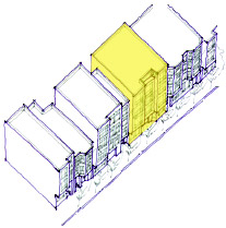
Although much of the eastern part of the East SoMa plan is already built out, a few remaining developable parcels remain. Development sites should step down in height towards the Bay,
POLICY 3.1.3
Relate the prevailing heights of buildings to street and alley width throughout the plan area.
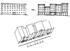
Generally, the height of buildings is set to relate to street widths throughout the plan area. An important urban design tool, in specific applications, is to frame streets with buildings or cornice lines that roughly reflect the street’s width. A core goal of the height districts is to create an urban form that will be intimate for the pedestrian, while improving opportunities for cost-effective housing and allowing for pedestrian-supportive ground floors.
POLICY 3.1.4
Heights should reflect the importance of key streets in the city’s overall urban pattern, while respecting the lower scale development that surrounds residential enclaves throughout the plan area.
Generally, the prevailing height of buildings is set to relate to street widths throughout the plan area. Height should also be used to emphasize key transit corridors and important activity centers. A primary intent of the height districts is to provide greater variety in scale and character while maximizing efficient building forms and enabling gracious ground floors.
The scale of development and the relationship between street width and building height offer an important orientation cue for users by indicating a street’s relative importance in the hierarchy of streets, as well as its degree of formality. Taller buildings with more formal architecture should line streets that play an important role in the City’s urban pattern.
Development along the many alleys, both in the Residential Enclaves and throughout the rest of East SoMa, should reflect the more intimate scale of these rights-of-way, ensuring a pedestrian-friendly, neighborhood-friendly, environment.
POLICY 3.1.5
Respect public view corridors. Of particular interest are the east-west views to the bay or hills, and several views towards the downtown.
San Francisco’s natural topography provides important wayfinding cues for residents and visitors alike, and views towards the hills or the bay enable all users to orient themselves vis-à-vis natural landmarks. Further, the city’s striking location between the ocean and the bay, and on either side of the ridgeline running down the peninsula, remains one of its defining characteristics and should be celebrated by the city’s built form.
POLICY 3.1.6
New buildings should epitomize the best in contemporary architecture, but should do so with full awareness of, and respect for, the height, mass, articulation and materials of the best of the older buildings that surrounds them.
Established patterns of rear-yard open spaces are to be protected.
Infill development should always strive to be the best design of the times, but should do so by acknowledging and respecting the positive attributes of the older buildings around it. Therefore, the new should provide positive additions to the best of the old, and not merely replicate the older architecture styles.
POLICY 3.1.7
Attractively screen rooftop HVAC systems and other building utilities from view.
POLICY 3.1.8
New development should respect existing patterns of rear yard open space. Where an existing pattern of rear yard open space does not exist, new development on mixed-use-zoned parcels should have greater flexibility as to where open space can be located.
POLICY 3.1.9
Preserve notable landmarks and areas of historic, architectural or aesthetic value, and promote the preservation of other buildings and features that provide continuity with past development.
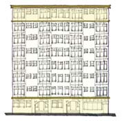
The historic and aesthetic qualities of buildings and districts that represent unique development patterns should be preserved.
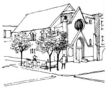
Important historic buildings cannot be replaced if destroyed. Their rich palette of materials and architectural styles imparts a unique identity to a neighborhood and provides valuable additions to the public realm. East SoMa demonstrates how adaptive reuse of historic buildings can provide a unique, identifiable, and highly enjoyed public place. Historic or otherwise notable buildings and districts should be celebrated, preserved in place, and not degraded in quality. See the Historic Preservation section of this area plan for specific preservation policies.
POLICY 3.1.10
After results are obtained from the historic resources surveys, make necessary adjustments to these built form guidelines to ensure that new structures, particularly in historic districts, will be compatible with the surrounding historic context.
POLICY 3.1.11
Establish and require height limits along alleyways to create the intimate feeling of an urban room.
Maintaining a pleasurable pedestrian environment along the street is an important element of the plan.
The alleyway network in East SoMa offers residents and visitors the opportunity to walk through one of the most intimately-scaled environments in San Francisco. This feeling of intimacy is established by carefully balancing building height and setbacks so as to ensure a sense of enclosure, while not overwhelming the senses.
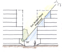
Heights at the property line along both sides of alleys should be limited. In general, building height at the property line must not exceed 1.25 times the width of the alley. Above this height, a minimum 10-foot setback is required to maintain the appropriate and desired scale.
POLICY 3.1.12
Establish and require height limits and upper story setbacks to maintain adequate light and air to sidewalks and frontages along alleys.
The narrowness of SoMa’s alleyways requires that development along them be carefully sculpted to proper proportions and to ensure that adequate light and air reach them and the frontages along them.
In addition to the building height and setback requirements stated in Policy 3.1.11 above, the building height at the property line along the southerly side of alleys must be setback so as to ensure a 45-degree sun access plane, as extended from the property line on the opposite side of the street to the top corner of each story.
Along both north-south and east west alleyways, setbacks are not required for the first 60 linear feet of the alley from the adjoining major street, as measured from the property line along the major street, so as to allow a proper streetwall along that street.
Alley controls will apply to all streets and alleys within the plan area.
OBJECTIVE 3.2
Promote an urban form and architectural character that supports walking and sustains a diverse, active and safe public realm.
The breakup of a large building’s mass into smaller sections enhances the pedestrian experience and provides for a more architecturally interesting structure. Because of the large parcelization pattern of many of Showplace’s blocks, strong articulation is particularly important.
Achieving an engaging public realm for East SoMa is essential. While visual interest is key to a pedestrian friendly environment, current development practice does not always contribute positively to the pedestrian experience, and many contemporary developments detract from it. Seeing through windows to the activities within – be they retail, commercial, or PDR – imparts a sense of conviviality that blank walls or garage doors are unable to provide. Visually permeable street frontages offer an effective and engaging nexus between the public and private domains, enlivening the street, offering a sense of security and encouraging people to walk. Where there are residential uses, seeing the activities of living is key, represented by stoops, porches, entryways, planted areas, and windows that provide “eyes on the street.”
POLICY 3.2.1
Require high quality design of street-facing building exteriors.
Buildings should have a clear bottom, middle and top. The building exterior of floors with retail or PDR uses should be differentiated visually from residential floors.
A. Provide strong, repeating vertical articulation on new buildings, especially those with large street frontages, to achieve the visual interest necessary to sustain pedestrian interest and activity. Avoid undifferentiated massing longer than 25 feet on residential streets or alleys, and 40 feet on all other streets. Such vertical articulation as this cannot be satisfactorily achieved by minor changes such as change of color alone.
B. For vertically mixed-use buildings, changes in use should be visually differentiated through changes in material, scale, setback or other means, and not solely by color.
C. Building openings and fenestration should represent the uses behind them, minimize visual clutter, harmonize with prevailing conditions, and provide architectural interest. Windows should have a minimum recess of 3 inches, generally should be oriented, and open, vertically, and the frames should not be made of vinyl.
D. Use authentic, materials with a substantial appearance, including wood, masonry, ceramic tile, pre-cast concrete or integrated stucco. Avoid using inauthentic materials, in particular those that have the appearance of thin veneer or attachment, such as EIFS or tilt-up panels. If used, inauthentic materials should not be the dominant façade material, and should not be used for detailing or ornamentation.
E. Brick, stone, tile, veneers or other applied materials should terminate logically and strongly, such as by wrapping corners and terminating at architectural modulations, articulations, frames or other features, so that they don’t appear superficially affixed to the façade.
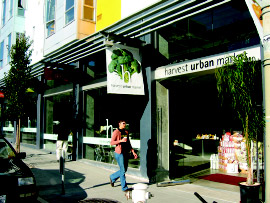
Active and visually permeable ground floors enliven the street environment for pedestrians.
F. Blank or blind frontages at the ground floor are highly discouraged and should be minimized wherever possible. Where necessary, frontages used for utilities, storage, refuse collection and other activities should be integrated into the overall articulation and fenestration of the façade, or be masked by landscaping or other design features where active uses are not possible.
G. Extended blank or blind frontages are not permitted along Transit Preferential Streets as defined in the General Plan, and within the 6th Street neighborhood commercial transit district, even if alternative street or alley frontage is not available.
POLICY 3.2.2
Make ground floor retail and PDR uses as tall, roomy and permeable as possible.
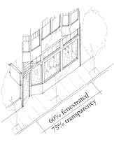
A. Maximize interior clear ceiling heights for ground floor retail or PDR uses. Where height districts end in five feet, such as 45’, 55’, 65’, and 85’, interior ground floor clear ceiling heights should maximize a fifteen foot envelope. This additional height will increase the flexibility of the space and improve its long-term viability.
B. Ground-level facades should be 75% transparent to permit a clear view inwards from the street and should not be tinted. Post construction alterations, such as retail displays, should not obscure the clear view.
POLICY 3.2.3
Minimize the visual impact of parking.
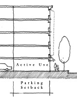
At-grade parking must be wrapped with at least 15 feet of active uses, such as retail or PDR.
A. Where off-street parking is provided, placing it underground should be encouraged wherever site conditions allow, and especially for development on lots exceeding 5,000 square feet. Underground parking should be consolidated for multiple properties, where opportunities arise, thereby reducing the average cost of construction and minimizing the number of curb cuts and garage entrances.
B. At grade parking is strongly discouraged. Where at-grade parking is necessary, it should be wrapped with a minimum of 15 feet of active use, such as residential, retail, or PDR on both the primary and secondary street frontages, except for the minimum frontage required for fire doors and parking access.
C. For development with no more than 20 units, parking access should be provided by a single door not exceeding 8 feet. Where lot dimensions require separate ingress and egress, individual doors and driveways should not exceed a width of eight feet and should be separated by one foot.
D. For developments with more than 20 residential units but less than 100 residential units, individual doors and driveways should not exceed a width of 8 feet for ingress and 8 feet for egress, separated by one foot, and should not be widened to allow for off-street loading. Combined ingress and egress should not exceed 16 feet. More than one ingress and one egress or one combined ingress/egress access point should be discouraged.
E. For developments with 100 residential units or more, individual doors and driveways should not exceed a width of 8 feet for ingress and 8 feet for egress for auto parking, separated by one foot, and 10 feet for ingress and 10 feet for egress for joint parking and loading. Based on the conditions above, a combined ingress and egress should not exceed 20 feet. More than one ingress and one egress or one combined ingress/egress access point should be discouraged.
F. The number of curb cuts should be kept to an absolute minimum, with no more than one lane for ingress and one lane for egress, regardless of the total amount of parking proposed. Parking and loading should share access lanes, wherever possible, rather than requiring separate doors and driveways.
G. Curb cuts are prohibited on Transit Priority Streets (TPS), in the 6th street neighborhood commercial transit district, and on 2nd Street, even if alternative street or alley frontage is not available.
H. Where a building has two frontages, parking entrances, loading docks, bays, and auxiliary service entrances should be accessed from secondary streets, and their visual impact on the neighborhood should be minimized.
POLICY 3.2.4
Strengthen the relationship between a building and its fronting sidewalk.
A. Blank and blind walls at the ground floor are highly discouraged and should be minimized. Building frontage should not be used for utilities, storage, and refuse collection wherever possible; where this function must be on the street, landscaping and other well-integrated design features should be used to enhance the street frontage.
B. Ground-floor units should be primarily accessed directly from the public way, and not through common corridors or lobbies. Upper story units should connect to a lobby entry that opens directly onto the public way. Where possible, units should not be accessed from an interior courtyard.
C. The individual entrances to ground-floor units should be set back 3-5 feet but no more than 10 feet from the street-fronting property line, and should be at least 18 inches, and ideally 3 feet, above sidewalk level.
D. All setback areas should maximize landscaping opportunities.
E. Utility vaults and access panels shall be placed in driveway curb cuts or at other locations so as to prevent blank building frontages and to ensure that sidewalk planting opportunities for street trees and landscaping are not limited.
F. Physically intimidating security measures such as window grills or spiked gates should be avoided; security concerns should be addressed by creating well-lit, well-used streets and active residential frontages that encourage “eyes on the street.”
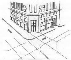
The design of corner buildings should relate to the civic significance of intersections.
POLICY 3.2.5
Building form should celebrate corner locations.
A. In use, design and entry, orient buildings towards corners.
B. Retail entrances should be located at corners, but primary residential entrances can be located away from the corner to prevent congestion.
C. Architectural features and detailing including towers, bays, and copulas at the corner are strongly encouraged.
POLICY 3.2.6
Sidewalks abutting new developments should be constructed in accordance with locally appropriate guidelines based on established best practices in streetscape design.
In dense neighborhoods such as East SoMa, streets can provide important and valued additions to the open space network, offering pleasurable and enjoyable connections for people between larger open spaces.
San Francisco’s Better Streets Plan will provide guidance on how to improve the overall urban design quality, aesthetic character, and ecological function of the city’s streets while maintaining the safe and efficient use for all modes of transportation.
POLICY 3.2.7
Strengthen the pedestrian network by extending alleyways to adjacent streets or alleyways wherever possible, or by providing new publicly accessible mid-block rights of way.
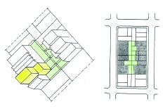
A. Developments on properties with 300 or more feet of street frontage on a block face longer than 400’ should provide a minimum 20-foot-wide publicly accessible mid-block right of way and access easement for the entire depth of the property, connecting to existing streets or alleys. This space can count towards the open space requirement.
B. Developments on properties with 200 feet or more, but less than 300 feet of street frontage should be encouraged to provide a minimum 20-foot wide publicly accessible easement where doing so would reconnect an alley with an adjacent street or another alley. This space can count towards the open space requirement.
C. Developments on properties with 100 feet or more, but less than 200 feet of street frontage in the middle one-third of a block face longer than 400’ where the adjacent property has the potential to do likewise, should be encouraged to provide a minimum 10-foot-wide publicly accessible mid-block right of way and access easement for the entire depth of the property, connecting to existing streets or alleys. This space can count towards the open space requirement.
POLICY 3.2.8
Ensure highest quality design for the remaining portions of former Sea Wall Lot 330.
The north-west corner of Assessor’s Block 3771, with a 22-story residential tower, is the only developed portion of former Sea Wall Lot 330 (a triangular-shaped lot bounded by Beale, Bryant, and The Embarcadero). The undeveloped portion of this triangular-shaped lot is currently surface parking. This remaining area is envisioned as having up to two elegant residential towers balancing out the existing residential tower at Beale and Bryant streets. The Port will work with the Planning Department to ensure that these new towers relate graciously to their waterfront location and exhibit highest-quality design given their prominent locations. The areas in-between these higher buildings should be filled with a lower 5-8 story podium that activates and engages the street, with residential stoops and operable windows opening directly onto Beale and Bryant streets and retail storefronts facing directly onto, and accessed along, The Embarcadero. The visual terminus of Beale Street at the Bay should be respected, and the connection to the waterfront enhanced, by maintaining both the southern-most corner of the lot and previous right of way free to light and air.
OBJECTIVE 3.3
Promote the environmental sustainability, ecological functioning and the overall quality of the natural environment in the plan area
Given the reality of global climate change, it is essential that cities, and development within those cities, limit their individual and collective ecological footprints. Using sustainable building materials, minimizing energy consumption, decreasing storm water runoff, filtering air pollution and providing natural habitat are ways in which cities and buildings can better integrate themselves with the natural systems of the landscape. These efforts have the immediate accessory benefits of improving the overall aesthetic character of neighborhoods by encouraging greening and usable public spaces and reducing exposure to environmental pollutants.
Specific policies and design guidelines to address the objective outlined above are as follows:
POLICY 3.3.1
Require new development to adhere to a new performance-based ecological evaluation tool to improve the amount and quality of green landscaping.
The San Francisco Planning Department, in consultation with the Public Utilities Commission, is in the process of developing a green factor. The green factor will be a performance-based planning tool that requires all new development to meet a defined standard for on-site water infiltration, and offers developers substantial flexibility in meeting the standard. A similar green factor has been implemented in Seattle, WA, as well as in numerous European cities, and has proven to be a cost-effective tool, both to strengthen the environmental sustainability of each site, and to improve the aesthetic quality of the neighborhood. The Planning Department will provide a worksheet to calculate a proposed development’s green factor score.
POLICY 3.3.2
Discourage new surface parking lots and explore ways to encourage retrofitting existing surface parking lots and off-street loading areas to minimize negative effects on microclimate and stormwater infiltration. The city’s Stormwater Master Plan, upon completion, will provide guidance on how best to adhere to these guidelines.
POLICY 3.3.3
Enhance the connection between building form and ecological sustainability by promoting use of renewable energy, energy-efficient building envelopes, passive heating and cooling, and sustainable materials
POLICY 3.3.4
Compliance with strict environmental efficiency standards for new buildings is strongly encouraged.
The positive relationship between building sustainability, urban form, and the public realm has become increasingly understood as these buildings become more commonplace in cities around the world. Instead of turning inwards and creating a distinct and disconnected internal environment, sustainable buildings look outward at their surroundings as they allow in natural light and air. In so doing, they relate to the public domain through architectural creativity and visual interest, as open, visible windows provide a communicative interchange between those inside and outside the building. In an area where creative solutions to open space, public amenity, and visual interest are of special need, sustainable building strategies that enhance the public realm and enhance ecological sustainability are to be encouraged.
4. Transportation
NOTE: The following Transportation objectives and policies relate specifically to the transportation system. Objectives and policies related to physical street design can be found in the Streets and Open Space chapter.
East SoMa’s proximity to downtown, dense mixed use development and elevated freeway (I-80) create an interaction of diverse transportation modes and systems. Pedestrians, bicycles and transit vehicles share streets with trucks and freeway traffic. Wide one-way streets like Howard, Folsom, Harrison and Bryant carry fast moving vehicles while pedestrians walk long blocks and narrow residential side streets and alleys. Buses and light rail operate on major transit streets such as Mission, 3rd/4th Streets, and The Embarcadero. The baseball stadium and the Caltrain Station at 4th & King Streets draw high volumes of transit riders, pedestrians and bicyclists. Transportation improvements in East SoMa involve increasing the safety, livability and multimodal capacity of streets while accommodating freeway traffic and truck circulation.
OBJECTIVE 4.1
IMPROVE PUBLIC TRANSIT TO BETTER SERVE EXISTING AND NEW DEVELOPMENT IN THE SOUTH OF MARKET
The East SoMa plan area as a whole is well served by local and regional public transit; however, stronger transit connections are needed to link key nodes throughout SoMa. Most of the existing transit service in the East SoMa is designed to provide access to the downtown area and Market Street via north-south lines. Service is also provided to connect East SoMa with Mission Bay and the Third Street corridor. South of Mission Street transit service connecting the East SoMa to other areas, including areas in the West SoMa and Showplace Square, is especially lacking. The transit service that is present is dispersed over the one-way street system and ill-defined. The City should improve and expand these transit connections as well as links to the 4th & King Caltrain Station and Market Street BART Stations.
South of Market lacks a strong transit corridor through the heart of district, one that might parallel Market Street further south. Folsom Street because of its location mid-way between Market and King Streets and its connection between areas planned for significant new development and residential population (Rincon Hill/Transbay, 4th Street, mid-SoMa, and portions of the Mission district) should be considered for transit service improvements. Additionally, SoMa lacks any grand civic “main streets.” Enhanced treatments for transit and pedestrians, consistent with overall transportation needs, as discussed further in the Streets and Open Space chapter of this Plan, should be explored in this corridor.
Major long term transit capital projects are planned for East SoMa. The San Francisco Municipal Transportation Agency’s (SFMTA) Central Subway project will extend the new Third Street light rail line from the Caltrain Station up 4th Street through downtown and into Chinatown. Throughout the community planning process, community members have expressed an interest in placing a stop between Bryant and Brannan Streets. The SFMTA’s plan includes a stop on 4th Street between Bryant and Brannan. In addition, SFMTA is exploring the feasibility of implementing a new E-line historic streetcar service from Fisherman’s Wharf to the Caltrain station. Both of these projects would significantly increase the mobility of residents and employees in East SoMa and support travel by transit rather than private automobile.
Beginning in 2008, the SFMTA, Planning Department and the San Francisco County Transportation Authority (SFCTA) will commence a comprehensive Eastern Neighborhoods Transportation Implementation Planning Study (EN TRIPS) to further explore the feasibility of the options described above, determine which projects are needed, how they should be designed and how they can be funded. A key input to this will be SFMTA’s “Transit Effectiveness Project” (TEP), the first comprehensive study of the Muni system since the late 1970s. The TEP aims to promote overall performance and long-term financial stability through faster, more reliable transportation choices and cost-effective operating practices. The TEP recommendations focus on improving transit service, speed and reliability and should be implemented as soon as possible within East SoMa.
The policies to address the objective outlined above are as follows:
POLICY 4.1.1
Commit resources to an analysis of the street grid, the transportation impacts of new zoning, and mobility needs in the South of Market / Eastern Neighborhoods to develop a plan that prioritizes transit while addressing needs of all modes (transit, vehicle traffic, bicyclists, pedestrians).
This policy refers to the Eastern Neighborhoods Transportation Implementation Planning Study described above.
POLICY 4.1.2
Decrease transit travel time and improve reliability through a variety of means, such as transit-only lanes, transit signal priority, transit “queue jumps,” lengthening of spacing between stops, and establishment of limited or express service.
POLICY 4.1.3
Implement the service recommendations of the Transit Effectiveness Project (TEP).
POLICY 4.1.4
Reduce existing curb cuts where possible and restrict new curb cuts to prevent vehicular conflicts with transit on important transit and neighborhood commercial streets
Curb cuts should be reduced on key neighborhood commercial, pedestrian, and transit streets, where it is important to maintain continuous active ground floor activity, protect pedestrian movement and retail viability, and reduce transit delay and variability. This is a critical measure to reduce congestion and conflicts with pedestrians and transit movement along Transit Preferential Streets, particularly where transit vehicles do not run in protected dedicated rights-of-way and are vulnerable to disruption and delay. In the East SoMa, streets to limit curb cuts include the proposed neighborhood commercial district along 6th Street as well as the Transit Preferential Streets listed in the Transportation Element of the General Plan.
POLICY 4.1.5
Ensure Muni’s storage and maintenance facility needs are met to serve increased transit demand and provide enhanced service.
Additional transit vehicles will be needed to serve new development in the Eastern Neighborhoods. The capacity of existing storage and maintenance facilities should be expanded and new facilities constructed to support growth in the Eastern Neighborhoods.
POLICY 4.1.6
Improve public transit linking the eastern and western portions of the South of Market and strengthen SoMa’s overall transit connections to the Market Street corridor, BART stations, and 4th & King Caltrain station.
POLICY 4.1.7
If the proposed Central Subway is built along the Fourth Street corridor, consider the inclusion of a stop on 4th Street between Bryant and Brannan.
POLICY 4.1.8
Support planning and implementation of the proposed E-line historic streetcar line from Fisherman’s Wharf to the 4th & King Caltrain Station.
OBJECTIVE 4.2
INCREASE TRANSIT RIDERSHIP BY MAKING IT MORE COMFORTABLE AND EASIER TO USE
A transit rider’s experience is largely impacted by the quality of environment in and around the stops and stations where they start or end their transit trips. Transit stops can be made more attractive and comfortable for riders through installation of bus bulbs, shelters, additional seating, lighting, and landscaping. Pedestrian safety should also be prioritized near transit through the installation and maintenance of signs, crosswalks, pedestrian signals and other appropriate measures. Quality passenger information and accurate real-time transit information should be provided. Key transit stops with high passenger volumes or high transfer volumes should be prioritized for enhanced amenities.
The policies to address the objective outlined above are as follows:
POLICY 4.2.1
Improve the safety and quality of streets, stops and stations used by transit passengers.
POLICY 4.2.2
Provide comprehensive and real-time passenger information, both on vehicles and at stops and stations.
OBJECTIVE 4.3
ESTABLISH PARKING POLICIES THAT IMPROVE THE QUALITY OF NEIGHBORHOODS AND REDUCE CONGESTION AND PRIVATE VEHICLE TRIPS BY ENCOURAGING TRAVEL BY NON-AUTO MODES
Many of the goals and objectives of this Plan depend heavily on how parking – both on and off street – is managed in the East SoMa. These goals include reduced congestion and private vehicle trips, improved transit, vibrant neighborhood commercial districts, housing production and affordability, and good urban design.
Elimination of minimum off-street parking requirements in new residential and commercial developments, while continuing to permit reasonable amounts of parking if desired, allows developers more flexibility in how they choose to use scarce developable space. In developments where space permits or where expected residents would particularly desire to own cars, parking can be provided, while in transit intensive areas, or where expected residents would not need cars (senior developments for example) parking would not be required. Space previously dedicated to parking in residential developments can be made available for additional housing units. With no parking minimums and therefore no need for individual drive-in parking spaces, new residential and commercial developments can explore more efficient methods of providing parking such as mechanical parking lifts, tandem or valet parking.
“Unbundling” parking from housing costs can reduce the cost of housing and make it more affordable to people without automobiles. The cost of parking is often aggregated in rents and purchase prices. This forces people to pay for parking without choice and without consideration of need or the many alternatives to driving available. This could be avoided by requiring that parking be separated from residential or commercial rents, allowing people to make conscious decisions about parking and auto ownership.
Proper management of public parking, both on-street and in garages is critical. Currently, on-street parking is difficult to find in many parts of the city. Loose regulation and relatively inexpensive rates increase demand and decrease turnover of parking spaces. This shifts demand away from public transit and other modes, increases congestion and encourages long term on-street parking by employees and commuters. To support the needs of businesses and create successful commercial areas, on-street parking spaces should be managed to favor short-term shoppers, visitors, and loading. In residential areas, curbside parking should be managed to favor residents, while allocating any additional spaces for short-term visitors to the area. Recent research has proposed a number of ways to use market-based pricing and other innovative management techniques to improve availability of on-street parking while also increasing the revenue stream to the city. These methods are currently under study and should be applied in this area.
In accordance with Section 8A.113 of Proposition E (2000), new public parking facilities can only be constructed if the revenue earned from a new parking garage will be sufficient to cover construction and operating costs without the need for a subsidy. New development built with reduced parking could accommodate parking needs of drivers through innovative shared parking arrangements like a “community parking garage.” Located outside of neighborhood commercial and small scale residential areas, such a facility would consolidate parking amongst a range of users (commercial and residential) while providing an active ground floor featuring neighborhood services and retail.
The policies to address the objective outlined above are as follows:
POLICY 4.3.1
For new residential development, provide flexibility by eliminating minimum off-street parking requirements and establishing reasonable parking caps.
POLICY 4.3.2
For new non-residential development, provide flexibility by eliminating minimum off-street parking requirements and establishing caps generally equal to the previous minimum requirements. For office uses in East SoMa, parking requirements should be commensurate with general downtown parking standards.
POLICY 4.3.3
Make the cost of parking visible to users, by requiring parking to be rented, leased or sold separately from residential and commercial space for all new major development.
POLICY 4.3.4
Encourage, or require where appropriate, innovative parking arrangements that make efficient use of space, particularly where cars will not be used on a daily basis.
POLICY 4.3.5
Permit construction of new parking garages in Mixed Use districts only if they are part of shared parking arrangements that efficiently use space, are appropriately designed, and reduce the overall need for off-street parking in the area.
POLICY 4.3.6
Reconsider and revise the way that on-street parking is managed in both commercial and residential districts in order to more efficiently use street parking space and increase turnover and parking availability.
The San Francisco County Transportation Authority is conducting the On-Street Parking Management and Pricing Study to evaluate a variety of improved management techniques for on-street parking and recommend which should be put into effect in San Francisco.
OBJECTIVE 4.4
SUPPORT THE CIRCULATION NEEDS OF EXISTING AND NEW PDR USES IN EAST SOMA
A significant share of deliveries to the South of Market are performed within the street space. Where curbside freight loading space is not available, delivery vehicles double-park, blocking major thoroughfares and creating potential hazards for pedestrians, cyclists and automobiles. The city should evaluate the existing on-street curb-designation for delivery vehicles and improve daytime enforcement to increase turnover. Where necessary, curbside freight loading spaces should be increased. During evenings and weekends, curbside freight loading spaces should be made available for visitor and customer parking. In new non-residential developments, adequate loading spaces internal to the development should be required to minimize conflicts with other street users.
The policies to address the objective outlined above are as follows:
POLICY 4.4.1
Provide an adequate amount of short-term, on-street curbside freight loading spaces throughout East SoMa.
POLICY 4.4.2
Continue to require off-street facilities for freight loading and service vehicles in new large non-residential developments.
POLICY 4.4.3
In areas with a significant number of PDR establishments, design streets to serve the needs and access requirements of trucks while maintaining a safe pedestrian environment.
OBJECTIVE 4.5
CONSIDER THE STREET NETWORK IN THE EAST SOMA AS A CITY RESOURCE ESSENTIAL TO MULTI-MODAL MOVEMENT AND PUBLIC OPEN SPACE.
Throughout SoMa, pedestrian-scaled alleys can be found tucked inside large blocks bordered by busy multi-lane streets. These alleys allow additional access to buildings, provide key short-cuts for pedestrians and cyclists, and can be an important source of open space. They should be preserved.
Once alleys are vacated and sold out of public ownership, they are gone forever and expensive or impossible to get back. The City should not vacate or sell this public space to private interests unless it is determined that removing excess roadway or reconfiguration of specific intersection geometries will achieve significant public benefits such as increased pedestrian safety, traffic safety, more reliable transit service or public open space. New developments on large lots should also be required to provide alleys that break up the scale of large buildings to improve street connectivity and pedestrian access.
The policies as well as implementing actions to address the objective outlined above are as follows:
POLICY 4.5.1
Maintain a strong presumption against the vacation or sale of streets or alleys except in cases where significant public benefits can be achieved.
POLICY 4.5.2
As part of a development project’s open space requirement, require publicly-accessible alleys that break up the scale of large developments and allow additional access to buildings in the project.
OBJECTIVE 4.6
SUPPORT WALKING AS A KEY TRANSPORTATION MODE BY IMPROVING PEDESTRIAN CIRCULATION WITHIN EAST SOMA AND TO OTHER PARTS OF THE CITY
The streets in the South of Market are primarily auto-oriented and present a variety of pedestrian safety and circulation challenges. The area’s freeway on and off-ramps designed to facilitate multiple lanes of turning traffic and wide turning radii can create intersections inhospitable to pedestrians. In some cases, pedestrian crossings are prohibited, making it inconvenient to cross the street. Missing sidewalks along streets such as Townsend Street from 4th to 7th Streets and alleys like Ritch Street should be installed to improve pedestrian access and safety.
The block pattern in SoMa is much larger than elsewhere in the city, with double the typical distance between intersections. This encourages uncontrolled jaywalking across wide, busy streets and otherwise requires pedestrians to walk out of their way. Prominent signalized mid-block crosswalks should be considered on streets like Howard, Folsom and other parallel streets. Wherever possible, the City should implement high-visibility crosswalks, pedestrian signal heads with countdown timers, corner bulbouts, median refuge islands, or other pedestrian improvements. In specific areas with known higher rates of pedestrian-collisions, developers should be encouraged to carry out context specific planning and design of building projects to improve pedestrian safety.
Second Street is currently designated in the General Plan as the primary pedestrian corridor in East SoMa connecting Market Street to King Street. This street features local transit lines and has active, small-scale commercial activity at the southern end where it runs through a historic district. Because it is discontinuous north of Market Street and south of King Street, 2nd Street is less of a major auto artery than other nearby parallel streets, such as 3rd Street. However few improvements have been made to the street in recognition of these policy designations and uses. Consideration should be given to pedestrian improvements such as streetscape design and bus bulbouts.
While 2nd Street is the designated north-south pedestrian corridor in East SoMa, both 3rd and 4th Streets connect to Mission Bay to the south and Union Square to the north. The planned Central Subway along 4th Street also brings about an opportunity to enhance the surrounding pedestrian environment to facilitate access and encourage use. Consideration should be given to creation of streetscape plans that address improvements to pedestrian conditions and safety.
The Planning Department is currently working with the SFMTA to develop the Better Streets Plan to ensure that streets are designed to promote pedestrian comfort and safety. This joint effort will provide a framework for all future pedestrian improvements on the city’s streets. (See also the Streets and Open Space chapter in this Plan, where there is more in-depth discussion on the physical design of streets.)
The policies to address the objective outlined above are as follows:
POLICY 4.6.1
Use established street design standards and guidelines to make the pedestrian environment safer and more comfortable for walk trips.
POLICY 4.6.2
Prioritize pedestrian safety improvements in areas and at intersections with historically high frequencies of pedestrian injury collisions.
POLICY 4.6.3
Consider improvements that target barriers to walking in SoMa such as long blocks and closed crosswalks, particularly at freeway on and off-ramps.
POLICY 4.6.4
Consider pedestrian and streetscape improvements to major pedestrian streets and commercial corridors connecting downtown to Mission Bay, especially Pedestrian Streets identified in the General Plan.
POLICY 4.6.5
Facilitate completion of the sidewalk network in East SoMa, especially where new development is planned to occur.
OBJECTIVE 4.7
IMPROVE AND EXPAND INFRASTRUCTURE FOR BICYCLING AS AN IMPORTANT MODE OF TRANSPORTATION
Bicyclists in SoMa, like pedestrians, face the challenge of a street grid dominated by one-way streets, fast moving traffic and freeways. Improvements to the area’s bicycle route network will help strengthen the multi-modal function of East SoMa’s streets.
East SoMa’s existing bicycle lanes provide good east-west access through the heart of SoMa along Folsom and Howard Streets. However, bicycle facilities are scarce below Folsom Street. A wide gap also exists in north-south connections between the bicycle lanes along the Embarcadero and on 7th and 8th Streets. As part of the city’s Bicycle Plan, the SFMTA has proposed installing new bicycle lanes on 2nd Street between King and Market Streets, 5th Street between Market and Townsend Streets, Townsend Street between 8th Street and The Embarcadero, and a southbound bicycle lane on Beale Street between Bryant and Folsom Streets, a southbound bicycle lane on Fremont Street between Folsom and Harrison Streets, and a westbound bicycle lane on Howard Street between The Embarcadero and Fremont Street. These proposals should be implemented once the Bicycle Plan achieves environmental clearance.
Recent citywide zoning code amendments require bicycle parking for all new developments. On-street bicycle parking should continue to be expanded to serve shoppers, employees and residents. Secure bicycle parking like the Bike Station provided at the Caltrain station at 4th & King helps facilitate intermodal connections and transit use.
The policies to address the objective outlined above are as follows:
POLICY 4.7.1
Provide a continuous network of safe, convenient and attractive bicycle facilities connecting SoMa to the citywide bicycle network and conforming to the San Francisco Bicycle Plan.
POLICY 4.7.2
Provide secure, accessible and abundant bicycle parking, particularly at transit stations, within shopping areas and at concentrations of employment.
OBJECTIVE 4.8
ENCOURAGE ALTERNATIVES TO CAR OWNERSHIP AND THE REDUCTION OF PRIVATE VEHICLE TRIPS
In addition to investments in our transportation infrastructure, there are a variety of programmatic ways in which the City can encourage people to use alternative modes of travel. Car sharing and transportation demand management programs (TDM) are important tools to reduce congestion and limit parking demand.
Car sharing offers an affordable alternative to car ownership by allowing individuals the use of a car without the cost of ownership (gas, insurance, maintenance). Car sharing companies provide privately owned and maintained vehicles for short-term use by their members. Car share members pay a flat hourly rate or monthly fee to use cars only when they need them (i.e. to run errands or make short trips).
Recent zoning code changes require car share spaces in new residential developments. Locating car share spaces and vehicles in new and existing developments helps to provide an attractive and convenient alternative to automobile ownership. As a dense neighborhood with good access to local and regional transit, additional spaces in East SoMa should be encouraged.
Transportation Demand Management (TDM) combines marketing and incentive programs to reduce dependence on automobiles and encourage use of a range of transportation options, including public transit, bicycling, walking and ridesharing. Potential TDM programs employers should introduce in the Eastern Neighborhoods include “Cash-out” policies (where employers provide cash instead of a free parking space), Commuter Checks and Emergency Ride Home programs.
Businesses and institutions with large numbers of employees or students should be required to develop on-site transportation demand management programs or join in a larger area-wide program such as San Francisco Transportation Management Association (TMA). Major residential developments (50+ units) could be required to provide transit passes to all residents as part of rent or homeowner association fees.
The policies to address the objective outlined above are as follows:
POLICY 4.8.1
Continue to require car-sharing arrangements in new residential and commercial developments, as well as any new parking garages.
POLICY 4.8.2
Require large retail establishments, particularly supermarkets, to provide shuttle and delivery services to customers.
POLICY 4.8.3
Develop a Transportation Demand Management (TDM) program for the Eastern Neighborhoods that provides information and incentives for employees, visitors and residents to use alternative transportation modes and travel times.
OBJECTIVE 4.9
FACILITATE MOVEMENT OF AUTOMOBILES BY MANAGING CONGESTION AND OTHER NEGATIVE IMPACTS OF VEHICLE TRAFFIC
New development in East SoMa will generate additional travel in and through the area. Since many new trips in the area are expected to occur by public transit, walking and biking, efforts should be made to accommodate new vehicle traffic while reducing conflicts with pedestrians or transit.
The Eastern Neighborhoods Transportation Implementation Planning Study should explore opportunities to calm traffic on select streets in the South of Market, restore their multimodal function and improve neighborhood livability. The feasibility of eliminating traffic lanes and converting one-way streets to two-way should be examined. The important role the South of Market’s streets play in the mobility of the entire city and region as conveyors of freeway traffic must also be recognized. Traffic calming projects should be implemented to reduce speeding and improve safety, without introducing delay or reliability problems for transit.
New technologies such as those being developed by the Department of Parking and Traffic’s “SFGO” program should be pursued to reduce congestion, respond to current traffic conditions and move autos safely and efficiently.
The policies to address the objective outlined above are as follows:
POLICY 4.9.1
Introduce traffic calming measures where warranted to improve pedestrian safety and comfort, reduce speeding and traffic spillover from arterial streets onto residential streets and alleyways.
POLICY 4.9.2
Decrease auto congestion through implementation of Intelligent Traffic Management Systems (ITMS) strategies such as smart parking technology, progressive metering of traffic signals and the SFMTA “SFGO” program.
OBJECTIVE 4.10
DEVELOP A COMPREHENSIVE FUNDING PLAN FOR TRANSPORTATION IMPROVEMENTS
New development in East SoMa and throughout the Eastern Neighborhoods will exert significant strain on the area’s existing transportation infrastructure. The City must develop new funding sources and a funding plan to ensure needed improvements are made.
Transportation improvements are costly. While federal, state, regional and local grant sources are available to partially defray the cost of transportation capital projects, they are not sufficient to meet transportation needs identified by the community. Streets and transportation improvements (pedestrian, bicycle, and transit) will require a significant portion of the funding generated through the Eastern Neighborhoods Public Benefits Program. Because funds from this program will also be needed to support a number of other community improvements beside transportation, it will be important to identify additional sources of funding.
The policies to address the objective outlined above are as follows:
POLICY 4.10.1
As part of the Eastern Neighborhoods Public Benefits Program, pursue funding for transit, pedestrian, bicycle and auto improvements through developer impact fees, in-kind contributions, community facilities districts, dedication of tax revenues, and state or federal grant sources.
MAP 3 - Eastern Neighborhoods Public Transit Improvements Concept
MAP 4 - Eastern Neighborhoods Pedestrian/Bicycle/Traffic Calming Improvements
5. Streets and Open Space
East SoMa has a deficiency of open spaces serving the neighborhood. Substantial parts of the East SoMa historically have been predominantly industrial, which has meant that many areas are not within walking distance to an existing park and many areas lack adequate places to recreate and relax. With the addition of new residents, this deficiency will only be exacerbated. Thus, one of the primary objectives of this Plan is to provide more open space to serve both existing and new residents, workers and visitors. Analysis reveals that a total of about 4.2 acres of new space should be provided in this area to accommodate expected growth. This Plan proposes to provide this new open space by creating at least one substantial new park site in the East SoMa. In addition the Plan proposes to encourage some of the private open space that will be required as part of development to be provided as public open space and to utilize our existing rights-of-way to provide pocket parks.
OBJECTIVE 5.1
PROVIDE PUBLIC PARKS AND OPEN SPACES THAT MEET THE NEEDS OF RESIDENTS, WORKERS AND VISITORS
In a built-out neighborhood such as this, finding sites for sizeable new parks is difficult. However, it is critical that at least one new substantial open space be provided as part of this Plan. The Planning Department will continue working with the Recreation and Parks Department to identify a site in the East SoMa for a public park and will continue to work to acquire additional open spaces.
The Port has also developed a number of proposals for open space adjacent to the East SoMa planning area. The Brannan Street Wharf is proposed to replace the dilapidated Pier 36 and former Pier 34 and marginal wharf with a new public wharf open space. Park features, as recommended by a citizen advisory committee convened for the Brannan Street Wharf project, include a neighborhood green space, a public float for small boats, and seating and picnic areas. The Port is also considering a shoreline park as part of the mixed use developed proposed for Seawall lot 337.
In order to provide this park, significant funding will need to be identified to acquire, develop, and maintain the space. One source of funds would be impact fees or direct contributions from new development. New residential development directly impacts the existing park sites with its influx of new residents, therefore new residential development will be required to pay directly into a fund to acquire new open space. Funding for the proposed Port open space projects is also needed, though the majority of the funding for the proposed Brannan Street Wharf is available and the Port has proposed a bond to complete the additional funding necessary to complete the project.
Commercial development also directly impacts existing park sites, with workers, shoppers and others needing places to eat lunch and take a break outside. This Plan also proposes to charge an impact fee for commercial development to cover the impact of proposed commercial development.
The policies to address the objective outlined above are as follows:
POLICY 5.1.1
Identify opportunities to create new public parks and open spaces and provide at least one new public park or open space serving the East SoMa.
POLICY 5.1.2
Require new residential and commercial development to contribute to the creation of public open space.
OBJECTIVE 5.2
ENSURE THAT NEW DEVELOPMENT INCLUDES HIGH QUALITY PRIVATE OPEN SPACE
In addition to the publicly accessible open space requirements, another tool for making East SoMa greener is to require additional private open space. Currently, residential developments are required to provide open space accessible to residents. In East SoMa this requirement is much lower than any other neighborhood in the city where residential uses are allowed. This Plan increases the open space required as part of new developments to be similar to what is currently required in other neighborhoods.
Additionally, commercial development is currently required to provide open space in SoMa. Existing requirements in SoMa for commercial development establish a minimum amount of open space to be provided on-site, or project sponsors may elect to pay an in-lieu fee. Because these fees are low, project sponsors often elect to pay the fee. This plan proposes to reexamine the current requirements for commercial development to provide adequate, usable open space, and also increase the in-lieu fee if project sponsors choose not to provide this space.
In small-scale residential developments in this area, open space is provided as backyards. Currently many of the blocks -- especially the interior blocks and the residential alleys -- of East SoMa have a rear yard pattern similar to many of the residential neighborhoods in the city. Taken together in the center of a block, these rear yards provide a sense of visual relief and access to open space in this part of the city. In areas where the existing pattern is one of rear yards, this pattern should be maintained. However, in areas where rear yards do not predominate, new residential developments should provide open space in a manner that best fits the characteristics of the particular site, while still ensuring high quality open space design.
The quality of the private open space is also being reexamined in the East SoMa. Currently, open space is often provided as sterile hardscape atop a building’s podium. By employing the new performance-based evaluation tool, discussed in greater detail in the Built Form section of this Area Plan, required open space will be made greener, more ecologically sustainable, and more enjoyable for residents.
The policies to address the objective outlined above are as follows:
POLICY 5.2.1
Require new residential and mixed-use residential development to provide on-site private open space designed to meet the needs of residents.
POLICY 5.2.2
Strengthen requirements for commercial development to provide on-site open space.
POLICY 5.2.3
Encourage private open space to be provided as common spaces for residents and workers of the building wherever possible.
POLICY 5.2.4
Encourage publicly accessible open space as part of new residential and commercial development.
POLICY 5.2.5
New development should respect existing patterns of rear yard open space. Where an existing pattern of rear yard open space does not exist, new development on mixed-use-zoned parcels should have flexibility as to where open space can be located.
POLICY 5.2.6
Ensure quality open space is provided in flexible and creative ways, adding a well used, well-cared for amenity for residents of a highly urbanized neighborhood. Private open space should meet the following design guidelines: A. Designed to allow for a diversity of uses, including elements for children, as appropriate. B. Maximize sunlight exposure and protection from wind C. Adhere to the performance-based evaluation tool.
In new mixed use developments, common, unenclosed residential open space areas can be provided as a rear yard, rooftop garden, central courtyard, balcony, or elsewhere on the lot or within the development so long as it is clearly accessible and usable by residents. Landscaping visible from the street is encouraged. Common spaces are encouraged over private spaces.
OBJECTIVE 5.3
CREATE A NETWORK OF GREEN STREETS THAT CONNECT OPEN SPACES AND IMPROVES THE WALKABILITY, AESTHETICS AND ECOLOGICAL SUSTAINABILITY OF THE NEIGHBORHOOD
In a built out neighborhood such as East SoMa, acquiring sites for new large parks can be difficult. For this reason, in addition to the acquisition of at least one park site in the neighborhood, the East SoMa Area Plan proposes an open space network of “Green Connector” streets, with wider sidewalks, places to sit and enjoy, significant landscaping and gracious street trees that would provide linkages between larger open spaces and diffuse the recreational and aesthetic benefits of these spaces into the neighborhood. Reconfiguring many of East SoMa’s wide, heavily trafficked streets that currently satisfy the needs of private vehicles over the needs of pedestrians and cyclists would go far towards creating a more livable neighborhood for residents, workers, and visitors.
The East SoMa Area Plan calls for a fundamental rethinking of how the city designs and uses its streets. In addition to Green Connector streets, smaller streets and alleys can provide a welcomed respite from the busy activities along major streets. These alleyways are proposed to be converted into “living streets,” where through-traffic is calmed and paving and landscaping are designed to reflect what is envisioned as the pedestrian primacy of these streets. (See Map 5 - The Eastern Neighborhoods Open Space Concept Map) The Planning Department is currently working with the Redevelopment Agency and the Department of Public Works on the redesign of Minna, Natoma and Russ Streets between 6th and 7th Streets. These streets will set the standard for additional living streets to be designed throughout the plan area. Similarly, lightly used alleyways with a more mixed-use or commercial character could be converted into lunchtime malls where outdoor dining could be moved into the street area. The Downtown Plan provides precedent; with new businesses and offices in parts of East SoMa, serving lunchtime demands for public space becomes increasingly important.
In dense neighborhoods such as East SoMa, it is increasingly clear that streets can and should provide important and valued additions to the open space network and aesthetic quality of the area. The design and maintenance of all other streets throughout the plan area should be guided by the forthcoming Better Streets Plan, a policy document that will provide direction on how to improve the overall urban design quality, aesthetic character, and ecological function of the city’s streets while maintaining safe and efficient use for all modes of transportation. The Better Streets Plan will provide guidance for both public and private improvements to the streetscape. The East SoMa Area Plan, in addition to the Better Streets Plan, will generate amendments to the Planning Code to make more explicit the requirements of private developers to construct and maintain a more enjoyable, more beautiful pedestrian environment.
In addition to these general streetscape improvements along streets, specific design interventions should also be considered for major intersections. As evidenced throughout the plan area, where major intersections are often two one-way streets of speeding through traffic framed on four corners by single-story buildings, these places are unfriendly to the walker and cyclist. To better foster a sense of place and to improve the pedestrian experience, significant public space improvements - such as bulb-outs and landscaping treatments - should be focused at these intersections. Additionally, as described in the Built Form chapter of this Plan, specific effort should be paid to improving the quality, design, massing, and scale of corner buildings to better reflect the civic importance of major street intersections.
The East SoMa Area Plan also calls for three interventions that are aimed at connecting East SoMa’s open space network to that of the city as a whole. The first is a Civic Boulevard such as Folsom Street, connecting the emerging Transbay and Rincon Hill Areas, East and West SoMa, and the Mission District. A Civic Boulevard would be a green street linking public open spaces, cultural and social destinations, and transit connections. It would be heavily landscaped with a strong design aesthetic, with pocket parks, plazas, and spaces for cafes and neighborhood retail lining the entire corridor, with wide sidewalks and a distinctive lighting character.
Second, primary pedestrian connections between neighborhoods are to be strengthened. Second Street is a currently designated pedestrian connector between the Downtown, East SoMa, and the Ballpark. This street has specific design controls aimed at fostering an enjoyable pedestrian environment, such as minimizing shade, maximizing sidewalk width, and providing agreeable pedestrian amenities such as lighting and street furniture. The East Soma Area Plan extends these controls to 3rd, 4th, and 7th Streets as well as to all Transit Priority Streets.
Third, this Area Plan supports the development of the Blue Greenway, as discussed further in the Transportation chapter of the Plan. The Blue Greenway is a 13 mile recreational corridor that would run along the Bay – perhaps East SoMa’s greatest natural asset – providing a connection between the Embarcadero and China Basin all the way to Candlestick Point, as a necklace of small waterfront parks, pathways, and promenades.
Finally, an important consideration for East SoMa is the visual and functional dominance of the elevated freeway infrastructure. To soften this dominance and to improve connections under the freeway, the City is working with Caltrans to provide landscaping along the freeway and at on and off ramps, as well as architectural lighting. This lighting should be both energy efficient and designed to minimize light spill into abutting neighborhoods. Decorative lighting along the suspension cables of the Bay Bridge, for example, provides a strong sense of character and visual identity. Such lighting should be continued along the 80/101 corridor as it cuts through East SoMa.
The policies to address the objective outlined above are as follows:
POLICY 5.3.1
Redesign underutilized portions of streets as public open spaces, including widened sidewalks or medians, curb bulb-outs, “living streets” or green connector streets.
POLICY 5.3.2
Maximize sidewalk landscaping, street trees and pedestrian scale street furnishing to the greatest extent feasible.
POLICY 5.3.3
Design the intersections of major streets to reflect their prominence as public spaces.
POLICY 5.3.4
Enhance the pedestrian environment by requiring new development to plant street trees along abutting sidewalks. When this is not feasible, plant trees on development sites or elsewhere in the plan area.
POLICY 5.3.5
Significant above grade infrastructure, such as freeways, should be retrofitted with architectural lighting to foster pedestrian connections beneath.
POLICY 5.3.6
Where possible, transform unused freeway and rail rights-of-way into landscaped features that provide a pleasant and comforting route for pedestrians.
POLICY 5.3.7
Develop a comprehensive public realm plan for East SoMa that reflects the differing needs of streets based upon their predominant land use, role in the transportation network, and building scale.
POLICY 5.3.8
Consider transforming a major east-west street in the South of Market into a civic boulevard, connecting the Bay to the Mission District.
POLICY 5.3.9
Explore opportunities to identify and expand connections to the Bay Trail.
OBJECTIVE 5.4
THE OPEN SPACE SYSTEM SHOULD BOTH BEAUTIFY THE NEIGHBORHOOD AND STRENGTHEN THE ENVIRONMENT
Open space not only provides places to recreate and relax, but also provides a means to strengthen the environmental quality of the neighborhood. As discussed in the Built Form chapter of this Plan, one tool for greening private open spaces is the performance-based evaluation tool. This tool requires all new development to meet a defined standard for on-site water infiltration, and offers developers a large number of strategies to meet the standard.
Ecological sustainability is also a key goal in the development of public spaces. Some new public spaces will be created through the reclamation of the excess street rights-of-way throughout East Soma. Turning these concrete and impermeable surfaces into pocket parks and plantings will not only beautify the street, it will also provide greater on-site water filtration. Additionally, new public parks that are being acquired will consider incorporating ecological sustainability elements, such as bioswales and natural areas.
In addition to the on-site menu of options available to project sponsors as part of the performance-based evaluation tool, there are many additional measures that can create a better environment. Built out, urban areas such as San Francisco can improve existing water quality of our bays and oceans by encouraging more on-site infiltration. Pervious surfaces, such as parking lots, are one of the main causes of pollution flowing directly into these water resources and one of the easiest sources to make more permeable. Permeability allows the water to be filtered through the soil before reaching the bay or the ocean. An ongoing master planning process being conducted by the San Francisco’s Public Utility Commission (PUC) will provide guidance on how best to mitigate stormwater flow into the city’s sewers, for example, by designing surface parking and loading areas to infiltrate rainwater onsite, rather than sending it into the drain.
Public art can be a component of existing and proposed open spaces that enhance the spaces and relate them to the existing neighborhoods. For example, a rotating art public art exhibit such as the one at Victoria Manolo Draves Park adds a locally relevant cultural element to the new park.
The policies to address the objective outlined above are as follows:
POLICY 5.4.1
Increase the environmental sustainability of East SoMa’s system of public and private open spaces by improving the ecological functioning of all open space.
POLICY 5.4.2
Explore ways to retrofit existing parking and paved areas to minimize negative impacts on microclimate and allow for storm water infiltration.
POLICY 5.4.3
Encourage public art in existing and proposed open spaces.
OBJECTIVE 5.5
ENSURE THAT EXISTING OPEN SPACE, RECREATION AND PARK FACILITIES ARE WELL MAINTAINED
Throughout the community planning process participants have given a high priority to maintaining and renovating existing park facilities. Maintenance needs will only become more apparent with the acquisition of a new park and as more open spaces such as green connector streets, living streets, and pocket parks are constructed. These types of spaces are often more complex and therefore generally more difficult to maintain on a per square foot basis then an open field, so the city should work to find space for maintenance equipment in the East SoMa area and to assure that maintenance funding and funding to renovate existing parks is provided with the development of these spaces.
This plan proposes to renovate at least one existing park by securing the funding through impact fees and other sources. Specifically in East SoMa, the SoMa Eugene Friend Recreation Center and South Park are both in need of renovation and should be prioritized. (See Map 5 - Eastern Neighborhoods Streets and Open Space Concept Map) The Recreation and Parks Department is now using safe, durable and long lasting materials and are designing facilities appropriately for the intended uses and these efforts will result in fewer repairs, longer and expanded usage periods and more reliable facilities. New public parks and re-designs of existing public parks should maximize drought tolerant landscaping and minimize features that require regular irrigation. Native species are encouraged, where appropriate.
There are also opportunities to more efficiently and creatively use existing facilities such as school playgrounds in the East SoMa. The Mayor’s Office and the San Francisco Unified School District have recently begun a pilot program to open one school playground in each supervisorial district for use on weekends and select holidays. This program better utilizes our existing resources and the city should continue to work with the School District to expand this program and to allow additional recreational resources for the neighborhood.
The policies to address the objective outlined above are as follows:
POLICY 5.5.1
Prioritize funds and staffing to better maintain existing parks and obtain additional funding for a new park and new open space facilities.
POLICY 5.5.2
Renovate run-down or outmoded park facilities to provide high quality, safe and long-lasting facilities. Identify at least one existing park or recreation facility in East SoMa for renovation.
POLICY 5.5.3
Explore opportunities to use existing recreation facilities, such as school yards, more efficiently.
POLICY 5.5.4
Encourage public art in existing and proposed open spaces.
6. Economic Development
Economic development should create sustainable prosperity for the residents, workers, and businesses of San Francisco. As described in the San Francisco Economic Strategy, such sustainable prosperity includes increasing job growth, wages and tax revenue, and small business development; while decreasing economic inequality and out-migration of businesses.
Attaining these goals involves determining the relationships that link government policy, industry competitiveness, and economic outcomes. From a government policy standpoint, these relationships are manifested in three ways:
-
by focusing on the land, through the City’s land use strategy and zoning
-
by focusing on our businesses, through the City’s business assistance programs
-
by focusing on our workers, through the City’s workforce development programs and other mechanisms to promote economic self-sufficiency for workers.
This chapter will focus on objectives for supporting businesses and workers, while the land use-related economic development objectives are reflected in the Land Use chapter of this Plan.
OBJECTIVE 6.1
support the economic wellbeing of A VARIETY OF BUSINESSES IN THE EASTERN NEIGHBORHOODS
Business assistance forms a vital part of an overall strategy to help San Francisco’s business sectors grow, compete and succeed. Business assistance is provided by a city or a non-profit organization and often broadly includes start-up assistance, ongoing technical assistance, assistance navigating city government processes, financial assistance, real estate and site selection assistance, assistance accessing workforce and incentive programs and assistance forming sector specific industry associations or organizations. In the Eastern Neighborhoods, there are three broadly defined industries: Physical Infrastructure; the Knowledge Sector, and the Small Business Sector.
The physical infrastructure sector includes production, distribution and repair (PDR) businesses that share key characteristics, such as the need for flexible, industrial space and their role in providing goods and services that support other primary industries in San Francisco (such as tourism, retail, high technology, and office-based industries). Providing business assistance to businesses in the physical infrastructure sector is important because these businesses are critical to the city’s economy. Specifically:
-
These jobs tend to pay above average wages, provide jobs for residents of all education levels and offer good opportunities for advancement.
-
These businesses support our Knowledge Sectors by providing critical business services that need to be close, timely and often times are highly specialized.
-
The products produced in this sector provide a valuable export industry in the city. Businesses that manufacture products in San Francisco often do so because of the city’s unique combination of location, talent, and proximity to clients.
While protecting physical infrastructure businesses and other vulnerable uses, space should be provided in the Eastern Neighborhoods for “Knowledge Sector” businesses. (See Land Use chapter.) Broadly speaking, the Knowledge Sector describes businesses that create economic value because of the knowledge they possess and generate for their customers. Knowledge Sector business assistance is important because most Knowledge Sector industries have the highest fiscal impacts of any industry in the local economy. Specifically:
-
Citywide, the Knowledge Sector provides the majority of San Francisco’s high-wage jobs and can provide above-average paying jobs for workers without a four-year degree.
-
The Knowledge Sector creates significant multiplier effects for local-serving businesses and City payroll taxes.
-
The strength of the Knowledge Sector will play a large part in determining the trajectory of the entire City economy.
Small businesses are generally defined as businesses with a total workforce of 100 or fewer employees and include sole-proprietors who have no employees. Small business assistance is important because small businesses represent a significant and growing portion of the city economy. Specifically
-
Small businesses account for over 95% of the companies in San Francisco and one out of every three jobs.
-
The growth in the number of small business has created an alternative to salaried employment for many San Francisco residents, and has the potential to address the city's high rates of asset poverty and economic insecurity.
-
Small businesses that start in San Francisco tend to grow and expand in San Francisco, creating more jobs and revenue for the city.
Providing business assistance to PDR businesses, Knowledge Sector businesses and small businesses is important in achieving the broader economic and workforce objectives of the city as defined in the city’s Economic Strategy. The high cost of doing business in San Francisco, and perceptions of an unfriendly business climate, are cited as barriers to business growth and economic development in the city. If the city is to retain PDR, Knowledge Sector and small businesses as they grow—and benefit from the greater range of jobs that large firms offer—then it must work to offer a competitive business climate. Business assistance services are a vital part of an overall strategy to strengthen the overall business climate and help these business sectors grow.
The policies to address the needs highlighted above are as follows:
POLICY 6.1.1
Provide business assistance for new and existing PDR businesses in the Eastern Neighborhoods.
POLICY 6.1.2
Provide business assistance for new and existing Knowledge Sector businesses in the Eastern Neighborhoods.
POLICY 6.1.3
Provide business assistance for new and existing small businesses in the Eastern Neighborhoods.
OBJECTIVE 6.2
INCREASE ECONOMIC SECURITY FOR WORKERS BY PROVIDING ACCESS TO SOUGHT-AFTER JOB SKILLS
Workforce development efforts - including job preparation, occupational skills training, and other strategies - are designed to provide individuals with the skills and knowledge necessary to access and retain quality jobs in a competitive economy. Skills development is key to helping workers move toward economic self-sufficiency through jobs that are in demand in our local and regional economies. Supporting the development of job skills benefits individual workers and their families, and also benefits companies that do business in San Francisco.
Because of the complex and changing nature of our economy, it is important that our workforce development strategies are aligned with the needs of industry - matching job training with the skills needed by employers. This is the match that will ensure that all San Francisco residents - particularly those that are low-income and/or may experience barriers to employment - are prepared for jobs as a result of their training. The workforce success of all San Francisco residents is essential to sustainable economic development and reducing inequality in San Francisco.
Workforce development strategies will target a range of established and growing industries. These industries reflect the breadth of San Francisco’s economy, and include Physical Infrastructure jobs and Knowledge Sector jobs (as discussed above), as well as those that are more involved in the “Experience Sector” (i.e., tourism and hospitality) and human services. These sectors are specifically targeted because of their ability to pay above-average wages to well-trained workers, even if those workers do not have a four-year degree. Employers range from small neighborhood serving businesses to large and mature companies.
The policy to address the needs highlighted above is as follows:
POLICY 6.2.1
Provide workforce development training for those who work in and live in the Eastern Neighborhoods, particularly those who do not have a college degree.
7. Community Facilities
Community facilities are key elements that can help to create a strong sense of community and identity. They are an integral element of socially and sustainable communities and they include community anchors like schools and libraries, child care facilities, community centers (where youth, after school, and other activities can occur), cultural and arts centers, clinics and a range of other amenities. Community facilities can include any type of service needed to meet the day-to-day needs of the community. In the Eastern Neighborhoods these facilities can provide language/communication curricula, programs to address education gaps, job skills and training, tutoring and youth development, cultural resource centers, and the support networks often so critical for lower income communities. Specific needs might include multicultural programs, legal aid, information and referrals, various parenting groups, immigration adaptation and settlement, etc.
Some community facilities critical to neighborhood development, such as streets, open space, housing and transportation, are addressed specifically in other sections of this Area Plan. This Community Facilities chapter includes the remaining needs and attempts to address how they will be met either through traditional land use regulations or through other methods to fund, encourage and maintain them. In the Eastern Neighborhoods, the expected level of need for these community facilities is based on existing needs as well as future ones, derived from projected population growth and new development demand. Recommendations towards expansion or improvements to community facilities are based on this assessment, as well as on conversations with the community and with typical providers of these community services. The policies that follow will be accompanied by a separate implementation document, which will outline funding strategies and public benefit funds available for such facilities, and provide direction for their execution. The plan will also include a monitoring strategy to assess changes in needs so that the pool of funds for public benefits can be allocated efficiently and based on community priorities.
OBJECTIVE 7.1
PROVIDE ESSENTIAL COMMUNITY SERVICES AND FACILITIES
East SoMa is a diverse neighborhood and this diversity poses challenges in effectively meeting the varied needs of the community. East SoMa is multi-cultural and multi-generational. New luxury housing high rises have gone up next to older, low-rent residential hotels. Schoolchildren, the elderly and the homeless intermingle with workers employed in the many enterprises lining East SoMa arterials and alleys. While the provision of new community resources is a priority for the neighborhood, the community also recognizes the strength of the existing facilities. These facilities need to be maintained and strengthened. New residents will increase the demand for new facilities and for maintenance and expansion of existing ones.
Community facilities are necessary for many kinds of households, but particularly for families. Improved schooling, upgraded libraries, expanded parks, and increased child care facilities, including programming, are critical to maintaining an acceptable quality of life for San Francisco’s families. Schools provide an anchor for families even beyond education: providing a safe local environment, facilitating social connections, and facilitating child development. Bessie Carmichael Elementary School recently expanded from a pre-K-5 to a pre-K-8 school increasing the educational opportunities in the South of Market area. However, if families prefer to attend schools near their homes in the East SoMa area, there may be a need for additional middle school spaces in the neighborhood, especially in the eastern portion of East SoMa, based on projected growth in this area and in the dense new neighborhoods surrounding East SoMa, such as Mission Bay, Rincon Hill and Transbay.
Alternatively, additional middle school spaces could be located in the Central Waterfront or Showplace Square/Potrero Hill neighborhoods. This potential need for more middle school spaces could be accommodated by co-locating programs in an existing site, such as the former Enola Maxwell Campus which now houses the International Studies Academy or by considering the new Mission Bay space for a school. Future school closure, relocation and merger decisions by the San Francisco Unified School District as well as future attendance trends in the Eastern Neighborhoods and the rest of the district will impact the way in which this need evolves. Changes to schools in this neighborhood will be a part of a District-wide approach to projected changes in enrollment citywide.
Public libraries too, play a critical role in community life. Library branches can contribute to the social fabric of their communities by serving as a distribution point for community information, promoting social networks, and providing access to the internet and to digital networking. The community libraries at the Mission, Potrero, and Mission Bay branches provide reasonable access to the residents of the Eastern Neighborhoods. However, the projected increase in population could add to the need for existing libraries to provide additional materials. Therefore, maintenance as well as planning for additional materials is another important consideration in the allocation of community benefits.
Child care facilities, like schools, can be strong neighborhood and community anchors. Locating child care in schools, near residential areas, on-site in new residential complexes, near transit facilities, or near employment centers supports families by reducing the time spent by parents travelling to and from daycare. This may also contribute to other plan goals such as traffic reduction and increased transit ridership. Sufficient care facilities for the neighborhood’s working families are critical if the Eastern Neighborhoods’ role as a place for families is to not only continue but grow as well.
Therefore, the City should facilitate the careful location and expansion of essential neighborhood services, while limiting the concentration of such activities within any one neighborhood. New development can also help fund such additional new services and amenities in proportion to the need generated by new development. Additionally, maintenance is an important, though often neglected, aspect of community facilities. Proper maintenance of existing (and new) facilities is equally important to the creation of new facilities. The influx of residents will further increase the usage of existing facilities, potentially increasing their staffing and maintenance costs. Even if no new facilities are built in East SoMa, existing facilities need to be adequately staffed and maintained and methods for meeting the increased costs must be considered.
The policies to provide essential community facilities and services are as follows:
POLICY 7.1.1
Support the siting of new facilities to meet the needs of a growing community and to provide opportunities for residents of all age levels.
POLICY 7.1.2
Recognize the value of existing facilities and support their expansion and continued use.
POLICY 7.1.3
Ensure childcare services are located where they will best serve neighborhood workers and residents
POLICY 7.1.4
Seek the San Francisco Unified School District’s consideration of new middle school options in this neighborhood, or in the Central Waterfront or Potrero Hill neighborhoods, or the expansion of existing schools to accommodate middle school demand from projected population growth in the Eastern Neighborhoods.
POLICY 7.1.5
Ensure public libraries that serve the plan area have sufficient materials to meet projected growth to continue quality services and access for residents of the area.
POLICY 7.1.6
Recognize the concentration of low-income families and youth in the South of Market, particularly in the area generally bounded by 4th Street and LapuLapu Street on the northeast, Langton Street on the southwest, Harrison Street on the southeast, and Natoma Street on the northwest. Support the already significant investment in youth and family-oriented places in SoMa such as the expansion of the Bessie Carmichael School, the completion of the Victoria Manalo Draves Park and the location of several youth-serving organizations in this area such as the SoMa Recreation Center. Allow uses and spaces that support families and youth such as schools, clinics, open space and recreational centers.
OBJECTIVE 7.2
ENSURE CONTINUED SUPPORT FOR HUMAN SERVICE PROVIDERS THROUGHOUT THE EASTERN NEIGHBORHOODS
San Francisco’s population is known for its ethnic diversity. Many of its diverse cultural and ethnic traditions are rooted in areas of the Eastern Neighborhoods. The Mission holds more than 25 percent of the City’s Latino population, SoMa retains a significant number of the city’s Asian, and specifically its Filipino population. The neighborhoods have long been a home for much of the City’s ethnic, cultural, linguistic and social diversity. As a result, the neighborhoods’ populations have demonstrated a greater need for community facilities, human and social services to support this diversity.
Most human and social service needs are met through a partnership of public and nonprofit organizations. Nonprofit providers often serve under contract with City agencies and leverage substantial additional funding from state, federal, corporate, foundation and private sources. In a 2001 survey, nonprofit human service providers laid claim to exactly how important it was to be located close to their clients, in their own neighborhoods. The majority stated that it was “essential” that their activities were located in a specific neighborhood; the neighborhoods most often cited were the Mission, Potrero Hill, and SoMa1. This information demonstrates just how important the existing facilities are to the local communities of the Eastern Neighborhoods and how critical it is that services continue.
1 "A Comprehensive Profile of San Francisco’s Nonprofit Human Service Providers," San Francisco Urban Institute/Public Research Institute, 2001
Health care is another critical component for the Eastern Neighborhoods, where many residents fall between the cracks of managed health care. The neighborhoods have a good number of care centers and nonprofit health providers. The Department of Public Health recommends a one-mile access to health care centers. All except for the easternmost edges of the Eastern SoMa are within a one mile radius of a public health center. On a per capita basis, the Eastern Neighborhoods have more facilities than exist citywide - this need for these facilities will continue if the Eastern Neighborhoods continues to house a substantial number of low-income residents.
As the Plan aims to improve the neighborhoods and to meet the needs that new residential units in the Eastern Neighborhoods will create, it must provide support for continuance of the area’s existing community facility network. Studies have shown that in the midst of growth, the need for community and human services stays high or increases. Rising costs in San Francisco – high land costs, rents, facilities, employment costs – have already led to a host of pressures for service providers. New growth must mitigate this pressure with support for facilities through facility provision, financing and other methods of assistance. Impact fees will support improvements to community infrastructure: existing impact fees already are dedicated to funding schools, new impact fees will provide revenue for others such as child care and libraries.
POLICY 7.2.1
Promote the continued operation of existing human and health services that serve low-income and immigrant communities in the Eastern Neighborhoods, and prevent their displacement.
POLICY 7.2.2
Encourage new facilities and spaces for providers of services such as English as a Second Language, employment training services, art, education and youth programming.
POLICY 7.2.3
Explore a range of revenue-generating tools to support the ongoing operations and maintenance of community facilities, including public funds and grants as well as private funding sources.
OBJECTIVE 7.3
REINFORCE THE IMPORTANCE OF THE SOUTH OF MARKET AS THE CENTER OF FILIPINO-AMERICAN LIFE IN SAN FRANCISCO
The South of Market has long been home to Filipinos who first moved here in the 1920s. The development of Yerba Buena and the Moscone Convention Center both dispersed and concentrated the Filipino community. Elderly Filipinos primarily live south of Folsom Street in high-rise senior housing or along 6th Street, while families have moved to residential enclaves in West SoMa. Many more have moved on to outlying parts of the City but continue to look at South of Market as “home” – attending Sunday services at St. Patrick’s Church, sending their children to the Filipino Education Center, or dropping by the Bayanihan Center and Mint Mall for cultural activities. Cultural and service facilities, such as the Bayanihan Center, the Filipino Education Center, West Bay Pilipino Multi-Services Center, to name a few, are key contributors to the diversity of the South of Market and the city as a whole.
In addition to the many existing facilities, new facilities such as art, education, youth and Lesbian Gay Bisexual Transgender and Questioning spaces and English as a Second Language centers, would provide additional support to Filipino and other cultures in East SoMa.
The policies to ensure Filipino-American life and other cultural institutions are strengthened and recognized in the East SoMa are as follows:
POLICY 7.3.1
Support efforts to preserve and enhance social and cultural institutions
POLICY 7.3.2
Encourage the creation of new social and cultural facilities in the East SoMa area.
POLICY 7.3.
Protect and support Filipino and other culturally significant local business, structures, property and institutions in the East SoMa.
8. Historic Resources
The heritage of San Francisco is preserved in its historically significant buildings, sites, districts, and other resources. These historic resources are important to quality of life in the city, and they help to make it attractive to residents, visitors, and businesses. They provide continuity to the events, places, people, and architecture of San Francisco’s storied past. Historic resources contribute to the city’s diverse housing and commercial stock, and to the human scale and pedestrian orientation of its neighborhoods. Plan policies should promote the identification, protection and rehabilitation of known and unknown historic resources to assure that they accommodate for current populations as well as future generations.
The South of Market was once the domain of hardworking longshoremen, warehousemen, merchant mariners, day laborers, immigrant farm workers, and other manual workers (most of whom were men) who contributed immeasurably to the prosperity and economic development of the West. Many were newcomers—beginning with the Irish, Germans, and Scandinavians in the nineteenth century. These groups were followed by waves of Greeks, Eastern European Jews, Ukrainians, and Japanese during the early twentieth century. Dustbowl refugees arrived during the Depression, and Central Americans, African-Americans, and Filipinos took up residence during the post-World War II era.
The industrialization of the South of Market Area was the result of the neighborhood’s proximity to the waterfront, in addition to the wide street grid and has been equated to San Francisco’s back porch, the place where the unglamorous service businesses and industrial enterprises could set up shop close to railheads, the waterfront, and downtown. The topography of South of Market allowed for flat and wide thoroughfares making the transportation of goods via wagon and eventually train and truck much easier.
During the Gold Rush era, South of Market served as the most productive industrial zone on the West Coast. In the years following the gold rush, the area evolved into a mixed-use neighborhood. This is in part attributed to the fact that residential uses were developed in conjunction with industrial facilities, to provide convenient access for industrial workers who could not yet afford public transit.
The 1906 Earthquake and Fire destroyed almost every building and structure in the South of Market and also dramatically changed the socio-economic characteristics of the entire area. Two important survivors of the conflagration were well-fortified public buildings: the U.S. Mint and the U.S. Post Office and Court of Appeals. The U.S. Mint was listed as a National Historic Landmark, the National Park Service’s highest honor, on July 4, 1961. After the 1906 Earthquake, economic forces led to the reconstruction of the neighborhood as a predominantly light industrial district, which caused the residential population to plummet.
The South of Market Area has developed an eclectic mix of commerce, industry, and increasingly, entertainment and residential living spaces. Within this diverse mix of land uses, East SoMa is distinguished by the existence of individually significant properties. Within the East Soma Area Plan there are a number of City Landmarks. Various other significant properties and districts relating to the Filipino and gay “leather” community have been identified through informational surveys and context statements. It is expected that additional historic surveys in the East Soma Area Plan will document a substantial number of previously unknown resources.
The historic preservation objectives and policies of the East Soma Area Plan provide for identification, retention, reuse, and sustainability of the area’s historic properties. As the area changes and develops, historic features and properties that define it should not be lost or their significance diminished through demolition or inappropriate alterations. New construction should respect and relate to the East Soma’s historical contexts. The Plan regulates sound treatment of historic resources according to the Secretary of the Interior’s Standards, it encourages rehabilitation of resources for new compatible uses, and it allows for incentives for qualifying historic projects. As greater understanding of the East Soma’s important historic and cultural resources is gained through ongoing surveys and property evaluations, the preservation policies of the East Soma Area Plan may be revised or augmented to incorporate the new information.
OBJECTIVE 8.1
IDENTIFY AND EVALUATE HISTORIC AND CULTURAL RESOURCES WITHIN THE EAST SOMA AREA PLAN
Individually significant historic resources or historic districts are often identified by a historic resource survey or a historical context statement. While a number of historic resource surveys have been completed in the East SoMa area plan (including the identification and Article 10 designation of the South End Historic District and the ongoing East SoMa Survey program), it is expected that additional historic resource surveys in the East SoMa area plan will document a substantial number of previously unidentified historic resources. The Planning Department will continue to develop historical context statements and to conduct historic resource surveys in the East SoMa area plan. Surveys will identify individually significant historic resources and historic districts, and will determine eligibility of resources for designation at the local, state, and/or national level. The Planning Department will also update existing resource evaluations as needed.
Historic resource surveys and historical context statements help the Planning Department determine eligibility of resources for designation at the local, state, and/or national level. Official designation in turn, fosters civic pride in historic preservation for the benefit of the Showplace Square Plan area and the city as a whole.
Materials, styles, and property types from the nineteenth- and early twentieth-centuries are more widely appreciated and studied than those associated with the recent past. However, there are some structures that have developed exceptional cultural or historic significance as part of our recent past. These resources - buildings, objects or landscapes - deserve consideration in the preservation process. The Planning Department will continue to develop historical context statements and to conduct historic resource surveys in the East Soma Plan area to identify historic and cultural resources from the distant past as well as from the recent past.
Policy 8.1.1
Conduct context-based historic resource surveys within the East SoMa plan area.
POLICY 8.1.2
Pursue formal designation of the East SoMa historic and cultural resources, as appropriate.
POLICY 8.1.3
Recognize and evaluate historic and cultural resources that are less than fifty years old and may display exceptional significance to the recent past.
OBJECTIVE 8.2
PROTECT, PRESERVE, AND REUSE HISTORIC RESOURCES WITHIN THE EAST SOMA AREA PLAN
Significant historic and cultural resources located in the East Soma Plan area include individual properties and districts that are listed on or eligible for the National or California Register, or that are designated as Landmarks or Districts under Article 10 of the Planning Code. These historic and cultural resources cannot be replaced if lost to demolition or altered in such manner their historic significance is diminished. To retain this significance, there are a number of ways to protect, preserve and reuse historic resources within the East Soma Plan area.
The established Secretary of the Interior’s Standards for the Treatment of Historic Properties provide guidelines for managing any change to a historic resource and for appropriately addressing historical materials, features, and character. In other instances, because many historic and cultural resources no longer retain their historic use, it is desirable to adapt historic resources to accommodate compatible new uses while preserving character-defining features. The Planning Department will support rehabilitation and the adaptive reuse of historic buildings within the East Soma area Plan pursuant to the Secretary of the Interior’s Standards for Rehabilitation.
POLICY 8.2.1
Protect individually significant historic and cultural resources and historic districts in the East SoMa area plan from demolition or adverse alteration.
POLICY 8.2.2
Apply the Secretary of the Interior’s Standards for the Treatment of Historic Properties in conjunction with the East SoMa area plan and objectives for all projects involving historic or cultural resources.
POLICY 8.2.3
Promote and offer incentives for the rehabilitation and adaptive reuse of historic buildings in the East SoMa area plan.
OBJECTIVE 8.3
ENSURE THAT HISTORIC PRESERVATION CONCERNS CONTINUE TO BE AN INTEGRAL PART OF THE ONGOING PLANNING PROCESSES FOR THE EAST SOMA PLAN AREA AS THEY EVOLVE OVER TIME
New information regarding historic and cultural resources is discovered on a regular basis. As new information is compiled, it should be utilized to update and revise the policies set forth in the East SoMa area plan area plan as needed. It is also important that throughout the planning process, the Planning department work with various city agencies to ensure the protection and preservation of historic resources.
Historic resources are particularly vulnerable to deterioration due to their age and lack of maintenance. Neglect can result in effective demolition of a historic resource and alterations executed without the benefit of the appropriate city permits have the potential to diminish the significance of a historic resource. Owners of all properties have a responsibility to maintain their investment in good condition and to obtain City approval for alterations.
Valuing the historic character of older buildings can help to protect these structures in the event of a natural disaster. Older buildings are among those most vulnerable to destruction or heavy damage from events such as earthquake or fire, resulting in potential danger to life safety as well as an irreplaceable loss of the historic fabric of San Francisco.
Valuing the historic character of neighborhoods can preserve economic diversity. In some cases, older buildings that are responsibly rehabilitated may be more affordable than new construction. These buildings may be opportunities for low and moderate income households to find affordable housing.
POLICY 8.3.1
Pursue and encourage opportunities, consistent with the objectives of historic preservation, to increase the supply of affordable housing within the East SoMa plan area.
POLICY 8.3.2
Ensure a more efficient and transparent evaluation of project proposals which involve historic resources and minimize impacts to historic resources per CEQA guidelines.
POLICY 8.3.3
Prevent destruction of historic and cultural resources resulting from owner neglect or inappropriate actions.
POLICY 8.3.4
Consider the East Soma area plan’s historic and cultural resources in emergency preparedness and response efforts.
POLICY 8.3.5
Protect and retrofit local, state, or nationally designated UMB (Unreinforced Masonry Buildings) found in the Plan Area.
POLICY 8.3.6
Adopt and revise land use, design and other relevant policies, guidelines, and standards, as needed to further preservation objectives.
OBJECTIVE 8.4
PROMOTE THE PRINCIPLES OF SUSTAINABILITY FOR THE BUILT ENVIRONMENT THROUGH THE INHERENTLY “GREEN” STRATEGY OF HISTORIC PRESERVATION.
A commitment to retaining and preserving historic resources saves, preserves, recycles and reuses valuable materials that contain embodied energy. For this reason, the preservation, protection and reuse of historic and cultural resources are “green” strategies that can be applied to the built environment and help the City to achieve broader goals of sustainability.
POLICY 8.4.1
Encourage the retention and rehabilitation of historic and cultural resources as an option for increased sustainability and consistency with the goals and objectives of the Sustainability Plan for the City and County of San Francisco.
OBJECTIVE 8.5
PROVIDE PRESERVATION INCENTIVES, GUIDANCE, AND LEADERSHIP WITHIN THE EAST SOMA PLAN AREA
Preservation incentives are intended to offset the cost of preservation and encourage property owners to maintain, repair, restore, or rehabilitate historic and cultural resources. A number of financial incentives are available to owners of historic and cultural resources to assist in preservation.
On a local level, San Francisco offers preservation incentive programs, and other incentives are offered through California Office of Historic Preservation. These include federal tax credits for rehabilitation of qualified historical resources, property tax abatement programs (the Mills Act), and tax reductions for preservation easements. Grants, loans, and other funding sources are also available from public and private organizations. Preservation incentives can result in tangible benefits to property owners.
On a State level, the California Historic Building Code (CHBC) permits alternate design approaches to the regular Building Code that can minimize adverse impacts while still providing for health and safety. The CHBC can be used to find creative solutions to protect materials and methods of construction that might not otherwise be permitted under the standard Code. Property owners seeking to rehabilitate historic buildings may also be able to realize cost savings when rehabilitating an historic structure by using the CHBC. The CHBC protects California’s heritage by recognizing the unique construction problems inherent in historic buildings and providing an alternative to the regular Building Code.
Another good resource for incentive programs and education is the Planning Department staff. The Planning Department retains a core staff of Historic Preservation Technical Specialists who are available to share expertise with the public and other government agencies. Because the City and County of San Francisco is the largest owner of officially designated landmarks in the City, the planning staff will work to share their expertise with other agencies to identify, maintain and rehabilitate the publicly owned historic and cultural resources in the East Soma Plan Area. With the guidance of the Landmarks Preservation Advisory Board, the City will also lead by example and demonstrate good stewardship of its resources by maintaining, rehabilitating, and restoring its publicly owned historic resources within the East Soma Plan area.
POLICY 8.5.1
Disseminate information about the availability of financial incentives for qualifying historic preservation projects.
POLICY 8.5.2
Encourage use of the California Historic Building Code for qualifying historic preservation projects.
POLICY 8.5.3
Demonstrate preservation leadership and good stewardship of publicly owned historic and cultural resources.
OBJECTIVE 8.6
FOSTER PUBLIC AWARENESS AND APPRECIATION OF HISTORIC AND CULTURAL RESOURCES WITHIN THE EAST SOMA AREA PLAN
San Francisco residents, merchants, and local historians may possess and have access to valuable historic information not widely known about buildings or other resources that would be useful in the evaluation process. The public can play an important role in identifying historic resources by participating in City surveys and context statement development or by submitting Potential San Francisco Landmark Evaluation forms to begin a formal designation process. Such participation can help to promote greater civic pride and awareness of the historic and cultural landscape of the East Soma Plan area which is also helpful for the planning and environmental decision-making process.
POLICY 8.6.1
Encourage public participation in the identification of historic and cultural resources within the East SoMa area plan.
POLICY 8.6.2
Foster education and appreciation of historic and cultural resources within the East Soma plan area among business leaders, neighborhood groups, and the general public through outreach efforts.
Plan adopted by Planning Commission Motion No. 17585 on 4/17/2008 and the Board of Supervisors Ordinance No. 297-08 on 12/19/2008.
Amendments by Board of Supervisors Ordinance 0282-18 adopted on 11/27/2018.