Downtown Area Plan
INTRODUCTION
This is the area plan for Downtown San Francisco. It contains objectives and policies to guide decisions affecting the downtown area. It also contains some of the background to the objectives and policies and some of the key actions to implement them; they are described more extensively in the separate publication of the Plan.
The Downtown Plan grows out of an awareness of the public concern in recent years over the degree of change occurring downtown — and of the often conflicting civic objectives between fostering a vital economy and retaining the urban patterns and structures which collectively for the physical essence of San Francisco.
The Plan foresees a downtown known the world over as a center of ideas, services and trade and as a place for stimulating experiences. In essence, downtown San Francisco should encompass a compact mix of activities, historical values, and distinctive architecture and urban forms that engender a special excitement reflective of a world city.
The Downtown Plan contains a Sub-Area plan for the area located around the Transbay Transit Center. The Transit Center District Sub-Area Plan builds on the Downtown Plan to envision this area as the heart of a growing downtown. The Sub-Area Plan seeks to enhance the Downtown Plan's precepts, to build on its established patterns of land use, urban form, public space, and circulation.
Space for Commerce
OBJECTIVE 1
MANAGE ECONOMIC GROWTH AND CHANGE TO ENSURE ENHANCEMENT OF THE TOTAL CITY LIVING AND WORKING ENVIRONMENT.
POLICY 1.1
Encourage development which produces substantial net benefits and minimizes undesirable consequences. Discourage development which has substantial undesirable consequences which cannot be mitigated.
The Downtown Plan recognizes the need to create jobs, especially for San Franciscans, and to continue San Francisco's role as an international center of commerce and services. New jobs to enhance these city functions, to expand employment opportunities, and to provide added tax resources, make downtown growth at a reasonable scale a desirable course for the city.
Downtown provides the principal source of new jobs for city residents. Currently, 56 percent of the 280,000 existing downtown jobs are held by San Franciscans. New jobs are expected to provide opportunities at all skill and wage levels. A likely distribution of new jobs by occupation is: professional, technical, administrative, managerial, about 50%; clerical, sales, and service, about 40%; crafts, operatives, and other, about 10%. A likely distribution of new jobs by wages and salaries is: less that $15,000, about 25%; $15,000-$24,999 about 34%; $25,000-$49,999 about 30%; and $50,000 and above about 11%.
The City Planning Commission now requires the sponsors of new downtown buildings to notify the city at least six months prior to project completion, of prospective building tenants and job opportunities, particularly entry level positions. This information is used to design and structure job training programs and help direct those seeking employment to job opportunities. These efforts should be intensified with new methods initiated to increase the percentage of new jobs going to San Franciscans.
The focus of the Plan is to allow appropriate growth but to manage vigorously its effects — preventing building where change would diminish the city's character or livability. The maximum potential for growth under the recommended Plan is considerably less than under the current Planning Code. The existing Code permits a level of growth far in excess of what can be realistically expected or, more importantly, what is desirable. Under the Plan's proposals the downtown growth rate for offices is projected to be slowed significantly, from an average of 1.6 million square feet per year to 840 thousand square feet per year.
It is the premise of the Plan that if the transportation and housing policies and targets, its recommendations for the height, bulk, and density of building, and open space features are followed, this lower rate of growth projected for the city can continue without adverse consequences. On the other hand, if this Plan or proposals similar in nature or intent are not followed, the growth rate may need to be slowed as a matter of deliberate public policy.
Key sections of the Plan identify what must be done to absorb new job growth in San Francisco, particularly in two critical supporting systems — transportation and housing. The Plan contains these basic targets: an annual average of 1,000 to 1,500 housing units should be built to reduce the effects of increased employment on the housing market. It also indicates that ridesharing must be expanded to a point where the number of persons commuting by auto or van increases from 1.48 to 1.66 persons per vehicles. The use of transit by downtown workers must increase from 60% to 67% of all work trips in order to avoid unacceptable levels of congestion.
The Residence Element of the Master Plan lays out a course by which the housing targets may be achieved. The Moving About Chapter of this Plan lays out a course by which the transportation targets may be achieved. The Transit Development Fee assessing new office construction $5 per foot to assist in expanding public transit, and the Office Housing Production Program requiring housing assistance in proportion to office space added will assist in meeting these targets.
Few issues stimulate as much public debate as do downtown development and implications of growth in new office construction.
The C-3 districts of downtown San Francisco represent the largest concentration of commercial activity and employment in the Bay Region. There are four principal kinds of commercial uses downtown: office, retail, hotel, and support commercial. The demand for these various types of space and the implications of accommodating that demand are primary concerns of this Plan.
Office Space
Background
Office space in downtown San Francisco provides the city and Bay Area with an active source of employment and a strong economic base that generates activity and employment in other sectors of the local and regional economy. More than 60 million square feet of office space combine with about 40 million square feet of retail, hotel, housing, cultural, institutional, industrial and other related space in the C-3 district. This total of over 100 million square feet of space provides employment opportunities for more than 280,000 city and Bay Area residents.
A wide variety of business activities are conducted in downtown office space. Corporate headquarters, financial institutions, insurance companies, major utilities, business and professional services occupy more than 42 million square feet in the primary office (C-3-O) district. Wherever the Downtown Plan discusses the C-3-O district, this reference also includes the C-3-O (SD) district, except as more specifically described in the Transit Center District Sub-Area Plan or otherwise stated. Over 220,000 office workers are employed in a wide range of managerial, professional, clerical, and less skilled occupations serving international, national, regional and local markets. These activities include executive, administrative and information processing functions. Rental rates for space in this district are among the highest in the region, reflecting the desirability of this location.
In addition to office space in the C-3-O district, almost five million square feet of office space are located in the C-3-R district. Another nine million square feet are in the C-3-G district, and five million square feet are in the C-3-S district. In addition to the primary office activities, office space in these areas contains government services, wholesaling, display, customer services, import-export trade, and retail service businesses.
The supply of downtown office space has shown unprecedented growth in recent years. During the 17 years between 1965 and 1981 office building construction in the city more than doubled, growing from 26 million square feet to 55 million square feet. This represents an average annual growth rate of more than 1.7 million square feet per year. Most of this space was built in the C-3 districts.
Most of the rapid growth has occurred in the C-3-O district, where corporate, administrative, managerial, real estate, advertising and public relations firms value the prestige and image of a location in downtown San Francisco and benefit from close physical proximity and face-to-face contacts. Demand for C-3-O locations has remained strong. Competition for space in the more desirable locations has supported higher rents, spurred new construction, and expanded the size of the office district. As this has occurred, those office activities such as smaller businesses which are more sensitive to the cost of a central location have shifted to peripheral locations. They have brought pressure for conversion of non-office uses—such as retail, housing, and light industry—to office space. Other office activities particularly susceptible to automation and requiring buildings with large floor areas (such as information processing or "back office" functions) have sought more outlying sites and in some cases have chosen locations outside the C-3 districts to meet their space needs.
In addition to concern about displacement of non-office activities and loss of large "back office" activities, rapid growth of downtown office space has led to concern about the physical scale of development and its effect on urban form including skyline, sunlight and wind, open space, preservation of architecturally important buildings, and transportation.
As long as potential problems in these areas are avoided, downtown will remain the primary location for those activities of commerce attracted to San Francisco for its "image," its accessibility, close association with similar firms, support commercial services available, the variety of restaurants, entertainment, clubs, hotels, retail services, and the generally urbane quality of the environment.
OBJECTIVE 2
MAINTAIN AND IMPROVE SAN FRANCISCO'S POSITION AS A PRIME LOCATION FOR FINANCIAL, ADMINISTRATIVE, CORPORATE, AND PROFESSIONAL ACTIVITY.
Almost two-thirds of the city's new permanent jobs in recent years have been located in the downtown financial district. This growth — primarily in finance, insurance, real estate activities, and business services reflects the city's strong competitive advantage in this sector. Since the office sector is the city's major provider of employment opportunities, it is essential that its vitality remain at a high level.
POLICY 2.1
Encourage prime downtown office activities to grow as long as undesirable consequences of such growth can be controlled.
Downtown office space expansion during the last two decades has greatly shaped the city economically and physically. This growth, while supporting the economic vitality of the city, has not been without environmental and aesthetic costs. As public facilities become strained, the marginal costs and benefits may indicate limits to growth. Furthermore, the social and environmental costs must be weighed against economic benefits. The costs include:
-
Effects of overly-large office on the scale and character of the city;
-
Destruction and replacement of buildings of significant architectural merit;
-
Reduction in remaining areas of sunshine reaching streets and publicly accessible open space;
-
Effects of street level winds on the pedestrian;
-
Effects of commuter traffic on downtown congestion, air pollution, energy use, and consumption of land for parking;
-
Overburdened public transit systems that connect the downtown to the city and surrounding region;
-
Increased traffic noise;
-
Effect of increased employment demand on existing services and increased pressures on a limited housing supply; and
-
Conversion of existing housing, retail, and service commercial space to office space.
In order for economic and job growth resulting from office space development to continue, these adverse effects must be kept within acceptable limits.
The proposed policies and actions in this Plan are aimed at eliminating, reducing, or controlling the negative effects brought about by further accommodation of downtown office space. The Plan addresses these potential consequences by recommending substantial changes in downtown zoning. These would control the height and bulk of new buildings, as well as encourage the preservation of significant existing buildings. The Plan also contains policies for improving transportation, improving the pedestrian environment, and adding more open space for those who work downtown.
These proposals and others are discussed in greater detail in subsequent chapters of the Downtown Plan.
POLICY 2.2
Guide location of office development to maintain a compact downtown core and minimize displacement of other uses.
San Francisco is fortunate to have an extremely well-served, compact downtown office core area that also provides opportunities for growth. The scale of the downtown district plays an important role in attracting employment in the finance, insurance, and real estate industries.
A compact downtown ensures its economic strength and desirability, and makes it easier to service with public transit. Land use controls should continue to encourage growth in a way that enhances the concentration of the downtown office district.
Retail Space
Background
Downtown San Francisco's proposed C-3 districts currently contain nearly $8.2 million square feet of retail shops and restaurants serving residents, workers, and visitors. This space provides employment opportunities for 23,000 retail workers, mostly in sales and service occupations.
Retail functions are distributed throughout downtown. The greatest concentration of retail and personal services is in the retail core, generally bounded by Powell, Sutter, Kearny and Market. This area is the center for specialized comparison retail shopping within the Bay Area. It contains nearly 3.4 million square feet of retail stores and restaurants, including six major retailers, each with more than 100,000 square feet.
The Union Square area contains many of the city's finest shops and hotels and, along with Manhattan's Fifth Avenue and Chicago's Michigan Avenue, is one of the strongest downtown retail districts in the country.
The downtown office core contains two million square feet of retail establishments. Embarcadero Center and the Crocker Galleria are major shopping destinations. However, most of the retail space is located in the lower floor of office buildings.
Retail activity in the Market-Van Ness area serves office workers of the Civic Center area and patrons of nearby performing arts facilities.
Retail trade in the C-3-S zone occupies about 650,000 square feet of space. This is a relatively small proportion of the total space in the district, largely because it has low residential and daytime employment densities and at present no major visitor attractions except the newly opened Moscone Convention Center. Retail activity in the area is expected t increase sharply as the Yerba Buena Center develops.
At least two other major activities locate near retail activity. Branch banks, providing what are traditionally called retail banking functions, occupy approximately 1.3 million square feet of ground floor space in the C-3 districts. Retail services, such as hairdressers, travel agencies, and medical professionals, occupy approximately three million square feet in downtown San Francisco. A large number of these services are located in upper story office space in the C-3-R district.
Growth has caused some decentralization and fragmentation of the traditional retail core. Embarcadero Center and Crocker Galleria are examples if sizable new retail development outside the Union Square area. Tourist and visitor-oriented retail growth has extended from Fisherman's Wharf and Chinatown to Pier 39 and some neighborhood commercial districts, such as Union Street. Visitor-oriented trade is expected for the new Yerba Buena shops and restaurants and the Ferry Building now proposed for renovation. Even with these changes, activity near Union Square remains strong, with the recent completion of two large, high-quality clothing stores: Saks Fifth Avenue and Neiman-Marcus.
Throughout the C-3 districts, smaller-scale, pedestrian-oriented streets are becoming lined with restaurants, shops, and lounges. These commercial-recreation streets, such as Maiden Lane, Belden, and Front between California and Sacramento, are important attributes of the downtown.
Despite the health of retail trade downtown, rapid growth of office space and a diminishing supply of available land in the office core north of Market have led to concern about encroachment of office development into the traditional retail areas. Upper story space traditionally used by retail services could easily be converted for office users able to pay higher rents. Conversions from retail to office space, such as those of the former Sloan's and Livingston's, give rise to the concern.
OBJECTIVE 3
IMPROVE DOWNTOWN SAN FRANCISCO'S POSITION AS THE REGION'S PRIME LOCATION FOR SPECIALIZED RETAIL TRADE.
Factors responsible for San Francisco's significant downtown retail trade district include a large number of specialized and attractive shops, proximity to a large, relative affluent workday population, high usage by city and Bay Area residents, accessibility via an extensive regional and citywide transit system, and the nearby location of major hotels serving a large visitor population. This combination of factors must be maintained and improved to keep the downtown retail sector prosperous.
POLICY 3.1
Maintain high quality, specialty retail shopping facilities in the retail core.
The downtown retail shopping area has developed into a compact, highly accessible specialty retail center for the Bay Area. The concentration of quality stores and merchandise allows the retail area to function as a regional, as well as a citywide attraction. The appeal of this district is enhanced by the sunny pedestrian environment in and around Union Square. The city should ensure that further development retains the area's compactness and does not endanger the pleasant environmental setting.
Only growth compatible with existing uses and reinforcing the retail function should be encouraged. Similarly, circulation within the area, and awareness of physical design amenities should be observed in promoting development of the downtown retail sector.
POLICY 3.2
Encourage the retail businesses which serve the shopping needs of less affluent downtown workers and local residents.
While the retail district has become a specialized specialty shopping center with higher priced merchandise it need not be exclusively such a center. It can and should continue to serve the needs of lower income shoppers as well. Continued location of stores offering lower priced merchandise should also be encouraged in the retail district and throughout downtown.
POLICY 3.3
Preserve retail service businesses in upper floor offices in the retail district.
Personal services such as hairdressers, travel agents, and medical professionals are an important component of the downtown retail sector. Ample space should be provided for such uses.
POLICY 3.4
Limit the amount of downtown retail space outside the retail district to avoid detracting from its economic vitality.
It is important to ensure that the convenience shopping needs of office workers and nearby residents are met and that ground floor retail frontage and pedestrian amenities are provided throughout downtown.
However, too much retail space in too many scattered locations could weaken the retail district since its major strength is its concentration of uses.
POLICY 3.5
Meet the convenience needs of daytime downtown workers.
Nearly 280,000 people work in the C-3 district is downtown San Francisco. Many eat in nearby restaurants, shop for convenience items during their lunch breaks, or use various retail and personal services. It is important that these shops, restaurants, and services be easily accessible to many workers who may have limited time available during the work day.
Hotel Space
Background
Visitor trade constitutes an important economic base and job source for San Franciscans. It generates substantial revenues in many related economic areas, including transportation, general merchandising, eating and drinking places, other retail trade, personal services, and entertainment and recreation. By far the largest expenditures by visitorsare for hotels, followed by restaurants and retail purchases.
Downtown San Francisco's C-3 districts have more than 60 visitor hotels occupying about nine million gross square feet and offering more than 16,000 rooms. These hotels range in size from the San Francisco Hiltonwith 1,728 rooms to small bed-and-breakfast inns with ten or fewer rooms. However, most have between 100 and 250 rooms. These hotels cater to conventioneers and tour groups, as well as to individual business travelers and tourists. Most of the hotels in the C-3 district are clustered in the C-3-G and C-3-R districts around Union Square and to the west.
OBJECTIVE 4
ENHANCE SAN FRANCISCO'S ROLE AS A TOURIST AND VISITOR CENTER.
POLICY 4.1
Guide the location of new hotels to minimize their adverse impacts on circulation, existing uses, and scale of development.
Hotels and other visitor - oriented uses naturally tend to locate in geographical proximity to one another just as other sectors of the economy. Proximity to other hotels, restaurants, convention facilities, business appointments, sightseeing interests, other retail, and entertainment enhances visitor appeal. However, too great a concentration of large hotels can overwhelm the scale and character of an existing district or create unmanageable traffic problems. Unchecked pressure to develop additional tourist hotels in mixed residential and commercial neighborhoods can lead to conversion of existing dwelling units for tourist accommodations, as well as alter the presentation of ground floor retail activities.
While it is important to allow hotels to locate in visitor activity areas, downtown San Francisco is compact enough for large new hotels to locate in the South of Market near the convention center and still take advantage of many visitor services located north of Market.
Support Commercial Space
Background
Support commercial involves a broad spectrum of functions, including business services, sale and repair of office equipment, printing, wholesaling, distribution, delivery services, blueprinting, and maintenance services. It also involves the so-called back office functions, such as billing, data processing, record storage, and drafting and secondary office functions for sales, wholesale, and distribution activities. Like other categories of commercial space, these functions are distributed throughout the C-3 district and in adjacent areas surrounding the downtown. They also tend to cluster and are more prevalent in the lower rent and lower rise structures at the periphery of the C-3 district.
Between 1960 and 1980 San Francisco's employment growth has been principally in services; finance, insurance, and real estate; and transportation, communications, and utilities. These jobs are primarily office jobs. Employment growth has caused considerable pressure to develop vacant land for offices, and to convert existing space to office space. These pressures have affected parts of downtown that have traditionally provided non-office support-commercial employment.
A considerable amount of support commercial activities exist in the C-3-G and C-3-S zones between Market and Folsom Street and west of Fourth Street. These contain a number of major back office and information processing buildings where bank and insurance companies conduct data processing and billing functions. They also include numerous smaller firms carrying on a wide range of diverse commercial activities — printing, photo processing, vehicle maintenance, warehousing, paper warehousing, and machinery sales and service. It is unlikely that the support commercial activity in this area will be displaced by prime office functions during the foreseeable future. However, some conversion of older buildings to office space may occur.
OBJECTIVE 5
RETAIN A DIVERSE BASE OF SUPPORT COMMERCIAL ACTIVITY IN AND NEAR DOWNTOWN.
POLICY 5.1
Provide space for support commercial activities within the downtown and in adjacent areas.
The strength of the prime office activities concentrated downtown is dependent upon a wide range of support commercial activities nearby. These activities provide a substantial number of jobs and enhance the overall economic vitality of the city and promote diversity in employment. Land use policies should assure the availability of adequate space for these activities.
Location and Density of Commercial Space
Background
Each of the four main downtown commercial functions--office, retail, hotel and support commercial--occurs to some extent throughout the entire downtown, but each has one predominant location where most activities are clustered. These concentrations of office, retail, hotel, and support commercial space coincide roughly with the boundaries and primary functions of the four existing downtown use districts.
OBJECTIVE 6
WITHIN ACCEPTABLE LEVELS OF DENSITY, PROVIDE SPACE FOR FUTURE OFFICE, RETAIL, HOTEL, SERVICE AND RELATED USES IN DOWNTOWN SAN FRANCISCO.
POLICY 6.1
Adopt a downtown land use and density plan which establishes subareas of downtown with individualized controls to guide the density and location of permitted land use.
Doing business downtown is convenient because activities, services, goods, and amenities are closely spaced. Variety in close proximity is the hallmark of major urban centers. Equally important is the relative balance among various groups of activities. Business support services are no less important than prime office space. Hotels, retail stores, banks, personal services, wholesaling, repair services, restaurants, and cultural activities contribute to the mixture and strength downtown. They help make it a desirable place to do business and a desirable place to work.
Commercial activities are grouped in clusters downtown. The financial core of banks and office buildings is concentrated on Montgomery, California, and lower Market. The retail core is centered around Union Square. Hotels, theaters, clubs and restaurants are clustered around Mason, Powell, and Geary. Distances between these centers are short, but the edges of each are somewhat blurred with overlapping uses from adjacent activity centers.
These clusters should be reinforced, each maintaining its predominant activity without losing the essential urban qualities that a mix of uses provides. Major office towers can be constructed on sites remaining in the financial core north and south of Market and in an expanded area south of Market centered on the Transbay Transit Center (see the Transit Center District Sub-Area Plan). Concentrating office towers in these locations protects the fine scale and rich mix of uses in Chinatown, Jackson Square, Kearny Street, Union Square, Mid-Market, North of Market-Tenderloin, and the hotel-entertainment area near Mason Street.
Support commercial and secondary office demand can be absorbed in a number of locations: Market Street west of Fifth Street, portions of the south of Market west of YBC, the Van Ness corridor, Second Street corridor south of the C-3 district, Jackson Square, and the northern waterfront. A major new source of space for support commercial and secondary office may also be provided at Mission Bay. The principal hotel functions are encouraged as part of Yerba Buena Center. The Plan proposes to protect and encourage major retailing along Market Street from Powell to Kearny, in the Union Square area, and along Sutter, Post, Grant, and Kearny Streets.
In addition to supporting large clusters of activities within an overall mix, lively street level activity with ground floor retail uses should be provided throughout the downtown. New development should be permitted and encouraged within the context of transitional values of fine-scale, architectural design, pedestrian-oriented active street life with a mixture of uses, sunlit sidewalks and open space, and respect for the quality of the existing development.
Key Implementing Actions
Modify C-3 use districts to conform to the Downtown Land Use and Density Plan (Map 1).
Downtown Office (C-3-O District)
Lower the base FAR; Revise district boundaries; Encourage public serving uses on the ground floor.
Downtown Retail (C-3-R District)
Lower the base FAR; Revise district boundaries; Make retail uses the primary uses of the ground floor; Generally limit offices to those providing services to the general public and permit large scale offices only by conditional use; Permit hotels only by conditional use.
Downtown General Commercial (C-3-G District)
Allow residential uses above the base FAR as conditional uses; Revise district boundaries; Encourage provision of retail and personal service uses along the ground floor street frontage; Protect existing housing.
Downtown Support (C-3-S District)
Lower the base FAR; Allow residential uses above the base FAR as conditional uses; Revise district boundaries; Require ground floor retail along the street frontage; Protect existing housing.
Downtown Office Special Development District (C-3-O SD District)
Maintain base FAR and eliminate maximum FAR limit. See Transit Center District Sub-Area Plan for Other specific controls that differ from C-3-O.
Space for Housing
Background
Housing close to downtown contributes greatly to downtown vitality, helping to ensure that it remains active after working hours. Housing downtown consists of apartments, condominiums, and residential hotels.
Residential hotels are concentrated in Chinatown, North of Market, and South of Market along Sixth Street. More than two-thirds of the city's 20,500 residential hotel units are in the downtown area.
Apartment buildings are concentrated west of downtown. Many of these buildings have ground floor commercial uses. Smaller duplexes and sixplexes are located along some of the narrower interior streets South of Market. New construction in the last decade has involved primarily large-scale condominium projects at the edges of the downtown commercial districts.
The nearly completed Golden Gateway redevelopment project contains about 1,400 new housing units in close proximity to downtown. Several major office projects include upper story housing.
As the downtown office district continues to grow, the pressure to demolish housing or convert is to nonresidential uses will increase. The pressure to some extent comes from commercial and retail activities that need nearby locations to serve downtown business and workers. Areas most affected are the South of Market (west of the Yerba Buena Center), North of Market (Tenderloin), Chinatown, and North Beach neighborhoods.
To preserve the scale and character of outlying neighborhoods and promote the vitality of downtown, most new housing should be located adjacent to downtown in underused industrial and commercial areas. At the same time, the existing housing supply in and adjacent to downtown should be protected from demolition or conversions to nonresidential use.
OBJECTIVE 7
EXPAND THE SUPPLY OF HOUSING IN AND ADJACENT TO DOWNTOWN.
POLICY 7.1
Promote the inclusion of housing in downtown commercial developments.
Mixed residential/office building development near the heart of downtown would provide needed housing and add vitality to an area that lacks life at night and on weekends. Various incentives should be provided in appropriate cases to encourage housing in the downtown area. Housing in excess of base FAR should be permitted in the Downtown General and Downtown Support Districts.
POLICY 7.2
Facilitate conversion of underused industrial and commercial areas to residential use.
Opportunities exist for major new residential development in certain areas close to downtown, as shown on Map 2
- New housing can be provided there without significant displacement of existing residential units or commercial or industrial activity. In some areas, entire new residential neighborhoods can be created. In others, housing can be introduced on vacant or underused sites adjacent to sites that are and will remain in active commercial or industrial use.
OBJECTIVE 8
PROTECT RESIDENTIAL USES IN AND ADJACENT TO DOWNTOWN FROM ENCROACHMENT BY COMMERCIAL USES.
Residential units existing near downtown are the city's major source of inexpensive housing and are virtually irreplaceable given the cost of new construction and reduced public resources. Therefore, retention of units in and adjacent to the downtown is a key component of the city's housing program.
POLICY 8.1
Restrict the demolition and conversion of housing in commercial areas.
Many parts of San Francisco were developed before zoning regulations separated various types of land uses. As a result, many thousands of housing units were built in and around downtown in areas also containing many commercial uses. Many of these areas are currently zoned commercial. Most of these housing units are sound or rehabilitable and are relatively inexpensive. They represent a significant, irreplaceable portion of the city's housing supply. Yet in many cases, because of their location, it may be profitable to convert them to a nonresidential use or demolish them and use the property for nonresidential use.
In commercial areas where there is a concentration of residential use, a form of mixed residential-commercial zoning should be adopted. Conversions of upper floor housing units to nonresidential use should be subject to conditional use review. The City Planning Commission would require evidence that the public benefits of the alternative use are more desirable that retaining the housing.
In commercial areas where the housing is more scattered, it may be more appropriate to regulate only the demolition or conversion of existing units rather than create a special use district which would cover new as well as existing uses.
POLICY 8.2
Preserve existing residential hotels.
Residential hotels represent a unique, irreplaceable resource for many thousands of lower-income households. Most of these hotels are close to downtown and are subject to continuing pressures for conversion or demolition. As San Francisco grows as a tourist center, residential hotels have been converted to tourist use, either permanently or during the tourist season. Some hotels have been demolished to make way for new commercial development. The loss of these units as housing for permanent residents should be discouraged.
Open Space
Background
Adequate open space is of vital importance to the desirability of downtown San Francisco as a place to visit, work, or live. As a forest becomes denser, it becomes more difficult to find a sunlit meadow. Similarly, in San Francisco's downtown, sunshine and wind protection, which are essential to the personal comfort of open space users, become of prime importance in the planning for downtown open space.
The Open Space chapter calls for preservation and enhancement of existing open spaces and creation of additional open space through public and private efforts. These open spaces would be connected by a pedestrian network.
The Plan envisions a downtown that will develop over the next two decades with substantial enhancement of open space. It further envisions the development of a system of linked, sunny open spaces around the high-density downtown core. To the east is the waterfront, and the ample open spaces to be provided between Piers 9 and 24. Pier 7 will become an open space pier. Piers 1 through 5 will have generous shoreline access. The Ferry Building complex will provide additional plazas and sitting areas adjacent to the already generous Justin Herman Plaza and related spaces.
A 4.8-acre Park-Rincon Point Park will be added next to the shoreline promenade between the Agriculture Building and Pier 24. To the north are Sidney Walton Park and the parks on Maritime Plaza. On the west are Portsmouth Square, St. Mary's Square, and Union Square, as well as the sunny streets of the retail district. Major new open space will be added in the Yerba Buena Center project on the central blocks, centered on six acres of park and plaza in the block bounded by Third, Fourth, Mission and Howard Streets. In Rincon Hill, the neighborhood directly adjacent to Transbay, an additional site should be acquired for use as open space.
A new public open space will also be added as part of the Transbay Redevelopment, between Main, Beale, Howard and Folsom Streets. This will help remedy an open space deficiency located approximately midway between Yerba Buena Gardens and Rincon Point Park. The Transbay Redevelopment Plan will further seek a public open space south of the Transbay Transit Center in approximately the area bounded by Second, Mission, First, and Howard Streets to fill a deficient area that would still remain. For further description of open space proposals near the Transbay Transit Center, see the Transit Center District Sub-Area Plan.
A number of smaller parks and open spaces are also vital ingredients in the overall network. Many of these deserve sunlight protection. They include Hallidie Plaza, Crocker Plaza, the proposed Cocker View and Sun Terrace at 1 Montgomery Street, Mechanics Plaza, and Belden and Front Streets—which could be closed at lunch time exclusively for people.
Opportunities exist to introduce more adequate space for people through continued creative uses of public rights-of-way. Smaller open spaces could be developed, including plazas, garden parks, greenhouse spaces, and "snippets"—small sunny sitting areas. In short, the Plan calls for spaces for people to sit, relax, watch, and enjoy the city.
The first block of Sansome Street could be closed to traffic (except MUNI and emergency vehicles), and redesigned to relate to Citicorp's atrium space under construction at One Sansome, as well as to the Crown Zellerbach Plaza. The end of Second Street between Market and Stevenson could similarly be closed, and connected to open space at the 595 Market Building.
Existing plazas that are uninviting and underused because of shadow, wind, and lack of amenities could be retrofitted with windbreaks, partial glass enclosures, fixed and movable seating, food service, entertainment and water.
This Plan envisions a downtown where almost everyone will be within 900 feet (approximately the length of two east-west blocks north of Market Street) of a publicly accessible space to sit, to eat a brown-bag lunch, to people-watch, to be out of the stream of activity but within sight of its flow. Many of these spaces would be small and privately owned. The height of new buildings adjacent to major spaces would be controlled by the provisions of Proposition K and similar but more flexible criteria to protect sunlight.
Some spaces would be without direct sunlight and the solar heat it provides. These would be made more comfortable through wind protection, partial or total glass enclosure, and through light reflected from surrounding light-colored buildings.
The Plan recognizes that not every space can be permanently assured of direct sunlight at all times. Open space must be balanced with Space for Commerce and Space for Housing. Consequently, height zones, bulk controls, architectural guidelines, and open space guidelines all work together to create a vital, comfortable, and economically vigorous downtown.
A survey of persons using downtown open space was undertaken to establish the service areas of existing parks and plazas which generally meet the proposed standards. The areas falling outside these services areas are considered deficient, and a special effort should be made to create significant open spaces in those areas.
OBJECTIVE 9
PROVIDE QUALITY OPEN SPACE IN SUFFICIENT QUANTITY AND VARIETY TO MEET THE NEEDS OF DOWNTOWN WORKERS, RESIDENTS, AND VISITORS.
Open space will become increasingly important as the number of persons in downtown grows. Meeting the demand for additional open space in the face of intense competition for land requires both private and public sector action. It also requires imagination, commitment, and a general acknowledgement that open space is essential to the downtown environment.
POLICY 9.1
Require usable indoor and outdoor open space, accessible to the public, as part of new downtown development.
As development intensifies, greater pressure is placed on the limited downtown park space. New private development should assist in meeting the demand for open spaces that it will create. In newly developing suburban areas, it has become common practice to require developers to contribute to the provision of public facilities, the demand for which is created in part by the development site. San Francisco's Planning Code currently requires that open space be provided to serve residential uses. Open space is obtained either by specifying a maximum lot coverage or by requiring that open area be provided at a certain ratio per dwelling unit, depending on the zoning district and density of development. A requirement to provide needed open space should be extended to non-residential uses in the downtown. Each development should be required to provide open space in a quantity that is directly proportional to the amount of nonresidential space in the building.
San Francisco's climate is such that only sunny, wind-protected outdoor sites are usable on most days of the year. Outdoor spaces should be oriented in relation to adjacent development so that there will be direct sunlight during periods of high usage. Prevailing wind patterns and local wind currents created by adjacent development should also be considered. Barriers to deflect unpleasant winds should be used where appropriate.
POLICY 9.2
Provide different kinds of open space downtown.
Different kinds of spaces should be provided downtown to assure that a variety of recreation and open space experiences are available to a diverse population. They might take the form of outdoor spaces such as a sun and view terrace, landscaped garden, a plaza or a park. They might also include "snippets" of open spaces - small, sunlit spaces designed to accommodate sitting - such as edges and niches at the base of a building. An attractively landscaped greenhouse structure is desirable in areas where the alternative is a shady, windy plaza.
Public semi-enclosed or enclosed spaces complement outdoor spaces and carry the garden idea into the interior of buildings. They provide the opportunity to relax, and gather around in pleasant, park-like surroundings when rainy, foggy and windy weather prevent the use of parks and plazas. Interior spaces may take the forms of atriums and indoor gardens and parks. In addition, sitting areas in gallerias and arcades, if carefully separated from the circulation space for shoppers or pedestrians, can act as a form of indoor park. The designs of these facilities should consider the needs of various population groups. Wherever possible, provision should be made for those who desire a quiet secluded location as well as those who enjoy crowds and activity. Food and beverage service usually should be located in or adjacent to open spaces to facilitate public use and enjoyment.
The various kinds of open space should conform generally to the criteria stated in Table 1.
Table 1: Guidelines for Downtown Open Space
Urban Garden
Description: Intimate sheltered landscaped area.
Size: 1,200 to 10,000 sq.ft.
Location: On ground level, adjacent to sidewalk, through-block pedestrian way, or building lobby.
Access: Accessible on at least one side of its perimeter.
Seating*, Tables, Etc.: One seating space for each 25 sq.ft. of garden area. One half of seating to on moveable. One table for each 400 sq.ft. of garden area.
Landscaping, Design: Ground surface primarily of high quality paving material. Install plant material such as: trees, vines, shrubs, seasonal flowers to create garden-like setting. Water feature desirable.
Sunlight and Wind: Sunlight to much of the occupied area at lunch time. Shelter from wind.
Public Availability: 8 AM to 6 PM Monday through Friday.
Other: Security gates, if provided, should be an integral part of the design.
Urban Park
Description: Large open space with predominantly natural elements.
Size: Minimum 10,000 sq.ft.
Access: Accessible from at least one street at Access from several locations encouraged. Park interior to be visible from entrances.
Seating*, Tables, Etc.: Provide formal and informal seating, on sculptured lawn. Moveable chairs desirable.
Landscaping, Design: Provide lush landscape setting with predominantly lawn surfaces and planting such as: trees, shrubs, ground cover, flowers. Provide a water feature as major focus.
Commercial Services, Food: Provide food service within or adjacent to the park. 20% of space may be used for restaurant seating taking up no more than 20% of the sitting facilities provided.
Sunlight and Wind: Sunlight to most of the occupied area from mid-morning to mid-afternoon. Shelter from wind.
Public Availability: At all times.
Other: Security gates, if provided, should be an integral part of the design.
Plaza
Description: Primarily hard-surface space.
Size: Minimum 7,000 sq.ft.
Location: Southerly side of the building. Should not be near another plaza.
Access: Accessible from a public street at grade or 3' above or below street level connected to street with generous stairs.
Seating*, Tables, Etc.: One linear foot of seating space per each linear foot of plaza perimeter. One half of seating to consist of benches.
Landscaping, Design: Landscaping is generally secondary to architectural elements. Use trees to strengthen spatial definition and to create peripheral areas of more intimate scale.
Commercial Services, Food: Provide retail space including food services in space around plaza. 20% of space may be used for restaurant seating taking up no more than 20% of the seating provided.
Sunlight and Wind: Sunlight to much of the occupied area at lunch time. Shelter from wind.
Public Availability: At all times.
View and/or Sun Terrace
Description: Wind-sheltered area on upper level.
Size: Minimum 800 sq.ft.
Location: Second floor or above. View terraces should only be located in places which have spectacular views.
Access: Accessible directly from the sidewalk or public corridors. Must provide adequate signage about location and public accessibility at street level, in hallways and elevators.
Seating*, Tables, Etc.: One seating space for every 25 sq.ft. of terrace area.
Landscaping, Design: Terrace may take one of the following forms: complex architectural setting which may include art works; flower garden; space with trees and other planting.
Commercial Services, Food: Provide food service on or adjacent to terrace.
Sunlight and Wind: Sunlight to most of the occupied area of the terrace at lunch time. Shelter from wind.
Public Availability: 10 AM to 5 PM, Monday through Friday.
Other: In wind exposed locations provide glass enclosure to create comfortable environment.
Greenhouse
Description: Partially or fully glassed-in enclosure.
Size: Minimum 1,000 sq.ft. Min. ceiling height 20 ft.
Location: Locate in places too shady or windy to be used as open space.
Access: Accessible from street at grade or 3' above or below street level. Provide several entrances from public rights-of-way.
Seating*, Tables, Etc.: One seating space for every 25 sq.ft. of floor area.
Landscaping, Design: Interior surface may be a mixture of hard surfaces and planting areas. Water features are desirable.
Commercial Services, Food: Provide food service within greenhouse; 20% of greenhouse space may be used for restaurant seating occupying no more than 20% of the seating provided.
Sunlight and Wind: Sunlight at lunchtime highly desirable but not required.
Public Availability: 10 AM to 5 PM, Monday through Friday.
Other: Include large movable windows or walls to open up greenhouse in warm weather.
Snippet
Description: Small, sunny sitting space.
Size: Varying sizes permitted.
Location: On new or existing building site.
Access: Accessible from public streets.
Seating*, Tables, Etc.: If functional for sitting and viewing, seating can be ledges, stairs, benches, chairs.
Landscaping, Design: Surface will predominantly be hard pavement. Add planting where appropriate.
Commercial Services, Food: Encourage food vendors to locate in the vicinity.
Sunlight and Wind: Sunlight to sitting areas at lunch time. Shelter from wind.
Public Availability: At all times.
Other: Credit each Seat as 25 s.f. of open space. buildings up to 100,000 g.s.f. may satisfy 100% of requirement with "snippets"; larger buildings may satisfy up to 20%.
Atrium
Description: Glass-covered central open space in the interior of a building or block.
Size: Minimum area 1500 sq.ft.; minimum ceiling height 30 ft.
Location: Interior of building or block.
Access: On street level or 3 ft. above or below street level. Accessible from one or inure sidewalks through generous hallways. Space must be made available and inviting to the general public.
Seating*, Tables, Etc.: Provide one seating space for every 20sq.ft. of floor area, one table for every 400 sq.ft. of floor area. At least one half of seating to consist of movable chairs.
Landscaping, Design: Provide attractive paving material to create interesting patterns. Use rich plant material. Incorporate sculpture and/or water feature.
Commercial Services, Food: Locate food service adjacent to the atrium; 20% of area may be used for restaurant seating taking up no more than 20% of the seating and tables provided.
Sunlight and Wind: Mass buildings surrounding the atrium in such 3 way as to maximize sunshine in the atrium space.
Public Availability: 8 AM to 6 PM Monday through Friday.
Other: Insure proper ventilation. At least 75% of roof area to be skylit.
Indoor Park
Description: Interior open space where at least one wall facing the street consists entirely of glass.
Size: Minimum area 1,000 sq.ft. Minimum ceiling height 20'. Area to be counted against open space requirement cannot exceed twice the area of the glass wall projected onto the floor plane.
Location: Building interior adjacent to Sidewalk or public open space.
Access: Accessible from street level. Provide several entrances to cake the space inviting to the public.
Seating*, Tables, Etc.: Provide one seating space for every 20 sq.ft. of floor area, one table for every 400 sq.ft. of floor area. At least one half of seating to consist of movable chairs.
Landscaping, Design: Provide attractive paving material to create interesting patterns. Use rich plant material. Incorporate sculpture and/or water feature.
Commercial Services, Food: Provide food service; 20% of area may be used for restaurant seating taking up no more than 20% of the seating and tables provided.
Sunlight and Wind: Orient park to the southeast, south or southwest to insure sunlight at least during lunchtime.
Public Availability: 8 AM to 6 PM Monday through Friday.
Other: Insure proper ventilation. Install heating to make space comfortable in cool weather. Construct glass wall to be fully or partially moveable.
Public Sitting Area in a Galleria
Description: Through-block, continuous, glass-covered pedestrian passage lined with retail Shops and restaurants.
Size: Minimum average height 30 ft.; minimum clear area 12 ft. Only public Sitting areas outside the circulation space which are buffered from it by various kinds of design elements will qualify.
Location: In any approved galleria.
Access: Accessible from public right-of-way or open space at grade or 2 ft. above or below grade level of adjoining public area.
Seating*, Tables, Etc.: Provide sitting ledges, benches, movable chairs and tables in areas outside the pedestrian pathway. At least one half of seating should consist of movable chairs.
Landscaping, Design: Use rich paving materials in interesting patterns. Include sculpture or other works of art and water feature.
Commercial Services, Food: Both sides of galleria should be lined with retail shops and food Services. Locate sitting areas near food services. Restaurant seating is not to take up more than 20% of sitting area.
Sunlight and Wind: Mass buildings surrounding galleria in a way as to maximize sunlight into the galleria space.
Public Availability: 8 AM to 6 PM Monday through Friday.
Other: Security gates should be integrated into overall design and concealed when not in use. At least 75% of galleria roof shall consist of skylights. Insure ventilation.
Public Sitting Area in an Arcade
Description: Continuous, covered passageway at street level, defined by building Set back on one side and a row of columns along the front lot line.
Size: Minimum clear width 10 ft.; minimum height 14 ft. Only public sitting areas which are delineated from the circulation space by appropriate means will qualify.
Location: As identified in the Pedestrian Network Plan. Other locations must be approved.
Access: Accessible from sidewalks or public open space at grade level or 2 ft. above or below grade. Connect arcade to public space with continuous stairs.
Seating*, Tables, Etc.: Place seating and tables outside the area of pedestrian flow.
Landscaping, Design: Arcades should be enhanced by creating attractive paving patterns with rich materials. Incorporate mosaics, murals or three dimensional elements into wall surfaces, coffering into ceiling surface. Include plant materials where appropriate.
Commercial Services, Food: Attractive retail shops, food Services and restaurants should front on the arcade. 20% of sitting area to be used for restaurant seating, occupying no more than 20% of sitting facilities and tables provided.
Public Availability: At all times.
Public Sitting Area in a Pedestrian Walkway
Description: Sitting area on a sidewalk of a pedestrian -oriented street in a lunchtime mall or in an exclusive pedestrian walkway.
Size: Varying sizes permitted.
Location: As identified in the Pedestrian Network Plan. Other locations must be approved.
Seating*, Tables, Etc.: If functional for sitting and viewing, seating can be ledges, benches, chairs.
Landscaping, Design: Use rich paving material in interesting patterns. Include plant material.
Commercial Services, Food: Attractive shops, restaurants, cafes and food services should line the pedestrian walkways and lunchtime malls.
Sunlight and Wind: Sunlight to the siting areas at lunchtime. In windy locations provide wind baffles.
Public Availability: At all times.
Other: Credit each seat as 25 s.f. of open space.
Connections to Transbay Transit Center Rooftop Park
Description: Publicly accessible horizontal connections (i.e. pedestrian bridge) from ad;acent buildings and vertical connections from street level directly to the rooftop park on the Transbay Transit Center.
Size: Horizontal connections shall have a minimum I clear walking path of 12 feet.
Location: Buildings surrounding Transbay Transit Center: and on ground level.
Access: Public access. Vertical connections shall be clearly and prominently signed from a public sidewalk or public space.
Seating*, Tables, Etc.: ---------------
Landscaping, Design: ---------------
Commercial Services, Food: ---------------
Sunlight and Wind: ---------------
Public Availability: Any time the Transit Center Rooftop Park is open to the public.
Other: Requires approval of the Transbay Joint Powers Authority.
POLICY 9.3
Give priority to development of two categories of highly valued open space; sunlit plazas and parks.
Providing ground level plazas and parks benefits the most people. If developed according to guidelines for access, sunlight design, facilities, and size, these spaces will join those existing highly prized spaces such as Redwood Park, Sidney Walton Park, Justin Herman Plaza, and the State Compensation Building Plaza.
POLICY 9.4
Provide a variety of seating arrangements in open spaces throughout downtown.
The popularity of an open space correlates highly with the amount of comfortable sitting space provided. To accommodate this common need, adequate seating should be required in new facilities in direct relationship to the size of the open space. Existing spaces without adequate seating should be retrofitted. Sitting places should be located up front near the action and secluded in the back, in the sun and in shaded areas. Their configurations should accommodate people in groups as well as those who want to sit alone.
Sitting space can be provided in may ways. Besides conventional bench-type seating, walls, steps, ledges, planters, and fountains can be designed imaginatively to invite people to sit. Movable chairs are particularly desirable because of the flexibility in seating arrangements they provide.
POLICY 9.5
Improve the usefulness of publicly owned rights-of-way as open space.
Recreation and open space use of publicly owned rights-of-way should be expanded and enhanced. The Market Street Beautification Project developed unneeded portions of street rights-of-way into plazas with sunny sitting areas. Similar opportunities exist elsewhere. For example, some lightly used streets and alleyways could be converted into lunchtime malls where outdoor dining could be moved into the street area. Where conditions permit, certain blocks might be converted into permanent plaza or park space. Figure 1 illustrates one example of how public rights-of-way might be combined with adjacent plazas to create a large open space.
OBJECTIVE 10
ASSURE THAT OPEN SPACES ARE ACCESSIBLE AND USABLE.
POLICY 10.1
Develop an open space system that gives every person living and working downtown access to a sizable sunlit open space within convenient walking distance.
Proximity is an important factor in the decision to frequent a park during lunch breaks. The average distance most people are willing to walk to a park or plaza is approximately 900 feet.
Map 3 indicates "deficiency" areas - areas not within 900 feet of an existing or proposed major open space - in which new open spaces should be created.
POLICY 10.2
Encourage the creation of new open spaces that become a part of an interconnected pedestrian network.
The individual parts of an open space system should be linked by an overall downtown pedestrian network. For example, the plazas and arcades of the 5 Fremont Building are natural extensions and components of a midblock pedestrian system connecting the Transbay Terminal to Market Street. Plazas and parks become pathways for trips as well as destinations for trips. Future sidewalk arcades, gallerias, and through-block pedestrianways should also contribute to the pedestrian network. This network is shown on Map 7 of the Moving About chapter.
POLICY 10.3
Keep open space facilities available to the public.
Locked gates or restricted passages negate the purpose of "open" space. All outdoor ground level features which are accessible from the public sidewalk, such as parks, plazas, snippets, and sitting areas in arcades, should always be open to the public during daylight hours. On the other hand, features which require entry through the building such as atriums, greenhouses, sitting areas in gallerias, sun and view terraces can more reasonably be restricted to normal business hours since office workers (shoppers, in the case of a galleria) are the primary users of the space.
POLICY 10.4
Provide open space that is clearly visible and easily reached from the street or pedestrian way.
Open spaces should be accessible, visible, and generally be at or near grade level to facilitate use. Plazas and parks more than three feet above or below grade are less inviting, and as a result, are less frequently used. Any plaza or park not at street level should be connected to the street system by wide, visible, and inviting stairways or ramps.
Terraces located on upper levels or on top of buildings should be readily accessible to the public. Their availability should be marked visibly at street level. Adequate signs in hallways and elevators should aid in locating the facility.
POLICY 10.5
Address the need for human comfort in the design of open spaces by minimizing wind and maximizing sunshine.
OBJECTIVE 11
PROVIDE CONTRAST AND FORM BY CONSCIOUSLY TREATING OPEN SPACE AS A COUNTERPOINT TO THE BUILT ENVIRONMENT.
The form of the built environment depends not only on buildings, but the space between them. In many instances, this space is provided by the streets and sidewalks that separate the buildings on either side. Within the grid of streets, properly designed open spaces — as notches or longer segments of blocks — provide relief to an otherwise dominant streetwall form.
Open space is an essential element of the urban form. It is frequently the most remembered and identified component of the urban landscape. For example, Union Square is an anchor physically and psychologically for the area surrounding it.
Conversely, open space in urban settings is dependent upon the built environment to frame, enclose, and define the space. This delicate relationship is characteristic of a quality urban environment.
POLICY 11.1
Place and arrange open space to complement and structure the urban form by creating distinct openings in the otherwise dominant streetwall form of downtown.
The traditional form of downtown San Francisco is one of structures built vertically from the sidewalk edge. This provides a continuous relationship of pedestrian to building facade. An occasional break in this pattern for a plaza, park, or building setback adds interest to the pedestrian experience. However, too-frequent application of these devices destroys the relationship and results in "towers in the park" removed from the immediate experience of the pedestrian. The provision of open space should be accomplished through conscious concern for the relationship between building mass and open space—with a view to strengthening the visual impact of both.
POLICY 11.2
Introduce elements of the natural environment in open space to contrast with the built-up environment.
Some spaces may be predominantly grass, shrubs, trees, and soft surface parks with a few paths and benches. Others may provide just a few plants, trees, and a fountain in an otherwise hard-surface plaza. However, all open spaces should provide some counterpoint of the natural environment to the dominant presence of the built environment of streets and buildings, if only an opened vista to the sky or water.
Key Implementing Actions
Require open space for most nonresidential uses; Allow the open space requirement of new buildings to be met off-site by developing open space on public land; Continue to acquire and develop new publicly owned open space to serve downtown residential areas; Acquire needed open space through use of eminent domain powers when other means fail.
Preserving the Past
Background
Buildings in San Francisco's downtown were, until recently, the product of a short period lasting from 1906 until about 1930. After the earthquake and fire there was a rush to rebuild. By 1910, the area now considered the retail and financial districts was largely rebuilt with little evidence of the disaster remaining. Many of the new buildings were designed by architects trained in the same tradition (at the Ecole de Beaux Arts in Paris or under instructors trained there) and responding to a new building technology. As a result, the downtown had a coherent, unified appearance.
Downtown was characterized by light-colored, masonry-clad structures from six to twelve stories in height with rich, distinctive, and eclectic designs.
Conscious efforts were made to relate buildings to both the street and adjacent buildings by use of similar cornice and belt course lines, and sympathetic materials, scale and color. Large areas of glass, made possible by steel frame construction, were often used to allow light to penetrate into interiors. Buildings were constructed to the street and property lines, defining the street edge and producing a sense of enclosure. The relatively low structures incorporated a considerable amount of ornamentation and articulation, creating a pedestrian scale. Later development, up until the mid-1920s, continued this style and character.
During the late 1920s, though, many skyscrapers (for example, the Russ, Shell, and Pacific Telephone buildings) were of a more monumental size. But by use of a similar scale, style, materials, color, solid to glass ratio, detailing, and belt courses, they blended with buildings built right after the earthquake and fire.
From the Depression until the 1950s, no major buildings were constructed downtown. When construction resumed, buildings were of a much different character. Increasingly, they were much larger in scale than earlier buildings, often dark in color or with reflective glass, with few details to relate the building to pedestrians or to adjacent buildings. The new 'International Style' architecture made an office building a rectangular box with sheer, unornamented walls without setbacks or cornices. Continuity of the building form along the street was lost as buildings were set back and placed in plazas, each creating a "tower in a park."
In recent years, there has been increasing concern over the loss of older buildings and the failure of their replacements to blend into the established character of their surroundings.
OBJECTIVE 12
CONSERVE RESOURCES THAT PROVIDE CONTINUITY WITH SAN FRANCISCO'S PAST.
For San Francisco to retain its charm and human proportions, irreplaceable resources must not be lost or diminished. Past development, as represented by both significant buildings and by areas of established character, must be preserved. The value of these buildings and areas becomes increasingly apparent as more and more older buildings are lost.
POLICY 12.1
Preserve notable landmarks and areas of historic, architectural, or aesthetic value, and promote the preservation of other buildings and features that provide continuity with past development.
Older buildings that have significant historical associations, distinctive design, or characteristics exemplifying past styles of development should be permanently preserved. A continuing search should be made for new means to make landmarks preservation practical — physically and financially.
Criteria for judgment of historic value and design excellence should be more fully developed with attention to individual buildings, and to areas or districts. Efforts to preserve the character of individual landmarks should extend to their surroundings as well.
To some degree many other older structures are worthy of retention and public attention. Therefore, various kinds and levels of recognition are required, keeping in mind that the success of the preservation program depends upon the broad interest and involvement of property owners, improvement associations, and the public at large.
POLICY 12.2
Use care in remodeling significant older buildings to enhance rather than weaken their original character.
The character and style of older buildings of all types and degrees of merit can be needlessly hidden and thus diminished by misguided improvements. Architectural advice and, where necessary and feasible, the assistance of public programs should be readily available to property owners to assist them in retaining fidelity to the original design.
Along commercial streets, signs on building facades should be in keeping with the style and scale of the buildings and street, and should not obscure architectural lines and details.
POLICY 12.3
Design new buildings to respect the character of older development nearby.
Care should also be exercised in the design of new buildings proposed near landmarks or in older areas of distinctive character. New and old can stand next to one another with pleasing effects, but only if a similarity or successful transition is achieved in scale, building form, and proportion. The detail, texture, color, and material of the old should be repeated or complemented by the new.
Existing downtown buildings often provide strong facades that enclose the street space or public plazas. The character of these facades should also be respected. Building controls should assure that prevailing heights or building lines will not be interrupted by new construction.
Key Implementing Action
- Require retention of the highest quality buildings and preservation of their significant features. Provide incentives for retention of other highly rated buildings, and encourage retention of their significant features.
Significant Buildings. Those buildings of the highest architectural and environmental importance-buildings whose demolition would constitute an irreplaceable loss to the quality and character of downtown-would be required to be retained. There are 251 of these buildings. They include all buildings classified as Buildings of Individual Importance and rated as excellent in architectural design, or very good in both architectural design and relationship to the environment.
These buildings-referred to in the Plan as Significant Buildings-are divided into Category I and Category Ii, the difference being in the extent of alteration allowed. There are 209 significant buildings in Category and 42 significant buildings in Category II.
Significant buildings in Category II can accommodate, because of their depth, more substantial alteration of the back of the building without affecting the building's architectural qualities or appearance or their ability to function as separate structures. Most of these buildings are on deep interior lots with non-architecturally treated side and rear walls. The alteration could be a rear addition to the building visible from the street, a new, taller building cantilevered over the back of the building, or replacement of the rear of the building with a separate, taller structure. The addition or new building would be required to meet the guidelines for new construction in conservation districts.
Demolition of a Significant Building would be permitted only if public safety requires it or, in taking into account the value of TDR, the Building retains no substantial remaining market value.
Changes in the facade, or significant exterior features or interior features designated as landmarks would be reviewed for their consistency with the architectural character of the building by applying criteria, based in part on the Secretary of Interior's Standards for Rehabilitation.
Owners of significant buildings would be required to comply with all applicable codes, laws and regulations governing the maintenance of property in order to preserve the buildings from deliberate or inadvertent neglect.
Contributory Buildings. The Downtown Plan proposes to encourage, but not require, retention of other buildings contributing to the quality and character of downtown. These buildings, called contributory buildings, consist of two groups:
Category III
- Buildings classified as Buildings of Individual Importance and rated very good in architectural quality, but lower than very good in relationship to the environment, or rated excellent or very good in relationship to the environment, and located outside conservation districts. There are 16 of these buildings.
Category IV
-
Buildings classified as Buildings of Individual Importance and rated excellent or very good in architectural quality, but lower than very good in relationship to the environment or rated very good in architectural quality and which are located in a conservation district. There are 15 of them.
-
Buildings within a conservation district which are classified as Buildings of Contextual Importance. These contextual buildings are buildings that themselves are not as highly rated in architectural design and relationship to the environment as Buildings of Individual Importance, but do make a substantial contribution to the "quality" of an area that contains a number of highly-rated buildings and that is proposed to be given special protection as a conservation district.
While preservation of contributory buildings is desirable and would be encouraged by allowing their owners to transfer unused development rights, their importance is not so great as to justify a requirement that they be retained. Therefore, demolition and replacement or substantial alteration of such buildings would be allowed.
However, if the contributory building is in a conservation district, the design and scale of the modification or the replacement building would be reviewed to assure that the building approximately maintains the character of the district (see discussion of Conservation Districts below.)
Alteration of a contributory building that adversely affects the qualities for which it was given transferable development rights should make it no longer eligible for TDR. Therefore, alterations would have to meet the guidelines for significant buildings in order for the building to retain its transferable development rights.
Once development rights are transferred from a contributory building, alteration or demolition of the building would be regulated by the rules applicable to significant buildings.
Owners of contributory buildings would be required to comply with all applicable codes and regulations governing the maintenance of the property in order to protect the building from deliberate or inadvertent neglect.
Key Implementing Action
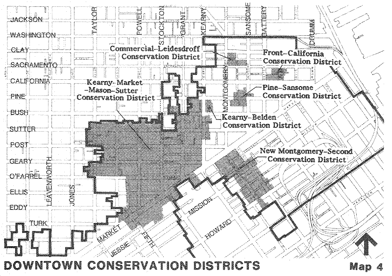
- Create conservation districts in areas with special characteristics and qualities.
Certain sections of downtown have concentrations of buildings that together create geographic areas of unique quality. In these areas, buildings of a somewhat lesser quality than those required to be retained take on an increased importance. These buildings help create a setting that reinforces and complements the qualities of the more significant structures in the area and their own attributes are more apparent and appreciated.
Areas containing these concentrations of significant and contributory buildings would be designated as conservation districts to facilitate preservation of the quality and character of the area as a whole.
In these districts, demolition and alteration of significant buildings would be subject to the restrictions applicable to those buildings described above. Contributory buildings as well as unrated buildings could be altered or replaced by new development. However, alterations or new development would be reviewed to assure maintenance of the character of the district. Both significant and contributory buildings would have transferable development rights.
Key Implementing Action
- Allow transfer of the unused development rights from Significant and Contributory Buildings.
Both significant and contributory buildings should be entitled to sell for use on another site "transferable development rights", that is, the difference between the actual square footage of the building to be retained and the square footage of a new building that could be built on the lot as determined by the applicable floor area ratio. These "transferable development rights" (TDR) could be transferred to any parcel or parcels within the same zoning district if the height, bulk, and other rules of this Plan would permit the increased square footage. TDRs from the retail and office districts and to a more limited extent from the general commercial and support districts could also be used in a special development district immediately south of the existing C-3-O district or, if the transfer is from the Yerba Buena Center Redevelopment Project Area, to the existing C-3-O district, where increased densities are appropriate. Since the square footage is simply transferred from one lot for use on another, the total allowable density downtown would not be increased.
TDRs are proposed as a planning tool to insure the maintenance of sufficient development potential in the C-3 District to accommodate orderly growth and preserve a compact downtown, and to balance the public and private interests affected by the preservation policies. TDRs are not legally necessary to compensate property owners for restricting development of sites of landmarks and significant building sites. Similar restrictions on demolition of landmarks, without TDR, have been sustained by courts in many parts of the country.
Urban Form
Background
The urban form chapter includes objectives, policies and actions governing downtown building height and bulk, separation of buildings, sunlight access, wind protection, building appearance, and the relationship of buildings to the street.
Height and Bulk
OBJECTIVE 13
CREATE AN URBAN FORM FOR DOWNTOWN THAT ENHANCES SAN FRANCISCO'S STATURE AS ONE OF THE WORLD'S MOST VISUALLY ATTRACTIVE CITIES.
The visual appeal of San Francisco is based on its topography — its hills and ridges and their relationship to the ocean and bay — and on the scale of existing development. This scale is by and large a light-toned texture of separate shapes blended and articulated over the city's topography.
Fitting new development into this environment is, in a broad sense, a matter of scale. It requires a careful assessment of each building site, relating a potential new structure to the size and texture of its surroundings. It means making a very conscious effort to achieve balance and compatibility in the design for the new building. Good scale depends upon a height that is consistent with the total pattern of the land and of the skyline, a bulk that is not overwhelming, and an overall appearance that is complementary to the building forms and other elements of the city. Since the height, bulk and appearance of past development differs within the city, scale is relative. Historically, the buildings forming San Francisco's skyline and streetscape were harmonized by color, shape, and details. Much effort was made in the past to relate each new building to its neighbors at both upper and lower levels, and to avoid jarring contrasts that would upset the city pattern. Special care was accorded the edges of distinct districts, where transitions in scale are especially important. Similar effort and care must be taken with new development in the future.
Tall buildings are a necessary and expressive form for much of the city's office, apartment, hotel and institutional development. These buildings, as soaring towers n an otherwise light-colored, low-rise city, evidence the city's economic strength. They make economical use of land, offer fine views to their occupants, and permit efficient deployment of public services. If properly placed, tall buildings enhance the topographic form and existing skyline of the city.
A proper plan for building height should weigh all the advantages and disadvantages of height at each location in the city. It should also take into account appropriate, established patterns of building height and scale, seeking for the most part to follow and reinforce those patterns. The plan should recognize the functional and economic needs for space in major centers for offices, high density apartments, and hotels.
Bulk refers to the apparent massiveness of a building compared to its surroundings. A building may appear to have great bulk whether or not it is of extraordinary height. It can block near and distant views and create a disconcerting dominance on the skyline and neighborhood. Users of modern building space may find these bulky forms more efficient, or more logical for combining several uses in a single development. But, these considerations do not measure the external effects upon the city.
The apparent bulk of a building depends primarily upon two factors: the amount of wall surface visible, and how far the structure extends above its surroundings. Accordingly, a plan seeking to avoid excessive bulkiness should consider the existing scale of development in each part of the city and the effects of topography in exposing building sites to widespread view.
In general, the texture of San Francisco, when viewed from close-up or from afar, is one of small-scale buildings covering the hills on a grid street pattern, punctuated by green space and occasional larger significant structures, such as churches, schools, and hospitals. The collective mass of office buildings in the Financial District has become the most prominent man-made component of the skyline. The bridges, Twin Peaks, and Golden Gate Park, remain distinctive and identifiable, but increasingly, the intense cluster of large-scale structures is the city's dominant image. The bulkiness and repetitive boxiness of many recent structures have obscured the fine-scale sculptured skyline of pre-World War II San Francisco. To create a new sculptured skyline, new buildings must have generally thinner and more complex shapes.
Control of building bulk limits the impact of building mass. At the streetscape — the closest view — building mass directly affects the light and air on the street, on plazas, and on adjacent buildings. The mass of an individual building dominates the scene from a pedestrian's view.
Views down a street or from upper floors of buildings across the downtown enable the mass and shape of buildings to be compared with one another. Here relationships of building forms to other building forms become important. An excessively bulky building can obscure views to and from other buildings.
At a distance of a mile or more, relationships among buildings form a skyline image — a combined mass and shape. The bulk and form of the individual structures — most particularly the taller, larger structures and those at the edge of downtown — affect the skyline image. Bulk controls should address the impact of a building at the streetscape view, its relationship to neighboring buildings, and its cumulative impact on the skyline as a whole. Controls should provide a building envelope that offers a latitude for individual building design, but in harmony with the whole.
POLICY 13.1
Relate the height of buildings to important attributes of the city pattern and to the height and character of existing and proposed development. (See Map 5)
Downtown height controls should be consciously structured and varied to create specific areas which simulate the natural hills that characterize San Francisco. Taller buildings should be clustered to promote the efficiency of commerce and avoid unnecessary encroachment upon other areas. The downtown financial core — the major place of tall buildings in the city — should be kept separate from other less intense activity areas in surrounding low rise development. It should taper down to the shoreline of the Bay. Other highrise nodes should be kept away from the base or sides of hills as far as possible, or should be restrained from further intrusion onto hillsides.
In previous eras of city building, the height of new development within an area might be expected to vary considerably. The pressure to maximize development on a site was not as significant a factor then. Under such conditions, extended areas with the same height limit did not pose any city form problems. A natural variety of heights resulted in a complex, interesting city form.
There is now, however, an increasing tendency to build to the height limit, particularly in height districts lower than 400 feet. When many buildings are constructed at the height limits, a visible lining up of building tops occurs. This phenomenon called benching causes an awkward city form.
To avoid this benching effect, narrower height districts of varied height and mechanisms which allow greater height for more slender buildings should be created. Height limits should be structured so as to allow the presence of new buildings to affect the existing skyline in a positive way, softening existing "benching," and providing more variety and interest in the skyline and general view of the city.
POLICY 13.2
Foster sculpturing of building form to create less overpowering buildings and more interesting building tops, particularly the tops of towers. (See Figures 2 and 3)
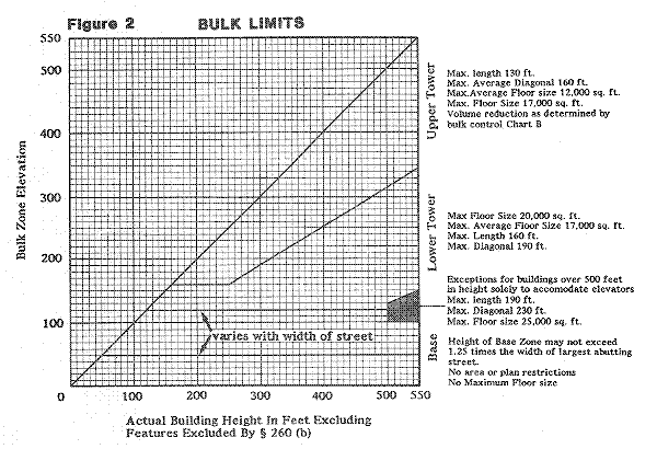
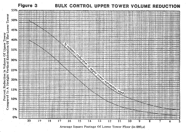
As buildings increase in height, they should be sculptured or shaped to appear increasingly slender and delicate. Modifying the silhouette of a building, making the more visible upper portion slender, offsets the building's bulkiness.
The shape given to the top portion of every large structure should consider the building's position in city views. Prominent buildings should be consciously designed to contribute to a graceful skyline in harmony with the texture of development on surrounding hills. Buildings below the city silhouette, but still prominent in views, should contribute to an overall sculptural form — avoiding awkward or overscaled blunt forms. The tops of all buildings should be interesting to look at from nearby towers.
Skyline effects of existing box-shaped buildings should be masked or softened by new tall, well-composed buildings similar in height to nearby towers should be shaped and detailed to disguise the similarity.
POLICY 13.3
Create visually interesting terminations to building towers.
All buildings should be massed or otherwise designed or articulated to create a visually distinctive termination of the building facade. The intent is to return to the complex visual imagery of the surrounding hillsides and to the complex architectural qualities of older San Francisco buildings. However this does not mean that literal employment of historical detailing is encouraged, although that may be called for in particular circumstances. What is desired is the evolution of a San Francisco imagery that departs from the austere, flat top box — a facade cut off in space.
POLICY 13.4
Maintain separation between buildings to preserve light and air and prevent excessive bulk. (See Figure 4)
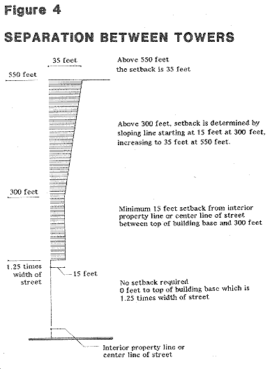
Every major highrise should be designed to be a good neighbor to surrounding towers, recognizing that a potential exists to build additional structures in the immediate vicinity. Setbacks on interior property lines and setbacks on narrow south of Market streets, should be provided to assure adequate separation between towers even though the structures are on relatively small lots.
POLICY 13.5
Create an elegant downtown skyline by crafting a distinct downtown hill form with the city's tallest building - the Transbay Transit Tower - rising as its "crown."
As the geographic epicenter of downtown and the front door of the Transbay Transit Center, the Transit Tower should be the tallest building on the city's skyline. The Tower represents the City's commitment to focusing growth around a sustainable transportation hub, as well as the apex of the downtown skyline. See the Transit Center District Sub-Area Plan for Further discussion.
Sunlight and Wind
Background
The existing land use controls give little attention to the effect of building form on the loss of sunlight and the creation of wind. The shadow and wind studies done as part of the elaborate environmental review process initiated after existing controls were adopted, along with the special analysis of wind and sun which has been undertaken recently have heightened public concern over these issues. The blockage of sunlight to St. Mary's Square caused by the Telephone Building on Pine Street and the wind currents around Fox Plaza, the Federal Building, and the U.S. Assessor's Building are dramatic examples of the impact of inappropriate building forms on the pedestrian environment.
Pedestrian comfort depends on the combined effects of sun, wind, temperature, and humidity. Locations exposed to the wind and shaded by buildings are seldom comfortable in San Francisco's typically cool temperatures.
OBJECTIVE 14
CREATE AND MAINTAIN A COMFORTABLE PEDESTRIAN ENVIRONMENT.
POLICY 14.1
Promote building forms that will maximize the sun access to open spaces and other public areas.
Given San Francisco's temperate climate, the warmth provided by direct sunlight can make a significant difference in the physical comfort experienced in these spaces.
Buildings to the south, east, and west of parks and plazas should be limited in height or effectively oriented so as not to prevent the penetration of sunlight to such parks and plazas.
In addition to parks and plazas there are certain locations in the downtown where direct sunlight is very important. They include shopping streets in the retail district, and alleys with a high concentration of eating and drinking establishments and a high volume of lunchtime pedestrian use.
New buildings adjacent to these spaces should be shaped to minimize the shadow that is cast by the building on the public space.
POLICY 14.2
Promote building forms that will minimize the creation of surface winds near the base of buildings.
Variation in ground level wind impacts is related to several factors:
Exposure of the building to the prevailing wind direction, the more exposed a building is, the greater the volume and momentum of the wind intercepted, and the greater the potential for wind accelerations at street level.
The shape, area and uniformity of the upwind facade. Relatively large, uniform facades typically result in greater wind accelerations than do narrow or complex facades with numerous setbacks.
These factors should be taken into account in the massing and detailing of new buildings. Exposed facades should use setbacks at various levels, and other configured shapes and design features, to reduce wind impact. In buildings of a size likely to cause problems, wind tunnel tests of alternative building masses should be undertaken and the results employed in selecting the shape of the building. As a general rule, a building form should not be used which causes wind speeds to exceed eleven miles per hour in areas where people are walking and seven miles per hour where people are sitting.
Building Appearance
OBJECTIVE 15
CREATE A BUILDING FORM THAT IS VISUALLY INTERESTING AND HARMONIZES WITH SURROUNDING BUILDINGS.
POLICY15.1
Ensure that new facades relate harmoniously with nearby facade patterns.
When designing the facade pattern for new buildings,the pattern of large nearby existing facades should be considered toavoid unpleasant juxtapositions. Incongruous materials, proportions,and sense of mass should be avoided.
As a general rule, facades composed of both vertical and horizontal elements fit better with older as well as most new facades.
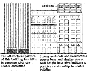
POLICY 15.2
Assure that new buildings contribute to the visual unity of the city.
For the most part, buildings in San Francisco are light in tone. The overall effect, particularly under certain light conditions, is that of a whole city spread over the hills. To maintain continuity with this existing pattern, disharmonious colors or building materials should be avoided. Buildings should be light in color. Highly reflective materials, particularly mirrored or highly reflective glass, should be used sparingly.
POLICY 15.3
Encourage more variation in building facades and greater harmony with older buildings through use of architectural embellishments and bay or recessed windows.
Streetscape
OBJECTIVE 16
CREATE AND MAINTAIN ATTRACTIVE, INTERESTING URBAN STREETSCAPES
POLICY 16.1
Conserve the traditional street to building relationship that characterizes downtown San Francisco.
San Francisco is noted for streets that are at the property line with little or no space between them. This historical pattern of development gives San Francisco its intense urban quality.
This pattern should be preserved and fostered. Structures generally should be built to the street property line along the entire frontage to a sufficient height for proper definition of street space. Exceptions to this streetwall should be allowed to create open space and circulation space where desirable and appropriate. However, open spaces should not be so frequent or close together that they undermine the sense of a continuous streetwall.
POLICY 16.2
Provide setbacks above a building base to maintain the continuity of the predominant streetwalls along the street.
Many downtown streets contain ornate older buildings of modest scale, which should be preserved for future generations to appreciate. While the heights of these buildings vary when taken together, they often create a sense of a unitary street facade or wall. This street wall gives continuity and unity to the streetscape. The intrusion of large, flat planed modern buildings among small-scaled and decorated older buildings can break up the continuity and unity.
If the new taller building is set back an appropriate distance above the existing predominant streetwall height, the upper portion of the building will not be perceived as part of the streetwall, and if the lower portion were given a similar texture and projecting cornice the disruption would be minimized. The depth of the setback required would be a function of the width of the street and the height of the existing streetwall.
The height of the streetwall cannot be determined with great precision by a mathematical formula. Often there is considerable variation in the heights of buildings on the same block. Determination of an appropriate streetwall height for the new building is a question of judgment — "What height would be consistent with the general scale of the buildings on the block that are likely to remain?" This question would be resolved in a case-by-case basis.
In areas where there is no pre-existing streetwall worth of retention, setbacks may not always be needed if a strong, pedestrian scaled building base is crated and the building tower is well separated from other towers. However, setbacks might still be needed for sunlight access or to create windbreak.
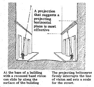
POLICY 16.3
Maintain and enhance the traditional downtown street pattern of projecting cornices on smaller buildings and projecting belt courses of taller buildings.
The projecting cornice is a very distinctive San Francisco architectural feature. Most older buildings have them. Most tall older buildings also have horizontal architectural features that clearly define the building base at a level typically half to one times the width of the street. These projections, together with the generous use of decorative embellishments, contribute to the architectural sense and comfortable human scale of downtown San Francisco. Their contemporary use should be encouraged in new development. Alternative means of terminating the shorter building or defining the base of a taller one could be employed if effective in creating a sense of street scale. However, it is extremely difficult to do this unless one's eye is interrupted by a projection as it moves up the facade from the base. Change of color, colored bands, and grooves are generally ineffectual and rely on the projections on adjacent buildings for what effect they do have.
POLICY 16.4
Use designs and materials and include activities at the ground floor to create pedestrian interest.
Retail Uses
Shops and restaurants contribute liveliness and visual interest to street frontages, lobbies and plazas of office buildings. Group floor space fronting on streets, pedestrianways, plazas, and courtyards outside the retail district should be devoted primarily to retail and service uses that are of interest to pedestrians and that meet the needs of workers and visitors to nearby buildings.
Glass
The use of clear untinted glass on the first two or three floors of buildings permitting pedestrians to glimpse the activity within, contributing to the overall sense of liveliness of the street. Dark tinted windows create a blank impersonal street front with no sense of life or activity, and should be discouraged.
Detailed Bases
Incorporation of visually interesting details and/or decoration into the design of the base avoids an excessively dull frontage.
Decorative features, including the detailing found on many older and some contemporary designs, assure needed visual interest for the pedestrian. They should be used whenever practical.
Textured Blank Walls
When blank walls are unavoidable, they should be made less oppressive through the interesting patterns and scale-giving feature.
POLICY 16.5
Encourage the incorporation of publicly visible art works in new private development and in various public spaces downtown.
The quality of life is enriched by art and artistic expression in many varied forms. The worker or visitor to downtown spends many hours in an environment of office buildings and commercial enterprises. Art in this environment can offer a counterpoint, attract the eye, stimulate the imagination, arouse emotions or just cause a momentary interest or amusement.
In the past, many prominent buildings included sculptured relief, ornate custom grillwork, mosaics, murals, carvings, as well as statuary and other forms of artistic embellishment. Buildings were less separable from art and artistic expression.
To reestablish this tradition of enhancing the environment for all to enjoy, artwork should be incorporated in new buildings and public spaces in downtown. Art work is required for all new public buildings of the City and County. The Redevelopment Agency has successfully used a requirement for art work in its downtown redevelopment projects to obtain major fountains, sculpture, and other artworks which have made a substantial contribution to the quality of the downtown environment.
Sculpture, bas-relief, mosaics, murals, and decorative water features are among the types of artwork that should be provided.
Moving About
Background
Even in the days when San Francisco was a port and fishing village, access to downtown was critical in generating and accommodating growth in the city. Located at the upper end of a 40-mile peninsula, the city grew almost exclusively on the support of a waterborne transportation system.
Ferries provided the links to Marin, and the East Bay, and up the Delta to early rail connections inland. In time, this regional ferry network became quite extensive and moved 37 million persons a year into and out of downtown. The ferry boats were met by electric railroad transit systems, including a third-rail electric commuter railway from Sausalito north to San Rafael. A similar overhead-wire electric inter-urban system in the East Bay connected directly to Emeryville, Berkeley, Oakland, Alameda, and places as far as Chico. These systems were supported by miles of electric streetcar and cab car systems. The focus of all these networks at one point—downtown San Francisco—made it the most accessible by land and water in the Bay Area.
Thus established, downtown San Francisco continued to grow. To make growth possible, the transportation systems were altered and expanded over successive decades. The Bay Bridge was opened in 1936, and the Golden Gate Bridge a year later. These two connections provided direct access for trains and automobiles and spelled the decline and virtual elimination of ferry boats.
During World War II, the transportation system was taxed to its maximum capacity. Very little additional expansion of the basic networks occurred. Following the war, several dramatic changes took place. The San Francisco Municipal Railway (MUNI) absorbed the Market Street Railway, its larger, privately owned competitor, as well as most of the independent cable car operators. Fifteen years of deferred maintenance had taken its toll on streetcar and cable car lines. These were replaced by trolley buses and motor buses. Freeways were planned and construction begun. Interurban rail tracks were removed in 1958 from the lower deck of the Bay Bridge to increase capacity. The State enacted a law for toll bridge payment of an underwater rail subway tube if any regional transit system was ever constructed. Early proposals for subways under Market Street date back to the 1920s, but it wasn't until 1962 that the three-county Bay Area Rapid Transit District (BART) was approved by the voters.
By the time BART's transbay revenue trains once again provided direct passenger rail links to the East Bay in 1974, the city had already experienced the "freeway revolt." The freeway system had been stopped. The second bridge across the Bay was voted down. The Embarcadero Freeway had been recommended for removal. The completion of I-280 to the Bay Bridge had been deleted from the Interstate Highway System. The planned system of grade-separated roadways had been only partially constructed.
The City Planning Commission and Board of Supervisors adopted a "transit first" transportation policy in 1973. The fragile environment of San Francisco was too important to be dismantled and disrupted by the scale of infrastructure required to support an "automobile first" policy. The city's Master Plan called for accommodating future growth downtown with public transit.
In the ten years since adoption, the "transit first" policy has worked well. Millions of square feet of office space, hotels, and retail have been constructed, and thousands of additional person work downtown. There has been no significant increase in automobile infrastructure. The downtown streets have been strained, but remain serviceable because of the success of the transit first policy.
The city's policy has worked because the years since 1972 have included opening BART, creation of the Golden Gate Transit erry and bus system to the North Bay counties, creation of SamTrans to acquire and expand former Greyhound service to San Mateo County, opening of MUNI Metro as a light-rail urban subway system serving one-quarter of the city's neighborhoods, and federally assisted expansion of bus service throughout the region. Recently, the responsibility for operating the Southern Pacific (SP) commuter service was assumed by Caltrans. Plans are under way to expand and possibly extend this service closer to downtown. Taken together, the last ten years have brought a significant addition to transit access to downtown San Francisco.
Downtown employment may grow by as much as 90,000 jobs by the year 2000. Conditions would deteriorate significantly if employment growth results in many more cars downtown. For this reason, the Downtown Plan does not recommend expanding the capacity of streets and bridges to accommodate an increase in the number of cars entering the general downtown area during the peak period. Nor does it advocate lengthening the peak period to more than two hours to accommodate more commuters. This is already happening and it could be encouraged by promoting staggered work hours. However, extending the peak would require an expansion of the parking supply and will increase street congestion and further restrict regional mobility. The Plan, therefore, contemplates another strategy with two principal efforts.
Effort 1: Increase the number of commuters per vehicle
Ridesharing should be expanded. The increase in average auto occupancy rates shown in Table 2 might be achievable through increased use of carpools and vanpools and these increases should be established as a planning goal.
The extent to which increases in ridesharing can be achieved is primarily dependent upon the incentives provided to carpoolers/vanpoolers. Feasible increases vary from corridor to corridor because of the differences in ridesharing incentives that can be provided.
The coordination of ridesharing activities, (such as is being performed by RIDES for Bay Area Commuters and transportation brokers) and low cost, reserved parking spaces for vanpools (as is being provided in various Caltrans lots underneath the freeways) are available to commuters from all corridors. Other incentives are quite different from corridor to corridor. The East Bay corridor has three toll free high occupancy vehicles (HOV) lanes at the approach to and the metering area beyond the Bridge toll plaza. Returning commuters have an exclusive HOV lane and on ramp to the Bay Bridge via Bryant and Sterling Streets. The North Bay corridor has a HOV lane on U.S. 101 from Greenbrae to Richardson Bay Bridge and has free tolls to HOVs but no exclusive by-pass lanes. The South Bay corridor has a HOV lane on I-280 southbound between Sixth Street and just north of the U.S. 101 interchange. As commute times are extended because of congestion these ridesharing incentives will become stronger.
There are no incentives currently provided to San Francisco commuters on freeways (except the HOV lane on southbound I-280) and surface streets. In the short term it is expected that the difficulty and expense of parking will be the primary incentive for ridesharing by San Francisco commuters.
Table 2: Ride Sharing
| (COMMUTER OCCUPANCY RATE PER VEHICLE) | |||
|---|---|---|---|
| Corridor | Existing | Year 200 Goal | Percentage Increase |
| East Bay | 2.42 | 2.83 | 16% |
| North Bay | 1.47 | 1.68 | 14% |
| Peninsula | 1.76 | 1.94 | 10% |
| San Francisco | 1.24 | 1.36 | 9% |
| All Coridors | 1.48 | 1.66 | 12% |
If these increases can be achieved it would mean an additional 12,000 people could travel by automobile from the three regional corridors without increasing the number of automobiles.
Effort 2: Increasing the number and percentage of commuters using transit
By increasing the percentage of downtown commuters using transit to 70% from the existing 64% as shown in Table 3 (and assuming the ridesharing goals can be met) the projected additional workers can be accommodated without increasing the total number of commuter vehicles. This percentage increase should be established as a planning goal.
This goal could be achieved with the following additions to transit capacity and other measures: (1) projects in the vehicle acquisition plans of the transit operators current 5-year plans and capacity increases for MUNI, Golden Gate, SamTrans and A/C of from 2% to 2.5% per year beyond current 5-year plans to 2000; (2) construct a MUNI-Metro Turnaround at Embarcadero; (3) purchase additional cars to make BART Transbay trains all 10-cars during peak period; (4) extend MUNI-Metro to 4th and Townsend Streets; and (5) an effective implementation and enforcement program for transit preferential treatments on downtown streets.
These two goals — increasing the percentage of workers commuting downtown by transit in the two-hour peak from 64% to 70% and increasing the occupancy rate for persons per vehicle to 1.66 persons per vehicle — are formidable goals. But they must be achieved if the project rate of employment growth is to be manageable.
Table 3: Change in Use of Auto and Transit for Commute Trips
| AUTOMOBILE | TRANSIT | |||
|---|---|---|---|---|
| Year | Persons | Percent | Persons | Percent |
| 1984 | 68,400 | 36% | 116,600 | 64% |
| 2000 | 76,900 | 30% | 179,400 | 70% |
The Plan describes a number of implementing actions in order to carry out Effort I to increase ridesharing and Effort II to increase transit ridership. These implementing actions, while not all are required to accommodate forecasted downtown growth would make a contribution to overall transportation efficiency and reduce congestion from current levels. To the extent various actions are carried out, commuters, shoppers and visitors in the year 2000 will experience less congestion, more comfort, less pollution, and fewer inconveniences in moving to, from and through downtown than they do today.
Moving to and From Downtown
OBJECTIVE 17
DEVELOP TRANSIT AS THE PRIMARY MODE OF TRAVEL TO AND FROM DOWNTOWN.
The automobile cannot serve as the primary means of travel to and from downtown. An alternative means--convenient and of greater efficientcy--is required. Good, direct transit service is available from almost all parts of the city to downtown. Transit is the dominant means of travel during the rush hours. Nevertheless, travel is often slow, and vehicles are crowded during the rush hours.
Crowding can never be eliminated completely. However, it is important for continued patronage and rider comfort that trunklines serving outlying districts provide seats for all passengers and that short-term standing riders be allotted adequate space. Travel to downtown should be possible in less than 30 minutes from all parts of the city. It can be achieved with express buses, exclusive bus lanes, and construction of rapid transit lines.
The use of transit for travel from the suburbs to downtown can only become the primary travel mode over the long run with the extension of a good regional transit system connecting downtown to other parts of the Bay Area.
POLICY 17.1
Build and maintain rapid transit lines from downtown to all suburban corridors and major centers of activity in San Francisco.
The city and much of the region should continue its commitment to a transit first policy with respect to intercity commuter travel. Rapid rail transit probably offers the most competitive service in relation to automobile travel. It also offers the highest possible capacities in transit service. The use of BART or any other line-haul rail system is dependent to a great extent on access to and from stations in outlying residential areas and employment centers. Well-planned suburban feeder systems should be provided.
Non-rail Transit
POLICY 17.2
Expand existing non-rail transit service to downtown.
Given the capacity of roads and bridges leading to and from downtown, which are not likely to be expanded significantly, the projected growth in downtown employment can only be accommodated by expanding the peak commute period and expanding the use of carpooling and/or expanding transit service to and from downtown. Until rail transit is available, non-rail transit service, particularly from the East Bay and from within San Francisco, should be increased. Various carriers serving downtown should develop long-range service expansion plans to accommodate the projected demand generated by downtown San Francisco growth.
Transit Lanes
POLICY 17.3
Establish exclusive transit lanes on bridges, freeways and city streets where significant transit service exists.
Transit lines should provide more efficient service by operating on their own rights-of-way. These should be instituted on bridges, freeways and thoroughfares leading into the city, such as on the Waldo Grade and Golden Gate Bridge, and interconnect, where feasible, with a system of exclusive bus lanes or other transit-priority street segments in the city.
Transit Transfers
POLICY 17.4
Coordinate regional and local transportation systems and provide for interline transit transfers.
To increase the usefulness and convenience of transit systems, transit users should be able to transfer freely from one system to another. The points of interchange should be clearly identified. The creation of new fare recording mechanisms based on a magnetically encoded card, such as the "Fast Pass" or BART ticket, would expand interline travel.
Free, or low cost transfer should be available between MUNI and each of the suburban transit opertors. Suburban residents often require MUNI service to extend their trips within San Francisco.
Transit Terminals
POLICY 17.5
Provide for commuter bus loading at off-street terminals and at special curbside loading areas at non-congested locations.
Off-street terminals are preferable to curbside locations because they provide adequate back-up space for passenger waiting, ticketing and loading. They also provide convenient transfers among different systems. On the other hand, loading and unloading points should be conveniently distributed throughout downtown to make transit attractive to intercity commuters. As opportunities present themselves off-street terminals should be developed. Until adequate terminals can be provided, commuter buses should load and unload at designated and easily identifiable curbside locations such as Market Street. They should be chosen to minimize conflict with pedestrian flows.
POLICY 17.6
Make convenient transfers possible by establishing common or closely located terminals for local and regional transit systems.
One or two new terminals should be developed, or an existing one upgraded, to accommodate buses and rail services provided by various regional and local lines. The terminals should be in close proximity to, or fully integrated with, BART stations and MUNI terminals to make transfers between lines possible by a short walk. Priority should be given to a location or locations where existing and future intensities of development are highest.
Ferries
POLICY 17.7
Continue ferries and other forms of water-based transportation as an alternative method of travel between San Francisco and the other communities along the Bay, and between points along the waterfront within San Francisco.
For communities in Marin County, ferry or high-speed water craft offers an alternative means of travel to downtown. It offers an efficient and pleasant way to commute and should be continued. As ridership and location warrant, water-based transportation should be developed to other locations in the Bay Area.
OBJECTIVE 18
ENSURE THAT THE NUMBER OF AUTO TRIPS TO AND FROM DOWNTOWN WILL NOT BE DETRIMENTAL TO THE GROWTH OR AMENITY OF DOWNTOWN.
Increasing automobile traffic means more environmental damage and greater inconvenience. A basic premise of the Transportation Element of the Master Plan is that a desirable living and working environment and a prosperous business environment cannot be maintained if traffic levels continue to increase without limits. Various methods should be used to control and reshape the effect of automobiles on the city, and to promote other means of transportation to improve the environment.
POLICY 18.1
Do not increase (and where possible reduce) the existing automobile capacity of the bridges, highways and freeways entering the city.
The established policy of limiting access into and through the city by automobiles should be maintained. This policy works in conjunction with policies calling for increasing transit for commuters to San Francisco. More vehicular access into the city conflicts with environmental objectives, overloads the city street system, and jeopardizes the city's commitment to mass transit. This policy allows for the introduction of exclusive bus lanes on bridges, highways, and freeways where these lanes are compatible with transit systems and where they will help provide better service.
Carpools-Vanpools
POLICY 18.2
Provide incentives for the use of transit, carpools and vanpools, and reduce the need for new or expanded automobile parking facilities.
The alternatives to expanding automobile facilities are to make existing faciliies serve more people and to use other ways of getting people where they want to go. Single-occupancy automobile use is incompatible with the need to conserve energy and land, the need to reduce congestion on thoroughfares, and the need to reduce auto emissions.
Actions that make transit more convenient, economical and reliable should remain a high priority for San Francisco. Carpooling should be encouraged for those work trips which cannot be made conveniently by transit.
Employers should be encouraged to provide incentives for transit use and carpooling by employees. A transit subsidy, such as the provision of a transit "fast-pass," could be an alternative to the provision of free employee parking. Where an employer already has parking spaces available for employees, these spaces should be reserved for those persons who carpool.
Commuter Parking
POLICY 18.3
Discourage new long-term commuter parking spaces in and around downtown. Limit long-term parking spaces serving downtown to the number that already exists.
A basic premise of this Plan is that additions to the commuter load brought about by job growth should not be accommodated by additional automobiles. Bringing more autos to downtown would only add to the congestion which already is approaching unacceptable levels in some parts of downtown. More autos would also add to air pollution. New long-term public parking facilities should be limited to those needed to replace parking eliminated in the downtown core. However, although it is preferable that all replacement of long-term spaces displaced in the downtown occur on the periphery, a small number of long-term spaces may be provided within new buildings in the downtown core, if, taking into account aggregate displacement of long- and short-term parking, the total number of spaces in downtown is not increased and excessive congestion in the immediate vicinity is not created. Parking entrances should not conflict with transit preferential lanes.
POLICY 18.4
Locate any new long-term parking structures in areas peripheral to downtown only if these areas are not “transit-oriented” neighborhoods. Any new peripheral parking structures should: be concentrated to make transit service efficient and convenient; be connected to transit shuttle service to downtown; provide preferred space and rates for van and car pool vehicles.
New parking should not be developed in adjacent transit-oriented neighborhoods, especially if they are well served by transit or will adversely effect the neighborhood character.
POLICY 18.5
Discourage proliferation of surface parking as an interim land use, particularly where sound residential, commercial or industrial buildings would be demolished.
Bicycles
OBJECTIVE 19
PROVIDE FOR SAFE AND CONVENIENT BICYCLE USE AS A MEANS OF TRANSPORTATION.
The number of people that choose the bicycle instead of the automobile as their main mode of transportations is steadily rising. As streets become more congested and more accommodations are made for bicyclists, many people are finding that they can move about the city more quickly, enjoyably and economically on bicycles.
POLICY 19.1
Include facilities for bicycle users in governmental, commercial, and residential developments.
Secure and conveniently located bicycle parking should be provided in newly constructed developments, regardless of the provision of auto parking. Provision should also be made for bicycle parking in conjunction with (but not solely dependent upon) automobile parking in existing and new parking lots and garages.
POLICY 19.2
Accommodate bicycles on regional transit facilities and important regional transportation links.
There should be more opportunity for cyclists to commute to San Francisco with their bikes by using regional transit modes such as BART, Caltrain, the ferry system, Golden Gate Transit, AC Transit, SamTrans, and the Caltrans Bay Bridge. All commute buses should provide carrying racks for bicycles.
POLICY 19.3
Provide adequate and secure bicycle parking at transit terminals.
Providing adequate and secure bicycle parking facilities at transit terminals is another means of promoting bicycle use by commuters. Public and private parking garages should designate otherwise unused corners or other areas for joint bicycle and motorcycle parking, particularly near high-density employment centers.
Moving Around Downtown
OBJECTIVE 20
PROVIDE FOR THE EFFICIENT, CONVENIENT AND COMFORTABLE MOVEMENT OF PEOPLE AND GOODS, TRANSIT VEHICLES AND AUTOMOBILES WITHIN THE DOWNTOWN.
The proper functioning of downtown is dependent upon compactness, strength of internal accessibility, and convenient access to downtown from other parts of the region. This section is concerned primarily with the need for proper circulation within downtown for vehicles and pedestrians, and with the organization of transit terminals and parking facilities.
The density of daytime downtown population and the resulting density of trips call for movement of people to take place in the most efficient and least space-consuming methods, such as walking and public transit. This in turn calls for controlling the automobile in the downtown area.
In addition to improvements in the pedestrian system and the pedestrian environment, every effort should be made to ensure that better transit service is provided so that transit increasingly becomes the prevailing method of travel.
Auto Circulation
POLICY 20.1
Develop the downtown core as an automobile control area.
San Francisco's downtown core is an intensely populated area functioning as the region's financial, administrative, shopping and entertainment center. Within this compact area, priority should be given to the efficient and pleasant movement of business clients, shoppers and visitors, as well as to the movement of goods. A continuing effort should be made to improve pedestrian, transit and service vehicle access and circulation. These functions must have priority use of limited street and parking space. The impact of the private commuter vehicle, in particular, and excessive automobile traffic, in general, must be reduced.
POLICY 20.2
Organize and control traffic circulation to reduce congestion in the core caused by through traffic and to channel vehicles into peripheral parking facilities.
Traffic passing through the downtown core to reach other destinations, such as North Beach, the Northwestern Waterfront, Western Addition, and South of Market, should be channeled around the downtown core. This would leave space for pedestrians and vehicles with core destinations.
POLICY 20.3
Locate drive-in, automobile-oriented, quick-stop and other auto-oriented uses on sites outside the office retail, and general commercial districts of downtown.
Drive-in establishments serving customers waiting in motor vehicles, and establishments reached primarily by automobile or providing service to automobiles, are, by definition, auto trip generators. To ensure that these uses do not aggravate an already congested pedestrian and traffic situation, they should be located away from the most intensely developed downtown areas in locations that do not create conflicts with pedestrian or auto concentrations, designated transit preferential streets or residential units.
Transit Lanes
POLICY 20.4
Improve speed of transit travel and service by giving priority to transit vehicles where conflicts with auto traffic occur, and by establishing a transit preferential streets system.
Transit speed is presently slower than auto speed due to passenger stops and street congestion. If transit speed is to be improved, conflicts btween automobiles and transit must be minimized. Substantial improvement can and should be achieved by giving priority to transit. This would be accomplished by the use of exclusive lanes (with flow or contra-flow), by constructing bus loading platforms, relocating bus stops and/or by equipping buses and trolleys with devices to trigger lights in their favor at intersections. Enforcement is a critical factor to ensure successful operation of transit lanes. Contra-flow lanes are more self-enforcing than "with-flow" lanes and should be used where appropriate. Other actions should include restricting autos from streetcar and cable car tracks and eliminating automobile turning movements that conflict with transit vehicles.
POLICY 20.5
Develop shuttle transit systems to supplement trunk lines for travel within the greater downtown area.
All parts of the downtown core are within easy walking distance of each other. However, greater downtown is large enough so that walking is not always convenient. Access should be improved with special shuttle systems similar in function to the shopper shuttle buses and cable cars. Access is particularly important between the Civic Center and the financial retail districts, and between the Hall of Justice and other areas south and north of Market Street.
Taxis
POLICY 20.6
Maintain a taxi service adequate to meet the needs of the city and to keep far as reasonable.
Taxis serve as an essential supplement to the transit system, not merely for tourists, but for many residents and workers in the city who either do not have a car or who find regular transit service inconvenient for a particular trip, of both. The elderly often rely on taxis for necessary shopping trips and for reaching medical facilities, as do many others without automobiles when transit is not available. Although taxis should continue to be regulated competition should be encouraged for improved service and low fares.
Short-Term Parking
POLICY 20.7
Encourage short-term use of existing parking spaces within and adjacent to the downtown core by converting all-day commuter parking to short-term parking in areas of high demand. Provide needed additional short-term parking structures in peripheral locations around but not within the downtown core preferably in the short term parking belt. (See Map 6)
As provided elsewhere, all day commuter parking within the downtown core is to be actively discouraged. Transit is a viable opportunity for many and parking for those who must drive should, for the most part, be provided on the fringes of downtown.
The situation is different for short-term parking. There are some shoppers, business visitors and others for whom transit is not a realistic alternative and who need parking for short periods reasonably close to their destinations. However, the amount and location of additional short term spaces allowed in the core should be carefully regulated. Short-term parking spaces attract more automobiles per day than long term spaces and do so during the midday periods when the number of traffic lanes is reduced by street parking and loading. Too much short-term parking would attract trips that otherwise would be made by transit and could add substantially to midday congestion.
Additional short term spaces in the core should be created primarily by converting existing long-term spaces to short term spaces. This could be achieved by setting high rates on all day use and not providing weekly or monthly rates. In the case of new buildings short term spaces could be provided within the building to replace long and short term spaces displaced by the new development, if excessive congestion in the immediate vicinity will not result.
Because of the congestion and coflicts with transit major new short-term parking structures are likely to create, they should be located next to major thoroughfares so that automobiles may be intercepted and uncongested movement and high internal accessibility may be provided within the core. Adequate pedestrianways should be provided for the final link of these trips.
POLICY 20.8
Make existing and new accessory parking available to the general public for evening and weekend use.
Some existing parking garages, especially those in the office buildings, are closed at night and on weekends. Instead of providing additional parking spaces at certain locations, those spaces should be made available to the general public for nighttime and weekend users. Parking garages in the Embarcadero Center are good examples.
Off-Street Loading Facilities
OBJECTIVE 21
IMPROVE FACILITIES FOR FREIGHT DELIVERIES AND BUSINESS SERVICES.
The need for adequate facilities for freight deliveries and daily services to businesses will increase as downtown grows. As a result, the conflict between the movement of customers, employees and visitors, whether on foot, by transit, or in private vehicles, will increase.
POLICY 21.1
Provide off-street facilities for freight loading and service vehicles on the site of new buildings sufficient to meet the demands generated by the intended uses. Seek opportunities to create new existing buildings.
POLICY 21.2
Discourage access to off-street freight loading and service vehicle facilities from transit preferential streets, or pedestrian-oriented streets and alleys.
Wherever possible, access to off-street loading and service vehicle facilities should be provided from nonpedestrian alleys and minor streets, rather than transit preferential streets or major arterials (see Map 6). This would minimize safety hazards and disruptions to pedestrians and traffic flow. Where several loading and service bays are provided or the number of truck trips is high, conflicts with pedestrians and vehicles should be minimized by provision of a service driveway and maneuvering area self-contained within the structures. Where the only access to on-site facilities is across a sidewalk that is heavily used by pedestrians curbside parking of freight and service vehicles may be preferable to on-site facilities.
POLICY 21.3
Encourage consolidation of freight deliveries and night-time deliveries to produce greater efficiency and reduce congestion.
Even if off-street loading facilities were adequate, there would still be conflicts between vehicles delivering goods and other vehicular and pedestrian traffic. Deliveries that must be made across the sidewalk from on-street loading spaces disrupt pedestrian movements and increase accident potential. A system of consolidating deliveries to downtown firms should be developed, with emphasis on deliveries during the late evening and early afternoon periods. Deliveries in the early afternoon when the daytime population of downtown reaches its peak should be discouraged.
POLICY 21.4
Provide limited loading spaces on street to meet the need for peak period or short-term small deliveries and essential services, and strictly enforce their use.
On-street loading and stopping spaces should continue to be required to accommodate peak period and short-term demands for small delivery vehicles and essential services. Strict enforcement to restrict these spaces to the vehicles and time limits for which they are intended is essential. In general, workers performing lengthy deliveries or repairs should be required to use off-street facilities for their vehicles.
POLICY 21.5
Require large new hotels to provide off-street passenger loading and unloading of tour buses.
Most major hotels create a large number of tour bus movements as formal sightseeing tours, group travel to airports or convention sites, or group travel under contract for airline crews. By the nature of these trips, loading and unloading times for tour buses is long and causes severe traffic problems if buses are allowed to park on downtown streets. Spaces for tour buses can be provided at adjacent curbs or in the immediate vicinity provided that they do not cause substantial adverse effects on pedestrian circulation, transit operations, or general traffic circulation.
OBJECTIVE 22
IMPLEMENT A DOWNTOWN STREETSCAPE PLAN TO IMPROVE THE DOWNTOWN PEDESTRIAN CIRCULATION SYSTEM, ESPECIALLY WITHIN THE CORE, TO PROVIDE FOR EFFICIENT, COMFORTABLE, AND SAFE MOVEMENT.
POLICY 22.1
Provide sufficient pedestrian movement space.
As outlined in the Downtown Streetscape Plan, where pedestrian volumes compared to other transportation modes so warrant, additional pedestrian capacity should be taken from traffic or parking lanes. At other locations, where appropriate, arcades or building setbacks adjacent to an existing sidewalk should be developed. In areas of highest pedestrian volumes, more parallel, through-block pedestrian ways should be provided if they can serve as convenient links among destinations without encouraging jaywalking.
POLICY 22.2
Through the development of streetscape standards and guidelines, minimize obstructions to through pedestrian movement on sidewalks in the downtown core.
Many conveniences and amenities on downtown sidewalks would be easier to enjoy if properly located to avoid conflict with pedestrian movement. Criteria for location of newspaper vending machines, flower stands, and other facilities and amenities such as trees, should consider the need for adequate space for through movement.
POLICY 22.3
Ensure convenient and safe pedestrian crossings.
As identified in the Downtown Streetscape Plan, where streets are designed for high volumes or relatively fast movement of vehicles, adequate provision should be made for safe and convenient pedestrian crossings. This is especially important where large numbers of pedestrians cross the street. These streets should have adequately-timed lights at intersections to allow safe crossings. Where large pedestrian volumes so warrant, similar provisions would be installed at midblock crosswalks. In locations where large numbers of vehicles and pedestrians coincide, grade separations might be necessary.
Where large numbers of pedestrians cross the roadway outside the intersection or midblock crosswalk, the location of the crosswalk should be realigned to coincide with the desire line, or steps taken to prevent the pattern of jaywalking.
POLICY 22.4
Create a pedestrian network in the downtown core area that includes streets devoted to or primarily oriented to pedestrian use.
Based on major pedestrian destinations and use generators, a pedestrian network should be developed to minimize conflicts between pedestrians and vehicular traffic. Such a network should include closure of streets to private automobiles and/or trucks, at least during those hours when pedestrian volumes and demand are at critical levels. Such a network should also include plazas, arcades, and open spaces required in major new developments. Land uses adjacent to major links in the pedestrian network should be of interest and utility to pedestrians.
POLICY 22.5
Improve the ambience of the pedestrian environment.
Attractive pavement, trees, containers with seasonal flowers, street lights, colorful banners and awnings should be added to the streets, as well as benches and small sitting areas where people can rest and watch the street life.
[See Pedestrian Network Classification of Elements]
[See Fundamental Principles for the Downtown Pedestrian Network]
| Base Case | Second Level | Special Level | |
|---|---|---|---|
| ATM Machines | In building setbacks or low ped. Volume streets. Not permitted adjacent to bus stops. | Building setbacks are required. Not permitted adjacent to bus stops. | Building setbacks are required. Not permitted adjacent to bus stops. |
| Awnings | Permitted if attached to the building. Canopies attached to the sidewalk are prohibited. | Awnings and canopies are permitted. Signage is not permitted | Awnings, canopies, and upper window awnings encouraged except on historic buildings without precedents. |
| Banners | Only short-term, event banners or banners attached to buildings. | Encouraged on Powell, Post, in the YBC area, and on Alleys. Elsewhere, event banners or banners attached to buildings. | All types are encouraged. On California, banners are limited to temporary installations or on buildings. |
| Benches | Not encouraged in the public right-of-way, but are encouraged in adjacent locations. | Strongly encouraged everywhere. Alternative seating areas such as window ledges and steps are also encouraged. | Strongly encouraged everywhere. Alternative seating areas are also encouraged. |
| Bicycle Racks | Only permitted if placement does not cause the Level of Service to fall to D or below. | Encouraged if placement does not cause the Level of Service to fall to D or below. | Encouraged if placement does not cause the Level of Service to fall to D or below. |
| Bollards | Only decorative bollards are permitted. | Only decorative bollards are permitted. | Only decorative bollards are permitted. |
| Vehicular Curb Cuts/Driveways | Strongly discouraged on streets with significant pedestrian volumes. | Strongly discouraged. | Strongly discouraged. |
| Flowerstands | Not encouraged. | Encouraged outside of the public right-of-way. | Strongly encourage in all locations except Montgomery Street. |
| Kiosks | Not encouraged. | Encouraged except in congested locations on Kearny, Stockton, Powell, and Fourth. | Strongly encouraged except on Montgomery. |
| Newsracks | Pedestal mounts are required in the Union Square area and strongly encouraged elsewhere. | Pedestal mounts are required in the Union Square area and on Kearney,and strongly encouraged elsewhere. | Pedestal Mounts are required. |
| Public Art in the Right-of-way | Permitted depending on pedestrian congestion. | Permitted depending on pedestrian congestion. | Strongly encouraged. On Montgomery, sidewalk placement opportunities are extremely limited. |
| Planters | Permitted in the curb zone in areas without significant pedestrian congestion. | Permitted in the curb zone, except in congested areas on Kearny, Stockton, and Powell, and in the building zone on Post. | Permitted in both the building and curb zones except on Montgomery. |
| Sidewalk Paving Treatments | Standard downtown paving pattern: Dark grey concrete, silicate carbonate, 3' scoring. | Limited decorative elements and score patterns are permitted by block face. | Distinctive decorative patterns are encouraged by block face |
| Sidewalk Cafes | Permitted on streets without significant pedestrian congestion. Encouraged on Ellis | Strongly encouraged, except on streets with significant pedestrian congestion. | Strongly encouraged except on Montgomery. |
| Sidewalk Displays | Not encouraged | Not permitted in congested areas on Kearny, Powell, Stockton, and Fourth. | Encouraged except on Montgomery. |
| Sidewalk Grade Changes | Permitted to satisfy ADA requirements | Permitted to satisfy ADA requirements | Permitted to satisfy ADA requirements |
| Sidewalk Toilets | Not permitted | Permitted at locations indicated in the design plan. | Encouraged except on Montgomery. |
| Street Artists | Permitted in the curb zone in areas without significant pedestrian congestion. | Not permitted in congested areas on Kearny and Fourth. | Strongly encouraged except on Montgomery. |
| Street Closures | Temporary, special event closures are permitted. Lunchtime c;osure is recommeded for Sansome. | Temporary closures are permitted. Lunchtime closures are recommended on Front and Destination alleys. | Temporary, special event closures are encouraged. Lunchtime closures are encouraged. |
| Streetlights | Historic streetlights are required. Pedestrian-scale lighting is strongly encouraged. | Historic streetlights are required. Building uplighting and infill pedestrian-scale lighting is encouraged | Historic streetlights are required. Building uplighting and infill pedestrian-scale lighting is encouraged |
| Trashcans | Standard downtown desitn trashcan is required. | Standard downtown desitn trashcan is required. | Standard downtown desitn trashcan is required. |
| Trees | In-ground trees are required. | In-ground trees are required. Uplighting is strongly encouraged. | In-ground trees are required. Uplighting is strongly encouraged. |
| Vendors/Street Artists | Not encouraged. | Encouraged in areas without pedestrian congestion. | Strongly encouraged except on Montgomery |
| Widenings | Permitted wherever the peak hour pedestrian LOS is C or below. | Recommended on all streets. | Recommended on all streets. |
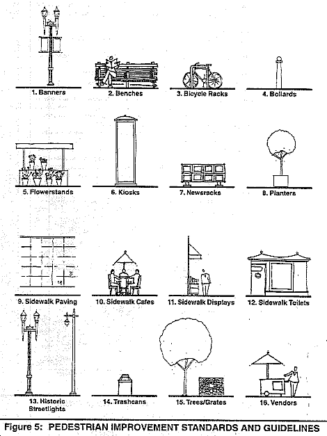
Figure 6: Proposed Downtown Pedestrian Network Improvements
Specific Streetscape Plans.
The following specific street designs are recommended in addition to the standard Base Case designs which represent the minimum level of improvements for all downtown streets:
-
Beale: See Transit Center District Sub-Area Plan.
-
Bush: Second Level Street improvements; corner bulbing at Kearny; preservation of historic teardrop lighting
-
California: Special Level Street improvements; sidewalk widening to 19' on all blocks; pedestrian signage and kiosks.
-
Cyril Magnin: Right turn on red ban at Ellis; restricted bus movements.
-
First: See Transit Center District Sub-Area Plan.
-
Folsom: See Transit Center District Sub-Area Plan.
-
Fourth: Second Level Street improvements; sidewalk widening from Market to Harrison; transit stop improvements; pedestrian signage; right turn on red ban; pedestrian safety signage; extended pedestrian crossing times.
-
Fremont: See Transit Center District Sub-Area Plan.
-
Front: Second Level Street improvements; corner bulbs at California and Sacramento; tree clusters at corners; lunchtime mall street closure.
-
Geary: Second Level Street improvements; sidewalk widening at Kearny, Stock ton, and across from Union Square; pedestrian signage and sidewalk directional elements; mid-block entrance into Union Square; transit stop improvements; hanging planters and decorative flowers facing Union Square.
-
Grant: Special Level Street improvements; corner bulbs at Post, Geary, and Sutter; distinctive paving and banners; limited traffic access; pedestrian signage and sidewalk directional elements; sidewalk public toilets; mid-block Grant Avenue Improvements crossing at Maiden Lane.
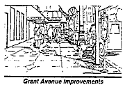
-
Howard: See Transit Center District Sub-Area Plan.
-
Kearny: Second Level Street improvements; sidewalk element restrictions; north-south corner bulbs ("snippets") at Sutter and Bush; pedestrian signage; right turn on red ban; pedestrian safety signage.
-
Main: See Transit Center District Sub-Area Plan.
-
Mason: Tourist-oriented signage.
-
Mission: See Transit Center District Sub-Area Plan.
-
Montgomery: Special Level Street improvements including distinctive paving; sidewalk element restrictions; in-ground trees; north-south corner bulbs at Sutter, Bush, Pine, and California; pedestal-mount newsracks; 1 '-2' sidewalk widening from Market to California; pedestrian signage; public art program.
-
New Montgomery: See Transit Center District Sub-Area Plan.
-
O'Farrell: Bus bulbs and transit amenities; pedestrian signage and sidewalk directional elements.
-
Post: Second Level Street improvements; distinctive "Post Street Promenade" improvements; bus bulbs at transit stops; sidewalk widening facing Union Square; pedestrian signage and sidewalk directional elements; mid-block entrance into Union' Square; hanging planters and decorative flowers facing Union Square.
-
Powell: Second Level Street improvements; sidewalk element restrictions; side-walk widening from Ellis to Geary; in-ground tree clusters; international flags/banners; pedestrian signage and sidewalk directional elements; pedestrian-scale lighting; cable car turnaround area improvements.
-
Sansome: Lunchtime street closure between Sutter and Bush.
-
Second: See Transit Center District Sub-Area Plan.
-
Spear: See Transit Center District Sub-Area Plan.
-
Steuart: Second Level Street improvements; sidewalk widening east sidewalk between Mission and Howard.
-
Stockton: Second Level Street improvements; sidewalk widening between Geary and O'Farrell; rebuild Sutter Street crossing island; pedestrian signage and sidewalk directional elements; pedestrian-scale lighting; designated street artist placements.
-
Sutter: Base Case Street improvements; bus bulbs and transit improvements.
-
Third: Second Level Street improvements; sidewalk widening between Mission and Howard; public art program including banners; pedestrian information and safety signage; right turn on red ban; signalized mid-block crossing between Mission and Howard; extended pedestrian crossing time.
-
Union Square: Rebuild crossing islands; add stop for pedestrians signage; pedestrian scramble crosswalk.
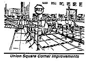
Specific Alleyway Designs
The following specific alleyway designs are recommended in addition to the standard Walkthrough Alley (Base Case) designs which represent the minimum level of improvements for all pedestrian alleys:
-
Belden: Destination Alley improvements; single-surface paving; traffic restrictions.
-
Campton: Destination Alley improvements; single-surface paving; traffic restrictions.
-
Claude: Destination Alley improvements; single-surface paving; traffic restrictions.
-
Commercial: Walkthrough Alley improvements; Destination Alley improvements between Montgomery and Sansome.
-
Ecker: Walkthrough Alley improvements; traffic restrictions; single-surface paving.
-
Leidesdorff: Walkthrough Alley improvements; Destination Alley improvements between Sacramento and Clay; traffic restrictions.
-
Maiden Lane: Destination Alley improvements; single-surface brick paving; information/historical kiosks; benches; signalized crosswalk at Grant Avenue.
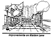
-
Garden Walks: Develop pedestrian-only mid-block garden walkways from Yerba Buena Center to Market Street, in the Terminal Separator right-of-way, and along Minna Street.
-
Natoma: Destination alley improvements. See Transit Center District Sub-Area Plan.
-
St. George: Destination Alley improvements.
-
Shaw: Pedestrian-only walkthrough alley. See Transit Center District Sub-Area Plan.
POLICY 22.6
Future decisions about street space, both in this plan and beyond, should give equal, if not greater, consideration to pedestrian needs.
The competing transportation needs present a difficult challenge for the planning of the downtown street system. Pedestrians, transit, and vehicular traffic compete for a limited amount of space downtown. Streets like Montgomery, Bush, Stockton, and Sutter are all significant vehicular traffic streets that have high volumes of pedestrians too. Often improvements to help one mode detract from the other. Scramble crosswalks in which all traffic directions are stopped and "right turn on red" bans make intersections safer for pedestrians, but can cause significant traffic congestion and transit delays. Similarly, sidewalk widenings that create more pedestrian space, can inhibit traffic movements such as curb tow-away lanes. Indeed, the Downtown Streetscape Plan does suggest a number of improvements that would hinder vehicular movement while improving the pedestrian environment. There is a recognition, though, that some of the pedestrian improvements suggested in the Plan are dramatic solutions within the continuum of street design ideas. They are offered as ideal case solutions for pedestrian needs, and some may prove impossible due to vehicular traffic demands. Prior to implementation of any project, extensive study will fully weigh the benefit to pedestrians with the impacts on transit operations, traffic movement, and parking/freight loading.
Seismic Safety
OBJECTIVE 23
REDUCE HAZARDS TO LIFE SAFETY AND MINIMIZE PROPERTY DAMAGE AND ECONOMIC DISLOCATION RESULTING FROM FUTURE EARTHQUAKES
POLICY 23.1
Apply a minimum level of acceptable risk to structures and uses of land based upon the nature of the use, importance of the use to public safety and welfare, and density of occupancy.
All risk cannot be eliminated, and reducing risks to very low levels could result in unbearably high social and economic costs to the community. Appropriate levels of risk must be established for different types of uses and buildings, as well as location of these uses. The risk must include that to both building occupants and to those outside who could be affected by exterior building damage.
POLICY 23.2
Initiate orderly abatement of hazards from existing buildings and structures, while preserving the architectural design character of important buildings.
Existing hazardous buildings pose a threat to their occupants and passers-by. The downtown area should receive priority for identification and abatement of hazards, due to its high population density. As the occurrence of earthquakes cannot be predicted, buildings with a long life span are more likely to be exposed to a major earthquake than buildings of lesser longevity. Older buildings which are proposed for retention to serve the public interest are more likely to experience such an earthquake than those on sites with a strong potential for development.
Seismic retrofitting of buildings can be very costly. Some form of public assistance may be required to ensure that retention of uses and buildings of special significance, rather than replacement, will occur. The hazards presented by older buildings are often from the architectural design elements — parapets, cornices and other ornamentation — that give them their character. Every effort should be made by the owner of the City to assure the preservation of the architectural design of the structure. This should be accomplished through reinforcing, replacing or redesigning in similar architectural style, those building elements which present a life safety hazard.
POLICY 23.3
Require geologic or soil engineering site investigation and compensating structural design based on findings for all new structures in special geologic study areas.
Much of the downtown is within a special geologic study area, which includes potential geologic hazards of severe ground shaking, liquefaction and subsidence. Increased concentration of people in this area increases the possibility of injury or loss of life. Increased development in this area should be allowed only if the determination is made that adequate safety, consistent with levels of acceptable risk, can be assured.
POLICY 23.4
Review and amend at regular intervals all relevant public codes to incorporate the most current knowledge and highest standards of seismic design, and support seismic research through appropriate actions by all public agencies.
Continued research and analysis of earthquakes and their effects upon buildings, and incorporation of the results of those efforts into code regulating the construction of buildings and structures, is essential to the public safety and welfare. This is particularly important for tall buildings with large concentrations of people. Falling glass and cladding from such buildings are particular concerns. The City's Seismic Hazards Advisory Committee should continue to provide advice to the City on the state-of-the-art in seismic safety.
Pedestrian Network Classification of Elements
Certain streets, alleys, and other rights-of-way in the downtown core area exist where varying degrees of priority should be given to pedestrian use. They have been included in the network on the basis of the following considerations: high pedestrian volumes; existing small scale street spaces; existing pedestrian-oriented features and amenities (e.g. sitting areas, planters); and public acceptance as pedestrian space.
There are five types of pedestrian streets. Their characteristics are as follows:
Base Case Streets:
The minimum standard for all downtown sidewalks. The focus is to create safe and attractive pedestrian environments that reinforce district identity. Improvements to improve mobility and render existing pedestrian space more pleasant and efficient include:
- removal of pedestrian obstructions
- relocation of newspaper vending boxes
- consolidation of signs, stanchions, etc.
- sidewalk widening/intersection bulbing
- transportation management measures to reduce automobile traffic
- special treatment of pedestrian crossing (e.g. brick crosswalks)
- turning restrictions at intersections
- relocation of transit stops
- introduction of clear zones at street corners
Base Case street furniture elements include:
- street trees
- historic street lights
- fixed newsracks
- trashcans
- standard sidewalk paving
- informational signage
Second Level Streets:
These streets are important functional and, in some cases, symbolic pedestrian streets. The Second Level Streets, Beale, Bush, Fourth, Front, Geary, Kearny, New Montgomery, Post, Powell, Second, Steuart, Stockton, and Third are designated as significant pedestrian paths between important destinations. In addition to the Base Case street features, the generally wider sidewalks on Second Level Streets (14'-15') on Second Level Streets facilitate more pedestrian amenities that might include:
- street trees with uplighting sidewalk paving variation
- benches
- bicycle racks
- sidewalk cafes
- kiosks
- sidewalk vendors
Special Level Streets:
These streets are focal-point, destination streets for the sub-districts thereby setting the tone and definition for the downtown pedestrian network. They are considered destination streets and would have corresponding wide sidewalks and street furniture. Typical designs would include Base Case and Second Level improvements with additional elements such as unique paving treatments, flowerstands and other street furniture, and sidewalk widenings. The five Special Level Streets, California, Grant, Maiden Lane, Mission, and Montgomery, are noteworthy for their citywide symbolic recognition, streetscape environment, and pedestrian function, and each merits a unique design treatment. As a rule, they should be centers of pedestrian amenities and activities with design treatments that do not appear elsewhere:
- unique streetscape
- sidewalk toilets
- decorative sidewalk paving
- upper-level awnings
- banners
- flowerstands
Walkthrough Alleys:
An alley that provides a linkage between pedestrian destinations. These destinations are usually visually connected to the alley. Building frontages tend to have smaller, historic scale with some architectural detailing. There are some service facilities as well as pedestrian-serving retail uses. Design standards for the Walkthrough Alleys, Annie, Commercial, Ecker, Jessie, Leidesdorff, Minna, Natoma, Shaw, Stevenson, and Trinity, represent the minimum level of improvements for all pedestrian alleys and include:
- removal of pedestrian obstructions
- consolidation of signs, stanchions, etc.
- newsrack restrictions
- pedestrian-oriented lighting
- traffic restrictions
- dumpster removal
- regular steam cleaning
- corner clear zones
Streetscape elements would include:
- network banners
- bollards
- street trees (space permitting)
- jnformational signage
- decorative signs on buildings
- selected sidewalk widening
Destination Alleys:
An alley that serves as an open space activity area generally located in close proximity to an area with considerable critical mass of pedestrian activity: most Destination Alleys are also Walkthrough Alleys. Building frontages tend to be small, pedestrian scale with unique historic and architectural detailing and significant glazing at street level creating a "front door" atmosphere. There are a variety of pedestrian-serving commercial uses, many of which are food services. The short length of the Destination Alley lends a sense of enclosure and distinctive "sense of place." In addition to the base case elements of the Walkthrough Alleys, design elements for the Destination Alleys, Belden, Claude, Commercial, Campton, Hunt, and St. George, would include:
- vehicle restrictions with either part-time or exclusive pedestrian use
- adjacent land uses permitted to expand into the public rights-of-way
- single surface decorative paving
- distinctive entry gate
- banners
- outdoor cafes
- vendor
- trees and planters (space permitting)
Base Case
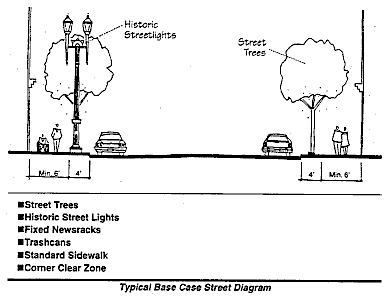
The standard Base Case Street has a 10' sidewalk as an absolute minimum, although12'-14' is preferable. The streetscape is intended to be the minimum standard for all downtown sidewalks as befitting the importance of these streets as part of the downtown urban fabric.
Second Level

The standard Second Level Street design conveys the importance of these streets and encourages both through movement and stationary activities. In addition to the Base Case features, the generally wider sidewalks (14'-15') on Second Level Streets facilitate more pedestrian amenities including benches on Front, historical accents on Second, and corner bulbing on Kearny.
Special Level
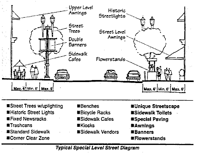
The Special Level Streets are considered destination streets and would have corresponding wide sidewalks and street furniture. California, Grant, Maiden Lane, Mission, and Montgomery all have memorable, symbolic images that are important within the downtown and for the city as a whole. Typical designs would include Base Case and Second Level improvements with additional elements such as unique paving treatments, flowerstands and other street furniture, and sidewalk widenings (to 18' to match existing sidewalks on Grant and California). However, since each street is distinctive, their designs should be distinctive too. Montgomery Street is a particular challenge since street furniture opportunities are limited due to the existing pedestrian congestion. Nevertheless, the importance of Montgomery as a pedestrian street should be recognized with some unique treatments such as decorative paving, public art, and, eventually, sidewalk widening.
Fundamental Principles for the Downtown Pedestrian Network
There are a number of general design policies that will improve pedestrian conditions throughout the downtown area. These policies include general principles as well as specific suggestions.
Pedestrian Space Policies:
-
Maintain a strong presumption against reducing pedestrian space or eliminating crosswalks to accommodate automobile traffic at the expense of pedestrians.
-
Curb tow-away lane approvals should consider pedestrian usage and level of service on fronting sidewalks. Curb tow-away lanes can be dangerous for pedestrians and are strongly discouraged on any streets on which the peak hour pedestrian level of service is D or below.
-
Street furniture should be installed in the curb street furniture zone unless otherwise noted. The size of this zone varies as illustrated in the Sidewalk Zones diagram and is dependent on the width of the sidewalk.
-
Regardless of sidewalk width or streetscape elements, a minimum of six feet (6') must be left clear at all times for pedestrian through movement. Six feet is necessary to ensure a consistent clear passage and should be exceeded wherever possible. In an area with significant pedestrian volumes, and represents the MINIMUM width; for many sidewalks downtown, more than six feet may be necessary.
-
Additional encroachments on a sidewalk are not permitted if, combined with existing encroachments, the remaining sidewalk space is less than six feet (6').
-
Regardless of sidewalk width, no sidewalk element is permitted if the placement of that element would cause the non-holiday peak pedestrian level of service to fall to level D, E, or F.
Corner and Crosswalk Policies:
-
Ensure convenient and safe pedestrian crossings. Widen sidewalks at corners where possible to provide more pedestrian queuing space and shorter crosswalk distances. Widen the crosswalk space at intersections with Pedestrian LOS D or below.
-
Crosswalk signals should be timed to provide a walk cycle which allow pedestrians a minimum ofone second of crossing time for every three and one-half feet (3.5') of the width of the street. Walk signals should be changed to clearly indicate when it is safe to start crossing, and timed accordingly. Push buttons that slow moving pedestrians could push if they need additional crossing time should be installed at dangerous or wide intersections, or in areas in which there is a high concentration of mobility-impaired pedestrians.
-
A ban on right turns during the red phase is strongly recommended for intersections with pedestrian-vehicleconflicts. Pending study, other options might include peak-hour bansor bans at specific locations.
-
Pending study of potential traffic and transit conflicts, a ban on right turns during the redphase and/or Barnes Dance signal timings are recommended on Fourth and Third at Mission, Howard, and Folsom, at the Union Square corners,on Kearny at Sutter and Bush, and on Sansome at Bush. Barnes Dance crosswalk signal timing in which all four traffic directions are simultaneously stopped allowing all pedestrians to cross both diagonally and within the crosswalks should be continued on Montgomery Street.
The corner clear zone is the minimum amount of pedestrian queuing space at the corner and is required at every corner in the downtown area. The clear zone extends a minimum of five feet (5') from the inside edge of the crosswalk and defines an area from the curb to the property line. Only items essential to vehicular and pedestrian safety and flow may remain within the clear zone. No other element may be placed within the clear zone including temporary elements.
Existing elements in the clear zone including traffic control devices, fire pull boxes, fire hydrants, and other permanent fixtures not required in the clear zone should be removedto locations outside of the clear zone when repair or replacement of those items is required and as funds become available. Other items suchas newsracks and newsstands should be moved immediately.
Pedestrian Safety Policies:
-
Increase enforcement of driving and pedestrian laws, especially at dangerous intersections. Particular attention should be focused on red light violations and illegal turning movements. Traffic Control Officers or crossing guards should be provided for heavily trafficked and dangerous intersections; TCO's should have the authority to ticket motorists for moving violations.
-
Install pedestrian safety signage at dangerous intersections. Signage should be directed at both pedestrians and drivers and be accessible to all pedestrians. Such signage might also include braille signs on the crossing signal post. An example of successful safety signage directed towards both pedestrians and drivers was recently installed at the Fourth and Howard intersection and should be considered at similar intersections.
-
Increase pedestrian awareness and education.
-
Encourage efforts to protect pedestrians from crime. Ensure an adequate distribution of emergency telephones and police call boxes Promote the installation of pedestrian-scale lighting on existing streetlights and on buildings.
-
Recessed or dark and dangerous pedestrian building areas should be well lit, including ATM's and arcades. All permits for new or remodeled outside spaces downtown should require a lighting plan to promote pedestrian safety.
-
Target dangerous intersections for pedestrian safety improvements
- Fifth/Market: Safety signage for pedestrians and vehicles. Right turn yield for pedestrians signage. Increase enforcement of right turn ban.
- Fifth/Mission: Install yield (for pedestrians) sign for right-turning traffic at the Fifth/Mission pedestrian island.
- Fourth/Market: Widen west sidewalk on Fourth Street
- Market/Kearny/Geary: Safety signage for pedestrians and vehicles.
- Stockton/Sutter: Remove curbside exclusive right turn lane, extend sidewalk at corner, and enlarge pedestrian island.
- Kearny/Sutter: Right turn on red ban; right turn yield to pedestrians signage.
- Union Square Corners: rebuild and enlarge pedestrian islands; yield sign for right-turning traffic.
-
Cyril Magnin/Ellis: Right turn on red ban; restricted bus movements.
-
Target dangerous streets for pedestrian safety improvements.
- Fourth (Market/Mission): Widen sidewalk.
- Third (Market/Mission): Install pedestrian safety signage.
- Montgomery (Post/Sutter): Widen sidewalks.
- Mission (Fourth/Fifth): Install button-activated signal for mid-block crossing.
- Fremont (Market/Mission): Pedestrian safety signage.
Sidewalk Obstacles:
-
Street signs on downtown sidewalks should be consolidated. Streetsigns on Golden Triangle streetlights are strongly discouraged and should be relocated. Double post parking signs are hazardous obstructions and should be replaced with signs on parking meter posts or with single post signs. Streetcleaning and no parking signs should be installed at 200' intervals or one per block; excess signs should be removed.
-
Single-head parking meters should be replaced with double-head meters. Parking meter alternatives should be explored including parking stations on each block that would dispense short-term parking validations to be placed on car dashboards thereby eliminating the need for individual parking meters.
-
Sidewalk elevators should only be open when in use. Advertising signage, whether temporary or permanent, attached to an open sidewalk elevator is prohibited.
-
No new sidewalk elevators, sub-sidewalk basements, or sub-sidewalk transformer vaults are permitted in the downtown area.
Street Feature Policies:
-
Preserve existing historic features such as streetlights and encourage the incorporation of such historic elements in all public and private streetscape projects.
-
Conserve and promote in-ground street trees for all downtown sidewalks.
-
Preserve and promote pedestrian-oriented building frontages on all downtown streets including all Walkthrough and Destination Alleys.
-
Encourage the installation of building up-lighting for all architecturally significant buildings.
Informational Signage:
In order to improve pedestrian orientation and movement, a signage system is recommended for the downtown area. The signage system should incorporate international symbols and languages and be accessible to all pedestrians. The signage program would have six components:
-
A series of directional signs placed at intersections and transit stops will indicate the locations of key destinations such as museums, open spaces, and districts. The directional signs might be coded with graphic symbols for major destinations and indicate proximity and direction.
-
Informational and historical plaques at key destinations would provide historical and other noteworthy information while also facilitating self-guided tours of significant sites in the downtown.
-
Directional markers placed in the sidewalk surface could be the basis for self-guided walking tours, as well as indicators of primary routes such as from the hotel district to Yerba Buena Center.
-
Maps, either free-standing or in the ground, placed at key locations (especially transit stops) in the downtown area would help to orient visitors and highlight transit, open space, and other destinations.
-
Decorative brass street labels installed in the sidewalk at every corner downtown will clearly indicate street names to pedestrians.
-
Coordinated banners at alley destinations would highlight the alleys and visually connect them to the Downtown Pedestrian Network.
Walking Tours:
-
In conjunction with the signage system, the development of self-guided walking tours is strongly encouraged. These walking tours might be oriented to historical points of interest, architecture, shopping, or tourist destinations.
Public Art:
-
Art in the public right-of-way is strongly encouraged throughout the downtown area. Art installations might range from sculptures, sidewalk inlays, and kiosk displays to performance art, dance pieces, and temporary installations.
-
Empty storefronts should be utilized for temporary art installations to enliven the streetscape.
Building Setback Policies:
-
Arcades: Due to San Francisco's mild climate and wind conditions, arcades are not always appropriate. Their primary use downtown should be to provide more sidewalk space, not as a protection against weather. Arcades might be appropriate on streets with pedestrian congestion problems such as Montgomery, Kearny, and Third. In order to facilitate pedestrian movement, arcades are required for developments on any portion of Stevenson, Jessie, Minna, Natoma, Tehama, and Clementina east of Third Street. Existing arcades should be respected; arcades should preferably be the entire block in length.
-
Window Setbacks: Space to step out of the flow of pedestrian traffic to view window contents is encouraged downtown, especially on streets with significant pedestrian volumes.
-
Corner Setbacks: Permit added pedestrian space at block corners for pedestrian queuing, often in lieu of added sidewalk space. These setbacks are encouraged.
-
ATM Machines: Queuing for ATM machines can cause severe congestion the sidewalk. ATM machines should be not be located adjacent to transit stops unless queuing space is provided outside of the public right-of-way. Elsewhere, ATM machines should be in building setbacks, where possible, or on Base Case Streets without significant pedestrian volumes. All locations require appropriately designed and placed trash receptacles.
Sunlight Access Policies:
In addition to the sunlight protections for downtown sidewalks outlined in the Planning Code, Powell, Stockton, Grant, Kearny, Ellis (north side), O'Farrell (north side), Geary (north side), Post (north side), Sutter (north side), Bush (north side Kearny/Montgomery), Front (Sacramento/Clay), New Montgomery (east side), Second (east side), and Market (north side). Additional sunlight access protection is recommended for Maiden Lane, Campton, Belden, Claude, St. George, Commercial, Minna, Front (California/Sacramento), Sansome (Market/Bush), Steuart (Mission/Howard), Third, and Fourth.
Vehicular Curb Cuts:
-
Parking Garage Entrances/Driveways: Vehicles crossing the sidewalk conflict with pedestrians. New driveways should not be permitted on Special or Second Level streets, or on any Base Case street with significant pedestrian volumes.
Typical Sidewalk Conditions:
-
Corner: The typical downtown corner should have five primary components including a trashcan, traffic/pedestrian signal device, fire hydrant, newsracks (preferably fixed), and a clear zone indicator. The clear zone indicator is a band in the concrete scoring at the corner indicating the clear zone boundaries.
-
Transit Center/Bus Stop: Well-designed bus stops in the downtown can serve multiple functions providing services for transit users as well as for other pedestrians. Standard components should include a functional shelter with sitting space, an information kiosk (either free-standing or included in the shelter), trees (6' o.c. from the curb), and, space permitting, additional seating areas. If possible, bus stops should be accommodated with sidewalk widenings allowing the creation of open space "snippets" at bus waiting areas. Otherwise, the following diagrams illustrate typical stops on a standard 15' wide sidewalk downtown.
Maintenance:
-
All streetscape improvement programs in the public and private sectors must include a capital improvement maintenance budget, and a plan for on-going upkeep. Maintenance is one of the most important factors in determining the quality of the downtown streetscape. Regular trash removal, sidewalk sweeping and steamcleaning, tree pruning, and graffiti removal are essential.
-
Property owners are responsible for the maintenance of the sidewalk area fronting their property including, but not limited to, the condition of the sidewalk surface, pruning and upkeep of privately installed trees, graffiti removal, and cleanliness of street furniture.
-
Permittee must maintain in good condition, clean and free of graffiti, all privately installed streetscape elements as per the requirements of Section 174 of the Public Works Code.
-
Regular maintenance of public streetscape elements should be a priority for all responsible city agencies. Regular cleaning and graffiti removal is recommended and all elements in disrepair should be quickly replaced.
-
All street trees should be pruned and maintained by trained professionals. The Department of Public Works, Department of Street Cleaning and Urban Forestry, is only responsible for street trees approved for maintenance. All satreet trees should include some mechanism to facilitate regular irrigation.
-
A maintenance team that could perform maintenance duties throughout the course of the day would ensure a high quality downtown streetscape while also providing entry-level employment opportunities. Private funding of these teams is strongly encouraged.
-
As important, a public safety and information service would provide a greater level of comfort and security for visitors and residents. Similar to programs in Philadelphia, Portland, and New York, public service "ambassadors" would answer questions and serve as adjuncts to regular police patrols in the downtown area.
There are a number of general design policies that will improve pedestrian conditions throughout the downtown area. These policies include general principles as well as specific suggestions.
Pedestrian Space Policies:
-
Maintain a strong presumption against reducing pedestrian space or eliminating crosswalks to accommodate automobile traffic at the expense of pedestrians.
-
Curb tow-away lane approvals should consider pedestrian usage and level of service on fronting sidewalks. Curb tow-away lanes can be dangerous for pedestrians and are strongly discouraged on any streets on which the peak hour pedestrian level of service is D or below.
-
Street furniture should be installed in the curb street furniture zone unless otherwise noted. The size of this zone varies as illustrated in the Sidewalk Zones diagram and is dependent on the width of the sidewalk.
-
Regardless of sidewalk width or streetscape elements, a minimum of six feet (6') must be left clear at all times for pedestrian through movement. Six feet is necessary to ensure a consistent clear passage and should be exceeded wherever possible. In an area with significant pedestrian volumes, and represents the MINIMUM width; for many sidewalks downtown, more than six feet may be necessary.
-
Additional encroachments on a sidewalk are not permitted if, combined with existing encroachments, the remaining sidewalk space is less than six feet (6').
-
Regardless of sidewalk width, no sidewalk element is permitted if the placement of that element would cause the non-holiday peak pedestrian level of service to fall to level D, E, or F.
Corner and Crosswalk Policies:
-
Ensure convenient and safe pedestrian crossings. Widen sidewalks at corners where possible to provide more pedestrian queuing space and shorter crosswalk distances. Widen the crosswalk space at intersections with Pedestrian LOS D or below.
-
Crosswalk signals should be timed to provide a walk cycle which allow pedestrians a minimum of one second of crossing time for every three and one-half feet (3.5') of the width of the street. Walk signals should be changed to clearly indicate when it is safe to start crossing, and timed accordingly. Push buttons that slow moving pedestrians could push if they need additional crossing time should be installed at dangerous or wide intersections, or in areas in which there is a high concentration of mobility-impaired pedestrians.
-
A ban on right turns during the red phase is strongly recommended for intersections with pedestrian-vehicle conflicts. Pending study, other options might include peak-hour bans or bans at specific locations.
-
Pending study of potential traffic and transit conflicts, a ban on right turns during the red phase and/or Barnes Dance signal timings are recommended on Fourth and Third at Mission, Howard, and Folsom, at the Union Square corners, on Kearny at Sutter and Bush, and on Sansome at Bush. Barnes Dance crosswalk signal timing in which all four traffic directions are simultaneously stopped allowing all pedestrians to cross both diagonally and within the crosswalks should be continued on Montgomery Street.
-
The corner clear zone is the minimum amount of pedestrian queuing space at the corner and is required at every corner in the downtown area. The clear zone extends a minimum of five feet (5') from the inside edge of the crosswalk and defines an area from the curb to the property line. Only items essential to vehicular and pedestrian safety and flow may remain within the clear zone. No other element may be placed within the clear zone including temporary elements.
Existing elements in the clear zone including traffic control devices, fire pull boxes, fire hydrants, and other permanent fixtures not required in the clear zone should be removed to locations outside of the clear zone when repair or replacement of those items is required and as funds become available. Other items such as newsracks and newsstands should be moved immediately.
Pedestrian Safety Policies:
-
Increase enforcement of driving and pedestrian laws, especially at dangerous intersections. Particular attention should be focused on red light violations and illegal turning movements. Traffic Control Officers or crossing guards should be provided for heavily trafficked and dangerous intersections; TCO's should have the authority to ticket motorists for moving violations.
-
Install pedestrian safety signage at dangerous intersections. Signage should be directed at both pedestrians and drivers and be accessible to all pedestrians. Such signage might also include braille signs on the crossing signal post. An example of successful safety signage directed towards both pedestrians and drivers was recently installed at the Fourth and Howard intersection and should be considered at similar intersections.
-
Increase pedestrian awareness and education.
-
Encourage efforts to protect pedestrians from crime. Ensure an adequate distribution of emergency telephones and police call boxes Promote the installation of pedestrian-scale lighting on existing streetlights and on buildings.
-
Recessed or dark and dangerous pedestrian building areas should be well lit, including ATM's and arcades. All permits for new or remodeled outside spaces downtown should require a lighting plan to promote pedestrian safety.
-
Target dangerous intersections for pedestrian safety improvements
- Fifth/Market: Safety signage for pedestrians and vehicles. Right turn yield for pedestrians signage. Increase enforcement of right turn ban.
- Fifth/Mission: Install yield (for pedestrians) sign for right-turning traffic at the Fifth/Mission pedestrian island.
- Fourth/Market: Widen west sidewalk on Fourth Street
- Market/Kearny/Geary: Safety signage for pedestrians and vehicles.
- Stockton/Sutter: Remove curbside exclusive right turn lane, extend sidewalk at corner, and enlarge pedestrian island.
- Kearny/Sutter: Right turn on red ban; right turn yield to pedestrians signage.
- Union Square Corners: rebuild and enlarge pedestrian islands; yield sign for right-turning traffic.
- Cyril Magnin/Ellis: Right turn on red ban; restricted bus movements.
-
Target dangerous streets for pedestrian safety improvements.
- Fourth (Market/Mission): Widen sidewalk.
- Third (Market/Mission): Install pedestrian safety signage.
- Montgomery (Post/Sutter): Widen sidewalks.
- Mission (Fourth/Fifth): Install button-activated signal for mid-block crossing.
- Fremont (Market/Mission): Pedestrian safety signage.
Sidewalk Obstacles:
-
Street signs on downtown sidewalks should be consolidated. Streetsigns on Golden Triangle streetlights are strongly discouraged and should be relocated. Double post parking signs are hazardous obstructions and should be replaced with signs on parking meter posts or with single post signs. Streetcleaning and no parking signs should be installed at 200' intervals or one per block; excess signs should be removed.
-
Single-head parking meters should be replaced with double-head meters. Parking meter alternatives should be explored including parking stations on each block that would dispense short-term parking validations to be placed on car dashboards thereby eliminating the need for individual parking meters.
-
Sidewalk elevators should only be open when in use. Advertising signage, whether temporary or permanent, attached to an open sidewalk elevator is prohibited.
-
No new sidewalk elevators, sub-sidewalk basements, or sub-sidewalk transformer vaults are permitted in the downtown area.
Street Feature Policies:
-
Preserve existing historic features such as streetlights and encourage the incorporation of such historic elements in all public and private streetscape projects.
-
Conserve and promote in-ground street trees for all downtown sidewalks.
-
Preserve and promote pedestrian-oriented building frontages on all downtown streets including all Walkthrough and Destination Alleys.
-
Encourage the installation of building up-lighting for all architecturally significant buildings.
Informational Signage:
In order to improve pedestrian orientation and movement, a signage system is recommended for the downtown area. The signage system should incorporate international symbols and languages and be accessible to all pedestrians. The signage program would have six components:
-
A series of directional signs placed at intersections and transit stops will indicate the locations of key destinations such as museums, open spaces, and districts. The directional signs might be coded with graphic symbols for major destinations and indicate proximity and direction.
-
Informational and historical plaques at key destinations would provide historical and other noteworthy information while also facilitating self-guided tours of significant sites in the downtown.
-
Directional markers placed in the sidewalk surface could be the basis for self-guided walking tours, as well as indicators of primary routes such as from the hotel district to Yerba Buena Center.
-
Maps, either free-standing or in the ground, placed at key locations (especially transit stops) in the downtown area would help to orient visitors and highlight transit, open space, and other destinations.
-
Decorative brass street labels installed in the sidewalk at every corner downtown will clearly indicate street names to pedestrians.
-
Coordinated banners at alley destinations would highlight the alleys and visually connect them to the Downtown Pedestrian Network.
Walking Tours:
- In conjunction with the signage system, the development of self-guided walking tours is strongly encouraged. These walking tours might be oriented to historical points of interest, architecture, shopping, or tourist destinations.
Public Art:
-
Art in the public right-of-way is strongly encouraged throughout the downtown area. Art installations might range from sculptures, sidewalk inlays, and kiosk displays to performance art, dance pieces, and temporary installations.
-
Empty storefronts should be utilized for temporary art installations to enliven the streetscape.
Building Setback Policies:
-
Arcades: Due to San Francisco's mild climate and wind conditions, arcades are not always appropriate. Their primary use downtown should be to provide more sidewalk space, not as a protection against weather. Arcades might be appropriate on streets with pedestrian congestion problems such as Montgomery, Kearny, and Third. In order to facilitate pedestrian movement, arcades are required for developments on any portion of Stevenson, Jessie, Minna, Natoma, Tehama, and Clementina east of Third Street. Existing arcades should be respected; arcades should preferably be the entire block in length.
-
Window Setbacks: Space to step out of the flow of pedestrian traffic to view window contents is encouraged downtown, especially on streets with significant pedestrian volumes.
-
Corner Setbacks: Permit added pedestrian space at block corners for pedestrian queuing, often in lieu of added sidewalk space. These setbacks are encouraged.
-
ATM Machines: Queuing for ATM machines can cause severe congestion the sidewalk. ATM machines should be not be located adjacent to transit stops unless queuing space is provided outside of the public right-of-way. Elsewhere, ATM machines should be in building setbacks, where possible, or on Base Case Streets without significant pedestrian volumes. All locations require appropriately designed and placed trash receptacles.
Sunlight Access Policies:
In addition to the sunlight protections for downtown sidewalks outlined in the Planning Code, Powell, Stockton, Grant, Kearny, Ellis (north side), O'Farrell (north side), Geary (north side), Post (north side), Sutter (north side), Bush (north side Kearny/Montgomery), Front (Sacramento/Clay), New Montgomery (east side), Second (east side), and Market (north side). Additional sunlight access protection is recommended for Maiden Lane, Campton, Belden, Claude, St. George, Commercial, Minna, Front (California/Sacramento), Sansome (Market/Bush), Steuart (Mission/Howard), Third, and Fourth.
Vehicular Curb Cuts:
-
Parking Garage Entrances/Driveways: Vehicles crossing the sidewalk conflict with pedestrians. New driveways should not be permitted on Special or Second Level streets, or on any Base Case street with significant pedestrian volumes.
Typical Sidewalk Conditions:
-
Corner: The typical downtown corner should have five primary components including a trashcan, traffic/pedestrian signal device, fire hydrant, newsracks (preferably fixed), and a clear zone indicator. The clear zone indicator is a band in the concrete scoring at the corner indicating the clear zone boundaries.
-
Transit Center/Bus Stop: Well-designed bus stops in the downtown can serve multiple functions providing services for transit users as well as for other pedestrians. Standard components should include a functional shelter with sitting space, an information kiosk (either free-standing or included in the shelter), trees (6' o.c. from the curb), and, space permitting, additional seating areas. If possible, bus stops should be accommodated with sidewalk widenings allowing the creation of open space "snippets" at bus waiting areas. Otherwise, the following diagrams illustrate typical stops on a standard 15' wide sidewalk downtown.
Maintenance:
-
All streetscape improvement programs in the public and private sectors must include a capital improvement maintenance budget, and a plan for on-going upkeep. Maintenance is one of the most important factors in determining the quality of the downtown streetscape. Regular trash removal, sidewalk sweeping and steamcleaning, tree pruning, and graffiti removal are essential.
-
Property owners are responsible for the maintenance of the sidewalk area fronting their property including, but not limited to, the condition of the sidewalk surface, pruning and upkeep of privately installed trees, graffiti removal, and cleanliness of street furniture.
-
Permittee must maintain in good condition, clean and free of graffiti, all privately installed streetscape elements as per the requirements of Section 174 of the Public Works Code.
-
Regular maintenance of public streetscape elements should be a priority for all responsible city agencies. Regular cleaning and graffiti removal is recommended and all elements in disrepair should be quickly replaced.
-
All street trees should be pruned and maintained by trained professionals. The Department of Public Works, Department of Street Cleaning and Urban Forestry, is only responsible for street trees approved for maintenance. All satreet trees should include some mechanism to facilitate regular irrigation.
-
A maintenance team that could perform maintenance duties throughout the course of the day would ensure a high quality downtown streetscape while also providing entry-level employment opportunities. Private funding of these teams is strongly encouraged.
-
As important, a public safety and information service would provide a greater level of comfort and security for visitors and residents. Similar to programs in Philadelphia, Portland, and New York, public service "ambassadors" would answer questions and serve as adjuncts to regular police patrols in the downtown area.
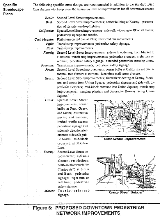

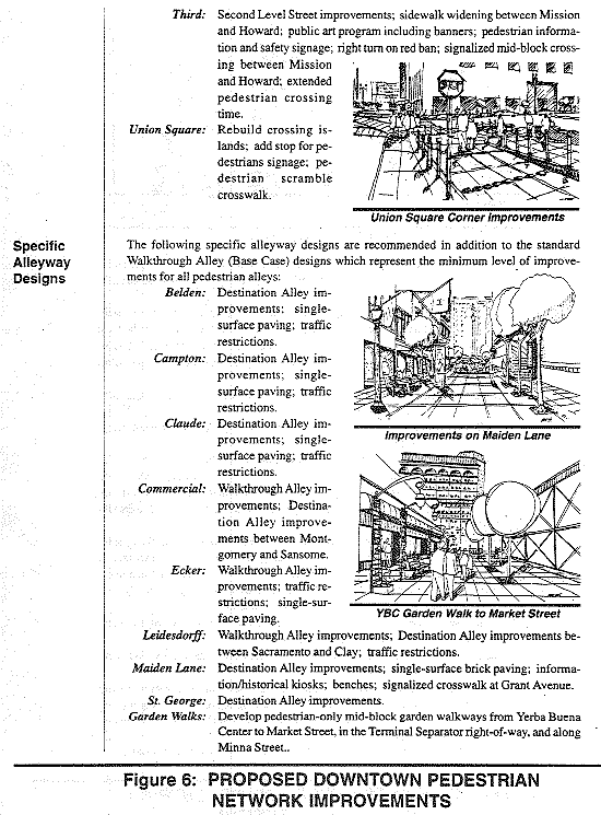
Pursuant to San Francisco Superior Court Order Granting Petition for Peremptory Writ of Mandate, dated November 7, 2006, in Coalition for Adequate Review v. City and County of San Francisco, Case No. 505-509, Ordinance No. 109-05 amending the Downtown Area Plan of the San Francisco General Plan is not enforceable.
Amendments by Planning Commission Resolution 11769 adopted on 10/12/1989.
Amendments by Planning Commission Resolution 13907 adopted on 07/06/1995.
Amendments by Planning Commission Resolution 13909 adopted on 07/13/1995.
Amendments by Board of Supervisors Ordinance 0020-03 adopted on 02/11/2003.
Amendments by Planning Commission Resolution 16749 adopted on 03/18/2004.
Amendments by Planning Commission Resolution 16757 adopted on 03/24/2004.
Amendments by Board of Supervisors Ordinance 0070-04 adopted on 04/20/2004.
Amendments by Board of Supervisors Ordinance 0200-04 adopted on 07/27/2004.
Amendments by Planning Commission Resolution 16906 adopted 12/09/2004.
Amendments by Planning Commission Resolution 16942 adopted 02/03/2005.
Amendments by Planning Commission Resolution 17009 adopted 05/25/2005.
Amendments by Board of Supervisors Ordinance 0125-05 adopted on 06/21/2005.
Amendments by Board of Supervisors Ordinance 0125-06 adopted on 06/06/2006.
Amendments by Board of Supervisors Ordinance 0286-06 adopted on 11/14/2006.
Amendments by Board of Supervisors Ordinance 0091-07 adopted on 04/17/2007.
Amendments by Board of Supervisors Ordinance 0246-07 adopted on 10/23/2007.
Amendments by Board of Supervisors Ordinance 0188-09 adopted on 08/11/2009.
Amendments by Board of Supervisors Ordinance 0185-12 adopted on 07/31/2012.
Amendments by Board of Supervisors Ordinance 0207-15 adopted on 12/01/2015.
Amendments by Board of Supervisors Ordinance 0065-16 adopted on 04/19/2016.
Amendments by Board of Supervisors Ordinance 0252-16 adopted on 12/13/2016.
Amendments by Board of Supervisors Ordinance 0102-17 adopted on 05/16/2017.
Amendments by Board of Supervisors Ordinance 0060-18 adopted on 04/10/2018.
Amendments by Board of Supervisors Ordinance 0018-19 adopted on 01/29/2019.